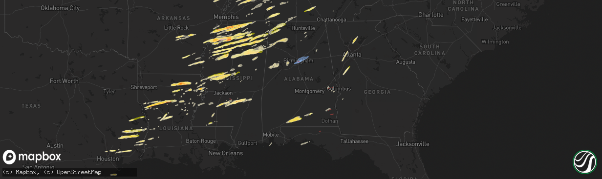
Hail Map in Alabama on December 9, 2023
The weather event in Alabama on December 9, 2023 includes Hail, Wind, and Tornado maps. 9 states and 576 cities were impacted and suffered possible damage. The total estimated number of properties impacted is 34,493.
Hail
Wind
Tornado
34,493
Estimated number of impacted properties by a 1.00" hail or larger0
Estimated number of impacted properties by a 1.75" hail or larger0
Estimated number of impacted properties by a 2.50" hail or largerStorm reports in Alabama
Alabama
| Date | Description |
|---|---|
| 12/09/20235:39 PM CST | Colbert county 911 reported a tree down at the intersection of highway 72 and natchez trace access road. Tree is not blocking the roadway. Time estimated by radar. |
| 12/09/20234:42 AM CST | Reports of possible structures damaged along lee road 11. |
| 12/09/20234:42 AM CST | Resident reports no damage to home but outdoor patio items were blown 20 to 100 feet away from their original location... Knocked over some motorcycles wrapped shade sa |
| 12/09/20234:38 AM CST | Trees down along lee county road 39 between lee road 11 and u.s. Highway 51. Possible tonrado. |
| 12/09/20234:38 AM CST | Corrects previous tstm wnd dmg report from 3 nw marvyn. Trees down along lee county road 39 between lee road 11 and u.s. Highway 51. Possible tornado. |
| 12/09/20234:38 AM CST | Corrects previous tstm wnd dmg reports from 3 nw marvyn. Trees down along lee county road 39 between lee road 11 and alabama highway 51. Possible tornado. |
| 12/09/20234:37 AM CST | Tree reported down along lee road 11. Possible tornado. |
| 12/09/20234:36 AM CST | Trees down blocking lee road 29. |
| 12/09/20234:35 AM CST | Reports of trees down near lee road 11 and u.s. Highway 80. |
| 12/09/20234:25 AM CST | Crenshaw county ema relayed a report of hail up to 1 inch in diameter falling in the southern most portions of the county. Time estimated from radar. |
| 12/09/20231:48 AM CST | Front roof peeled off of the front along with minor siding damage to the cherokee county farmers coop building along cherokee cr 25. Time estimated by radar. |
| 12/09/20231:48 AM CST | Corrects previous tstm wnd dmg report from 1 w centre. Front roof peeled off along with minor front siding damage to the cherokee county farmers coop building along che |
| 12/09/20231:47 AM CST | Tds off eox radar. |
| 12/09/20231:33 AM CST | Henry county emergency management reports several trees down on cr 117... Cr 210... Cr 29... Along with damage to a shed on cr 29. Radar confirmed tornadic debris signa |
| 12/09/20231:20 AM CST | Tds off eox radar. |
| 12/09/202312:50 AM CST | Trees down across the road blocking traffic from both directions. Time estimated by radar. |
| 12/09/202312:23 AM CST | Corrects previous tstm wnd gst report from birmingham international airport for max wind gust speed. |
| 12/09/202312:12 AM CST | Reports of trees down on house at the following locations in mountain brook: locksley drive... Knollwood drive... Eaton road... Cherokee drive... Spring rock road... St |
| 12/09/202312:11 AM CST | Structural damage to a tire service station along green springs highway north of lakeshore parkway via photo. Also snapped trees and additional roof damage visible to a |
| 12/09/202312:11 AM CST | Some roof damage to apartments just east of interstate 65 and north of lakeshore parkway evident in viewer photos submitted to broadcast meteorologist. Time estimated b |
| 12/09/202312:10 AM CST | Numerous trees down on wellington road. |
| 12/09/202312:10 AM CST | Reports of trees down on houses at the following locations in vestavia hills: farringtonwoods drive... Valley park drive... Fleetwood drive and holly oak drive. Time es |
| 12/09/202312:09 AM CST | Damage to a part of the roof of a brick home likely due to a large fallen tree. Time estimated by radar. Report by broadcast meteorologist thorough social media. |
| 12/09/202312:08 AM CST | Tree down on a residence. |
| 12/09/202312:08 AM CST | Corrects previous tstm wnd dmg report from 1 sw homewood. Photos of a vehicle flipped in a hotel parking lot shared via broadcast media on social media. |
| 12/09/202312:07 AM CST | Tree down onto a house. Possible entrapment. |
| 12/09/202312:07 AM CST | Trees down at several locations in the vestavia hills... Bluff park area. |
| 12/09/202312:06 AM CST | Shady brook circle impassible due to downed trees. |
| 12/08/202310:12 PM CST | Tree down on cr 67 in langston. Time estimated from radar. |
| 12/08/20239:30 PM CST | Tree down at cr 109 and cr 30 in scottsboro. Time estimated from radar. |
| 12/08/20239:25 PM CST | Power line down in front of merchants bank in fairview. Time estimated from radar. |
| 12/08/20238:50 PM CST | Tree down with reported road blockage in laceys spring. Time estimated from radar. |
| 12/08/20238:50 PM CST | Adds detail to previous tstm wnd dmg report from 8 wsw owens crossroads. Tree down with reported road blockage on river loop rd... Just east of 231 in laceys spring. Ti |
| 12/08/20237:18 PM CST | Emergency manager reported quarter-size hail at county road 92 in elgin. |
| 12/08/20236:42 PM CST | A tree was knocked down and partially blocking the roadway at the intersection of keller quarry road and bluff ct. Time estimated by radar. |
All States Impacted by Hail Map on December 9, 2023
Cities Impacted by Hail Map on December 9, 2023
- Fulton, KY
- Kenton, TN
- Trimble, TN
- Newbern, TN
- Dyersburg, TN
- Dyer, TN
- Rutherford, TN
- Greenfield, TN
- Sharon, TN
- Dresden, TN
- Gleason, TN
- Humphrey, AR
- Stuttgart, AR
- Humboldt, TN
- Trenton, TN
- Milan, TN
- Indian Mound, TN
- Woodlawn, TN
- Lavinia, TN
- Atwood, TN
- Brownsville, TN
- Bells, TN
- Gadsden, TN
- Clarksville, TN
- Trezevant, TN
- Huntingdon, TN
- McKenzie, TN
- Trenton, KY
- Guthrie, KY
- Tunica, MS
- Coldwater, MS
- Sarah, MS
- Camden, TN
- Hollow Rock, TN
- Bruceton, TN
- Buena Vista, TN
- Senatobia, MS
- Warren, AR
- Wilmar, AR
- Monticello, AR
- Mellwood, AR
- Crumrod, AR
- Clarksdale, MS
- Allensville, KY
- Olmstead, KY
- Russellville, KY
- Medina, TN
- Hernando, MS
- Dundee, MS
- Lyon, MS
- Coahoma, MS
- Holladay, TN
- Byhalia, MS
- Holly Springs, MS
- Red Banks, MS
- Marks, MS
- Sledge, MS
- Waverly, TN
- Hurricane Mills, TN
- New Johnsonville, TN
- Cumberland Furnace, TN
- Vanleer, TN
- Cunningham, TN
- Lamar, MS
- Michigan City, MS
- Ashland, MS
- Westport, TN
- Yuma, TN
- McEwen, TN
- Dickson, TN
- Charlotte, TN
- Sardis, MS
- Crenshaw, MS
- Batesville, MS
- Courtland, MS
- Oxford, MS
- Walnut, MS
- Falkner, MS
- Tiplersville, MS
- White Bluff, TN
- Ashland City, TN
- Burns, TN
- Kingston Springs, TN
- Zwolle, LA
- Belmont, LA
- Pleasant Hill, LA
- Broaddus, TX
- Marthaville, LA
- Robeline, LA
- Pegram, TN
- Nashville, TN
- Springfield, TN
- Bronson, TX
- Taylor, MS
- University, MS
- Shelbyville, KY
- Waddy, KY
- Thaxton, MS
- Cleveland, MS
- Doddsville, MS
- Drew, MS
- Ruleville, MS
- Como, MS
- Pineland, TX
- Abbeville, MS
- Tutwiler, MS
- Sumner, MS
- Lambert, MS
- Charleston, MS
- Enid, MS
- Oakland, MS
- Pope, MS
- Water Valley, MS
- Potts Camp, MS
- Etta, MS
- Myrtle, MS
- Madison, TN
- Natchitoches, LA
- Campti, LA
- Goldonna, LA
- Hemphill, TX
- Cascilla, MS
- Scobey, MS
- Tillatoba, MS
- Minter City, MS
- Mendenhall, MS
- Magee, MS
- Hendersonville, TN
- Ruston, LA
- Choudrant, LA
- Downsville, LA
- Calhoun, LA
- Eros, LA
- Chatham, LA
- Gallatin, TN
- New Albany, MS
- Blue Springs, MS
- Winnfield, LA
- Monroe, LA
- West Monroe, LA
- Sterlington, LA
- Guntown, MS
- Baldwyn, MS
- Paris, MS
- Pontotoc, MS
- Coffeeville, MS
- Raleigh, MS
- Mize, MS
- Liberty, MS
- Goodlettsville, TN
- Woodville, TX
- Ecru, MS
- Banner, MS
- Bruce, MS
- Collinston, LA
- Philipp, MS
- Holcomb, MS
- Grenada, MS
- Dodson, LA
- Olla, LA
- Sikes, LA
- Chester, TX
- Colmesneil, TX
- Taylorsville, MS
- Bay Springs, MS
- Old Hickory, TN
- Oak Ridge, LA
- Mer Rouge, LA
- Whites Creek, TN
- Castalian Springs, TN
- Bethpage, TN
- Livingston, TX
- Kingwood, TX
- Porter, TX
- Huffman, TX
- Humble, TX
- Warren, TX
- Savannah, TN
- Olivehill, TN
- Lutts, TN
- Waynesboro, TN
- Collinwood, TN
- Belden, MS
- Louin, MS
- Tupelo, MS
- Saltillo, MS
- Houlka, MS
- Randolph, MS
- Hillister, TX
- Jasper, TX
- Duck Hill, MS
- Gore Springs, MS
- McCarley, MS
- Lena, LA
- Rolling Fork, MS
- Yazoo City, MS
- Louise, MS
- Mount Juliet, TN
- Lebanon, TN
- Tchula, MS
- Lexington, MS
- Boyce, LA
- Fred, TX
- Dayton, TX
- Shannon, MS
- Eupora, MS
- Calhoun City, MS
- Liberty, TX
- Devers, TX
- Spurger, TX
- Newton, TX
- Kirbyville, TX
- Pineville, LA
- Marietta, MS
- Dennis, MS
- New Site, MS
- Mantachie, MS
- Belmont, MS
- Golden, MS
- Fulton, MS
- Schlater, MS
- Greenwood, MS
- Carrollton, MS
- Alexandria, LA
- Verona, MS
- Mooreville, MS
- Plantersville, MS
- Vardaman, MS
- Mantee, MS
- Houston, MS
- Woodland, MS
- Cedarbluff, MS
- West Point, MS
- Okolona, MS
- Prairie, MS
- Aberdeen, MS
- Vaughan, MS
- Benton, MS
- Pickens, MS
- Amory, MS
- Cherokee, AL
- Tuscumbia, AL
- Florence, AL
- Sheffield, AL
- Muscle Shoals, AL
- Killen, AL
- Lexington, AL
- Rogersville, AL
- Red Bay, AL
- Russellville, AL
- Hamilton, MS
- Durant, MS
- Goodman, MS
- Sallis, MS
- Kosciusko, MS
- Ethel, MS
- Braxton, MS
- Greenville, GA
- Gay, GA
- Senoia, GA
- Brooks, GA
- Birmingham, AL
- Brewton, AL
- Castleberry, AL
- Evergreen, AL
- Andalusia, AL
- Red Level, AL
- Marianna, AR
- West Helena, AR
- Opelika, AL
- Salem, AL
- Fayetteville, TN
- Petersburg, TN
- Shelbyville, TN
- Wartrace, TN
- Tullahoma, TN
- Normandy, TN
- Manchester, TN
- Beaumont, TX
- China, TX
- Clopton, AL
- Abbeville, AL
- Newville, AL
- Headland, AL
- Columbia, AL
- Bonifay, FL
- Auburn, KY
- Woodburn, KY
- Bowling Green, KY
- Lexington, TN
- Iuka, MS
- Wisner, LA
- Sicily Island, LA
- Mayersville, MS
- Caneyville, KY
- Horse Branch, KY
- Hampshire, TN
- Hohenwald, TN
- Centerville, TN
- Duck River, TN
- Dermott, AR
- McGehee, AR
- Arkansas City, AR
- Rohwer, AR
- Hickory Valley, TN
- Ragley, LA
- Pelican, LA
- Saline, LA
- Coushatta, LA
- Henry, TN
- Paris, TN
- Pickens, AR
- Tillar, AR
- Winchester, AR
- Bentonia, MS
- Erin, TN
- Nettleton, MS
- Merigold, MS
- Mound Bayou, MS
- Trenton, GA
- Arab, AL
- Union Grove, AL
- Sondheimer, LA
- Fairview, TN
- Lafayette, TN
- Newellton, LA
- Beech Bluff, TN
- Grayson, LA
- Columbia, LA
- Kelly, LA
- Northport, AL
- Berry, AL
- Tallulah, LA
- Pulaski, TN
- Magnolia, MS
- Clio, AL
- Clayton, AL
- Skipperville, AL
- Ariton, AL
- Hickory Flat, MS
- Harrisonburg, LA
- Gamaliel, KY
- Lumpkin, GA
- Anacoco, LA
- Florien, LA
- Pattison, MS
- Seale, AL
- Hatchechubbee, AL
- Williamstown, KY
- Corinth, KY
- Falmouth, KY
- Burkeville, TX
- Gadsden, AL
- Ohatchee, AL
- Farmerville, LA
- Bastrop, LA
- Rayville, LA
- Pioneer, LA
- Hazlehurst, MS
- Hermanville, MS
- Pittsboro, MS
- Clayton, LA
- Bath Springs, TN
- Scotts Hill, TN
- Saltillo, TN
- Clifton, TN
- Linden, TN
- Decaturville, TN
- Tullos, LA
- Bay, AR
- Black Oak, AR
- Trumann, AR
- Lake City, AR
- Caraway, AR
- Woodstock, GA
- Dawsonville, GA
- Ball Ground, GA
- Cumming, GA
- Alpharetta, GA
- Canton, GA
- West, MS
- Woodbury, GA
- Vicksburg, MS
- Noble, LA
- Bogue Chitto, MS
- Brookhaven, MS
- Smithdale, MS
- McCall Creek, MS
- Dequincy, LA
- Longville, LA
- Singer, LA
- Mansfield, LA
- Converse, LA
- Palmetto, GA
- Huron, TN
- Bradford, TN
- Carthage, MS
- Goodrich, TX
- Shepherd, TX
- Lake Village, AR
- Zavalla, TX
- Redfield, AR
- Jefferson, AR
- Sheridan, AR
- Halls, TN
- Gates, TN
- Ripley, TN
- Delhi, LA
- Mangham, LA
- Baskin, LA
- Itta Bena, MS
- Sunflower, MS
- Houston, TX
- Spring, TX
- Whitesburg, GA
- Smyrna, GA
- Douglasville, GA
- Lithia Springs, GA
- Mableton, GA
- Austell, GA
- Fairburn, GA
- Marietta, GA
- Newnan, GA
- Detroit, AL
- Sulligent, AL
- Soddy Daisy, TN
- Pinson, TN
- Jackson, TN
- Medon, TN
- Luray, TN
- Henderson, TN
- Wabbaseka, AR
- Cullman, AL
- Baileyton, AL
- Leesville, LA
- Gilbert, LA
- Atlanta, LA
- Sherrill, AR
- Altheimer, AR
- Almyra, AR
- Tucker, AR
- England, AR
- White Hall, AR
- Waterloo, AL
- Jonesville, LA
- Smithville, MS
- Hamburg, AR
- Greenville, MS
- Montrose, AR
- Blue Mountain, MS
- Summit, MS
- Sweeny, TX
- Tishomingo, MS
- Georgetown, MS
- Starkville, MS
- Jena, LA
- Rosepine, LA
- Deridder, LA
- Buna, TX
- Deweyville, TX
- Call, TX
- Carrollton, AL
- Starks, LA
- Haleyville, AL
- Lake Providence, LA
- Cary, MS
- Holly Bluff, MS
- Colfax, LA
- Double Springs, AL
- Bear Creek, AL
- Moulton, AL
- Hamilton, AL
- Houston, AL
- Guin, AL
- Hackleburg, AL
- Santa Rosa Beach, FL
- Miramar Beach, FL
- Boyle, MS
- Shaw, MS
- Pitkin, LA
- Beaverton, AL
- Macon, MS
- Brooksville, MS
- Paulding, MS
- Pinola, MS
- Dozier, AL
- Brantley, AL
- Galveston, TX
- Freeport, TX
- Centreville, MS
- Weir, MS
- Kilmichael, MS
- McCool, MS
- French Camp, MS
- Pachuta, MS
- Vossburg, MS
- Rose Hill, MS
- Tremont, MS
- El Campo, TX
- Lexa, AR
- Helena, AR
- Saint Joseph, LA
- Elaine, AR
- Vance, MS
- Alligator, MS
- Crosby, TX
- Bolivar, TN
- Wiergate, TX
- Hartsville, TN
- Williamsport, TN
- Gordo, AL
- Monterey, LA
- Harrisville, MS
- Nome, TX
- Elba, AL
- Winona, MS
- Eva, TN
- Owens Cross Roads, AL
- Huntsville, AL
- New Hope, AL
- Cedar Grove, TN
- Wesson, MS
- Lobelville, TN
- Sugar Tree, TN
- Dauphin Island, AL
- Brent, AL
- Echola, AL
- Elrod, AL
- Buhl, AL
- Coker, AL
- Friendship, TN
- Alamo, TN
- Brookwood, AL
- Adger, AL
- West Columbia, TX
- Lorman, MS
- Port Gibson, MS
- Transylvania, LA
- Mora, LA
- Destin, FL
- Waterproof, LA
- Leoma, TN
- Prospect, TN
- Anderson, AL
- Five Points, TN
- Goodspring, TN
- Minor Hill, TN
- Silsbee, TX
- Vidor, TX
- Indianola, MS
- Parsons, TN
- Joelton, TN
- Counce, TN
- Addison, AL
- Danville, AL
- Greenwood Springs, MS
- Newhebron, MS
- Reform, AL
- Mccomb, MS
- Auburn, AL
- Saratoga, TX
- Only, TN
- Covington, TN
- Henning, TN
- Oakfield, TN
- Wildersville, TN
- Darden, TN
- Kountze, TX
- Bellefontaine, MS
- Opp, AL
- Bessemer, AL
- Leeds, AL
- Pell City, AL
- Odenville, AL
- Trussville, AL
- Moody, AL


