Hail Map in Virginia on September 8, 2023
The weather event in Virginia on September 8, 2023 includes Hail and Wind maps. 27 states and 1,020 cities were impacted and suffered possible damage. The total estimated number of properties impacted is 15,998.
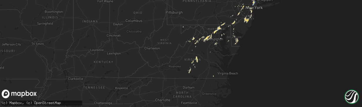
Hail
Wind
15,998
Estimated number of impacted properties by a 1.00" hail or larger0
Estimated number of impacted properties by a 1.75" hail or larger0
Estimated number of impacted properties by a 2.50" hail or largerStorm reports in Virginia
Virginia
| Date | Description |
|---|---|
| 09/08/20236:59 PM CDT | Quarter sized hail observed near the intersection of state road 646 and route 24. |
| 09/08/20236:42 PM CDT | Tree downed by thunderstorm winds near on old evergreen road. |
| 09/08/20236:39 PM CDT | Tree downed by thunderstorm winds near the intersection of bowler creek road and rocks church road. |
| 09/08/20236:37 PM CDT | Tree downed by thunderstorm winds on forest chapel road. |
| 09/08/20236:12 PM CDT | Multiple trees down along a line from just east of brookneal to hat creek community. |
| 09/08/20236:09 PM CDT | Trees down on dog creek road. |
| 09/08/20236:08 PM CDT | Tree down on a powerline on mattox street. |
| 09/08/20236:08 PM CDT | Tree and powerlines down on cook ave. |
| 09/08/20236:05 PM CDT | Trees blew down near the intersection of va-601 shelter lane and greenville drive. |
| 09/08/20236:00 PM CDT | Numerous trees and powerlines down near the intersection of mill creek road and waterfall road |
| 09/08/20236:00 PM CDT | Tree knocked down and powerlines down. Time estimated from radar. |
| 09/08/20235:53 PM CDT | Two trees down on aspen road. |
| 09/08/20235:44 PM CDT | Two trees down on coles ferry loop road. |
| 09/08/20235:43 PM CDT | One tree down across ridgeway road. |
| 09/08/20235:35 PM CDT | Another round of quarter size hail was observed at the nws sterling office. |
| 09/08/20235:35 PM CDT | Another round of quarter to ping pong ball size hail was observed at the nws sterling office between 6:35 and 6:40 pm. |
| 09/08/20235:35 PM CDT | A tree was blown down by thunderstorm winds near the intersection of cove road and neals corner road. |
| 09/08/20235:35 PM CDT | Another round of quarter to ping pong ball size hail was observed at the nws sterling office between 6:35 and 6:45 pm. |
| 09/08/20235:15 PM CDT | Wind gusts of up to 62 knots |
| 09/08/20235:10 PM CDT | A local report indicates 1.25 inch wind near 3 WSW Sterling Park |
| 09/08/20235:00 PM CDT | Hail of up to half dollar size was observed for about 15 minutes from 6:00 to 6:15 pm at the nws office in sterling. Hail covered the ground. |
| 09/08/20234:42 PM CDT | A local report indicates 1.00 inch wind near Arcola |
| 09/08/20234:38 PM CDT | Quarter size hail was reported south of arcola. |
| 09/08/20234:36 PM CDT | Multiple reports of quarter-sized hail in the chantilly and south riding areas |
| 09/08/20234:24 PM CDT | A local report indicates 1.00 inch wind near Basye |
| 09/08/20234:15 PM CDT | A wind gust of 50 knots |
| 09/08/20233:35 PM CDT | A local report indicates 1.00 inch wind near 2 S Alonzaville |
| 09/07/20238:27 PM CDT | 911 call center reported a tree down on i-64 near mile marker 131.5. |
| 09/07/20238:26 PM CDT | Calls for a couple individual trees down in/near keswick. |
| 09/07/20238:26 PM CDT | Calls for a couple individual trees down in/near keswick. |
| 09/07/20238:15 PM CDT | Numerous trees and powerlines down countywide. |
| 09/07/20238:15 PM CDT | Report from mping: 1-inch tree limbs broken; shingles blown off. |
| 09/07/20238:12 PM CDT | 911 call center reported tons of trees and tons of power lines down across fluvanna county. |
| 09/07/20238:02 PM CDT | Calls for several trees down in and around woodridge. |
| 09/07/20237:54 PM CDT | A couple calls for trees down in and around scottsville. |
| 09/07/20237:29 PM CDT | Tree downed by thunderstorm winds near the intersection of patterson road and howardsville road. |
| 09/07/20237:15 PM CDT | Tree downed by thunderstorm winds near the intersection of woods road and texas school road. |
| 09/07/20237:14 PM CDT | Two trees down on possum island road. |
| 09/07/20237:12 PM CDT | Tree downed by thunderstorm winds near the intersection of candlers mountain road and sunnymeade road. |
| 09/07/20237:03 PM CDT | Two trees downed by thunderstorm winds near the intersection of mount rush highway and toga road. |
All States Impacted by Hail Map on September 8, 2023
Cities Impacted by Hail Map on September 8, 2023
- Howard, KS
- Amity, AR
- Kirby, AR
- Murfreesboro, AR
- Delight, AR
- Prescott, AR
- Blevins, AR
- Crescent City, FL
- Bunnell, FL
- Coventry, CT
- Storrs Mansfield, CT
- West Brookfield, MA
- Brookfield, MA
- Provencal, LA
- Mayo, FL
- Eustis, FL
- Umatilla, FL
- Woodville, MS
- Marksville, LA
- Alexandria, LA
- Hessmer, LA
- Lecompte, LA
- Ocala, FL
- Orlando, FL
- Aynor, SC
- Monroe, LA
- Mount Ida, AR
- Norman, AR
- Effie, LA
- Slagle, LA
- Leesville, LA
- Caddo Gap, AR
- Tabor City, NC
- Emmet, AR
- Plain Dealing, LA
- Palm Coast, FL
- Christmas, FL
- Gilbert, LA
- Evergreen, NC
- Bladenboro, NC
- Rosston, AR
- Chadbourn, NC
- Perry, FL
- Daytona Beach, FL
- Port Orange, FL
- White Oak, NC
- Tar Heel, NC
- Oden, AR
- Mena, AR
- Winnsboro, LA
- Wisner, LA
- Okolona, AR
- Glenwood, AR
- Antoine, AR
- Langley, AR
- Bolton, CT
- Hebron, CT
- Andover, CT
- Saint Cloud, FL
- Florien, LA
- Hampton, AR
- Seville, FL
- Winter Garden, FL
- Ocoee, FL
- Punta Gorda, FL
- Green Sea, SC
- Loris, SC
- Cocoa, FL
- Deville, LA
- Titusville, FL
- Seneca, MO
- North Brookfield, MA
- Barryville, NY
- Pond Eddy, NY
- Shohola, PA
- Glen Spey, NY
- Sparrow Bush, NY
- Millrift, PA
- East Rutherford, NJ
- Rutherford, NJ
- Lyndhurst, NJ
- Wallington, NJ
- Carlstadt, NJ
- Lodi, NJ
- Rochelle Park, NJ
- Hasbrouck Heights, NJ
- Garfield, NJ
- Wood Ridge, NJ
- South Hackensack, NJ
- Moonachie, NJ
- Maywood, NJ
- Bogota, NJ
- Hackensack, NJ
- Little Ferry, NJ
- Teterboro, NJ
- Ridgefield Park, NJ
- River Edge, NJ
- Emerson, NJ
- Westwood, NJ
- New Milford, NJ
- Oradell, NJ
- Teaneck, NJ
- Paramus, NJ
- Orangeburg, NY
- Tappan, NY
- Dumont, NJ
- Demarest, NJ
- Palisades, NY
- Northvale, NJ
- Cresskill, NJ
- Tenafly, NJ
- Bergenfield, NJ
- Norwood, NJ
- Closter, NJ
- Harrington Park, NJ
- Haworth, NJ
- Lake Charles, LA
- Hackberry, LA
- Sulphur, LA
- Sparkill, NY
- Blauvelt, NY
- Nyack, NY
- Piermont, NY
- Blooming Grove, NY
- Washingtonville, NY
- Salisbury Mills, NY
- Rock Tavern, NY
- Brattleboro, VT
- West Chesterfield, NH
- Hinsdale, NH
- Winchester, NH
- Troy, NH
- Swanzey, NH
- Westmoreland, NH
- Putney, VT
- Morrisville, NC
- Raleigh, NC
- Hampton Falls, NH
- Stratham, NH
- Portsmouth, NH
- Newmarket, NH
- Greenland, NH
- Seabrook, NH
- Rye, NH
- Kittery, ME
- Amesbury, MA
- Rye Beach, NH
- North Hampton, NH
- Durham, NH
- New Castle, NH
- Hampton, NH
- East Kingston, NH
- Salisbury, MA
- Exeter, NH
- York, ME
- Cape Neddick, ME
- Eliot, ME
- Madbury, NH
- Dover, NH
- Kittery Point, ME
- Ogunquit, ME
- South Berwick, ME
- Wells, ME
- Kennebunkport, ME
- Kennebunk, ME
- North Berwick, ME
- Rollinsford, NH
- Old Orchard Beach, ME
- Saco, ME
- Biddeford Pool, ME
- South Portland, ME
- Ocean Park, ME
- Biddeford, ME
- Berwick, ME
- Scarborough, ME
- Sanford, ME
- Alfred, ME
- Buxton, ME
- Newfields, NH
- Newburyport, MA
- Ipswich, MA
- Byfield, MA
- Rowley, MA
- Newbury, MA
- Merrimac, MA
- Andover, MA
- Haverhill, MA
- Groveland, MA
- West Newbury, MA
- Boxford, MA
- Lowell, MA
- Georgetown, MA
- North Andover, MA
- Tewksbury, MA
- Topsfield, MA
- Lawrence, MA
- South Hamilton, MA
- Wilmington, MA
- Billerica, MA
- Middleton, MA
- North Billerica, MA
- North Reading, MA
- Methuen, MA
- Woodstock, VA
- Aldie, VA
- Chantilly, VA
- Sterling, VA
- Ashburn, VA
- Plymouth, NH
- Holderness, NH
- Centreville, VA
- Catharpin, VA
- Mount Jackson, VA
- Broadway, VA
- Timberville, VA
- Walters, OK
- Fuquay Varina, NC
- Willow Spring, NC
- Haymarket, VA
- Frederick, OK
- Hollister, OK
- Loveland, OK
- Temple, OK
- Perkinsville, VT
- Springfield, VT
- Rowe, MA
- Maringouin, LA
- Livonia, LA
- Shawmut, MT
- Alton Bay, NH
- Columbus, NJ
- Carmel, NY
- Milton, NY
- Highland, NY
- Wallkill, NY
- Highland Falls, NY
- Bear Mountain, NY
- Fort Montgomery, NY
- Garrison, NY
- Kissimmee, FL
- Spring Hope, NC
- Franklin, LA
- Ryegate, MT
- Shirley, MA
- Groton, MA
- Stow, MA
- Vincentown, NJ
- Cary, NC
- Apex, NC
- Brimfield, MA
- Warren, MA
- East Brookfield, MA
- Quinton, OK
- Rose Hill, NC
- Oakdale, LA
- Fulks Run, VA
- Bergton, VA
- Greenfield, MA
- Bernardston, MA
- Colrain, MA
- New Milford, CT
- Bridgewater, CT
- Washington Depot, CT
- New Fairfield, CT
- Sherman, CT
- Frederica, DE
- Magnolia, DE
- Moore Haven, FL
- Cranford, NJ
- Roselle, NJ
- Roselle Park, NJ
- Clark, NJ
- Linden, NJ
- Hanna, OK
- Eufaula, OK
- Weleetka, OK
- Henryetta, OK
- Kenilworth, NJ
- Rahway, NJ
- White Sulphur Springs, MT
- Madison, NJ
- Chatham, NJ
- Green Village, NJ
- Florham Park, NJ
- Milford, DE
- Milton, DE
- Lincoln, DE
- Ellendale, DE
- Crowley, LA
- Morse, LA
- Patterson, LA
- Broad Run, VA
- Rocky Mount, NC
- Centreville, MS
- Gloster, MS
- Crosby, MS
- Pinetops, NC
- Macclesfield, NC
- Elm City, NC
- Dudley, MA
- Georgetown, DE
- Jasper, TX
- Ballston Lake, NY
- Garland, NC
- Clinton, NC
- Port Arthur, TX
- Beaumont, TX
- Stephentown, NY
- Pittsfield, MA
- New Lebanon, NY
- Pineville, LA
- Devers, TX
- New Egypt, NJ
- Browns Mills, NJ
- Pemberton, NJ
- Wrightstown, NJ
- Jobstown, NJ
- Mount Holly, NJ
- Manchester Township, NJ
- Trenton, NJ
- Allentown, NJ
- Chesterfield, NJ
- Joint Base Mdl, NJ
- Jackson, NJ
- Lakehurst, NJ
- Cookstown, NJ
- Monroe, NY
- Warwick, NY
- Greenwood Lake, NY
- Maurertown, VA
- Edinburg, VA
- Schenectady, NY
- Amsterdam, NY
- Ballston Spa, NY
- Florence, MA
- Easthampton, MA
- Gainesville, VA
- Gilmanton Iron Works, NH
- Alton, NH
- Markham, VA
- Linden, VA
- Bolton, MA
- Conway, SC
- Staten Island, NY
- Elizabeth, NJ
- Elizabethport, NJ
- Hillside, NJ
- Harbeson, DE
- Tomkins Cove, NY
- Garnerville, NY
- West Haverstraw, NY
- Stony Point, NY
- Buchanan, NY
- Haverstraw, NY
- Verplanck, NY
- Montrose, NY
- Hazlet, NJ
- Keyport, NJ
- Cliffwood, NJ
- Morganville, NJ
- Matawan, NJ
- Holmdel, NJ
- Fayetteville, NC
- Adams, MA
- Stockton, NJ
- Ringoes, NJ
- Flemington, NJ
- Lake Placid, FL
- Worcester, MA
- Auburn, MA
- Millbury, MA
- Brownfield, ME
- Wewoka, OK
- Okemah, OK
- Wetumka, OK
- Mamou, LA
- Ville Platte, LA
- Castle, OK
- Paden, OK
- Holdenville, OK
- Fellsmere, FL
- Palm Bay, FL
- Donaldsonville, LA
- Belle Rose, LA
- Goldsboro, NC
- White Castle, LA
- Plaquemine, LA
- Sudbury, MA
- Framingham, MA
- Pittstown, NJ
- Annandale, NJ
- Clinton, NJ
- Frenchtown, NJ
- Camden Wyoming, DE
- Jackson, LA
- Saint Francisville, LA
- Woodcliff Lake, NJ
- Township Of Washington, NJ
- Ridgewood, NJ
- Saddle River, NJ
- Park Ridge, NJ
- Ho Ho Kus, NJ
- Hillsdale, NJ
- Oakham, MA
- Rutland, MA
- Orange, TX
- Vinton, LA
- Sebring, FL
- Lancaster, MA
- Lunenburg, MA
- Leominster, MA
- Campbell Hall, NY
- Ivanhoe, NC
- Harrells, NC
- Coats, NC
- Benson, NC
- Vernon, VT
- Northfield, MA
- Canal Point, FL
- Union, NJ
- Pitkin, LA
- Saddle Brook, NJ
- Durham, NC
- Natick, MA
- Sherborn, MA
- Boxborough, MA
- Littleton, MA
- Clinton, MA
- Harvard, MA
- Berlin, MA
- Hudson, MA
- Luray, VA
- Dulac, LA
- Two Dot, MT
- Chichester, NH
- Hartshorne, OK
- Mcalester, OK
- Farmingdale, NJ
- Freehold, NJ
- Marlboro, NJ
- Colts Neck, NJ
- Vero Beach, FL
- Okeechobee, FL
- Stuyvesant, NY
- Valatie, NY
- Schodack Landing, NY
- Niverville, NY
- Middletown, NY
- Jeanerette, LA
- East Nassau, NY
- Nassau, NY
- Sperryville, VA
- Bentonville, VA
- Washington, VA
- Holland, MA
- Fiskdale, MA
- Sturbridge, MA
- Marshall, VA
- Middleburg, VA
- Upperville, VA
- Lewes, DE
- Salem, NJ
- Maybrook, NY
- Goshen, NY
- Chester, NY
- Montgomery, NY
- Tuxedo Park, NY
- Wilson, NC
- Hannacroix, NY
- Kinderhook, NY
- West Coxsackie, NY
- New Baltimore, NY
- Coeymans, NY
- Selkirk, NY
- Ravena, NY
- Dover, DE
- Mittie, LA
- Oberlin, LA
- Thiells, NY
- Naylor, GA
- Monterey, LA
- Winnie, TX
- Melbourne, FL
- Batson, TX
- New Windsor, NY
- Harriman, NY
- Central Valley, NY
- Highland Mills, NY
- Otisville, NY
- Boley, OK
- Bristow, OK
- Depew, OK
- Stroud, OK
- Lebanon, NJ
- Califon, NJ
- Norwood, LA
- Ashford, CT
- Sloatsburg, NY
- Hillburn, NY
- Pottstown, PA
- Savoy, MA
- The Plains, VA
- Porter, ME
- Denmark, ME
- La Grange, NC
- Cheneyville, LA
- Chapel Hill, NC
- Mount Olive, NC
- Faison, NC
- Warsaw, NC
- Loxahatchee, FL
- Clinton, LA
- Fremont, NC
- Perkasie, PA
- Chalfont, PA
- Fountainville, PA
- Pipersville, PA
- Doylestown, PA
- Lansdale, PA
- New Hope, PA
- Elverson, PA
- Climax, NY
- Greenville, NY
- Castleton On Hudson, NY
- South Bethlehem, NY
- Earlton, NY
- Surprise, NY
- Freehold, NY
- Coeymans Hollow, NY
- Smyrna, DE
- Kingwood, TX
- Splendora, TX
- New Caney, TX
- Porter, TX
- Marlborough, MA
- Southborough, MA
- Middlesex, NC
- Monsey, NY
- Nashville, NC
- Castalia, NC
- Harman, WV
- Whitmer, WV
- Seneca Rocks, WV
- Jefferson, NY
- Summit, NY
- Delaplane, VA
- Ethel, LA
- Long Valley, NJ
- Kenansville, FL
- Gilmanton, NH
- Lakewood, NJ
- Howell, NJ
- New Iberia, LA
- Lottie, LA
- Fordoche, LA
- Glen Gardner, NJ
- Magnolia, NC
- Whitehall, MT
- Grosse Tete, LA
- Lanesborough, MA
- Eastford, CT
- Felton, DE
- Stedman, NC
- Indianola, OK
- Center Barnstead, NH
- Toms Brook, VA
- Loudon, NH
- Rockledge, FL
- Townsend, DE
- Sewaren, NJ
- Port Reading, NJ
- Perth Amboy, NJ
- Keasbey, NJ
- Woodbridge, NJ
- Avenel, NJ
- Great Falls, VA
- Chester, VT
- Saint Martinville, LA
- Plymouth, NC
- Roper, NC
- Huguenot, NY
- Matamoras, PA
- Hawley, PA
- Greeley, PA
- Milford, PA
- Lucama, NC
- Breaux Bridge, LA
- Laurel, DE
- Boylston, MA
- Acton, MA
- Shrewsbury, MA
- West Boylston, MA
- Northborough, MA
- Seven Springs, NC
- Dudley, NC
- Wade, NC
- Leesburg, VA
- Englishtown, NJ
- Millstone Township, NJ
- Angier, NC
- Dunn, NC
- Millsboro, DE
- Abbeville, LA
- Youngsville, LA
- Erath, LA
- Delcambre, LA
- Canadian, OK
- Southfields, NY
- Montvale, NJ
- Spring Valley, NY
- Peekskill, NY
- West Nyack, NY
- Nanuet, NY
- Suffern, NY
- West Point, NY
- New City, NY
- Cortlandt Manor, NY
- Pearl River, NY
- Zebulon, NC
- Woodstock, CT
- Woodstock Valley, CT
- Glady, WV
- Hopewell Junction, NY
- Stantonsburg, NC
- Black Creek, NC
- Pikeville, NC
- Bedford, MA
- Burlington, MA
- Dayton, MD
- Ellicott City, MD
- Clarksville, MD
- West Friendship, MD
- Magnolia, TX
- Pinehurst, TX
- Rapid City, SD
- Ellsworth Afb, SD
- Box Elder, SD
- Davidson, OK
- Marriottsville, MD
- Windsor Mill, MD
- Randallstown, MD
- Woodstock, MD
- Sparks Glencoe, MD
- Cockeysville, MD
- Hunt Valley, MD
- Stevenson, MD
- Owings Mills, MD
- Pikesville, MD
- Phoenix, MD
- Gladstone, VA
- Buckingham, VA
- Dillwyn, VA
- Monkton, MD
- Baldwin, MD
- New Underwood, SD
- Owanka, SD
- Gainesville, TX
- Clarksville, TX
- Detroit, TX
- Bagwell, TX
- Bogata, TX
- Mount Pleasant, TX
- Talco, TX
- Cookville, TX
- Wasta, SD
- New Canton, VA
- Bremo Bluff, VA
- Palmyra, VA
- Fork Union, VA
- Arvonia, VA
- Diana, TX
- Longview, TX
- Hallsville, TX
- Sterling, MA
- Wilmington, DE
- Marcus Hook, PA
- Garnet Valley, PA
- Chadds Ford, PA
- Montchanin, DE
- Rockland, DE
- Round Lake, NY
- Mechanicville, NY
- Fort Worth, TX
- Newark, TX
- Haslet, TX
- Rhome, TX
- Azle, TX
- Boyd, TX
- Aledo, TX
- Naval Air Station Jrb, TX
- Franklin, WV
- Upper Tract, WV
- Crowley, TX
- Spencerville, OK
- Rattan, OK
- Fort Towson, OK
- Sawyer, OK
- Joshua, TX
- Burleson, TX
- Cleburne, TX
- Antlers, OK
- Soper, OK
- Hugo, OK
- Godley, TX
- Keene, TX
- Alvarado, TX
- Lillian, TX
- Mansfield, TX
- Granbury, TX
- Honey Grove, TX
- Petty, TX
- Sumner, TX
- Rio Vista, TX
- Grandview, TX
- Venus, TX
- Midlothian, TX
- Blum, TX
- Hermosa, SD
- Grandfield, OK
- Tolland, CT
- Port Murray, NJ
- Washington, NJ
- Belvidere, NJ
- Windsor, CT
- Bloomfield, CT
- Daingerfield, TX
- Hackettstown, NJ
- Phenix, VA
- Garryowen, MT
- McHenry, MD
- Accident, MD
- Shepherd, MT
- Amherst, MA
- Leverett, MA
- Canadensis, PA
- Campton, NH
- Thornton, NH
- Williamsburg, MA
- Haydenville, MA
- Leeds, MA
- Hume, VA
- Huntly, VA
- Manchester, NH
- Hooksett, NH
- Princeton, NJ
- Daisy, OK
- Charlemont, MA
- Tatum, TX
- Hubbardston, MA
- Muenster, TX
- Gaithersburg, MD
- Shelburne Falls, MA
- Windsor, VT
- Feura Bush, NY
- Glenmont, NY
- Delmar, NY
- Glenelg, MD
- Sykesville, MD
- Chatsworth, NJ
- Bordentown, NJ
- Candia, NH
- Deerfield, NH
- Cumberland, VA
- Nashoba, OK
- Elkton, MD
- North East, MD
- Ahoskie, NC
- Como, NC
- Murfreesboro, NC
- Boling, TX
- Pledger, TX
- Bath, PA
- Tenaha, TX
- Purcellville, VA
- Kilgore, TX
- Ashland, MA
- Franklin, VA
- Newsoms, VA
- Courtland, VA
- Easton, PA
- Bangor, PA
- Gary, TX
- Northampton, MA
- Pylesville, MD
- Fawn Grove, PA
- Peach Bottom, PA
- Drumore, PA
- Delta, PA
- Whiteford, MD
- Ardmore, OK
- Springer, OK
- Malta, MT
- Columbia, MD
- Valliant, OK
- Ringold, OK
- High Bridge, NJ
- Princeton, MA
- Fitchburg, MA
- Columbia, VA
- Haworth, OK
- Waldorf, MD
- Lutherville Timonium, MD
- Poolesville, MD
- Potomac, MD
- Germantown, MD
- Ashuelot, NH
- Stafford Springs, CT
- Brookneal, VA
- Carthage, TX
- Charlotte Court House, VA
- Halifax, VA
- Crystal Hill, VA
- Randolph, VA
- Nathalie, VA
- Electra, TX
- Harrold, TX
- Piedmont, SD
- Jefferson, MA
- Brownsville, VT
- Oxford, MA
- Cresco, PA
- De Kalb, TX
- Royalston, MA
- Granville, MA
- Southampton, MA
- Hadley, MA
- Hatfield, MA
- Finley, OK
- Robbinsville, NJ
- Oxford, CT
- Waterbury, CT
- Prospect, CT
- Naugatuck, CT
- Farmville, VA
- Dingmans Ferry, PA
- Clayton, OK
- Pittsburg, OK
- Snow, OK
- Arthur City, TX
- Ashfield, MA
- West Halifax, VT
- Conway, MA
- Chadron, NE
- Rileyville, VA
- Blandford, MA
- Russell, MA
- Gilbertsville, PA
- Van Vleck, TX
- Sweeny, TX
- Port Royal, VA
- Criders, VA
- Clewiston, FL
- Broken Bow, OK
- Wright City, OK
- Red House, VA
- Wilburton, OK
- Paxton, MA
- Holden, MA
- Brainard, NY
- White Plains, MD
- Wall, SD
- Dodson, MT
- Windsor, MA
- Ware, MA
- Scottsville, VA
- Geronimo, OK
- Bethany, CT
- Beacon Falls, CT
- Pasadena, MD
- Idabel, OK
- Bryantown, MD
- Foreman, AR
- Avery, TX
- Annona, TX
- West Lebanon, NH
- Lebanon, NH
- Plantsville, CT
- Cheshire, CT
- Southington, CT
- Huntington, MA
- Rockville, MD
- Prospect, VA
- Reisterstown, MD
- Glen Arm, MD
- Newburgh, NY
- Wappingers Falls, NY
- Ore City, TX
- Harleton, TX
- Jefferson, TX
- Henderson, TX
- Parkton, MD
- Hydes, MD
- White Hall, MD
- Cooksville, MD
- Glenwood, MD
- Jarrettsville, MD
- Quarryville, PA
- Street, MD
- Hancock, NH
- Bennington, NH
- Antrim, NH
- Brogue, PA
- Airville, PA
- Ochopee, FL
- Covington, TX
- Roxton, TX
- Mabank, TX
- Trinidad, TX
- Dike, TX
- Sulphur Springs, TX
- Olney, MD
- Weatherford, TX
- Cresson, TX
- Webster, MA
- Malakoff, TX
- Bennington, OK
- Boswell, OK
- Lufkin, TX
- Reklaw, TX
- Laneville, TX
- Cushing, TX
- Charlotte Hall, MD
- Bokchito, OK
- Caddo, OK
- Caney, OK
- Atoka, OK
- Hurst, TX
- Nacogdoches, TX
- Grapeland, TX
- Alto, TX
- Wells, TX
- Arlington, TX
- Brookston, TX
- Gibson Island, MD
- Rock Hall, MD
- Banco, VA
- Madison, VA
- Washington, DC
- La Plata, MD
- Brandywine, MD
- Pomona Park, FL
- Nokesville, VA
- Catlett, VA
- Woodville, VA
- Euless, TX
- Bedford, TX
- Tupelo, OK
- Wapanucka, OK
- Chester, TX
- Athens, TX
- Kemp, TX
- Kerens, TX
- Aston, PA
- Media, PA
- Chester Heights, PA
- Glen Mills, PA
- Kennedale, TX
- Huntington, TX
- Riverton, WV
- Pittsburg, TX
- Newtown Square, PA
- Yorklyn, DE
- Hockessin, DE
- Sour Lake, TX
- Stonewall, OK
- Crozet, VA
- Free Union, VA
- Woodville, TX
- Paris, TX
- Tishomingo, OK
- Milburn, OK
- Roff, OK
- Chester Gap, VA
- Montalba, TX
- Gilmer, TX
- Edgewater, MD
- Annapolis, MD
- Broaddus, TX
- Brookeville, MD
- Bethesda, MD
- Vienna, VA
- McLean, VA
- Manassas, VA
- Warrenton, VA
- Fort McCoy, FL
- Clinton, MD
- Springtown, TX
- Jordan, MT
- Larue, TX
- Leesburg, TX
- Moyers, OK
- Kennard, TX
- Denton, MD
- Easton, MD
- Preston, MD
- Haverford, PA
- Bryn Mawr, PA
- Frankston, TX
- Lindsay, TX
- Oakton, VA
- Reston, VA
- Herndon, VA
- Fairfax, VA
- Palestine, TX
- Upper Black Eddy, PA
- Gibbstown, NJ
- Houston, TX
- Humble, TX
- Spring, TX
- Oxon Hill, MD
- Montgomery Village, MD
- Washington Grove, MD
- Derwood, MD
- Fallston, MD
- Fork, MD
- Falls Church, VA
- Naval Anacost Annex, DC
- Newark, DE
- Andover, SD
- Groton, SD


