Hail Map in Nebraska on August 10, 2023
The weather event in Nebraska on August 10, 2023 includes Hail and Wind maps. 19 states and 545 cities were impacted and suffered possible damage. The total estimated number of properties impacted is 12,205.
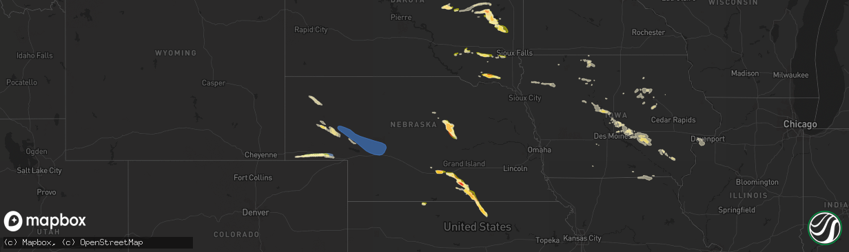
Hail
Wind
12,205
Estimated number of impacted properties by a 1.00" hail or larger4,316
Estimated number of impacted properties by a 1.75" hail or larger1,047
Estimated number of impacted properties by a 2.50" hail or largerStorm reports in Nebraska
Nebraska
| Date | Description |
|---|---|
| 08/10/20236:50 PM CDT | A local report indicates 1.25 inch wind near 13 NW Ericson |
| 08/10/20235:45 PM CDT | A local report indicates 62 MPH wind near 3 SE Sidney |
| 08/10/20235:40 PM CDT | Nickel size hail with some quarters mixed in. |
| 08/10/20235:35 PM CDT | A local report indicates 67 MPH wind near Sidney |
| 08/10/20235:35 PM CDT | 7 inch diameter tree limb down. |
| 08/10/20235:34 PM CDT | A local report indicates 1.00 inch wind near 1 W Sidney |
| 08/10/20235:25 PM CDT | Mostly dime to nickel size hail with a few quarters. |
| 08/10/20235:25 PM CDT | Em report of quarter size hail in parts of kearney. |
| 08/10/20235:25 PM CDT | Report with photo from social media. Time estimated from radar. |
| 08/10/20235:20 PM CDT | Half dollar |
| 08/10/20235:18 PM CDT | Social media report with photo of hail northwest of kearney relayed from emergency manager. Location is approximated from radar. |
| 08/10/20235:18 PM CDT | Delayed report via social media of hail at least half dollar size south of riverdale. Time estimated based on radar. |
| 08/09/20239:10 PM CDT | A local report indicates 67 MPH wind near 1 NW Sutherland |
| 08/09/20238:47 PM CDT | A local report indicates 1.50 inch wind near 6 NNE Bostwick |
| 08/09/20238:43 PM CDT | Em passed public report from picture on social media. |
| 08/09/20238:40 PM CDT | Public report. Estimated 60 mph winds. |
| 08/09/20238:35 PM CDT | Fire department in nuckolls county reports golf ball to tennis ball sized hail near the junction of highways 136 and 14. Time estimated based on radar. |
| 08/09/20238:18 PM CDT | Emergency manager reported quarter to golf ball sized hail near roads 3100 and l. Time estimated based on radar. |
| 08/09/20238:18 PM CDT | Social media report of egg size hail southeast of lawrence. Time estimated from radar. |
| 08/09/20238:13 PM CDT | Social media report of ping pong ball size hail south of lawrence. |
| 08/09/20238:12 PM CDT | Delayed report via social media of hail slightly larger than golf balls. Time estimated based on radar. |
| 08/09/20238:07 PM CDT | Social media report of ping pong ball size hail. Time estimated from radar. |
| 08/09/20237:45 PM CDT | Public report of 1.5 to 2 inch hail based on measurements. |
| 08/09/20237:45 PM CDT | Time estimated from radar. |
| 08/09/20237:45 PM CDT | Time estimated from radar. Pictures sent via social media. |
| 08/09/20237:38 PM CDT | Delayed report via social media report of damage to a corn field due to hail and wind. Hail size estimated to be around nickel to quarter. Time estimated based on radar |
| 08/09/20237:35 PM CDT | A local report indicates 65 MPH wind near Crescent Lake Nwr |
| 08/09/20237:30 PM CDT | Report with photo of golf ball sized hail near ayr. |
| 08/09/20237:15 PM CDT | Corrects previous hail report from 13 wnw ericson. Em passed public report from picture on social media. |
| 08/09/20237:15 PM CDT | Report relayed by em of baseball size hail. Time estimated from radar. |
All States Impacted by Hail Map on August 10, 2023
Cities Impacted by Hail Map on August 10, 2023
- Walnut Ridge, AR
- Portia, AR
- Hoxie, AR
- Bono, AR
- Jonesboro, AR
- North Tonawanda, NY
- Niagara Falls, NY
- Sanborn, NY
- Lockport, NY
- Buffalo, NY
- Supply, NC
- North Rim, AZ
- Granite Canon, WY
- Tie Siding, WY
- Livermore, CO
- Wellington, CO
- Carr, CO
- Ault, CO
- Nunn, CO
- Grover, CO
- Briggsdale, CO
- New Raymer, CO
- Orchard, CO
- Weldona, CO
- Fort Morgan, CO
- Eaton, CO
- Galeton, CO
- Pierce, CO
- Roby, TX
- Sweetwater, TX
- Dix, NE
- Potter, NE
- Sidney, NE
- Miller, SD
- Saint Lawrence, SD
- Wessington, SD
- Kearney, NE
- Gibbon, NE
- Lodgepole, NE
- Stickney, SD
- Ashton, SD
- Turton, SD
- Frankfort, SD
- Doland, SD
- Conde, SD
- Raymond, SD
- Redfield, SD
- Clark, SD
- Garden City, SD
- Bristol, SD
- Bradley, SD
- Mellette, SD
- Andover, SD
- Webster, SD
- Brentford, SD
- Hitchcock, SD
- Wolsey, SD
- Watertown, SD
- Wallace, SD
- Florence, SD
- Waubay, SD
- Henry, SD
- Bowbells, ND
- Saint Johns, AZ
- Osteen, FL
- Oak Hill, FL
- Orlando, FL
- Minden, NE
- Kenesaw, NE
- Shelton, NE
- Snowflake, AZ
- Portal, ND
- Flaxton, ND
- Leupp, AZ
- Aragon, NM
- Burwell, NE
- Bronte, TX
- Clarkdale, AZ
- Columbus, ND
- Holly Ridge, NC
- Sneads Ferry, NC
- Almena, KS
- Long Island, KS
- Juniata, NE
- Mount Vernon, SD
- Ethan, SD
- Hastings, NE
- Roseland, NE
- Ayr, NE
- Ericson, NE
- Britton, SD
- Eden, SD
- Langford, SD
- Roslyn, SD
- Lake City, SD
- Sisseton, SD
- Veblen, SD
- Claire City, SD
- New Effington, SD
- Rosholt, SD
- Hankinson, ND
- Glenvil, NE
- Mohall, ND
- Lansford, ND
- Glenburn, ND
- Minot Afb, ND
- Berthold, ND
- Minot, ND
- Blue Hill, NE
- Carpio, ND
- Norwich, ND
- Surrey, ND
- Summit, SD
- Peever, SD
- South Shore, SD
- Ortley, SD
- Marvin, SD
- Wilmot, SD
- Strandburg, SD
- Twin Brooks, SD
- Stockholm, SD
- Big Stone City, SD
- Milbank, SD
- Labolt, SD
- Corona, SD
- Grenville, SD
- Ord, NE
- Scotia, NE
- Alexandria, SD
- Parkston, SD
- Emery, SD
- Beardsley, MN
- Ortonville, MN
- Browns Valley, MN
- Barry, MN
- Graceville, MN
- Clinton, MN
- Lawrence, NE
- De Smet, SD
- Lake Preston, SD
- Freeman, SD
- Bridgewater, SD
- Chappell, NE
- Bowie, TX
- Bellevue, TX
- Seymour, TX
- Ellsworth, NE
- Oshkosh, NE
- Lewellen, NE
- Ashby, NE
- Arthur, NE
- Sutherland, NE
- North Platte, NE
- Tryon, NE
- Hershey, NE
- Guide Rock, NE
- Nelson, NE
- Superior, NE
- Hardy, NE
- Webber, KS
- Republic, KS
- Courtland, KS
- Belleville, KS
- Monroe, SD
- Parker, SD
- Electra, TX
- Iowa Park, TX
- Crowell, TX
- Wichita Falls, TX
- Tyndall, SD
- Scotland, SD
- Lesterville, SD
- Utica, SD
- Yankton, SD
- Mission Hill, SD
- Volin, SD
- Chancellor, SD
- Greeley, NE
- Lemoyne, NE
- Paxton, NE
- Keystone, NE
- Scandia, KS
- Henrietta, TX
- Sheppard Afb, TX
- Oak, NE
- Cayuga, ND
- Lidgerwood, ND
- Oldham, SD
- Ramona, SD
- Madison, SD
- Hecla, SD
- Frederick, SD
- Barnard, SD
- Ovalo, TX
- Hamlin, TX
- Bridgeport, NE
- Marion, SD
- Haskell, TX
- Trent, TX
- Iroquois, SD
- Houghton, SD
- Fullerton, ND
- Ellendale, ND
- Leola, SD
- Westport, SD
- Butte, ND
- Turtle Lake, ND
- Ballinger, TX
- Rowena, TX
- Aberdeen, SD
- Bryant, SD
- Willow Lake, SD
- Ruso, ND
- Mercer, ND
- Harrison, SD
- Jacksboro, TX
- Angora, NE
- Merkel, TX
- Tolley, ND
- Olney, TX
- Windthorst, TX
- Holliday, TX
- Columbia, SD
- Concho, AZ
- Abilene, TX
- Winslow, AZ
- Yale, SD
- Alliance, NE
- Hemingford, NE
- Crawford, NE
- Marsland, NE
- Tabor, SD
- Warner, SD
- Stratford, SD
- Hermleigh, TX
- Snyder, TX
- Montague, TX
- San Angelo, TX
- Kenmare, ND
- Bath, SD
- Lisco, NE
- Voltaire, ND
- Rutland, ND
- Havana, ND
- Forestburg, TX
- Tulare, SD
- Baird, TX
- Cross Plains, TX
- Bladen, NE
- Erwin, SD
- Huron, SD
- Sunset, TX
- Carpenter, SD
- Jayton, TX
- Kimball, NE
- Broadwater, NE
- Newcastle, TX
- Loving, TX
- Graham, TX
- Milnor, ND
- Donnybrook, ND
- Bartlett, NE
- Fairfield, NE
- Maryneal, TX
- Rotan, TX
- Tuscola, TX
- Norton, TX
- Robert Lee, TX
- Deweese, NE
- Mansfield, SD
- Winters, TX
- Groton, SD
- Pinon, AZ
- Concordia, KS
- Saint Jo, TX
- Stamford, TX
- Nolan, TX
- Mertzon, TX
- Elm Creek, NE
- Clyde, TX
- Nunda, SD
- Wentworth, SD
- Rutland, SD
- Prague, OK
- Seminole, OK
- Earlsboro, OK
- Paden, OK
- Dustin, OK
- Weleetka, OK
- Eufaula, OK
- Hanna, OK
- Henryetta, OK
- Boley, OK
- Checotah, OK
- Mcalester, OK
- Quinton, OK
- Porum, OK
- Webbers Falls, OK
- Stigler, OK
- Vian, OK
- Sallisaw, OK
- Keota, OK
- Wood River, NE
- Gans, OK
- Muldrow, OK
- Mcclusky, ND
- Somers, IA
- Rutland, IA
- Winterset, IA
- Wewoka, OK
- Rockwell City, IA
- Harcourt, IA
- Dayton, IA
- Armstrong, IA
- Fenton, IA
- Swea City, IA
- Bancroft, IA
- Lone Rock, IA
- Okemah, OK
- Castle, OK
- Livermore, IA
- Tingley, IA
- Remsen, IA
- Cleghorn, IA
- Marcus, IA
- Cherokee, IA
- Aurelia, IA
- Meriden, IA
- Meeker, OK
- Wetumka, OK
- Adrian, MN
- Calvin, OK
- Burt, IA
- Winfield, AL
- Fayette, AL
- Marietta, MN
- Estherville, IA
- Ogden, IA
- Pilot Mound, IA
- Mallard, IA
- Mcloud, OK
- Boone, IA
- Lake Crystal, MN
- Amboy, MN
- West Bend, IA
- Holdenville, OK
- Bradgate, IA
- Rolfe, IA
- Ottosen, IA
- Bode, IA
- Le Mars, IA
- Albany, TX
- Porter, MN
- Lamar, OK
- Canby, MN
- Olivet, SD
- Ogdensburg, NY
- Maud, OK
- Madelia, MN
- Crowder, OK
- Indianola, OK
- Eldridge, AL
- Garden City, MN
- Alma, AR
- Lavaca, AR
- Shawnee, OK
- Everly, IA
- Guin, AL
- Vernon Center, MN
- Okmulgee, OK
- Sparks, OK
- Ivanhoe, MN
- Sylvester, TX
- New Richland, MN
- Madrid, IA
- Slater, IA
- Bessemer, AL
- Minnesota Lake, MN
- Wells, MN
- Berry, AL
- Bankston, AL
- Waterloo, IA
- Evansdale, IA
- Janesville, IA
- Waverly, IA
- Shell Rock, IA
- Centerville, IA
- Arlington, SD
- Charleston, AR
- Maxwell, IA
- Nevada, IA
- Collins, IA
- Richland, IA
- Bondurant, IA
- Mitchellville, IA
- Warner, OK
- Kelley, IA
- Ames, IA
- Adger, AL
- Brookwood, AL
- Downing, MO
- Lancaster, MO
- Nashua, IA
- Charles City, IA
- Dysart, IA
- La Porte City, IA
- Buckingham, IA
- Traer, IA
- Elkhart, IA
- Newton, IA
- Baxter, IA
- Ira, IA
- Cambridge, IA
- Mingo, IA
- Rhodes, IA
- Colfax, IA
- Prairie City, IA
- Monroe, IA
- Iowa Falls, IA
- Stratford, IA
- Birmingham, AL
- Searsboro, IA
- Barnes City, IA
- New Sharon, IA
- Montezuma, IA
- Taylor Ridge, IL
- Montevallo, AL
- Calera, AL
- Callender, IA
- Oktaha, OK
- Muskogee, OK
- Pocola, OK
- Grinnell, IA
- Lynnville, IA
- Cedar Falls, IA
- Muscatine, IA
- Illinois City, IL
- Stockton, IA
- Blue Grass, IA
- Reinbeck, IA
- Rose Hill, IA
- What Cheer, IA
- Huntington, AR
- Mansfield, AR
- Wadley, AL
- Daviston, AL
- Deep River, IA
- Sully, IA
- Reasnor, IA
- Delta, IA
- Gibson, IA
- Malcom, IA
- Pella, IA
- Kellogg, IA
- Stuart, OK
- Oakman, AL
- Northport, AL
- Lineville, AL
- Wedowee, AL
- Paris, AR
- Clarksville, IA
- Allison, IA
- Story City, IA
- Gowrie, IA
- Fort Dodge, IA
- Paton, IA
- Lehigh, IA
- Boxholm, IA
- Coatsville, MO
- Pelham, AL
- Fultondale, AL
- Trussville, AL
- Gardendale, AL
- Huxley, IA
- Ratcliff, AR
- Independence, IA
- Hazleton, IA
- Columbiana, AL
- New Hartford, IA
- Denver, IA
- Unionville, MO
- Moulton, IA
- Bloomfield, IA
- Livonia, MO
- Exline, IA
- Hartland, MN
- West Fork, AR
- Spiro, OK
- Stout, IA
- Parkersburg, IA
- Dike, IA
- Fairfield, IA
- Keota, IA
- Sigourney, IA
- Ollie, IA
- Hackett, AR
- Fort Smith, AR
- Greenwood, AR
- Cameron, OK
- Helena, AL
- Altoona, IA
- Aplington, IA
- Ozark, AR
- Cecil, AR
- Ringsted, IA
- Diagonal, IA
- Booneville, AR
- Magazine, AR
- Branch, AR
- Council Hill, OK
- Webster City, IA
- Sherrard, IL
- Reynolds, IL
- Matherville, IL
- Aledo, IL
- Mount Pleasant, IA
- Wayland, IA
- Garden City, KS
- Sylacauga, AL
- Milan, IL
- Leoti, KS
- Scott City, KS
- Marienthal, KS
- Holcomb, KS
- Brighton, IA
- Lockridge, IA
- Shelby, AL
- Vienna, SD
- Cragford, AL
- Andalusia, IL
- Buffalo, IA
- Montpelier, IA
- Durant, IA
- Gilson, IL
- Knoxville, IL
- Galesburg, IL
- Memphis, MO
- Oneida, IL
- Roanoke, AL
- Five Points, AL
- Jemison, AL
- Alabaster, AL
- Packwood, IA
- Chelsea, AL
- Lafayette, AL


