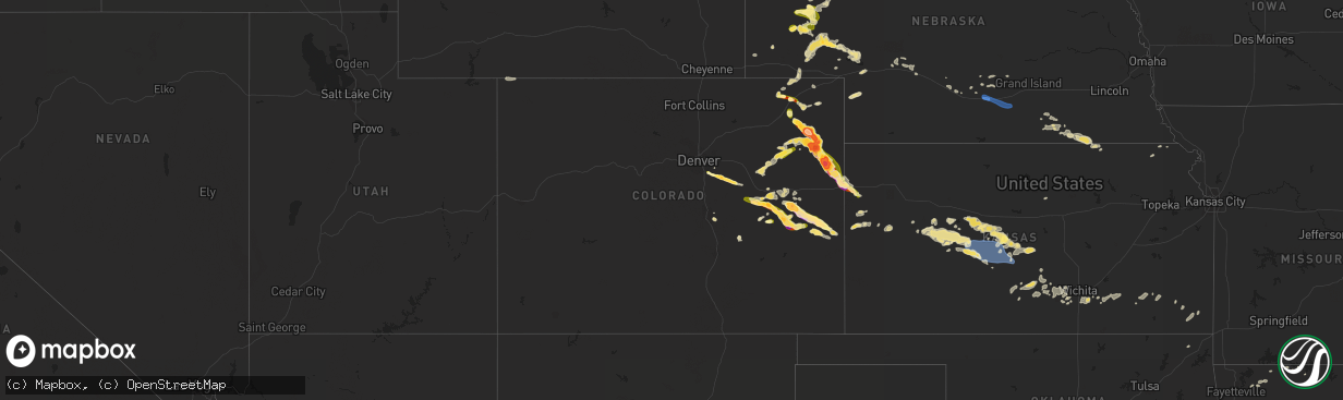
Hail Map in Colorado on August 8, 2023
The weather event in Colorado on August 8, 2023 includes Hail, Wind, and Tornado maps. 19 states and 553 cities were impacted and suffered possible damage. The total estimated number of properties impacted is 10,851.
Hail
Wind
Tornado
10,851
Estimated number of impacted properties by a 1.00" hail or larger3,843
Estimated number of impacted properties by a 1.75" hail or larger4,439
Estimated number of impacted properties by a 2.50" hail or largerStorm reports in Colorado
Colorado
| Date | Description |
|---|---|
| 08/08/20236:59 PM CDT | Report from mping: half dollar |
| 08/08/20236:48 PM CDT | A local report indicates 1.75 inch wind near 10 WSW Hugo |
| 08/08/20236:45 PM CDT | Up to golf ball hail observed. Power was out at the residence. |
| 08/08/20236:34 PM CDT | Delayed report via social media with photo of hailstones. Time estimated. |
| 08/08/20236:30 PM CDT | Delayed report via social media. Multi-vortex tornado reported roughly 7-8 miles southeast of yuma. Location approximate based on radar. Tornado has lifted prior to 5:5 |
| 08/08/20236:18 PM CDT | Hail was ongoing at the location. |
| 08/08/20236:17 PM CDT | L06. |
| 08/08/20236:17 PM CDT | Corrects previous hail report from 4 n sterling. L06. |
| 08/08/20236:16 PM CDT | Report from mping: quarter |
| 08/08/20236:15 PM CDT | Corrects previous hail report from 7 n abarr. Delayed report via social media with picture. Time estimated. |
| 08/08/20236:13 PM CDT | 5 power poles snapped along hwy 59. Time estimated. |
| 08/08/20236:08 PM CDT | A local report indicates 4.00 inch wind near 3 W Yuma |
| 08/08/20236:07 PM CDT | Report from mping: tea cup |
| 08/08/20236:07 PM CDT | A local report indicates 1.50 inch wind near 11 NNE Kutch |
| 08/08/20236:05 PM CDT | Report from mping: hen egg+ |
| 08/08/20236:02 PM CDT | Tornado on the ground estimated 3 miles west of the airport. Location estimated. |
| 08/08/20236:02 PM CDT | De175. |
| 08/08/20236:00 PM CDT | Pub state patrol. |
| 08/08/20236:00 PM CDT | Delayed report via social media. |
| 08/08/20236:00 PM CDT | Delayed report via social media with picture. Time estimated. |
| 08/08/20235:57 PM CDT | Wa298... Seen from yuma. |
| 08/08/20235:57 PM CDT | Garage was lifted off foundation anchoring and shifted. Garage doors imploded... And about 100f roof structure was lost. Other tree damage on farm suggested ef1 damag |
| 08/08/20235:55 PM CDT | Small barn flipped on its side. Estimated wind gust to 90 mph per damage indicator. Also minor shingle damage to manufactured home at this location. Time estimated by o |
| 08/08/20235:50 PM CDT | Corrects time based on radar. Report from 2 nw hyde. Wa298... Seen from yuma. |
| 08/08/20235:08 PM CDT | A local report indicates 1.75 inch wind near 6 S Burdett |
| 08/08/202312:57 AM CDT | Report via x. |
| 08/08/202312:51 AM CDT | Report from mping: quarter |
| 08/08/202312:40 AM CDT | Report from mping: half dollar |
| 08/08/202312:13 AM CDT | A local report indicates 1.00 inch wind near 2 NNE Parker |
| 08/07/202311:25 PM CDT | Estimated tennis ball sized hail breaking windows of home. |
| 08/07/202311:25 PM CDT | Baseball size hail broke numerous double paned windows in a home in extreme northwest cheyenne county. A few miles away... Quarter to golf ball size hail accumulated to |
| 08/07/202310:20 PM CDT | Hail observed at mm 447 on i-70. |
| 08/07/20238:27 PM CDT | Chaser reported ongoing stovepipe tornado. Chaser was located 21 miles nw of burlington. Location of report based on radar. |
| 08/07/20238:25 PM CDT | Partially condensed cone tornado now rain wrapped. Location estimated via radar. Chaser was 11 miles sw of idalia. |
| 08/07/20238:22 PM CDT | Hail measured at 5.25 inches fell on hwy 36. Time and location estimated. |
| 08/07/20238:22 PM CDT | Hail measured at 5.25 inches fell on hwy 36. Time and location estimated. |
| 08/07/20238:22 PM CDT | Corrects previous hail report from 8 wsw idalia. Hail measured at 5.25 inches fell on hwy 36. Time estimated. New lsr created with exact location stone was picked up. |
| 08/07/20238:16 PM CDT | Report from mping: ping pong ball |
| 08/07/20238:13 PM CDT | Report from mping: half dollar |
| 08/07/20238:11 PM CDT | Delayed report via social media. Brief condensed and uncondensed circulations roughly 7 miles ne of kirk from 7 to 7:15 pm mdt. Image taken at county rd 3 and r. Locati |
| 08/07/20238:10 PM CDT | Chaser sent video of ongoing tornado that was dissipated as of 7:13 pm. Video observed from roads t and 8. Time and location estimated via radar. |
| 08/07/20238:09 PM CDT | Report from mping: quarter |
| 08/07/20237:30 PM CDT | Ongoing tornado reported. Location roughly 10 miles nw of kirk. Location estimated via radar and report. |
| 08/07/20237:30 PM CDT | Storm chaser reported 3.5 inch to 4 inch hail near the intersection of highway 59 and county road 25 at approximately 6:30 pm mdt. |
| 08/07/20237:25 PM CDT | Storm chasers were 7 miles north of joes looking to the northwest. They commented they saw rope tornado for about a minute and a half... Emerging out of rain shaft. Pos |
| 08/07/20237:20 PM CDT | Report from mping: tennis ball |
| 08/07/20237:19 PM CDT | A local report indicates 60 MPH wind near 1 ESE Abarr |
| 08/07/20237:19 PM CDT | Tornado just touched down via chaser live feed. Location estimated via radar. |
| 08/07/20237:17 PM CDT | Report from mping: ping pong ball |
| 08/07/20237:06 PM CDT | Brief tornado lasted about 2 minutes |
All States Impacted by Hail Map on August 8, 2023
Cities Impacted by Hail Map on August 8, 2023
- Seymour, TX
- Mena, AR
- Enid, OK
- Fairmont, OK
- Garber, OK
- Covington, OK
- Lucien, OK
- Douglas, OK
- Perry, OK
- Hennessey, OK
- Dover, OK
- Mulhall, OK
- Marshall, OK
- Bison, OK
- Crescent, OK
- Kingfisher, OK
- Cashion, OK
- Guthrie, OK
- Orlando, OK
- Coyle, OK
- Waukomis, OK
- Fairhaven, MA
- Mattapoisett, MA
- Portland, AR
- Hamburg, AR
- Wilmot, AR
- Parkdale, AR
- Crossett, AR
- Eudora, AR
- Isola, MS
- Wilmar, AR
- Lake Village, AR
- Montrose, AR
- Dermott, AR
- Oak Grove, LA
- Jones, LA
- Monticello, AR
- Fountain Hill, AR
- International Falls, MN
- Kabetogama, MN
- Orr, MN
- Gary, MN
- Mahnomen, MN
- Bejou, MN
- Crane Lake, MN
- Sheridan, WY
- Angora, NE
- Alliance, NE
- Bridgeport, NE
- Bayard, NE
- Sterling, CO
- Otis, CO
- Akron, CO
- Byron, GA
- Warner Robins, GA
- Centerville, GA
- Fort Valley, GA
- Albany, GA
- Leary, GA
- Dawson, GA
- Bronwood, GA
- Leesburg, GA
- Shellman, GA
- Morgan, GA
- Sylvester, GA
- Warwick, GA
- Poulan, GA
- Oakfield, GA
- Ty Ty, GA
- Ashburn, GA
- Tifton, GA
- Doerun, GA
- Sumner, GA
- Chula, GA
- Omega, GA
- Baconton, GA
- Lenox, GA
- Hawley, MN
- Norman Park, GA
- Moultrie, GA
- Pavo, GA
- Berlin, GA
- Adel, GA
- Barney, GA
- Ellenton, GA
- Sparks, GA
- Hahira, GA
- Valdosta, GA
- Morven, GA
- Willacoochee, GA
- Ray City, GA
- Alapaha, GA
- Enigma, GA
- Nashville, GA
- Oshkosh, NE
- Lake Park, MN
- Broadwater, NE
- Rebecca, GA
- Ocilla, GA
- Sycamore, GA
- Fitzgerald, GA
- Douglas, GA
- Pearson, GA
- Lakeland, GA
- Broxton, GA
- Wray, GA
- West Green, GA
- Ambrose, GA
- Nicholls, GA
- Homerville, GA
- Axson, GA
- Lakeside, NE
- Yuma, CO
- Ellsworth, NE
- Millwood, GA
- Tucson, AZ
- Audubon, MN
- Troy, AL
- Goshen, AL
- Andersonville, GA
- Oglethorpe, GA
- Dry Branch, GA
- Maybell, CO
- Eastman, GA
- Perry, GA
- Milan, GA
- Chauncey, GA
- Borup, MN
- Union Springs, AL
- Gay, GA
- Molena, GA
- Concord, GA
- Fleming, CO
- Chambers, AZ
- Fosston, MN
- Georgetown, MN
- Frazee, MN
- Richland, GA
- Arabi, GA
- Lapine, AL
- Montrose, GA
- Danville, GA
- Eufaula, AL
- Green Valley, AZ
- Aragon, NM
- Rock Springs, WY
- Cochran, GA
- Montgomery, AL
- Lumpkin, GA
- Cordele, GA
- Columbia, AL
- Abbeville, AL
- Blakely, GA
- Shorterville, AL
- Mandeville, LA
- Covington, LA
- Hawkinsville, GA
- Camden, AL
- Pine Apple, AL
- Midway, AL
- Hurtsboro, AL
- Hitterdal, MN
- Hayneville, AL
- Hope Hull, AL
- Newton, AL
- Slocomb, AL
- Daleville, AL
- Dothan, AL
- Georgetown, GA
- Brantley, AL
- Glenwood, AL
- Glyndon, MN
- Bonaire, GA
- Jeffersonville, GA
- Abbeville, GA
- Rochert, MN
- Detroit Lakes, MN
- Osage, MN
- Pittsview, AL
- Grady, AL
- Ramer, AL
- Pompano Beach, FL
- Luverne, AL
- Rutledge, AL
- Pinehurst, GA
- Byromville, GA
- Ogema, MN
- Macon, GA
- Ulen, MN
- Hatchechubbee, AL
- Roberta, GA
- Dublin, GA
- Irwinton, GA
- Omaha, GA
- Felton, MN
- Smithville, GA
- Preston, GA
- Americus, GA
- Plains, GA
- Leslie, GA
- De Soto, GA
- Woodbury, GA
- Highland Home, AL
- Hardaway, AL
- Tuskegee, AL
- McRae Helena, GA
- Alamo, GA
- Bushnell, NE
- Morris, GA
- Cuthbert, GA
- Fitzpatrick, AL
- Rhine, GA
- Pineview, GA
- Forest Home, AL
- Callaway, MN
- Buena Vista, GA
- Montezuma, GA
- Marshallville, GA
- Newville, AL
- Iliff, CO
- Eckley, CO
- Simla, CO
- Matheson, CO
- Limon, CO
- Hugo, CO
- Karval, CO
- Gordon, NE
- Joes, CO
- Merriman, NE
- Martin, SD
- Kirk, CO
- Vernon, CO
- Idalia, CO
- Haswell, CO
- Kit Carson, CO
- Burlington, CO
- Kanorado, KS
- Goodland, KS
- Quitaque, TX
- Clarendon, TX
- Lakeview, TX
- Childress, TX
- Memphis, TX
- Hedley, TX
- Lelia Lake, TX
- Wellington, TX
- Quail, TX
- Turkey, TX
- Mclean, TX
- Shamrock, TX
- Quanah, TX
- Hollis, OK
- Dodson, TX
- Flagler, CO
- Kearney, NE
- Odessa, NE
- Minden, NE
- Heartwell, NE
- Crook, CO
- North Platte, NE
- Arriba, CO
- Socorro, NM
- Pleasanton, NE
- Baxley, GA
- Lyons, GA
- Padroni, CO
- Barnesville, MN
- Pelican Rapids, MN
- Ludowici, GA
- Colorado Springs, CO
- Sabin, MN
- Bingham, NE
- Rushville, NE
- Hay Springs, NE
- Hemingford, NE
- Sutherland, NE
- Hershey, NE
- Los Lunas, NM
- Peetz, CO
- Sidney, NE
- Woodrow, CO
- Deer Trail, CO
- Rothsay, MN
- Wolverton, MN
- Haxtun, CO
- Huachuca City, AZ
- Tombstone, AZ
- Vidalia, GA
- Manor, GA
- Waycross, GA
- Concho, AZ
- Riceboro, GA
- Midway, GA
- Lumber City, GA
- Moorhead, MN
- Lakeside, AZ
- Gurley, NE
- Lewellen, NE
- Tuthill, SD
- Reidsville, GA
- Glennville, GA
- Cobbtown, GA
- Riverdale, NE
- Nahunta, GA
- Harrisburg, NE
- Lisco, NE
- Boone, CO
- Yoder, CO
- Odum, GA
- Estancia, NM
- Nelson, NE
- Oak, NE
- Dalton, NE
- Lodgepole, NE
- Brunswick, GA
- Jesup, GA
- Benson, AZ
- Saint David, AZ
- Collins, GA
- Albuquerque, NM
- Pena Blanca, NM
- Puposky, MN
- East Dublin, GA
- Ashby, NE
- Marana, AZ
- Agate, CO
- Willcox, AZ
- Thomasville, GA
- Pembroke, GA
- Screven, GA
- Peralta, NM
- Fellsmere, FL
- Sahuarita, AZ
- Savannah, GA
- Fort Stewart, GA
- Claxton, GA
- Pima, AZ
- Edgar, NE
- Allenhurst, GA
- Hinesville, GA
- Sedona, AZ
- Coolidge, GA
- Show Low, AZ
- Bloomingdale, GA
- Clay Center, NE
- Hazlehurst, GA
- Amherst, NE
- Saint Johns, AZ
- Maxwell, NE
- Cleveland, ND
- Medina, ND
- Pingree, ND
- Woodworth, ND
- Twin City, GA
- Swainsboro, GA
- Metter, GA
- Anton, CO
- Lindon, CO
- Gibbon, NE
- Kenesaw, NE
- Gould, OK
- Vinson, OK
- Eldorado, OK
- Mangum, OK
- Duke, OK
- Parker, CO
- Cheyenne Wells, CO
- Elizabeth, CO
- Kiowa, CO
- Granite, OK
- Willow, OK
- Erick, OK
- Carter, OK
- Elk City, OK
- Sayre, OK
- Canute, OK
- Dill City, OK
- Sentinel, OK
- Lone Wolf, OK
- Blair, OK
- Olustee, OK
- Altus, OK
- Hobart, OK
- Roosevelt, OK
- Clinton, OK
- Foss, OK
- Rocky, OK
- Cordell, OK
- Gotebo, OK
- Corn, OK
- Bessie, OK
- Bennett, CO
- Ramah, CO
- Mountain View, OK
- Binger, OK
- Lookeba, OK
- Colony, OK
- Hydro, OK
- Carnegie, OK
- Gracemont, OK
- Fort Cobb, OK
- Anadarko, OK
- Weatherford, OK
- Minco, OK
- Hinton, OK
- Great Bend, KS
- Hoisington, KS
- Olmitz, KS
- Alexander, KS
- Burdett, KS
- Nekoma, KS
- Bazine, KS
- Otis, KS
- Larned, KS
- Pawnee Rock, KS
- Rush Center, KS
- Rozel, KS
- Ness City, KS
- La Crosse, KS
- Albert, KS
- Bison, KS
- St John, KS
- Hudson, KS
- Miller, NE
- Genoa, CO
- Grant, NE
- Venango, NE
- Carleton, NE
- Hazard, NE
- Crawford, NE
- McCracken, KS
- Hays, KS
- Sabetha, KS
- Lemoyne, NE
- Cozad, NE
- Eads, CO
- Arapahoe, CO
- Sheridan Lake, CO
- Deshler, NE
- Davenport, NE
- Hebron, NE
- Gilead, NE
- Fairbury, NE
- Hubbell, NE
- Reynolds, NE
- Endicott, NE
- Ellis, KS
- Morrowville, KS
- Winona, KS
- Ransom, KS
- Scott City, KS
- Leoti, KS
- Weskan, KS
- Wallace, KS
- Tribune, KS
- Sharon Springs, KS
- Overton, NE
- Hollenberg, KS
- Hanover, KS
- Lexington, NE
- Ogallala, NE
- Aurora, CO
- Fairfield, NE
- Littlefork, MN
- Wakeeney, KS
- Quinter, KS
- Healy, KS
- Pfeifer, KS
- Seibert, CO
- Elm Creek, NE
- Barnard, KS
- Ravenna, NE
- Winkelman, AZ
- Dighton, KS
- Washington, KS
- Morrill, KS
- Ong, NE
- Big Springs, NE
- Grinnell, KS
- Kingman, KS
- Pretty Prairie, KS
- Utica, KS
- Collyer, KS
- Thayer, KS
- Galesburg, KS
- Ellinwood, KS
- Viola, KS
- Clearwater, KS
- Yellville, AR
- Hiawatha, KS
- Arlington, KS
- Partridge, KS
- Hutchinson, KS
- Huntsville, AR
- Raymond, KS
- Lyons, KS
- Chase, KS
- Rose Hill, KS
- Derby, KS
- Russell, KS
- Liebenthal, KS
- Beeler, KS
- Brownell, KS
- Arnold, KS
- Berryville, AR
- Schoenchen, KS
- Claflin, KS
- Fall River, KS
- Howard, KS
- Ganado, AZ
- Conway Springs, KS
- Augusta, KS
- Turon, KS
- Cunningham, KS
- Douglass, KS
- Murdock, KS
- Stuart, NE
- Atkinson, NE
- Altoona, KS
- Benedict, KS
- Fredonia, KS
- Isabel, KS
- Goddard, KS
- Colwich, KS
- Andale, KS
- Chanute, KS
- Green Forest, AR
- Mulvane, KS
- Surrency, GA
- Newport, NE
- Cheney, KS
- Garden Plain, KS
- Bluejacket, OK
- Lead Hill, AR
- Harrison, AR
- Omaha, AR
- Hindsville, AR
- Leon, KS
- Atlanta, KS
- Latham, KS
- Oswego, KS
- McCune, KS
- Oronogo, MO
- Pratt, KS
- Iuka, KS
- Cherokee, KS
- Saint Paul, KS
- Parsons, KS
- Highlandville, MO
- Jasper, MO
- Mount Hope, KS
- Baudette, MN
- Williams, MN


