Hail Map in Maryland on July 29, 2023
The weather event in Maryland on July 29, 2023 includes Wind, Hail, and Tornado maps. 30 states and 1,258 cities were impacted and suffered possible damage. The total estimated number of properties impacted is 0.
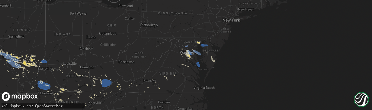
Wind
Hail
Tornado
0
Estimated number of impacted properties by a 1.00" hail or larger0
Estimated number of impacted properties by a 1.75" hail or larger0
Estimated number of impacted properties by a 2.50" hail or largerStorm reports in Maryland
Maryland
| Date | Description |
|---|---|
| 07/29/20236:54 PM CDT | Three reports of downed trees in the california area |
| 07/29/20236:44 PM CDT | Tree across cedar lane rd. Near blacksmith shop rd. |
| 07/29/20236:35 PM CDT | Large tree fell on a camper. Numerous trees down in the vicinity of crumpton and chesterville... And scattered across northern part of the county. Corrected time from p |
| 07/29/20236:32 PM CDT | Trees in power lines on deal island. |
| 07/29/20236:20 PM CDT | Trees down between westover and princess anne. |
| 07/29/20236:20 PM CDT | Large tree fell on a camper. Numerous trees down in the vicinity of crumpton and chesterville... And scattered across northern part of the county. |
| 07/29/20236:20 PM CDT | Trees and wires down... Scattered throughout kent county. |
| 07/29/20236:20 PM CDT | Six reports of trees and power poles down around chaptico to morganza |
| 07/29/20236:20 PM CDT | Delayed report. St. Mary's county em relayed reports of numerous trees down along thompson corner road... Mechanicsville road... And baptist church road between mechani |
| 07/29/20236:04 PM CDT | A local report indicates 80 MPH wind near 2 WSW Andrews |
| 07/29/20235:38 PM CDT | Delayed report. St. Mary's county em reported numerous trees and power lines downed along many roads south of mechanicsville. Time estimated from radar. |
| 07/29/20235:33 PM CDT | At least seven reports of downed trees in the area around mechanicsville and several miles north and east |
| 07/29/20235:30 PM CDT | St. Mary's county em reported a large tree downed near new market turner road and lockes hill road. Time estimated from radar. |
| 07/29/20235:26 PM CDT | Multiple trees down onto homes and cars in golden beach. |
| 07/29/20235:24 PM CDT | A local report indicates 61 MPH wind near 2 WSW Andrews |
| 07/29/20235:24 PM CDT | Tree down on maryland route 6 between four seasons court and flora corner road. |
| 07/29/20235:18 PM CDT | Numerous trees blew down along golden beach road and on northbound md-5 leonardtown road. |
| 07/29/20235:17 PM CDT | Tree on a house in cambridge. Trees on power lines and blocking roads across portions of the area. |
| 07/29/20235:03 PM CDT | Several large branches blown down on nobel and breeding road. Time estimated from radar. |
| 07/29/20234:58 PM CDT | Ripley road is impassable due to numerous trees reported down. |
| 07/29/20234:55 PM CDT | Multiple reports of trees down across hughesville. |
| 07/29/20234:50 PM CDT | Wxflow gauge at millington. |
| 07/29/20234:49 PM CDT | Wunderground station kmdtilgh14. |
| 07/29/20234:45 PM CDT | A wind gust of 54 knots |
| 07/29/20234:44 PM CDT | Wunderground station kmdmasse2. |
| 07/29/20234:40 PM CDT | Tree down on jefferys way in easton. Time estimated from radar. |
| 07/29/20234:38 PM CDT | Numerous large trees fell down onto houses on walleye court... Mark drive... And cottoneaster court. |
| 07/29/20234:38 PM CDT | Power lines and wires down on elm avenue and wayside avenue in easton. Time estimated from radar. |
| 07/29/20234:38 PM CDT | Trees down on baileys neck road southwest of easton. Time estimated from radar. |
| 07/29/20234:36 PM CDT | Numerous large trees blew down in the pomfret area... Including along billingsley road... Bennsville road... And cattle place. |
| 07/29/20234:35 PM CDT | Corrects previous tstm wnd dmg report from crumpton. Large tree fell on a camper. Numerous trees down in the vicinity of crumpton and chesterville... And scattered acro |
| 07/29/20234:35 PM CDT | Corrects previous tstm wnd dmg report from crumpton. Large tree fell on a camper. Numerous trees down in the vicinity of crumpton and chesterville... And scattered acro |
| 07/29/20234:34 PM CDT | Mesonet station md073 md-33 at knapps narrows drawbrid. |
| 07/29/20234:33 PM CDT | Wind gusts of up to 50 knots |
| 07/29/20234:33 PM CDT | Tree down on todds corner road. Time estimated from radar. |
| 07/29/20234:30 PM CDT | Cecil county 911 center reported a tree down along buds landing road. Time estimated from radar. |
| 07/29/20234:29 PM CDT | Wind gusts of up to 50 knots |
| 07/29/20234:26 PM CDT | Wind gust to 60 mph recorded by a weatherflow sensor in worton. |
| 07/29/20234:25 PM CDT | Corrects time of previous tstm wnd dmg report from worton. Trees and wires down... Scattered throughout kent county. |
| 07/29/20234:24 PM CDT | Wunderground station kmdmaryl25. |
| 07/29/20234:24 PM CDT | Wunderground station kmdwittm5. |
| 07/29/20234:24 PM CDT | Wunderground station kmdsteve76. |
| 07/29/20234:24 PM CDT | Wind gusts of up to 51 knots |
| 07/29/20234:24 PM CDT | Wunderground station kmdsteve76. |
| 07/29/20234:23 PM CDT | Trees and limbs down in kennedyville. Time estimated from radar. |
| 07/29/20234:21 PM CDT | Wxflow gauge at worton. |
| 07/29/20234:19 PM CDT | Tree down at kent island high school. Time estimated from radar. |
| 07/29/20234:19 PM CDT | Tree down at kent island high school. Time estimated from radar. |
| 07/29/20234:19 PM CDT | Tree down at kent island high school. Time estimated from radar. |
| 07/29/20234:18 PM CDT | Trees blew down on southbound md-210 indian head highway at md-228 berry road. |
| 07/29/20234:17 PM CDT | Trees and limbs down in still pond. Time estimated from radar. |
| 07/29/20234:06 PM CDT | Trees blew down on southbound i-95/i-495 capital beltway inner loop at exit 4b/md-414 saint barnabas road. |
| 07/29/20234:03 PM CDT | Trees blew down on southbound md-794 at md-408 mount zion marlboro road. |
| 07/29/20234:01 PM CDT | Trees blew down on eastbound md-4 pennsylvania avenue/stephanie roper highway at md-717 water street. |
| 07/29/20233:54 PM CDT | Trees blew down on eastbound md-178 generals highway prior to herald harbor road. |
| 07/29/20233:53 PM CDT | Trees blew down on northbound md-424 davidsonville road at us-50 john hanson highway. |
| 07/29/20233:52 PM CDT | Trees blew down on md-450 defense highway at pebblebrook court. |
| 07/29/20233:50 PM CDT | Trees blew down on us-40 pulaski highway at abingdon road. |
| 07/29/20233:45 PM CDT | Large trees blew down near the intersection of md-197 laurel-bowie road and old chapel road. |
| 07/29/20233:45 PM CDT | Public reports numerous downed trees in the takoma park and silver spring areas. Time estimated from radar. |
| 07/29/20233:45 PM CDT | Harford county 911 center reported numerous trees and power lines downed in the edgewood area. |
| 07/29/20233:43 PM CDT | A wind gust of 50 knots |
| 07/29/20233:39 PM CDT | Trees blew down onto southbound md-295 baltimore-washington parkway prior to md-193 greenbelt road. |
| 07/29/20233:39 PM CDT | Tree down on us route 1 at new cut road. |
| 07/29/20233:38 PM CDT | Large tree limbs snapped |
| 07/29/20233:33 PM CDT | Tree down on us route 1 at whiskey bottom road. |
| 07/29/20233:31 PM CDT | Numerous large trees and branches blew down near savage... Including on vollmerhausen road between the little patuxent river and savage guilford road... And along found |
| 07/29/20233:30 PM CDT | A wind gust of 53 knots |
| 07/29/20233:30 PM CDT | Montgomery county fire reported numerous people were displaced after trees fell onto multiple residences in the bethesda park condominiums in rockville. |
| 07/29/20233:30 PM CDT | Tree down onto a home in the 500 block of albany ave. In tacoma park... Md. |
| 07/29/20233:30 PM CDT | Delayed report. Montgomery county em relayed report of numerous trees down in the forest glen area. Time estimated from radar. |
| 07/29/20233:28 PM CDT | Trees blew down on us-1 washington boulevard north at corridor road. |
| 07/29/20233:28 PM CDT | Trees blew down on southbound us-29 columbia pike at exit 21a/southbound md-108 clarksville pike. |
| 07/29/20233:28 PM CDT | Montgomery county fire reported significant roof damage to a business along rockville pike and bou ave. |
| 07/29/20233:28 PM CDT | Tree down on maryland route 175 at us route 29. |
| 07/29/20233:28 PM CDT | Multiple large trees down onto structures near the 1220 block of charles road. |
| 07/29/20233:27 PM CDT | Trees blew down on eastbound md-614 goldsboro road at wedgewood road. |
| 07/29/20233:26 PM CDT | Trees blew down on eastbound md-190 river road at whittier boulevard. |
| 07/29/20233:25 PM CDT | Montgomery county fire reported a large tree downed onto two residences. Several people were trapped and had to be rescued. No injuries reported. |
| 07/29/20233:25 PM CDT | Delayed report. Trained spotter relayed report of numerous trees down in the columbia area along haprers farm rd... Cedar lane... And homewood rd. |
| 07/29/20233:24 PM CDT | Numerous trees down on clara barton pkwy. |
| 07/29/20233:24 PM CDT | Trees blew down on clara barton parkway at cabin john parkway. |
| 07/29/20233:23 PM CDT | Tree down onto a home in the 6000 block of cronwell dr. In bethesda... Md. |
| 07/29/20233:23 PM CDT | Multiple trees down onto powerlines near glen echo. |
| 07/29/20233:22 PM CDT | Trees blew down on md-355 rockville pike at i-495 capital beltway. |
| 07/29/20233:21 PM CDT | Trees blew down on southbound md-185 connecticut avenue at veirs mill road. |
| 07/29/20233:20 PM CDT | Montgomery county fire reported numerous downed trees along tilden laand in north bethesda. |
| 07/29/20233:19 PM CDT | Roof blown off of a commercial building with significant strucutural damage to the building. |
| 07/29/20233:19 PM CDT | Multiple large trees and power lines down on the north side of bethesda. One community had several trees down onto vehicles and onto porches of homes. |
| 07/29/20233:19 PM CDT | Delayed report. Mdot reported md-138 was closed between monkton road and wesley chapel road due to downed power lines on roadway. |
| 07/29/20233:17 PM CDT | Trees blew down on eastbound md-108 olney sandy spring road past prince philip drive. |
| 07/29/20233:15 PM CDT | Delayed report. Montgomery county em relayed report of numerous downed trees in the potomac area. Time estimated from radar. |
| 07/29/20233:10 PM CDT | Multiple trees... Powerlines... And transformers down along layhill rd. Between chester mill rd. And norbeck rd. |
| 07/29/20233:05 PM CDT | A wind gust of 60 knots |
| 07/29/20233:02 PM CDT | Trees blew down on md-355 frederick road at md-118 germantown road. |
| 07/29/20233:02 PM CDT | Delayed report. Montgomery county em relayed report of a tree downed onto a power pole along 22600 blk of wildcat road. |
| 07/29/20233:01 PM CDT | Large tree split in half on the 15200 block of montevideo road. |
| 07/29/20233:01 PM CDT | Mutliple trees down on gainford court. |
| 07/29/20233:01 PM CDT | Multiple trees down near montgomery village. |
| 07/28/20238:25 PM CDT | Tempest station at trinity church rd measured a peak wind gust of 60kt/69mph. |
| 07/28/20237:41 PM CDT | Tree down across point lookout rd. Near bauer rd. |
| 07/28/20237:22 PM CDT | Tree down blocking both lanes of happyland rd. |
| 07/28/20237:15 PM CDT | A wind gust of 52 knots |
| 07/28/20237:13 PM CDT | Wind gusts of up to 52 knots |
All States Impacted by Hail Map on July 29, 2023
Cities Impacted by Hail Map on July 29, 2023
- Waterloo, IA
- Winthrop, IA
- Independence, IA
- Jesup, IA
- Dunkerton, IA
- Rowley, IA
- Fairbank, IA
- Brandon, IA
- Mount Auburn, IA
- Walker, IA
- Vinton, IA
- La Porte City, IA
- Atkins, IA
- Cedar Rapids, IA
- Center Point, IA
- Shellsburg, IA
- Quasqueton, IA
- Fairfax, IA
- Palo, IA
- Urbana, IA
- Durango, IA
- Bernard, IA
- Hopkinton, IA
- Coggon, IA
- Worthington, IA
- Central City, IA
- Robins, IA
- Delhi, IA
- Manchester, IA
- Marion, IA
- Ryan, IA
- Langworthy, IA
- Springville, IA
- Monticello, IA
- Alburnett, IA
- Farley, IA
- Dubuque, IA
- Earlville, IA
- Epworth, IA
- Peosta, IA
- Toddville, IA
- Dyersville, IA
- Anamosa, IA
- Cascade, IA
- Masonville, IA
- Prairieburg, IA
- Delaware, IA
- Hiawatha, IA
- Akron, CO
- Yuma, CO
- Joes, CO
- Cope, CO
- Tucson, AZ
- Cleveland, GA
- Clermont, GA
- Dahlonega, GA
- Murrayville, GA
- Dawsonville, GA
- Cartersville, GA
- Sutton, NE
- McCool Junction, NE
- York, NE
- Henderson, NE
- Grafton, NE
- Guide Rock, NE
- Edgar, NE
- Nelson, NE
- Superior, NE
- Bradshaw, NE
- Clay Center, NE
- Saronville, NE
- Oak, NE
- Geneva, NE
- Ong, NE
- Fairmont, NE
- Stromsburg, NE
- Benedict, NE
- Waco, NE
- Davenport, NE
- Shickley, NE
- Deshler, NE
- Ruskin, NE
- Hardy, NE
- Ohiowa, NE
- Strang, NE
- Carleton, NE
- Exeter, NE
- Bruning, NE
- Milligan, NE
- Tobias, NE
- Western, NE
- Gresham, NE
- Milford, NE
- Seward, NE
- Utica, NE
- Dorchester, NE
- Beaver Crossing, NE
- Crete, NE
- Friend, NE
- Cordova, NE
- Hebron, NE
- Belvidere, NE
- Daykin, NE
- Fairbury, NE
- Wilber, NE
- Alexandria, NE
- Swanton, NE
- Plymouth, NE
- De Witt, NE
- Jansen, NE
- Goehner, NE
- Pleasant Dale, NE
- Denton, NE
- Martell, NE
- Hallam, NE
- Cortland, NE
- Clatonia, NE
- Beatrice, NE
- Pickrell, NE
- Gilead, NE
- Steele City, NE
- Odell, NE
- Diller, NE
- Endicott, NE
- Blue Springs, NE
- Wymore, NE
- Sprague, NE
- Roca, NE
- Firth, NE
- Filley, NE
- Adams, NE
- Hickman, NE
- Bennet, NE
- Liberty, NE
- Virginia, NE
- Panama, NE
- Lincoln, NE
- Crab Orchard, NE
- Tecumseh, NE
- Douglas, NE
- Sterling, NE
- Palmyra, NE
- Burr, NE
- Unadilla, NE
- Syracuse, NE
- Cook, NE
- Elk Creek, NE
- Lewiston, NE
- Steinauer, NE
- Burchard, NE
- Talmage, NE
- Johnson, NE
- Auburn, NE
- Table Rock, NE
- Humboldt, NE
- Brock, NE
- Pawnee City, NE
- Brownville, NE
- Julian, NE
- Du Bois, NE
- Peru, NE
- Nebraska City, NE
- Dawson, NE
- Stella, NE
- Nemaha, NE
- Salem, NE
- Verdon, NE
- Shubert, NE
- Falls City, NE
- Rock Port, MO
- Fairfax, MO
- Craig, MO
- Rulo, NE
- Mound City, MO
- Forest City, MO
- Hiawatha, KS
- Sabetha, KS
- Morrill, KS
- White Cloud, KS
- Maitland, MO
- Oregon, MO
- Fillmore, MO
- Saint Joseph, MO
- Robinson, KS
- Wathena, KS
- Highland, KS
- Amazonia, MO
- Savannah, MO
- Troy, KS
- Cosby, MO
- Elwood, KS
- Barneston, NE
- Easton, MO
- Stewartsville, MO
- Agency, MO
- Clarksdale, MO
- Helena, MO
- Rosendale, MO
- Union Star, MO
- Maysville, MO
- Amity, MO
- Gower, MO
- Faucett, MO
- Denton, KS
- Bendena, KS
- Rushville, MO
- Dearborn, MO
- De Kalb, MO
- Atchison, KS
- Weston, MO
- Leavenworth, KS
- Platte City, MO
- Camden Point, MO
- Osborn, MO
- Edgerton, MO
- Winston, MO
- Smithville, MO
- Weatherby, MO
- Cameron, MO
- Trimble, MO
- Plattsburg, MO
- Lathrop, MO
- Turney, MO
- Excelsior Springs, MO
- Kearney, MO
- Holt, MO
- Liberty, MO
- Kingston, MO
- Gallatin, MO
- Hamilton, MO
- Altamont, MO
- Kidder, MO
- Polo, MO
- Lawson, MO
- Rayville, MO
- Cowgill, MO
- Richmond, MO
- Hardin, MO
- Braymer, MO
- Norborne, MO
- Breckenridge, MO
- Ludlow, MO
- Jamesport, MO
- Carrollton, MO
- Dawn, MO
- Bogard, MO
- Lock Springs, MO
- Chillicothe, MO
- Mooresville, MO
- Utica, MO
- Tina, MO
- Hale, MO
- Brunswick, MO
- Triplett, MO
- De Witt, MO
- Bosworth, MO
- Sumner, MO
- Slater, MO
- Dalton, MO
- Miami, MO
- Meadville, MO
- Wheeling, MO
- Mendon, MO
- Salisbury, MO
- Keytesville, MO
- Glasgow, MO
- Chula, MO
- Brookfield, MO
- Rothville, MO
- Laclede, MO
- Marceline, MO
- Linneus, MO
- New Cambria, MO
- Bucklin, MO
- Armstrong, MO
- Fayette, MO
- Clifton Hill, MO
- Callao, MO
- Huntsville, MO
- Bevier, MO
- Excello, MO
- Higbee, MO
- Rocheport, MO
- Columbia, MO
- Harrisburg, MO
- Macon, MO
- Sturgeon, MO
- Moberly, MO
- Cairo, MO
- Clark, MO
- Ashland, MO
- Hallsville, MO
- Centralia, MO
- Jacksonville, MO
- Madison, MO
- Holliday, MO
- Freedom, NH
- Madison, NH
- Brownfield, ME
- Porter, ME
- Ashley, IL
- Mount Vernon, IL
- Dix, IL
- Marissa, IL
- Saint Libory, IL
- Mascoutah, IL
- Ewing, IL
- Belle Rive, IL
- Ina, IL
- Carmi, IL
- Enfield, IL
- Nashville, IL
- Hoyleton, IL
- Waltonville, IL
- Woodlawn, IL
- Whigham, GA
- Cairo, GA
- McLeansboro, IL
- Pelham, GA
- Bonnie, IL
- Du Bois, IL
- Dahlgren, IL
- Springerton, IL
- New Harmony, IN
- Hartville, MO
- Bradfordsville, KY
- Gravel Switch, KY
- Macedonia, IL
- Opdyke, IL
- Carrier Mills, IL
- Marion, IL
- Lenzburg, IL
- Addieville, IL
- Keenes, IL
- Polk, NE
- Centralia, IL
- Scheller, IL
- Walnut Hill, IL
- Okawville, IL
- Oakdale, IL
- Whittington, IL
- Wayne City, IL
- Fulton, MO
- Thompson, MO
- Paris, MO
- Rush Hill, MO
- Mexico, MO
- Kingdom City, MO
- Auxvasse, MO
- Perry, MO
- Santa Fe, MO
- Laddonia, MO
- Benton City, MO
- Goffstown, NH
- Manchester, NH
- Farber, MO
- Vandalia, MO
- Martinsburg, MO
- Williamsburg, MO
- Montgomery City, MO
- Steedman, MO
- Wellsville, MO
- Portland, MO
- Rhineland, MO
- New Florence, MO
- Middletown, MO
- Warrenton, MO
- Truxton, MO
- Jonesburg, MO
- Bellflower, MO
- High Hill, MO
- Hermann, MO
- Hawk Point, MO
- Troy, MO
- Wright City, MO
- Silex, MO
- Moscow Mills, MO
- Truesdale, MO
- Foristell, MO
- Busy, KY
- Bulan, KY
- Hyden, KY
- Hazard, KY
- Bonnyman, KY
- Wooton, KY
- Krypton, KY
- Hindman, KY
- Combs, KY
- Carrie, KY
- Delphia, KY
- Smilax, KY
- Linefork, KY
- Viper, KY
- Partridge, KY
- Cornettsville, KY
- Slemp, KY
- Happy, KY
- Neon, KY
- Deane, KY
- Seco, KY
- Vicco, KY
- Sassafras, KY
- Whitesburg, KY
- Letcher, KY
- Jenkins, KY
- Jeff, KY
- Millstone, KY
- Thornton, KY
- Yeaddiss, KY
- Eolia, KY
- Ermine, KY
- Jeremiah, KY
- Mayking, KY
- Benham, KY
- Premium, KY
- Pine Top, KY
- Mallie, KY
- Redfox, KY
- Scuddy, KY
- Cumberland, KY
- Lynch, KY
- Hallie, KY
- Blackey, KY
- Gordon, KY
- Roxana, KY
- Littcarr, KY
- Isom, KY
- Helton, KY
- Wendover, KY
- Evarts, KY
- Stinnett, KY
- Putney, KY
- Chappell, KY
- Baxter, KY
- Mozelle, KY
- Bledsoe, KY
- Big Laurel, KY
- Essie, KY
- Warbranch, KY
- Totz, KY
- Dwarf, KY
- Emmalena, KY
- Morrison, MO
- Bland, MO
- Mount Sterling, MO
- Owensville, MO
- Gerald, MO
- Washington, MO
- Leslie, MO
- Rosebud, MO
- Berger, MO
- New Haven, MO
- Union, MO
- Beaufort, MO
- Clarence, MO
- Boyds, MD
- Clarksburg, MD
- Damascus, MD
- Gaithersburg, MD
- Germantown, MD
- Mount Airy, MD
- Dickerson, MD
- Barnesville, MD
- Sullivan, MO
- Villa Ridge, MO
- Saint Clair, MO
- Saint Peters, MO
- Saint Charles, MO
- O'Fallon, MO
- Wentzville, MO
- Lake Saint Louis, MO
- Old Monroe, MO
- Maryland Heights, MO
- Saint Louis, MO
- Glen Echo, MD
- Potomac, MD
- Cabin John, MD
- Bethesda, MD
- Washington, DC
- Chevy Chase, MD
- Earth City, MO
- Hazelwood, MO
- Bridgeton, MO
- Florissant, MO
- Chesterfield, MO
- Saint Ann, MO
- Alexandria, VA
- Falls Church, VA
- Arlington, VA
- Annandale, VA
- McLean, VA
- Capitol Heights, MD
- Oxon Hill, MD
- Clinton, MD
- Suitland, MD
- Andrews Air Force Base, MD
- Upper Marlboro, MD
- Fort Washington, MD
- Temple Hills, MD
- District Heights, MD
- Naval Anacost Annex, DC
- Bowie, MD
- Annapolis, MD
- Edgewater, MD
- Gambrills, MD
- Odenton, MD
- Crownsville, MD
- Crofton, MD
- Davidsonville, MD
- Riva, MD
- Shady Side, MD
- Galesville, MD
- West River, MD
- Harwood, MD
- Fort Myer, VA
- Ballwin, MO
- East Saint Louis, IL
- Lovejoy, IL
- Madison, IL
- East Carondelet, IL
- Granite City, IL
- Venice, IL
- Fairview Heights, IL
- Lebanon, IL
- Belleville, IL
- O'Fallon, IL
- Troy, IL
- Dupo, IL
- Collinsville, IL
- Caseyville, IL
- Millstadt, IL
- Freeburg, IL
- Scott Air Force Base, IL
- Waterloo, IL
- Valmeyer, IL
- Columbia, IL
- Smithton, IL
- New Athens, IL
- Red Bud, IL
- Hecker, IL
- Flora, IL
- Clay City, IL
- Chestertown, MD
- Worton, MD
- Millington, MD
- Still Pond, MD
- Kennedyville, MD
- Stevensville, MD
- Claiborne, MD
- Mcdaniel, MD
- Wittman, MD
- Saint Michaels, MD
- Bozman, MD
- Sherwood, MD
- Royal Oak, MD
- Neavitt, MD
- New Baden, IL
- Trenton, IL
- Albers, IL
- Bartelso, IL
- Waynesville, NC
- Model, CO
- Aurora, MO
- Marionville, MO
- Galena, MD
- Massey, MD
- Clayton, DE
- Townsend, DE
- Crumpton, MD
- Chester, IL
- Walsh, IL
- Coulterville, IL
- Pinckneyville, IL
- Ellis Grove, IL
- Evansville, IL
- Steeleville, IL
- Du Quoin, IL
- Percy, IL
- Sparta, IL
- Tilden, IL
- Tamaroa, IL
- Cutler, IL
- Baldwin, IL
- Rehoboth Beach, DE
- Brooklyn, CT
- Marine, IL
- Edwardsville, IL
- Saint Jacob, IL
- Brussels, IL
- Golden Eagle, IL
- Sainte Genevieve, MO
- Fairfield, IL
- Girdler, KY
- Hinkle, KY
- Cannon, KY
- Barbourville, KY
- Rogersville, MO
- Albany, KY
- Byrdstown, TN
- Clanton, AL
- Jemison, AL
- Nokesville, VA
- Gainesville, VA
- Bristow, VA
- Bedford, NH
- New Bloomfield, MO
- Ashburn, VA
- Leesburg, VA
- Farmington, MO
- Forest, MS
- Allensville, KY
- Ceres, VA
- Glen Arm, MD
- Abingdon, MD
- Hydes, MD
- Phoenix, MD
- Kingsville, MD
- Gunpowder, MD
- Edgewood, MD
- Joppa, MD
- Nottingham, MD
- White Marsh, MD
- Upper Falls, MD
- Fallston, MD
- Fork, MD
- Baldwin, MD
- Perry Hall, MD
- Eidson, TN
- Rogersville, TN
- Sneedville, TN
- Pelahatchie, MS
- Pall Mall, TN
- Ten Mile, TN
- Kingston, TN
- Rockwood, TN
- Booneville, KY
- Ricetown, KY
- McKee, KY
- Port Tobacco, MD
- La Plata, MD
- Jackson, KY
- Carterville, IL
- Bluford, IL
- Iuka, IL
- Salem, IL
- Dante, VA
- Bee, VA
- Cleveland, VA
- Monticello, KY
- Springfield, TN
- Greenbrier, TN
- Vest, KY
- Rocky Top, TN
- Jacksboro, TN
- Caryville, TN
- Morton, MS
- Brandon, MS
- Cottontown, TN
- Cross Plains, TN
- New Tazewell, TN
- Sharps Chapel, TN
- Speedwell, TN
- Tebbetts, MO
- Bonnots Mill, MO
- Jefferson City, MO
- Hartsburg, MO
- Holts Summit, MO
- La Vergne, TN
- Mount Juliet, TN
- Lebanon, TN
- Hermitage, TN
- Crawford, TN
- Allred, TN
- Rickman, TN
- Grand Tower, IL
- Wolf Lake, IL
- Carlyle, IL
- Jackson, MO
- Portland, TN
- Westmoreland, TN
- Bethpage, TN
- Mulkeytown, IL
- Spickard, MO
- Kingman, AZ
- Hackberry, AZ
- La Follette, TN
- Scottsville, KY
- Adolphus, KY
- Duffield, VA
- Goodlettsville, TN
- Joelton, TN
- Whites Creek, TN
- Cape Girardeau, MO
- Mokane, MO
- Winfield, MO
- Castlewood, VA
- Lebanon, VA
- Somerset, KY
- Burnside, KY
- Millersville, MO
- Marble Hill, MO
- Thorsby, AL
- Saint Paul, VA
- Kyles Ford, TN
- Springfield, KY
- Lebanon, KY
- Johnston City, IL
- West Frankfort, IL
- Thompsonville, IL
- Pittsburg, IL
- Magee, MS
- Mendenhall, MS
- Alto Pass, IL
- Jakin, GA
- Donalsonville, GA
- Annville, KY
- Tyner, KY
- Knoxville, TN
- Heiskell, TN
- Arnold, MO
- Gray, KY
- Lake, MS
- Andersonville, TN
- Maynardville, TN
- Liberty, KY
- Pinola, MS
- Stanford, KY
- Crab Orchard, KY
- Birchleaf, VA
- Clinchco, VA
- Haysi, VA
- Glen Carbon, IL
- Verona, MO
- Christopher, IL
- Sesser, IL
- Benton, IL
- Royalton, IL
- Jamestown, TN
- Altenburg, MO
- Pulaski, MS
- Nashville, TN
- Bowman, ND
- Irvine, KY
- Alma, IL
- Laurel, MD
- Richmond, KY
- Atkins, VA
- Auburn, KY
- Jamestown, MO
- Centertown, MO
- Raton, NM
- Woodburn, KY
- Bowling Green, KY
- Johnsonville, IL
- Carbondale, IL
- Newark, DE
- Woodstown, NJ
- Bear, DE
- New Castle, DE
- Pennsville, NJ
- Salem, NJ
- Xenia, IL
- Hendersonville, TN
- White House, TN
- Lily, KY
- London, KY
- Corbin, KY
- Burkesville, KY
- Tompkinsville, KY
- Columbiana, AL
- Shelby, AL
- Versailles, MO
- Walsenburg, CO
- Lorton, VA
- Fort Belvoir, VA
- Crane, MO
- Springfield, VA
- Elkville, IL
- Parksville, KY
- White Plains, MD
- Waldorf, MD
- Max Meadows, VA
- Draper, VA
- Harriman, TN
- Nicholasville, KY
- Russellville, TN
- Whitesburg, TN
- Accokeek, MD
- Batchtown, IL
- Foley, MO
- Harrogate, TN
- Tazewell, TN
- Breese, IL
- Aviston, IL
- Germantown, IL
- Livingston, TN
- Mooresburg, TN
- Maryville, IL
- West Blocton, AL
- Alvaton, KY
- Fountain Run, KY
- Franklin, KY
- Billings, MO
- Manchester, KY
- Hiram, ME
- Sedalia, CO
- Ashford, AL
- Thaxton, VA
- Geff, IL
- Rinard, IL
- Cisne, IL
- Sims, IL
- Hilham, TN
- Allons, TN
- Ava, IL
- Campbell Hill, IL
- Burfordville, MO
- Fairfax, VA
- Bryans Road, MD
- Vienna, VA
- Clifton, VA
- Great Falls, VA
- Burke, VA
- Dunn Loring, VA
- Woodbridge, VA
- Fairfax Station, VA
- Indian Head, MD
- Weogufka, AL
- Phenix City, AL
- Mountain Grove, MO
- Stuart, VA
- Galatia, IL
- Carthage, MO
- Jasper, MO
- Golden City, MO
- Surgoinsville, TN
- Gate City, VA
- Church Hill, TN
- Abingdon, VA
- Junction City, KY
- Kite, KY
- Topmost, KY
- Greenback, TN
- Maryville, TN
- Herrin, IL
- Energy, IL
- Windsor, KY
- Philadelphia, TN
- Wallins Creek, KY
- Harlan, KY
- Gordon, AL
- Jamestown, KY
- Russell Springs, KY
- Barnhill, IL
- Bristol, VA
- Sextons Creek, KY
- Clarksville, TN
- Mount Airy, NC
- West Alton, MO
- Monroe, TN
- Buckhorn, KY
- Sizerock, KY
- Thousandsticks, KY
- Bear Branch, KY
- Oneida, KY
- Glade Valley, NC
- Gamaliel, KY
- Freistatt, MO
- Mill Shoals, IL
- Crossville, IL
- Burnt Prairie, IL
- Norwood, MO
- Ava, MO
- Anna, IL
- Lake George, CO
- Festus, MO
- Mount Vernon, KY
- Berea, KY
- Sentinel Butte, ND
- Beach, ND
- Fairfield, ND
- Ludlow, SD
- East Bridgewater, MA
- Brockton, MA
- South Easton, MA
- West Bridgewater, MA
- Sand Coulee, MT
- Belt, MT
- Great Falls, MT
- Mount Carmel, IL
- Patoka, IN
- Owensville, IN
- Hazleton, IN
- Princeton, IN
- Francisco, IN
- Decker, IN
- Fort Branch, IN
- Fredonia, KY
- Princeton, KY
- Dawson Springs, KY
- Gainesville, MO
- Brixey, MO
- Squires, MO
- Noble, MO
- Zanoni, MO
- Wasola, MO
- Thornfield, MO
- Hardenville, MO
- Crofton, KY
- Saint Charles, KY
- White Plains, KY
- Cerulean, KY
- Hopkinsville, KY
- Rockvale, CO
- Canon City, CO
- Wetmore, CO
- Florence, CO
- Orchard, CO
- Grassy Butte, ND
- Killdeer, ND
- Dunn Center, ND
- Medora, ND
- Belfield, ND
- New England, ND
- Amidon, ND
- Rhame, ND
- Geyser, MT
- Geraldine, MT
- Highwood, MT
- Elkton, KY
- Pembroke, KY
- Eddyville, KY
- Herndon, KY
- Trenton, KY
- Cadiz, KY
- Oak Grove, KY
- Gracey, KY
- Solomons, MD
- Lexington Park, MD
- Great Mills, MD
- Callaway, MD
- California, MD
- Patuxent River, MD
- Saint Inigoes, MD
- Drayden, MD
- Ridge, MD
- Dameron, MD
- Valley Lee, MD
- Scotland, MD
- Park Hall, MD
- Lusby, MD
- Bennett, CO
- Halliday, ND
- Scranton, ND
- Reva, SD
- Prairie City, SD
- Mud Butte, SD
- Faith, SD
- Buffalo, SD
- Newell, SD
- Enning, SD
- Union Center, SD
- White Owl, SD
- Moccasin, MT
- Moore, MT
- Lewistown, MT
- Hobson, MT
- Grass Range, MT
- Wall, SD
- Howes, SD
- Wasta, SD
- Forest Grove, MT
- Winnett, MT
- Quinn, SD
- Philip, SD
- Colorado City, CO
- Penrose, CO
- Pueblo, CO
- Beulah, CO
- Rye, CO
- Avondale, CO
- Walnut Ridge, AR
- Beech Grove, AR
- Bono, AR
- Ararat, NC
- Dobson, NC
- Oak Ridge, TN
- Union Star, KY
- Lynch Station, VA
- Irvington, KY
- Pamplin, VA
- Appomattox, VA
- Marion, NC
- Denton, MT
- Statesville, NC
- Marietta, SC
- Cleveland, SC
- Cumberland Furnace, TN
- Cumberland City, TN
- Vanleer, TN
- Boston, KY
- Lebanon Junction, KY
- Shepherdsville, KY
- Dillwyn, VA
- Fordland, MO
- Bruner, MO
- Lucedale, MS
- Thayer, MO
- Mammoth Spring, AR
- Koshkonong, MO
- Sonoita, AZ
- Vail, AZ
- Rousseau, KY
- Springfield, MO
- West Plains, MO
- Hurt, VA
- Penhook, VA
- Union Hall, VA
- Sandy Level, VA
- Caret, VA
- Guffey, CO
- Buena Vista, GA
- Americus, GA
- Plains, GA
- Shellman, GA
- Ellaville, GA
- Chestnut Mound, TN
- Elmwood, TN
- Georgetown, DE
- Elberfeld, IN
- Lynnville, IN
- Oakland City, IN
- Chatham, VA
- Keeling, VA
- Sparta, MO
- Ozark, MO
- Chadwick, MO
- Oldfield, MO
- Sturgis, KY
- Norris, TN
- Gretna, VA
- Elkin, NC
- Columbia, AL
- Headland, AL
- Webb, AL
- East Bend, NC
- Higden, AR
- Bridgeville, DE
- Seaford, DE
- Edgemont, AR
- Shirley, AR
- Hustle, VA
- Port Royal, VA
- Dale, IN
- Lancaster, KY
- Batesville, AR
- Marcella, AR
- Locust Grove, AR
- Kinmundy, IL
- Ferrum, VA
- Mountain Home, AR
- Lynchburg, MO
- Monett, MO
- Mount Vernon, MO
- Camden, MS
- Williamsburg, KY
- Doniphan, MO
- Gatewood, MO
- Preston, GA
- Richland, GA
- Weston, GA
- Graff, MO
- Boonville, NC
- Dewey, AZ
- Prescott Valley, AZ
- Reliance, TN
- Aurora, NE
- Tiptonville, TN
- Ridgely, TN
- Bryantown, MD
- Equality, IL
- Harrisburg, IL
- Kell, IL
- Junction, IL
- Louisville, IL
- Noble, IL
- Honaker, VA
- Chandler, IN
- Evansville, IN
- Calvert City, KY
- Mistletoe, KY
- Buckingham, VA
- Scottsville, VA
- Howardsville, VA
- Salem, KY
- Siloam, NC
- Irvington, IL
- Richview, IL
- Harned, KY
- Garfield, KY
- Vernon Hill, VA
- Java, VA
- Pocahontas, AR
- Golden Gate, IL
- Occoquan, VA
- Pomfret, MD
- Philpot, KY
- Grandview, IN
- Lewisport, KY
- Maceo, KY
- Opelika, AL
- Salem, AL
- Pippa Passes, KY
- Bone Gap, IL
- Albion, IL
- Texico, IL
- Seale, AL
- Warsaw, VA
- Hardinsburg, KY
- Webster, KY
- Thurmond, NC
- Roaring Gap, NC
- Haubstadt, IN
- Oakman, AL
- Sparta, TN
- Mayfield, KY
- Stearns, KY
- Pinnacle, NC
- Millsboro, DE
- Showell, MD
- Frankford, DE
- Delmar, DE
- Whaleyville, MD
- Willards, MD
- Laurel, DE
- Bishopville, MD
- Berlin, MD
- Loretto, KY
- Altha, FL
- Fountain, FL
- Canton, MS
- Dawson, GA
- State Road, NC
- Cynthiana, IN
- Stephensport, KY
- Marbury, MD
- Bunnell, FL
- Antioch, TN
- Mauckport, IN
- Central, IN
- Battletown, KY
- Columbus, NC
- Mill Spring, NC
- Cartersville, VA
- Cumberland, VA
- Powhatan, VA
- Buncombe, IL
- Gladstone, VA
- Bradleyville, MO
- Garrison, MO
- Sandgap, KY
- Nixa, MO
- Denton, MD
- Lake City, AR
- Woodford, VA
- Spotsylvania, VA
- Fredericksburg, VA
- Ellery, IL
- Henry, VA
- East Flat Rock, NC
- Flat Rock, NC
- Hendersonville, NC
- Bowersville, GA
- Hartwell, GA
- Mountain View, AR
- Benton, KY
- Symsonia, KY
- Huddleston, VA
- Kadoka, SD
- Ingomar, MT
- Carthage, TN
- Winifred, MT
- Berthold, ND
- Des Lacs, ND
- Matheson, CO
- Reeder, ND
- Cunningham, TN
- Stanley, ND
- Calhan, CO
- Tecumseh, MO
- Zahl, ND
- Seymour, MO
- Plaza, ND
- Grenora, ND
- Long Valley, SD
- Fairburn, GA
- White River, SD
- Palermo, ND
- Cobden, IL
- Makanda, IL
- Clarkridge, AR
- Corydon, IN
- Decatur, GA
- Ellenwood, GA
- Mansfield, MO
- Browns, IL
- Ross, ND
- Wilder, TN
- Macon, GA
- Wanblee, SD
- Oak Ridge, MO
- Atlanta, GA
- Smyrna, GA
- Marietta, GA
- Parshall, ND
- Garrison, ND
- Roseglen, ND
- Clinton, TN
- Marshfield, MO
- Strafford, MO
- Naylor, MO
- Hinsdale, MT
- Richland, MT
- Opheim, MT
- Peerless, MT
- Larslan, MT
- Glentana, MT
- Scobey, MT
- Wolf Point, MT
- Frazer, MT
- Poplar, MT
- Brockton, MT
- Flaxville, MT
- Homestead, MT
- Medicine Lake, MT
- Froid, MT
- Richardton, ND
- Hebron, ND
- New Leipzig, ND
- Glen Ullin, ND
- Elgin, ND
- Carson, ND
- Dagmar, MT
- Antelope, MT
- Reserve, MT
- Musselshell, MT
- Wood River, NE
- Williston, ND
- Bainville, MT
- Westby, MT
- Benton, TN
- Vonore, TN
- Savannah, TN
- Prim, AR
- Almont, ND
- New Salem, ND
- Taylor, ND
- Flasher, ND


