Hail Map in Maryland on July 28, 2023
The weather event in Maryland on July 28, 2023 includes Wind, Hail, and Tornado maps. 29 states and 1,894 cities were impacted and suffered possible damage. The total estimated number of properties impacted is 43.
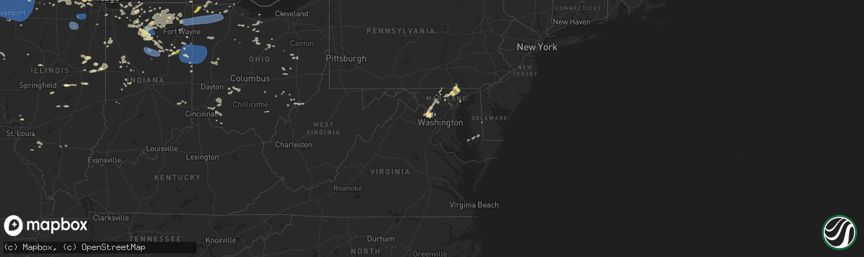
Wind
Hail
Tornado
43
Estimated number of impacted properties by a 1.00" hail or larger0
Estimated number of impacted properties by a 1.75" hail or larger0
Estimated number of impacted properties by a 2.50" hail or largerStorm reports in Maryland
Maryland
| Date | Description |
|---|---|
| 07/28/20236:50 PM CDT | Hundreds of trees blew down around pylesville and norrisville. Trees blew down onto a house in the 1900 block of neal road. Numerous trees blew down along md-136 harkin |
| 07/28/20236:50 PM CDT | Dozens of trees... Branches and wires blew down around bel air. |
| 07/28/20236:50 PM CDT | Numerous trees... Branches and wires blew down around joppa. |
| 07/28/20236:45 PM CDT | Numerous trees blew down around kingsville and pleasant furnace... Including one onto a car in the 800 block of petem road. |
| 07/28/20236:40 PM CDT | There were several calls for trees... Branches and wires down in the city of baltimore. |
| 07/28/20236:40 PM CDT | Dozens of trees and wires blew down around fallston and baldwin... Including trees onto houses in the 2800 block of greene road. |
| 07/28/20236:30 PM CDT | Numerous trees downed in pikesville... Garrison... Chestnut ridge... Brooklandville... Some onto homes and roads. |
| 07/28/20236:26 PM CDT | Trees blew down along md-146 dulaney valley road between md-131 east seminary avenue and valley court road. |
| 07/28/20236:20 PM CDT | Trees blew down on i-83 near exit 24/belfast road. |
| 07/28/20236:20 PM CDT | Trees blew down on southbound i-83 near exit 18/md-943 warren road. Numerous trees blew down along md-25 falls road near greenway road. |
| 07/28/20236:17 PM CDT | Numerous trees blew down along md-25 falls road near shawan road. |
| 07/28/20236:15 PM CDT | Several trees and wires blew down in central howard county... Including along carroll mill road near folly quarter road where trees fell on wires cracking a pole. |
| 07/28/20236:11 PM CDT | Dozens of trees down on houses and cars in reisterstown. |
| 07/28/20236:01 PM CDT | Tree onto a house in the 200 block of east main street. |
| 07/28/20235:57 PM CDT | Trees down blocking parkland dr... 1300 block northbound |
| 07/28/20235:52 PM CDT | Metro rail service suspended due to downed tree. |
| 07/28/20235:50 PM CDT | Numerous trees and wires blew down around winfield. |
| 07/28/20235:50 PM CDT | Numerous trees blew down in the 600 block of conaway lane. |
| 07/28/20235:50 PM CDT | Numerous trees and wires and some utility poles were blown down in the bethesda/chevy chase area. |
| 07/28/20235:50 PM CDT | Multiple trees blew down around silver spring... Including one onto a car on gannon road. |
| 07/28/20235:48 PM CDT | Trees and wires down over md 27... |
| 07/28/20235:47 PM CDT | Trees blew down near marston and new windsor... Including a large tree blocking sams creek road in the 2700 block. |
| 07/28/20235:40 PM CDT | Numerous trees blew down along md-27 ridge road near and north of west falls road. |
| 07/28/20235:40 PM CDT | Numerous trees blew down along md-27 ridge road near and north of west falls road. Trees blew down along md-26 liberty road near woodbine road. |
| 07/28/20235:40 PM CDT | There were a couple dozen reports of trees and wires blown down in the mount airy area. |
| 07/28/20235:36 PM CDT | Numerous trees and wires blew down in the rockville and potomac area... Including along arctic avenue... Democracy boulevard near falls road... Montrose road... Copley |
| 07/28/20235:30 PM CDT | Trees and wires blew down along md-26 liberty road. |
| 07/28/20235:23 PM CDT | Trees and wires blew down along old annapolis road. |
| 07/28/20235:20 PM CDT | Dozens of trees and wires blew down around gaithersburg and germantown... Including along brink road... Goshen road... Mid-county highway... Montgomery village avenue.. |
| 07/28/20235:15 PM CDT | Numerous trees blew down in poolesville... With several snapped in the 17700 block of doctor walling road. Trees and wires blew down near the intersection of md-28 darn |
| 07/28/20235:10 PM CDT | Trees blew down near the intersection of discovery boulevard and stauffer road. |
| 07/28/20235:09 PM CDT | Trees and wires blew down near the intersection of baltimore road and bells lane. |
| 07/28/20235:00 PM CDT | Several trees and wires blew down near myersville... Including along harmony road near md-17 wolfsville road. |
| 07/28/20234:37 PM CDT | Several trees and wires blew down around sharpsburg and antietam... Including along harpers ferry road. |
| 07/28/20238:36 AM CDT | Tree down in stevensville per 911 call center. Time estimated from radar. |
| 07/27/202310:57 PM CDT | Large tree branch down per 911 call center. Time estimated from radar. |
| 07/27/20238:36 PM CDT | Corrects time on previous tstm wnd dmg report from stevensville. Tree down in stevensville per 911 call center. Time estimated from radar. |
| 07/27/20238:25 PM CDT | Trees blew down on md-373 accokeek road near bealle hill road. |
| 07/27/20237:35 PM CDT | Several trees... Branches and wires blew down around elkton. |
| 07/27/20237:26 PM CDT | Multiple trees down in still pond per 911 call center. Time estimated from radar. |
| 07/27/20237:24 PM CDT | Trees and branches blew down on md-295 baltimore-washington parkway near md-197 laurel-bowie road. |
| 07/27/20237:24 PM CDT | Tree down in betterton per 911 center. Time estimated from radar. |
| 07/27/20237:21 PM CDT | Tree down at 193 and stadium drive. |
| 07/27/20237:20 PM CDT | Several trees... Branches and wires blew down around north east. |
| 07/27/20237:20 PM CDT | Trees blew down near the intersection of md-193 greenbelt road and md-201 kenilworth avenue. |
| 07/27/20237:20 PM CDT | Trees blew down on southbound md-295 baltimore-washington parkway near md-410 riverdale road. |
| 07/27/20237:15 PM CDT | Several trees... Branches and wires blew down around perryville. |
| 07/27/20237:10 PM CDT | Several trees... Branches and wires blew down in havre de grace. |
All States Impacted by Hail Map on July 28, 2023
Cities Impacted by Hail Map on July 28, 2023
- Homestead, FL
- Miami, FL
- Jeffersonville, KY
- Mount Sterling, KY
- Augusta, KY
- Brooksville, KY
- Morehead, KY
- Van Buren, IN
- Marion, IN
- Sharpsburg, KY
- Owingsville, KY
- Bloomingburg, OH
- Marathon, WI
- Jeffersonville, OH
- West Liberty, KY
- Georgetown, OH
- Maysville, KY
- Dover, KY
- Sugar Grove, OH
- Mount Orab, OH
- La Fontaine, IN
- Kokomo, IN
- Ewing, KY
- Flemingsburg, KY
- Hillsboro, KY
- Wallingford, KY
- Hamersville, OH
- Bethel, OH
- Germantown, KY
- Midland, OH
- Blanchester, OH
- Sidney, OH
- Pemberton, OH
- Port Jefferson, OH
- Waynesville, OH
- Oregonia, OH
- Morrow, OH
- Wilmington, OH
- Clarksville, OH
- Cory, IN
- Jackson Center, OH
- Lewistown, OH
- Quincy, OH
- London, OH
- Mount Sterling, OH
- South Solon, OH
- Washington Court House, OH
- Salt Lick, KY
- Goshen, OH
- Loveland, OH
- Cincinnati, OH
- Williamsburg, OH
- Fayetteville, OH
- Batavia, OH
- Gadsden, AL
- Foster, KY
- Rapid City, SD
- Cheyenne, WY
- Fe Warren Afb, WY
- Carr, CO
- Nunn, CO
- Superior, NE
- Nelson, NE
- Hardy, NE
- Ault, CO
- Ruskin, NE
- Saint Paul, MN
- Republic, KS
- Mankato, KS
- Webber, KS
- Sterling, VA
- Ashburn, VA
- Poolesville, MD
- Belleville, KS
- Courtland, KS
- Nickerson, NE
- Hooper, NE
- Fremont, NE
- Arlington, NE
- Hampton, MN
- Hastings, MN
- Valley, NE
- Scandia, KS
- Chapman, NE
- Grand Island, NE
- Phillips, NE
- Aurora, NE
- Bennington, NE
- Elkhorn, NE
- Alden, IA
- Dows, IA
- Galt, IA
- Omaha, NE
- New Auburn, WI
- Bloomer, WI
- Cannon Falls, MN
- Boys Town, NE
- Marquette, NE
- Giltner, NE
- Sutton, NE
- Harvard, NE
- Saronville, NE
- Beloit, KS
- Jewell, KS
- Belgrade, MT
- Bozeman, MT
- Wilsall, MT
- White Sulphur Springs, MT
- Boulder, CO
- Longmont, CO
- Lagrange, WY
- Iowa Falls, IA
- Geneva, NE
- Ong, NE
- Edgar, NE
- Shickley, NE
- Geneva, IA
- Hampton, IA
- Bradford, IA
- Ackley, IA
- Aplington, IA
- Wellsburg, IA
- Holland, IA
- Parkersburg, IA
- Steamboat Rock, IA
- Grundy Center, IA
- Northport, AL
- Sandy Hook, KY
- Butte, MT
- Selma, AL
- Waverly, WV
- Williamstown, WV
- Parkersburg, WV
- Woodland Park, CO
- Ripley, WV
- Hamden, OH
- Burns, WY
- Medford, WI
- Concord, PA
- Doylesburg, PA
- Southside, WV
- Leon, WV
- Haddam, KS
- Little River, AL
- Elbert, CO
- Gay, WV
- Foreston, MN
- Milaca, MN
- Scandinavia, WI
- Iola, WI
- Amherst Junction, WI
- Prescott, AZ
- Foley, MN
- Pierz, MN
- Rice, MN
- Royalton, MN
- Waynesboro, MS
- Winchester, VA
- Clear Brook, VA
- Tuscaloosa, AL
- Duncanville, AL
- Greenwood, WI
- Loyal, WI
- Vermillion, MN
- Cleveland, GA
- Thomasville, AL
- Mapleton Depot, PA
- Seligman, AZ
- Ogdensburg, WI
- Nelsonville, WI
- Winfield, AL
- Wirtz, VA
- Boones Mill, VA
- Stevens Point, WI
- Custer, WI
- Manawa, WI
- Jamestown, KS
- Norway, KS
- Sweet Water, AL
- Elkfork, KY
- Glen Elder, KS
- Camden, AL
- Pine Apple, AL
- Little Hocking, OH
- Coolville, OH
- Cutler, OH
- Quitman, MS
- Adamsville, AL
- Hurricane, WV
- Scott Depot, WV
- Bunker Hill, WV
- Kearneysville, WV
- Inwood, WV
- Hillsdale, WY
- Sautee Nacoochee, GA
- Ferrum, VA
- Henry, VA
- Flat Rock, MI
- Kiowa, CO
- Henderson, NE
- Martha, KY
- Jackson, AL
- Saint Paul Park, MN
- Minneapolis, MN
- Burnsville, MN
- Farmington, MN
- Cottage Grove, MN
- Inver Grove Heights, MN
- Rosemount, MN
- New Straitsville, OH
- Junction City, OH
- Logan, OH
- Alderson, WV
- Summersville, WV
- Great Falls, VA
- Potomac, MD
- Germantown, MD
- Leesburg, VA
- Herndon, VA
- Isonville, KY
- Cairo, WV
- Cottondale, AL
- Biglerville, PA
- Gettysburg, PA
- Aspers, PA
- Campton, KY
- Beattyville, KY
- Big Springs, WV
- Big Bend, WV
- Purlear, NC
- West Jefferson, NC
- Millers Creek, NC
- Sunburg, MN
- Murray City, OH
- Glouster, OH
- Milton, WV
- Ona, WV
- Vienna, WV
- Marietta, OH
- Belpre, OH
- Memphis, MI
- Allenton, MI
- Winslow, NE
- Shippensburg, PA
- Waynesboro, PA
- Chambersburg, PA
- Fayetteville, PA
- Jachin, AL
- Ward, AL
- Keaton, KY
- Flatgap, KY
- Rockhill Furnace, PA
- Shirleysburg, PA
- Orbisonia, PA
- Shenandoah Junction, WV
- Shepherdstown, WV
- Harpers Ferry, WV
- Petroleum, WV
- Agenda, KS
- Gainesville, GA
- Murrayville, GA
- Malta, OH
- Saint Marys, WV
- Newport, OH
- Oak, NE
- Williamsburg, PA
- Dawsonville, GA
- Cotopaxi, CO
- Jackson, KY
- Pine Ridge, KY
- Rogers, KY
- Ranson, WV
- Charles Town, WV
- Washington, VA
- Bentonville, VA
- Ponderosa, NM
- Attalla, AL
- Fleming, OH
- Waterford, OH
- White Post, VA
- Boyce, VA
- Hayden, AL
- Cleveland, AL
- Whitehall, MT
- Central City, CO
- Black Hawk, CO
- Northfork, WV
- Switchback, WV
- Elkhorn, WV
- Glen Fork, WV
- Ravencliff, WV
- Harrisville, WV
- Berea, WV
- Auburn, WV
- Pounding Mill, VA
- Nederland, CO
- Mount Nebo, WV
- Tryon, NC
- Easley, SC
- Pickens, SC
- Vincent, OH
- Burr Oak, KS
- Concordia, KS
- Dickerson, MD
- Barnesville, MD
- Ijamsville, MD
- Damascus, MD
- Clarksburg, MD
- Mount Airy, MD
- Monrovia, MD
- Beallsville, MD
- Boyds, MD
- Wellston, OH
- Stockport, OH
- Helen, GA
- Golden, CO
- Rollinsville, CO
- Clanton, AL
- Jemison, AL
- New Milton, WV
- Troy, WV
- Coxs Mills, WV
- Jefferson, NC
- Woodville, VA
- Castleton, VA
- Clermont, GA
- Ames, NE
- New Baltimore, MI
- Macomb, MI
- McIntosh, AL
- Tibbie, AL
- Gainestown, AL
- Hico, WV
- Newland, NC
- Pennock, MN
- Murdock, MN
- Amherst, WI
- Oak Park, MN
- Waverly, IA
- Tripoli, IA
- Readlyn, IA
- Denver, IA
- Fennimore, WI
- Stitzer, WI
- Stetsonville, WI
- Athens, WI
- Livingston, WI
- Platteville, WI
- Belmont, WI
- Rewey, WI
- Mineral Point, WI
- Strang, NE
- Bruning, NE
- Carleton, NE
- Davenport, NE
- Simpson, KS
- Glasco, KS
- Barnard, KS
- Lincoln, NE
- Darlington, WI
- Roca, NE
- Arcadia, WI
- Cochrane, WI
- Fountain City, WI
- Bennet, NE
- Panama, NE
- Hickman, NE
- Douglas, NE
- Adams, NE
- Palmyra, NE
- Dodge, WI
- Trempealeau, WI
- Galesville, WI
- Ettrick, WI
- Lincoln, KS
- Holmen, WI
- Onalaska, WI
- Warrenville, IL
- Naperville, IL
- West Salem, WI
- Wheaton, IL
- Mindoro, WI
- Winfield, IL
- Carol Stream, IL
- West Chicago, IL
- Hazel Green, WI
- Dubuque, IA
- Gladbrook, IA
- Reinbeck, IA
- La Crosse, WI
- Bangor, WI
- Morrison, IA
- Rockland, WI
- Cashton, WI
- Sparta, WI
- Glendale Heights, IL
- Glen Ellyn, IL
- Riley, KS
- Manhattan, KS
- Leonardville, KS
- Ogden, KS
- Junction City, KS
- Fort Riley, KS
- Saint George, KS
- Paradise, KS
- Natoma, KS
- Waldo, KS
- Mountain, WI
- Mukwonago, WI
- East Troy, WI
- Suring, WI
- Alburnett, IA
- Marion, IA
- Shellsburg, IA
- Hiawatha, IA
- Robins, IA
- Center Point, IA
- Palo, IA
- Cedar Rapids, IA
- Vinton, IA
- Urbana, IA
- Toddville, IA
- Walker, IA
- Coggon, IA
- Prairieburg, IA
- La Porte City, IA
- Independence, IA
- Monticello, IA
- Quasqueton, IA
- Anamosa, IA
- Fairfax, IA
- Atkins, IA
- Jesup, IA
- Rowley, IA
- Mount Auburn, IA
- Dunkerton, IA
- Fairbank, IA
- Ryan, IA
- Masonville, IA
- Brandon, IA
- Springville, IA
- Central City, IA
- Waterloo, IA
- Winthrop, IA
- Epworth, IA
- Delhi, IA
- Peosta, IA
- Worthington, IA
- Durango, IA
- Manchester, IA
- Dyersville, IA
- Cascade, IA
- Earlville, IA
- Langworthy, IA
- Farley, IA
- Hopkinton, IA
- Bernard, IA
- Delaware, IA
- Waterford, WI
- Zwingle, IA
- East Dubuque, IL
- La Motte, IA
- Gillett, WI
- Lena, WI
- Toledo, IA
- Tama, IA
- Oconto Falls, WI
- Burlington, WI
- Union, IA
- Conrad, IA
- Eldora, IA
- Whitten, IA
- Edgar, WI
- Clemons, IA
- Marshalltown, IA
- State Center, IA
- Albion, IA
- Liscomb, IA
- Beaman, IA
- New Providence, IA
- Haverhill, IA
- Laurel, IA
- Melbourne, IA
- Garwin, IA
- Ferguson, IA
- Gilman, IA
- Montour, IA
- Le Grand, IA
- Westby, WI
- La Farge, WI
- Hillsboro, WI
- Ontario, WI
- Osborne, KS
- Elroy, WI
- Mauston, WI
- Lyndon Station, WI
- Wamego, KS
- Tecumseh, NE
- Cook, NE
- Burr, NE
- Sterling, NE
- Tipton, KS
- La Valle, WI
- Reedsburg, WI
- Wakeeney, KS
- Bellevue, IA
- Onslow, IA
- Baldwin, IA
- Center Junction, IA
- Oxford Junction, IA
- Olin, IA
- Ely, IA
- Maquoketa, IA
- Martelle, IA
- Mount Vernon, IA
- Lisbon, IA
- Morley, IA
- Wyoming, IA
- Monmouth, IA
- Stanwood, IA
- Mechanicsville, IA
- Iowa City, IA
- Lost Nation, IA
- Clarence, IA
- North Liberty, IA
- Swisher, IA
- West Branch, IA
- Tipton, IA
- Solon, IA
- Grand Mound, IA
- Durant, IA
- New Liberty, IA
- Delmar, IA
- Lowden, IA
- West Liberty, IA
- Bennett, IA
- Dixon, IA
- Atalissa, IA
- Calamus, IA
- Moscow, IA
- Muscatine, IA
- Wheatland, IA
- Wilton, IA
- Stockton, IA
- Camp Douglas, WI
- Warrens, WI
- Tomah, WI
- Kendall, WI
- Hustler, WI
- New Lisbon, WI
- Necedah, WI
- Nekoosa, WI
- Adams, WI
- Arkdale, WI
- Friendship, WI
- Hancock, WI
- Coloma, WI
- Wilton, WI
- Wonewoc, WI
- North Freedom, WI
- Grand Marsh, WI
- Baraboo, WI
- Westfield, WI
- Rock Springs, WI
- Oxford, WI
- Wisconsin Dells, WI
- Redgranite, WI
- Wautoma, WI
- Endeavor, WI
- Montello, WI
- Briggsville, WI
- Bancroft, WI
- Neshkoro, WI
- Wild Rose, WI
- Plainfield, WI
- Almond, WI
- Pine River, WI
- Plain, WI
- Cazenovia, WI
- Packwaukee, WI
- Hillpoint, WI
- Loganville, WI
- Portage, WI
- Prairie Du Sac, WI
- Spring Green, WI
- Sauk City, WI
- Preston, IA
- Spragueville, IA
- Taylor Ridge, IL
- Andalusia, IL
- Welton, IA
- Moline, IL
- Davenport, IA
- Milan, IL
- De Witt, IA
- Blue Grass, IA
- Eldridge, IA
- Montpelier, IA
- Rock Island, IL
- Walcott, IA
- Buffalo, IA
- Coal Valley, IL
- Long Grove, IA
- Donahue, IA
- Pleasant Valley, IA
- Charlotte, IA
- Bryant, IA
- Low Moor, IA
- Goose Lake, IA
- Sabula, IA
- Camanche, IA
- Teeds Grove, IA
- Bettendorf, IA
- East Moline, IL
- Le Claire, IA
- Miles, IA
- McCausland, IA
- Princeton, IA
- Clinton, IA
- Gratiot, WI
- Elizabeth, IL
- Galena, IL
- Benton, WI
- Cuba City, WI
- Scales Mound, IL
- Hanover, IL
- Apple River, IL
- Shullsburg, WI
- Stockton, IL
- Warren, IL
- Lena, IL
- Nora, IL
- Kent, IL
- Winslow, IL
- Pearl City, IL
- South Wayne, WI
- Browntown, WI
- McConnell, IL
- Shannon, IL
- Freeport, IL
- Orangeville, IL
- Monroe, WI
- Davis, IL
- Dakota, IL
- Rock City, IL
- Cedarville, IL
- Baileyville, IL
- Ridott, IL
- Forreston, IL
- Mount Morris, IL
- Pecatonica, IL
- German Valley, IL
- Leaf River, IL
- Winnebago, IL
- Byron, IL
- Durand, IL
- Rockford, IL
- Dalton, WI
- Merrimac, WI
- Cambria, WI
- Pardeeville, WI
- Poynette, WI
- Wyocena, WI
- Rio, WI
- Lime Ridge, WI
- Lone Rock, WI
- Richland Center, WI
- Avoca, WI
- Mazomanie, WI
- Dodgeville, WI
- Arena, WI
- Lodi, WI
- Markesan, WI
- Randolph, WI
- Friesland, WI
- Fall River, WI
- Doylestown, WI
- Ridgeway, WI
- Waunakee, WI
- Dane, WI
- Deforest, WI
- Black Earth, WI
- Barneveld, WI
- Columbus, WI
- Cross Plains, WI
- Madison, WI
- Mount Horeb, WI
- Blue Mounds, WI
- Highland, WI
- Arlington, WI
- Middleton, WI
- Morrisonville, WI
- Verona, WI
- Carbon Cliff, IL
- Colona, IL
- Silvis, IL
- Orion, IL
- Cordova, IL
- Port Byron, IL
- Rapids City, IL
- Hampton, IL
- Osco, IL
- Fulton, IL
- Cambridge, IL
- Albany, IL
- Geneseo, IL
- Hillsdale, IL
- Erie, IL
- Thomson, IL
- Mount Carroll, IL
- Lyndon, IL
- Savanna, IL
- Rock Falls, IL
- Morrison, IL
- Prophetstown, IL
- Sterling, IL
- Chadwick, IL
- Atkinson, IL
- Tampico, IL
- Fenton, IL
- Dixon, IL
- Beaver Dam, WI
- Fox Lake, WI
- Kingston, WI
- Juneau, WI
- Linden, WI
- Holton, KS
- Netawaka, KS
- Wetmore, KS
- Whiting, KS
- Muscotah, KS
- Powhattan, KS
- Horton, KS
- Hiawatha, KS
- Everest, KS
- Fairview, KS
- Windsor, WI
- Hollandale, WI
- Sun Prairie, WI
- Marshall, WI
- Oregon, WI
- Belleville, WI
- New Glarus, WI
- Reeseville, WI
- Cottage Grove, WI
- Deerfield, WI
- Blanchardville, WI
- Mcfarland, WI
- Stoughton, WI
- Waterloo, WI
- Albany, WI
- Brooklyn, WI
- Lowell, WI
- Watertown, WI
- Evansville, WI
- Cambridge, WI
- Johnson Creek, WI
- Lake Mills, WI
- Sheffield, IL
- Deer Grove, IL
- Harmon, IL
- Annawan, IL
- Hooppole, IL
- Walnut, IL
- Mineral, IL
- Milledgeville, IL
- Tucson, AZ
- Albion, IN
- Ligonier, IN
- Cope, CO
- Joes, CO
- Akron, CO
- Yuma, CO
- Edgerton, WI
- Fort Atkinson, WI
- Jefferson, WI
- Marengo, IL
- Garden Prairie, IL
- Belvidere, IL
- Genoa, IL
- Huntley, IL
- Elgin, IL
- Algonquin, IL
- Hampshire, IL
- Gilberts, IL
- Lake In The Hills, IL
- Carpentersville, IL
- Union, IL
- Dundee, IL
- Oskaloosa, IA
- Eddyville, IA
- Bussey, IA
- Ottumwa, IA
- Chillicothe, IA
- Kirkville, IA
- Minooka, IL
- Morris, IL
- Shorewood, IL
- Channahon, IL
- Elwood, IL
- Joliet, IL
- Wilmington, IL
- Helenville, WI
- Whitewater, WI
- Elkhorn, WI
- Palmyra, WI
- Eagle, WI
- Sullivan, WI
- Dousman, WI
- Rochester, WI
- Kansasville, WI
- Union Grove, WI
- Franksville, WI
- Hales Corners, WI
- Waukesha, WI
- Muskego, WI
- New Berlin, WI
- Oconomowoc, WI
- North Prairie, WI
- Franklin, WI
- Big Bend, WI
- Knoxville, IA
- Tracy, IA
- Harvey, IA
- Agency, IA
- Quinter, KS
- Park, KS
- Gove, KS
- Oakley, KS
- Montpelier, IN
- Keystone, IN
- Hartford City, IN
- Kinsman, IL
- Verona, IL
- Seneca, IL
- Mazon, IL
- Dwight, IL
- Gardner, IL
- Ransom, IL
- Winona, KS
- Gillette, WY
- Weston, WY
- Moorcroft, WY
- Devils Tower, WY
- Hot Springs, SD
- Edgemont, SD
- Custer, SD
- Merrill, WI
- Lee, IL
- Tomahawk, WI
- Roberts, MT
- Red Lodge, MT
- Dekalb, IL
- Rolling Prairie, IN
- La Porte, IN
- Cherry Valley, IL
- Monroe Center, IL
- Harrison, NE
- Hixton, WI
- Taylor, WI
- Westminster, MD
- Fredericksburg, IA
- Sumner, IA
- Clutier, IA
- Cartersville, GA
- Hudson, IA
- Buckingham, IA
- Wilber, NE
- Hallam, NE
- Black River Falls, WI
- Sheffield, IA
- Kirkland, AZ
- Etna Green, IN
- Warsaw, IN
- Garrison, IA
- Dysart, IA
- Clarkston, GA
- Atlanta, GA
- Decatur, GA
- Scottdale, GA
- Stone Mountain, GA
- Tucker, GA
- Beverly Shores, IN
- Chesterton, IN
- Michigan City, IN
- Hubbard, IA
- Ogema, WI
- Westboro, WI
- Monkton, MD
- White Hall, MD
- Sparks Glencoe, MD
- Parkton, MD
- Alma, WI
- Cedar Falls, IA
- Syracuse, IN
- Randolph, KS
- Olsburg, KS
- Watkins, IA
- Blairstown, IA
- Holtwood, PA
- Airville, PA
- Madison, AL
- Downers Grove, IL
- Clarendon Hills, IL
- Westmont, IL
- Oak Brook, IL
- Prospect Heights, IL
- Arlington Heights, IL
- Palatine, IL
- Mount Prospect, IL
- Rolling Meadows, IL
- Kingsford Heights, IN
- Hamlet, IN
- Walkerton, IN
- Union Mills, IN
- Townsend, WI
- White Lake, WI
- Wanatah, IN
- Otter Lake, MI
- Columbiaville, MI
- Melrose, WI
- Ohiowa, NE
- Milligan, NE
- Crown King, AZ
- Osseo, WI
- Strum, WI
- Traer, IA
- Hawkeye, IA
- Rochester, IN
- Macy, IN
- Roscoe, MT
- Millersburg, IN
- Topeka, IN
- Rixeyville, VA
- Loves Park, IL
- Roselle, IL
- Waukegan, IL
- Zion, IL
- Martinsdale, MT
- Elburn, IL
- Meservey, IA
- Belmond, IA
- Goodell, IA
- Sherrill, IA
- Potosi, WI
- Dunlap, IA
- Moorhead, IA
- Woodbine, IA
- Monroeville, IN
- Hoagland, IN
- Saginaw, MI
- Berne, IN
- Saint Charles, IL
- Geneva, IL
- Wayne, IL
- Bartlett, IL
- Kirkland, IL
- Esmond, IL
- Lindenwood, IL
- Clay Center, KS
- North Webster, IN
- Cromwell, IN
- Kimmell, IN
- Larwill, IN
- Pierceton, IN
- Columbia City, IN
- Poplar Grove, IL
- Portsmouth, IA
- Wabash, IN
- Peru, IN
- New Hampton, IA
- Newton, IA
- Logan, IA
- Persia, IA
- Shelby, IA
- Janesville, IA
- Shell Rock, IA
- Drummond, MT
- Gold Creek, MT
- Helmville, MT
- Hazleton, IA
- Church Hill, TN
- Pima, AZ
- Vassar, MI
- Marion, WI
- Virginia, NE
- Beatrice, NE
- Blue Springs, NE
- Mount Lemmon, AZ
- Colfax, WI
- South Amana, IA
- Homestead, IA
- Mayville, MI
- Caro, MI
- Knox, IN
- Kewanna, IN
- Windsor Mill, MD
- Davey, NE
- Argos, IN
- Leesburg, IN
- Milford, IN
- West Union, IA
- Milwaukee, WI
- Saint Francis, WI
- Cudahy, WI
- Keystone, IA
- Pylesville, MD
- Street, MD
- New Park, PA
- Jarrettsville, MD
- Stewartstown, PA
- Frankenmuth, MI
- Culver, IN
- Grovertown, IN
- Clatonia, NE
- Hebron, NE
- Belvidere, NE
- Alexandria, NE
- Deer Trail, CO
- Van Horne, IA
- Rosholt, WI
- Hoffman Estates, IL
- Barrington, IL
- Victor, IA
- Brooklyn, IA
- Filley, NE
- Pickrell, NE
- Vail, AZ
- Boscobel, WI
- Harvard, IL
- Capron, IL
- Goshen, IN
- Jackson, MS
- Martell, NE
- Ladysmith, WI
- Libertyville, IL
- Gurnee, IL
- Lake Zurich, IL
- Vernon Hills, IL
- Mundelein, IL
- Amissville, VA
- Wood Dale, IL
- Itasca, IL
- Lombard, IL
- Bloomingdale, IL
- Medinah, IL
- Elk Grove Village, IL
- Addison, IL
- Tippecanoe, IN
- New Oxford, PA
- York Springs, PA
- Norwalk, WI
- Sykesville, MD
- Stockholm, WI
- Nelson, WI
- Wabasha, MN
- Reads Landing, MN
- Kellogg, MN
- Coon Valley, WI
- Pepin, WI
- Lake City, MN
- Clinton, WI
- South Beloit, IL
- Beloit, WI
- Withee, WI
- Rockford, IA
- Rockwell, IA
- Elberon, IA
- Belle Plaine, IA
- Vining, IA
- Chelsea, IA
- Marengo, IA
- Bourbon, IN
- Sabetha, KS
- Liberty, NE
- Lewiston, NE
- Burchard, NE
- Albin, WY
- Rhodes, IA
- Lookout, WV
- Bay City, MI
- Reese, MI
- Munger, MI
- Denver, IN
- South Elgin, IL
- Hanover Park, IL
- Rudd, IA
- Westmoreland, KS
- Bowdon, GA
- Graham, AL
- Rutherfordton, NC
- Columbus, NC
- Mill Spring, NC
- Grinnell, IA
- Malcom, IA
- Latimer, IA
- Coulter, IA
- Somerset, WI
- Hudson, WI
- Sylvan Grove, KS
- Hunter, KS
- Exeter, NE
- Woodbine, MD
- Gaithersburg, MD
- Reston, VA
- Wiggins, CO
- Oak Creek, WI
- Caledonia, WI
- Greendale, WI
- South Milwaukee, WI
- Alpharetta, GA
- Pine Bluffs, WY
- Mason City, IA
- Nappanee, IN
- Rockville, MD
- Firth, NE
- Randolph, MN
- Hanna, IN
- Corunna, IN
- Kendallville, IN
- Swaledale, IA
- Clear Lake, IA
- Mount Hope, WI
- Lancaster, WI
- Nora Springs, IA
- Twelve Mile, IN
- Clay Center, NE
- Grafton, NE
- Elrod, AL
- Middlebury, IN
- North Branch, MI
- Attica, MI
- Fostoria, MI
- Lapeer, MI
- Warren, IN
- Lineville, AL
- Hanover, PA
- Glenwood, WV
- Noxapater, MS
- Philadelphia, MS
- Skull Valley, AZ
- Monterey, IN
- Plymouth, IN
- Ora, IN
- North Judson, IN
- Benson, AZ
- Baltimore, MD
- Wausau, WI
- Brokaw, WI
- Axtell, KS
- New Hartford, IA
- New Richmond, WI
- Lucas, KS
- Hayden, AZ
- Kearny, AZ
- Woodstock, GA
- Brookfield, WI
- Orrtanna, PA
- East Berlin, PA
- Madison, VA
- Sperryville, VA
- Kellogg, IA
- Bolton, MS
- Dewar, IA
- Evansdale, IA
- Mayetta, KS
- Norway, IA
- Newhall, IA
- Elgin, IA
- Quarryville, PA
- Drumore, PA
- New Providence, PA
- Armstrong, IL
- New Windsor, MD
- Union Bridge, MD
- Brush, CO
- Bowersville, GA
- Akron, IN
- Kingston, IL
- Reisterstown, MD
- Upperco, MD
- Centerville, PA
- Titusville, PA
- Saint David, AZ
- Potomac, IL
- Rossville, IL
- Henning, IL
- Woodstock, IL
- Wonder Lake, IL
- Batavia, IL
- Deerfield, IL
- Northbrook, IL
- Highland Park, IL
- Sturtevant, WI
- Kenosha, WI
- Millington, MI
- Decorah, IA
- Cary, IL
- Wauconda, IL
- Lucerne, IN
- Dougherty, IA
- Marble Rock, IA
- Charles City, IA
- Torrington, WY
- Floyd, IA
- Wadley, AL
- Davis Junction, IL
- Dover, PA
- Thomasville, PA
- Fort Jennings, OH
- Cloverdale, OH
- Columbus Grove, OH
- Bailey, MS
- De Kalb, MS
- Landrum, SC
- Felton, PA
- Finksburg, MD
- Fallston, MD
- Fawn Grove, PA
- Phoenix, MD
- Hampstead, MD
- Emmett, KS
- Brogue, PA
- Red Lion, PA
- Jeffersonton, VA
- Warrenton, VA
- Cooksville, MD
- Triangle, VA
- Johnstown, CO
- Baxter, IA
- Alexander, IA
- Rowan, IA
- Clifton, KS
- Radcliffe, IA
- Decatur, IN
- Craigville, IN
- Lisle, IL
- Wasco, IL
- Edgewater, MD
- Luray, KS
- Rockton, IL
- Morrowville, KS
- Linn, KS
- Kingsville, MD
- White Marsh, MD
- Perry Hall, MD
- Delavan, WI
- Clermont, IA
- Burlington, IL
- Maple Park, IL
- Sycamore, IL
- Crystal Lake, IL
- Muscoda, WI
- Cortland, NE
- Oxford, IA
- Gordo, AL
- New Paris, IN
- Winamac, IN
- Shabbona, IL
- Hinckley, IL
- Clare, IL
- Malta, IL
- Waterman, IL
- Rochelle, IL
- Mentone, IN
- Smithwick, SD
- Oelrichs, SD
- Sundance, WY
- Walton, IN
- Miami, IN
- Bunker Hill, IN
- Galveston, IN
- Grissom Arb, IN
- Converse, IN
- Amboy, IN
- Swayzee, IN
- Greentown, IN
- Pine Ridge, SD
- Butler, IN
- Leo, IN
- Auburn, IN
- Grabill, IN
- Saint Joe, IN
- Spencerville, IN
- Garrett, IN
- Hicksville, OH
- Sherwood, OH
- Edgerton, OH
- Mark Center, OH
- Ney, OH
- Stryker, OH
- Defiance, OH
- Evansport, OH
- Bryan, OH
- Napoleon, OH
- Wauseon, OH
- Liberty Center, OH
- Ridgeville Corners, OH
- Archbold, OH
- Harlan, IN
- Cecil, OH
- Antwerp, OH
- Holgate, OH
- Huntertown, IN
- Malinta, OH
- McClure, OH
- Weston, OH
- Grelton, OH
- Grand Rapids, OH
- Portland, IN
- Pennville, IN
- Bryant, IN
- Monroe, IN
- Geneva, IN
- Bluffton, IN
- Willshire, OH
- Spencerville, OH
- Mendon, OH
- Ohio City, OH
- Coldwater, OH
- Fort Recovery, OH
- Celina, OH
- Rockford, OH
- Saint Marys, OH
- Salamonia, IN
- Ridgeville, IN
- New Bremen, OH
- Montezuma, OH
- Saint Henry, OH
- Maria Stein, OH
- Chickasaw, OH
- Minster, OH
- New Weston, OH
- Burkettsville, OH
- Union City, OH
- Rossburg, OH
- Union City, IN
- Petroleum, IN
- Redkey, IN
- Dunkirk, IN
- Dunning, NE
- Arnold, NE
- Stapleton, NE
- Purdum, NE
- Thedford, NE
- Halsey, NE
- Brewster, NE
- Taylor, NE
- Anselmo, NE
- Burwell, NE
- Sargent, NE
- Merna, NE
- Comstock, NE
- Broken Bow, NE
- Elyria, NE
- Ord, NE
- Greeley, NE
- North Loup, NE
- Scotia, NE
- Ashton, NE
- Miller, NE
- Lexington, NE
- Oconto, NE
- Westerville, NE
- Callaway, NE
- Litchfield, NE
- Ansley, NE
- Cozad, NE
- Overton, NE
- Sumner, NE
- Mason City, NE
- Eddyville, NE
- Brady, NE
- Arcadia, NE
- Loup City, NE
- Gothenburg, NE
- Seneca, NE
- Sherrard, IL
- Millersburg, OH
- Chadron, NE
- Hay Springs, NE
- Coshocton, OH
- Kimbolton, OH
- Newcomerstown, OH
- Parnell, IA
- North English, IA
- Ludlow, IL
- Rankin, IL
- Elliott, IL
- Melvin, IL
- Gibson City, IL
- Loda, IL
- Paxton, IL
- Chariton, IA
- Stonington, IL
- Taylorville, IL
- Glendo, WY
- Jay Em, WY
- Hill City, KS
- Denver, MO
- Worth, MO
- Fremont, IA
- Dewey, IL
- Rantoul, IL
- Johnstown, NE
- Danville, IL
- Valentine, NE
- Avilla, IN
- South Haven, MI
- Winnett, MT
- Macomb, IL
- Gotham, WI
- Pioneer, OH
- Montpelier, OH
- Edon, OH
- Upland, IN
- Baroda, MI
- Alvordton, OH
- Waterloo, IN
- Hamilton, IN
- Camden, MI
- Elkhart, IN
- Albia, IA
- Lovilia, IA
- West Unity, OH
- Morenci, MI
- Fayette, OH
- Lovington, IL
- Elm Grove, WI
- Thorntown, IN
- Park Ridge, IL
- Des Plaines, IL
- Streamwood, IL
- Bridger, MT
- Cortland, IL
- Somonauk, IL
- Steward, IL
- Conesville, OH
- Dresden, OH
- Bird City, KS
- Kouts, IN
- Valparaiso, IN
- Bingham, NE
- Ashby, NE
- Ellsworth, NE
- Lemont, IL
- Willowbrook, IL
- Ashland, OH
- Perrysville, OH
- Schaumburg, IL
- Fithian, IL
- Ogden, IL
- Rexford, KS
- Colby, KS
- Bassett, NE
- Canton, IL
- Laotto, IN
- Herndon, KS
- West Lafayette, IN
- Lafayette, IN
- Martin, SD
- Wanblee, SD
- Collyer, KS
- Blue River, WI
- Norwich, OH
- Zanesville, OH
- Adamsville, OH
- Fostoria, OH
- Bensenville, IL
- Monument, KS
- Yarmouth, IA
- Morning Sun, IA
- Liberty Center, IN
- Dalton City, IL
- Argenta, IL
- Leighton, IA
- Cedar, IA
- South Bend, IN
- North Liberty, IN
- Lusk, WY
- Lakeville, IN
- Shelby, OH
- Crestline, OH
- Galion, OH
- Mansfield, OH
- Plano, IA
- Mystic, IA
- Huntington, IN
- Williamsburg, IA
- La Place, IL
- Hammond, IL
- Earl Park, IN
- Farmersburg, IA
- Garnavillo, IA
- Lagro, IN
- Pella, IA
- Brook, IN
- Kentland, IN
- Goodland, IN
- Stephenson, VA
- Sand Creek, MI
- Jasper, MI
- Amboy, IL
- Franklin Grove, IL
- West Brooklyn, IL
- Westpoint, IN
- Roann, IN
- Waldron, MI
- Sugarcreek, OH
- Loudonville, OH
- Lucas, OH
- New Carlisle, IN
- Galien, MI
- Hudson, MI
- New Richmond, IN
- Romney, IN
- Denton, KS
- Monroe, IA
- Otley, IA
- Urbana, IL
- Oakwood, IL
- Muncie, IL
- Saint Joseph, IL
- Swanton, OH
- Delta, OH
- Colfax, IN
- Darlington, IN
- Willard, OH
- Eau Claire, MI
- San Jose, IL
- Emden, IL
- Linkwood, MD
- Cambridge, MD
- Tuscola, IL
- Denton, MD
- Harrington, DE
- Montgomery, MI
- Bainbridge, IN
- Roachdale, IN
- Downing, MO
- Lancaster, MO
- Gordon, NE
- Westville, IN
- Mayer, AZ
- Manteno, IL
- Mishawaka, IN
- Fort Wayne, IN
- Schererville, IN
- Dyer, IN
- Saint John, IN
- New Virginia, IA
- New Buffalo, MI
- Mill Creek, IN
- Rome City, IN
- Atwood, IN
- Winona Lake, IN
- Churubusco, IN
- Burket, IN
- Wawaka, IN
- Claypool, IN
- Ainsworth, IA
- Crawfordsville, IA
- Washington, IA
- Mchenry, IL
- Sheldon, IL
- Bloomfield, IA
- Cantril, IA
- Milton, IA
- Pulaski, IA
- Wellman, IA
- South English, IA
- Ladora, IA
- Willow Springs, IL
- Bismarck, IL
- State Line, IN
- Alvin, IL
- West Lebanon, IN
- Covington, IN
- Williamsport, IN
- Vona, CO
- Crawfordsville, IN
- Ladoga, IN
- Whitehouse, OH
- Maumee, OH
- Waterville, OH
- Monclova, OH
- Stockton, MO
- Humansville, MO
- Berrien Springs, MI
- Saint Joseph, MI
- Wakarusa, IN
- Bremen, IN
- Saint Francis, KS
- Brookfield, IL
- Riverside, IL
- Moravia, IA
- Palco, KS
- Lanark, IL
- Luray, MO
- Keosauqua, IA
- Mount Sterling, IA
- Arbela, MO
- Hamilton, IA
- Greencastle, IN
- Brazil, IN
- Cornville, AZ
- Godfrey, IL
- Sciota, IL
- Blandinsville, IL
- Ellis, KS
- Deep River, IA
- Millersburg, IA
- Keota, IA
- Guernsey, IA
- Church Creek, MD
- Collison, IL
- Poneto, IN
- Holmesville, OH
- Sugar Grove, IL
- Montgomery, IL
- Plainfield, IL
- Bolingbrook, IL
- Oswego, IL
- Romeoville, IL
- Bristol, IL
- Aurora, IL
- Oral, SD
- Sussex, WI
- Pewaukee, WI
- Wheeling, IL
- Ainsworth, NE
- Prairie City, IA
- Runnells, IA
- Compton, IL
- La Harpe, IL
- Dallas City, IL
- Winkelman, AZ
- Cincinnati, IA
- Exline, IA
- Centerville, IA
- Lebanon, IN
- Cissna Park, IL
- Gas City, IN
- Hartsburg, IL
- Healy, KS
- Viola, WI
- Amelia, NE
- Wood Lake, NE
- Lynnville, IA
- Killduff, IA
- Sully, IA
- Paw Paw, MI
- Lawton, MI
- Mediapolis, IA
- East New Market, MD
- Rhodesdale, MD
- Vienna, MD
- Truro, IA
- Hazard, NE
- Amherst, NE
- Pleasanton, NE
- Wolbach, NE
- Elba, NE
- Ravenna, NE
- Farwell, NE
- Rockville, NE
- Saint Paul, NE
- Riverdale, NE
- Odessa, NE
- Elm Creek, NE
- Kearney, NE
- Gibbon, NE
- Dannebrog, NE
- Boelus, NE
- Cairo, NE
- Wilcox, NE
- Funk, NE
- Holdrege, NE
- Loomis, NE
- Shelton, NE
- Axtell, NE
- Bertrand, NE
- Minden, NE
- Alma, NE
- Saint Libory, NE
- Heartwell, NE
- Palmer, NE
- Wood River, NE
- Alda, NE
- Doniphan, NE
- Hildreth, NE
- Kenesaw, NE
- Fullerton, NE
- Archer, NE
- Clarks, NE
- Central City, NE
- Juniata, NE
- Holstein, NE
- Republican City, NE
- Hastings, NE
- Trumbull, NE
- Campbell, NE
- Upland, NE
- Ayr, NE
- Glenvil, NE
- Bladen, NE
- Roseland, NE
- Naponee, NE
- Franklin, NE
- Riverton, NE
- Bloomington, NE
- Red Cloud, NE
- Inavale, NE
- Blue Hill, NE
- Orleans, NE
- Atlanta, NE
- Inland, NE
- Hampton, NE
- Bradshaw, NE
- Stromsburg, NE
- Guide Rock, NE
- Hordville, NE
- Lawrence, NE
- Polk, NE
- Fairfield, NE
- Deweese, NE
- Benedict, NE
- York, NE
- Tiffin, OH
- Rib Lake, WI
- Bluford, IL
- Opdyke, IL
- Hinsdale, IL
- Maxwell, NE
- Clay City, IN
- Centerpoint, IN
- Demorest, GA
- Bucyrus, OH
- Alton, IL
- Bethalto, IL
- Whitehall, WI
- Jim Falls, WI
- Cornell, WI
- Oakdale, IL
- Darien, IL
- Woodridge, IL
- Sandusky, OH
- Donovan, IL
- Exeland, WI
- Waucoma, IA
- Granton, WI
- Neillsville, WI
- Wharton, OH
- Fairchild, WI
- Augusta, WI
- Crete, IL
- New Philadelphia, OH
- Stone Creek, OH
- Baltic, OH
- Brookville, IN
- Bland, MO
- Chippewa Falls, WI
- Addieville, IL
- Okawville, IL
- Nashville, IL
- Moorefield, NE
- Mason City, IL
- Eustis, NE
- Big Rock, IL
- Sandwich, IL
- Paw Paw, IL
- Avon Lake, OH
- Avon, OH
- Lyons, OH
- Prentice, WI
- Tiro, OH
- New Washington, OH
- Oldenburg, IN
- Batesville, IN
- Shelbyville, IL
- Beecher City, IL
- Lakewood, IL
- Cowden, IL
- Stewardson, IL
- Mode, IL
- Grainfield, KS
- Camargo, IL
- Villa Grove, IL
- Mondovi, WI
- Upper Sandusky, OH
- Woodman, WI
- Elmore, OH
- Fairmont, NE
- Independence, WI
- Eleva, WI
- Oberlin, KS
- Kansas, OH
- Maplewood, OH
- Hines, IL
- La Grange Park, IL
- Broadview, IL
- Maywood, IL
- Westchester, IL
- Toledo, OH
- Eau Claire, WI
- Hebron, IN
- Crown Point, IN
- Republic, OH
- Baldwin, IL
- Ossian, IA
- Sabina, OH
- Jamestown, OH
- Decatur, IL
- Blair, WI
- Brighton, IL
- Ogallah, KS
- Villa Park, IL
- Tower Hill, IL
- Oconee, IL
- Lebanon, IL
- O'Fallon, IL
- Mount Vernon, IL
- Norwalk, OH
- Cambridge, NE
- Russellville, IN
- Irvine, KY
- Crookston, NE
- Bellevue, OH
- Monroeville, OH
- Bellville, OH
- McGregor, IA
- Atwood, IL
- De Graff, OH
- Trenton, IL
- Metamora, IN
- Couderay, WI
- Radisson, WI
- Shipshewana, IN
- Montfort, WI
- Attica, OH
- Sumner, MI
- Momence, IL
- Kankakee, IL
- Bradley, IL
- Lockport, IL
- Crest Hill, IL
- Manhattan, IL
- New Lenox, IL
- Frankfort, IL
- Monee, IL
- Peotone, IL
- Beecher, IL
- Grant Park, IL
- Bourbonnais, IL
- Coal City, IL
- Pembroke Township, IL
- Saint Anne, IL
- Aroma Park, IL
- Bonfield, IL
- South Holland, IL
- Dolton, IL
- Thornton, IL
- Riverdale, IL
- Hammond, IN
- Harvey, IL
- Whiting, IN
- Calumet City, IL
- Chicago, IL
- East Chicago, IN
- Munster, IN
- Lansing, IL
- Gary, IN
- Highland, IN
- Griffith, IN
- Merrillville, IN
- Hobart, IN
- Chicago Heights, IL
- Glenwood, IL
- Blue Island, IL
- Lake Station, IN
- Newark, IL
- Yorkville, IL
- Millbrook, IL
- Plano, IL
- Sheridan, IL
- Millington, IL
- Leland, IL
- Auburn, IA
- Baring, MO
- Ursa, IL
- Mendon, IL
- Pawnee, IL
- Edinburg, IL
- Argonne, WI


