Hail Map in Minnesota on July 24, 2023
The weather event in Minnesota on July 24, 2023 includes Wind and Hail maps. 22 states and 777 cities were impacted and suffered possible damage. The total estimated number of properties impacted is 18,139.
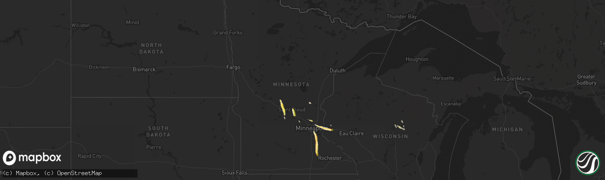
Wind
Hail
18,139
Estimated number of impacted properties by a 1.00" hail or larger2,888
Estimated number of impacted properties by a 1.75" hail or larger0
Estimated number of impacted properties by a 2.50" hail or largerStorm reports in Minnesota
Minnesota
| Date | Description |
|---|---|
| 07/24/20234:45 PM CDT | A local report indicates 1.25 inch wind near 7 W West Concord |
| 07/24/20234:23 PM CDT | Phone report. |
| 07/24/20233:45 PM CDT | Mostly dime hail with some quarter mixed in. Photo relayed via twitter. |
| 07/24/20233:34 PM CDT | Video relayed via social media. |
| 07/24/20233:30 PM CDT | Shredded leaves. |
| 07/24/20233:11 PM CDT | Delayed report - deputy reported golf ball size hail near hampton. Time estimated by radar. |
| 07/24/20233:03 PM CDT | Delayed report - multiple trees on powerlines in farmington. |
| 07/24/20233:02 PM CDT | Photo relayed on social media. |
| 07/24/20233:00 PM CDT | Photo relayed via social media. |
| 07/24/20233:00 PM CDT | Photo via social media. |
| 07/24/20233:00 PM CDT | 12 to 18 inch trees down... Shingles blown off rooftops. Delayed report via trained spotter... Time estimated by radar. |
| 07/24/20233:00 PM CDT | Picture of metal sign bent over. Time estimated from radar. |
| 07/24/20232:55 PM CDT | Delayed report - multiple trees on powerlines in rosemount. |
| 07/24/20232:15 PM CDT | Delayed report - multiple tress and branches down on the southern side of white bear lake. Time estimated from radar. |
All States Impacted by Hail Map on July 24, 2023
Cities Impacted by Hail Map on July 24, 2023
- Leavenworth, KS
- Basehor, KS
- Kansas City, KS
- Kansas City, MO
- Riverside, MO
- Independence, MO
- Lees Summit, MO
- Greenwood, MO
- Lone Jack, MO
- Grain Valley, MO
- Pleasant Hill, MO
- Blue Springs, MO
- Kingsville, MO
- Holden, MO
- Creighton, MO
- Butler, MO
- Urich, MO
- Montrose, MO
- Clinton, MO
- Archie, MO
- Adrian, MO
- Rich Hill, MO
- Appleton City, MO
- Richards, MO
- Walker, MO
- Schell City, MO
- Osceola, MO
- Rockville, MO
- Nevada, MO
- Lowry City, MO
- Deepwater, MO
- El Dorado Springs, MO
- Montrose, PA
- New Milford, PA
- Hallstead, PA
- Susquehanna, PA
- Harford, PA
- South Gibson, PA
- Kingsley, PA
- Jackson, PA
- Thompson, PA
- Windsor, NY
- Montgomery, PA
- Williamsport, PA
- Muncy, PA
- Schroon Lake, NY
- Ellington, MO
- Redford, MO
- McLouth, KS
- Lawrence, KS
- Winona, MO
- King City, MO
- Guilford, MO
- Maysville, MO
- Wyalusing, PA
- Lawton, PA
- Laceyville, PA
- Lenexa, KS
- La Cygne, KS
- Amsterdam, MO
- Van Buren, MO
- Lynchburg, OH
- Mount Orab, OH
- Fayetteville, OH
- New Albany, PA
- Monroeton, PA
- Rome, NY
- Freeman, MO
- Cleveland, MO
- Medina, NY
- Lyndonville, NY
- Eudora, KS
- Wellsville, KS
- Edgerton, KS
- Amity, MO
- Lane, KS
- Osawatomie, KS
- Bucyrus, KS
- Stilwell, KS
- Belton, MO
- Black, MO
- Centerville, MO
- Lesterville, MO
- Garden City, MO
- Strasburg, MO
- Paola, KS
- Louisburg, KS
- Drexel, MO
- Sibley, MO
- Stanberry, MO
- Chittenango, NY
- Canastota, NY
- Union Star, MO
- Rea, MO
- Waynesville, OH
- Springboro, OH
- Dayton, OH
- Miamisburg, OH
- Rushville, MO
- Weston, MO
- Peculiar, MO
- Bonner Springs, KS
- Towanda, PA
- Savannah, MO
- Grandview, MO
- Leawood, KS
- Waldron, MO
- Overland Park, KS
- Shawnee, KS
- Prairie Village, KS
- Raymore, MO
- Dover, KY
- Bunceton, MO
- Pilot Grove, MO
- Hooper, NE
- Muskegon, MI
- Sherrill, IA
- Monticello, WI
- Jesup, IA
- Ravenna, MI
- Irwin, IA
- Copenhagen, NY
- Henderson, NY
- Ogden, IA
- Logan, IA
- Belmont, WI
- Saginaw, MI
- Hazard, NE
- Belleville, WI
- Earlville, IA
- North Bend, NE
- Schuyler, NE
- Templeton, IA
- Sandusky, MI
- Manchester, IA
- Evansville, WI
- Dousman, WI
- Independence, IA
- Dyersville, IA
- Potosi, WI
- Woodbine, IA
- Alma, MI
- Columbus, NE
- Lowville, NY
- Castorland, NY
- Edgerton, WI
- Caro, MI
- Casnovia, MI
- Blair, NE
- Milwaukee, WI
- Beaman, IA
- Saint Louis, MI
- Union, IA
- Cedar Springs, MI
- Deckerville, MI
- Henderson Harbor, NY
- Stanton, MI
- Winthrop, IA
- Wheeler, MI
- Rockville, NE
- Mukwonago, WI
- Blanchardville, WI
- Kent City, MI
- Boone, IA
- Scranton, IA
- Crested Butte, CO
- Reese, MI
- Lindon, CO
- Decker, MI
- Adams, NY
- Silver Creek, NE
- Breckenridge, MI
- Snover, MI
- Darlington, WI
- Fort Atkinson, WI
- Zearing, IA
- New Glarus, WI
- Ames, IA
- Jefferson, IA
- Story City, IA
- Riverdale, MI
- Grand Junction, IA
- Waukesha, WI
- Argyle, WI
- Dannebrog, NE
- Hemlock, MI
- Vestaburg, MI
- Holy Cross, IA
- Sand Lake, MI
- Palmer, NE
- Lexington, NE
- Castle Rock, CO
- Adams Center, NY
- Waterloo, IA
- Parker, CO
- North Prairie, WI
- Rodman, NY
- Vassar, MI
- New Vienna, IA
- Hudson, IA
- New Berlin, WI
- New Providence, IA
- Deford, MI
- Ravenna, NE
- Reinbeck, IA
- Cadyville, NY
- Saranac, NY
- Morrisonville, NY
- Plattsburgh, NY
- West Chazy, NY
- Stillwater, MN
- Bayport, MN
- Hudson, WI
- Roberts, WI
- River Falls, WI
- Lakeland, MN
- Lake Elmo, MN
- Saint Paul, MN
- Inver Grove Heights, MN
- Rosemount, MN
- Hastings, MN
- Farmington, MN
- Hampton, MN
- Freeport, MN
- Albany, MN
- Avon, MN
- Mccordsville, IN
- Indianapolis, IN
- Greenfield, IN
- Aurora, IN
- Paducah, KY
- Ledbetter, KY
- Brookport, IL
- Smithland, KY
- Grand Rivers, KY
- Calvert City, KY
- Eddyville, KY
- Kuttawa, KY
- Princeton, KY
- Gilbertsville, KY
- Baldwin, WI
- Hammond, WI
- Woodville, WI
- Cannon Falls, MN
- Randolph, MN
- Dennison, MN
- Nerstrand, MN
- Kenyon, MN
- Northfield, MN
- Saint Cloud, MN
- Sauk Rapids, MN
- Clear Lake, MN
- Clearwater, MN
- Maple Lake, MN
- Annandale, MN
- Saint Joseph, MN
- Cold Spring, MN
- Richmond, MN
- Watkins, MN
- Dayton, KY
- Newport, KY
- Cincinnati, OH
- Fort Thomas, KY
- Bellevue, KY
- Petersburg, KY
- Burlington, KY
- Rising Sun, IN
- Muncie, IN
- Cerulean, KY
- Cadiz, KY
- Gracey, KY
- Andover, MN
- Minneapolis, MN
- West Concord, MN
- Claremont, MN
- Columbus, OH
- Westerville, OH
- New Albany, OH
- Boonville, IN
- Fountaintown, IN
- Richwood, OH
- Wickliffe, KY
- Saint Regis Falls, NY
- Oriskany, NY
- Westmoreland, NY
- Shelbyville, KY
- Springport, IN
- Middletown, IN
- Daleville, IN
- Selma, IN
- Moriah, NY
- Witherbee, NY
- Moriah Center, NY
- Port Henry, NY
- Mineville, NY
- Cheyenne, WY
- Otisco, IN
- Underwood, IN
- Marysville, IN
- Scottsburg, IN
- Henryville, IN
- Jasper, IN
- Eckerty, IN
- Carthage, NY
- Tamms, IL
- Hartsville, IN
- Hope, IN
- Bethel, OH
- Sardinia, OH
- Syracuse, NY
- Nedrow, NY
- La Fayette, NY
- Jamesville, NY
- Danville, PA
- Watsontown, PA
- Milton, PA
- New Columbia, PA
- Leitchfield, KY
- McDaniels, KY
- Marion, KY
- Grey Eagle, MN
- Burtrum, MN
- Ozark, IL
- Paradox, NY
- Olmstedville, NY
- Coldwater, OH
- Celina, OH
- Westport, IN
- South Haven, MN
- Rushville, IN
- Hartford, KY
- Horse Branch, KY
- Olaton, KY
- Beaver Dam, KY
- Fordsville, KY
- Hillsboro, OH
- Buffalo, MN
- Greensburg, IN
- West Point, KY
- Louisville, KY
- Elizabeth, IN
- North Hudson, NY
- Pueblo, CO
- Chaffee, MO
- Fredonia, KY
- Anoka, MN
- Crown Point, NY
- Ticonderoga, NY
- California, KY
- Butler, KY
- De Mossville, KY
- Moscow, OH
- Calhoun, KY
- Moravia, NY
- Madisonville, KY
- Manitou, KY
- Germantown, KY
- Maysville, KY
- Tennyson, IN
- Lynnville, IN
- Nebo, KY
- Bedford, KY
- Westport, KY
- Salem, KY
- Crofton, KY
- Fishers, IN
- Fortville, IN
- Hawesville, KY
- Allenwood, PA
- Williamsburg, OH
- Blanchester, OH
- Cypress, IL
- Felicity, OH
- Foster, KY
- Dexter, MO
- Covington, KY
- Ft Mitchell, KY
- Rumsey, KY
- West Paducah, KY
- Metropolis, IL
- Seymour, IN
- North Vernon, IN
- Moores Hill, IN
- Ullin, IL
- Brooksville, KY
- Brownstown, IN
- Crothersville, IN
- Glenwood, WV
- Ashton, WV
- Charleston, MO
- Columbus, IN
- Huntingdon, TN
- McKenzie, TN
- Henry, TN
- Lorraine, NY
- Van Etten, NY
- Tiline, KY
- Advance, MO
- Oran, MO
- Sikeston, MO
- Matthews, MO
- Vanduser, MO
- Bell City, MO
- Lowman, NY
- Erin, NY
- Spencer, NY
- La Center, KY
- Bardwell, KY
- Cairo, IL
- Cunningham, KY
- Barlow, KY
- Latonia, KY
- Independence, KY
- Melbourne, KY
- Morning View, KY
- Alexandria, KY
- New Richmond, OH
- Grandview, IN
- Lewisport, KY
- Nabb, IN
- Lexington, IN
- Philpot, KY
- Lamar, IN
- Evanston, IN
- Clinton, AR
- Riverton, WY
- Scott City, MO
- Benton, MO
- Austin, IN
- Huntingburg, IN
- Golconda, IL
- Houston, OH
- Russia, OH
- Grantsburg, IL
- Vienna, IL
- Lander, WY
- White Plains, KY
- Earlington, KY
- Mortons Gap, KY
- Milltown, IN
- Kevil, KY
- Melber, KY
- Cape Girardeau, MO
- Whitewater, MO
- Miller City, IL
- Brooks, KY
- Dale, IN
- Holland, IN
- Sebree, KY
- Sacramento, KY
- Island, KY
- Erlanger, KY
- Florence, KY
- Hampton, KY
- Golden Gate, IL
- Ellery, IL
- Fairfield, IL
- Deputy, IN
- Elizabethtown, KY
- Glendale, KY
- Cecilia, KY
- Magnolia, KY
- Canmer, KY
- Scotland, AR
- Arapahoe, WY
- Marble Hill, MO
- Ferdinand, IN
- Charlestown, IN
- Goshen, KY
- Robards, KY
- Henderson, KY
- Morgantown, KY
- Bloomfield, MO
- Dudley, MO
- Altamont, NY
- Berne, NY
- Gentryville, IN
- Chrisney, IN
- Dongola, IL
- Pulaski, IL
- Thebes, IL
- Jonesboro, IL
- Karnak, IL
- Lewisburg, PA
- Elizabethtown, IN
- La Grange, KY
- Ghent, KY
- Sanders, KY
- Warsaw, KY
- Drakesboro, KY
- Dawson Springs, KY
- Burna, KY
- Caneyville, KY
- Celestine, IN
- Douglas, WY
- Gillette, WY
- Newcastle, WY
- Lance Creek, WY
- Lusk, WY
- Hot Springs, SD
- Harrison, NE
- Oral, SD
- Custer, SD
- Buffalo Gap, SD
- Edgemont, SD
- Crawford, NE
- Aurora, CO
- Denver, CO
- Commerce City, CO
- Watkins, CO
- Bennett, CO
- Hudson, CO
- Brighton, CO
- Pine Ridge, SD
- Oelrichs, SD
- Chadron, NE
- Whitney, NE
- Smithwick, SD
- Crookston, NE
- Batesland, SD
- Kilgore, NE
- Saint Francis, SD
- Tuthill, SD
- Porcupine, SD
- Manderson, SD
- Valentine, NE
- Allen, SD
- Cody, NE
- Oglala, SD
- Martin, SD
- Wounded Knee, SD
- Hay Springs, NE
- Urbana, OH
- English, IN
- Glendo, WY
- Richmond, MI
- Dennison, OH
- Twining, MI
- Conover, OH
- Fletcher, OH
- Augusta, KY
- Grayson, KY
- Medway, OH
- New Carlisle, OH
- Fairborn, OH
- Brackney, PA
- Salem, IN
- Birnamwood, WI
- Wausau, WI
- Aniwa, WI
- Glenwood, IN
- Fort Loramie, OH
- McClure, PA
- Richfield, PA
- McAlisterville, PA
- Beaver Springs, PA
- Ogilvie, MN
- Braham, MN
- Mora, MN
- Ithaca, NY
- Owensboro, KY
- Dundee, KY
- Natural Bridge, NY
- New Washington, IN
- Hodgenville, KY
- Springfield, OH
- Cable, OH
- Springfield, KY
- Vallonia, IN
- Medora, IN
- Lebanon, TN
- Gallatin, TN
- Belleville, WV
- Ravenswood, WV
- Crestwood, KY
- South Charleston, OH
- London, OH
- South Solon, OH
- Fresno, OH
- Coshocton, OH
- Saint Meinrad, IN
- Lancaster, OH
- Pickerington, OH
- Baltimore, OH
- Carroll, OH
- Hockley, TX
- Chemung, NY
- Lockwood, NY
- Elizabeth, WV
- Macfarlan, WV
- Munfordville, KY
- Owingsville, KY
- Hillsboro, KY
- Ewing, KY
- Moorefield, KY
- Carlisle, KY
- Flemingsburg, KY
- Sharpsburg, KY
- Shelbyville, IN
- Chapmansboro, TN
- Ashland City, TN
- Charlotte, TN
- Pendleton, KY
- Bethlehem, IN
- Saint Paris, OH
- Bloomsburg, PA
- Falmouth, KY
- Millersport, OH
- Pataskala, OH
- Reynoldsburg, OH
- Etna, OH
- Gravel Switch, KY
- Eminence, MO
- Rapid City, SD
- Parkersburg, WV
- Bloomfield, IN
- Mount Washington, KY
- Shepherdsville, KY
- Newark Valley, NY
- Goodlettsville, TN
- Mayslick, KY
- Georgetown, OH
- Mount Olivet, KY
- Antigo, WI
- Deerbrook, WI
- White Deer, PA
- Laconia, IN
- Cypress, TX
- Marengo, OH
- Prospect, KY
- Saint Anthony, IN
- Taylorsville, KY
- Bloomfield, KY
- Fairfield, KY
- Coxs Creek, KY
- Jupiter, FL
- Quaker City, OH
- Cambridge, OH
- Old Washington, OH
- Lore City, OH
- Salesville, OH
- Senecaville, OH
- Sellersburg, IN
- Memphis, IN
- Delaware, OH
- Ostrander, OH
- Finchville, KY
- Maceo, KY
- Bardstown, KY
- Mechanicsburg, OH
- Mifflin, PA
- McEwensville, PA
- Turbotville, PA
- Frankfort, KY
- Lawrenceburg, KY
- Waddy, KY
- Lexington, KY
- Midway, KY
- Georgetown, KY
- Versailles, KY
- Lewis Center, OH
- Powell, OH
- Dubois, IN
- Rockport, IN
- Mackville, KY
- Willisburg, KY
- Jersey Shore, PA
- Millersburg, OH
- Simpsonville, KY
- Fisherville, KY
- Galena, OH
- Rockport, WV
- Mineral Wells, WV
- Washington, WV
- Millville, PA
- Cromwell, KY
- Saint Charles, KY
- Quincy, IN
- Cloverdale, IN
- Hickory, KY
- Benton, KY
- Reynolds Station, KY
- Grand Chain, IL
- Tollesboro, KY
- West Liberty, OH
- Dry Ridge, KY
- Williamstown, KY
- Muldraugh, KY
- Alpena, MI
- Plain City, OH
- Dublin, OH
- West Palm Beach, FL
- Lock Haven, PA
- Big Clifty, KY
- Breesport, NY
- Symsonia, KY
- Union Dale, PA
- South Vienna, OH
- Marysville, OH
- Oakland City, IN
- Stamping Ground, KY
- Friendsville, PA
- Sunbury, OH
- Ringle, WI
- Irvington, KY
- Crittenden, KY
- Canal Winchester, OH
- Pleasantville, OH
- French Lick, IN
- Manchester, OH
- Aberdeen, OH
- Ripley, OH
- Endicott, NY
- Blacklick, OH
- Hill City, SD
- Garrison, KY
- Joelton, TN
- Whites Creek, TN
- Fairdale, KY
- Lebanon Junction, KY
- Warsaw, OH
- Walhonding, OH
- Glencoe, KY
- Sparta, KY
- Verona, KY
- Hardinsburg, IN
- Palestine, WV
- Borden, IN
- Pekin, IN
- Waverly, TN
- McEwen, TN
- Hilliard, OH
- West Union, OH
- Greenup, KY
- Merriman, NE
- Marsland, NE
- Wood Lake, NE
- Pleasant City, OH
- Gordon, NE
- Kipling, OH
- Whitman, NE
- Mifflintown, PA
- Port Royal, PA
- Fife Lake, MI
- Torrington, WY
- Scipio, IN
- Newport, PA
- Liverpool, PA
- Millerstown, PA
- Whitesville, KY
- Roseville, OH
- Starrucca, PA
- Hardyville, KY
- New Haven, KY
- Loretto, KY
- Rushville, NE
- Harrodsburg, KY
- Ajo, AZ
- Coolville, OH
- Santa Claus, IN
- Garfield, KY
- Sadieville, KY
- Orangeville, PA
- Halifax, PA
- Clarksville, IN
- Jeffersonville, IN
- Paoli, IN
- Mount Eden, KY
- Pewee Valley, KY
- Belknap, IL
- Taswell, IN
- Thedford, NE
- Brewster, NE
- Johnstown, NE
- Afton, MN
- Ainsworth, NE
- Lancaster, MN


