Hail Map in Kentucky on July 24, 2023
The weather event in Kentucky on July 24, 2023 includes Wind and Hail maps. 22 states and 777 cities were impacted and suffered possible damage. The total estimated number of properties impacted is 4,034.
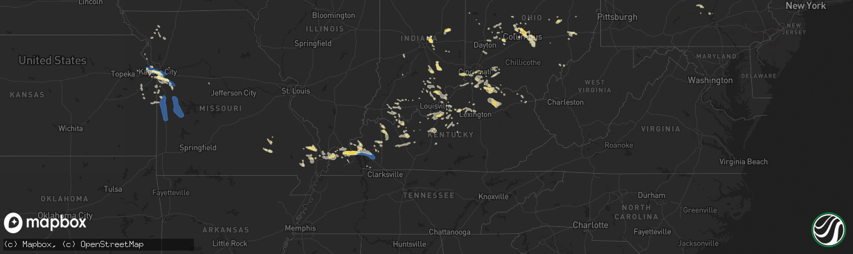
Wind
Hail
4,034
Estimated number of impacted properties by a 1.00" hail or larger441
Estimated number of impacted properties by a 1.75" hail or larger0
Estimated number of impacted properties by a 2.50" hail or largerStorm reports in Kentucky
Kentucky
| Date | Description |
|---|---|
| 07/24/20236:45 PM CDT | Trees down. About 600 customers without power. |
| 07/24/20236:42 PM CDT | Trees down. |
| 07/24/20236:14 PM CDT | A few trees down along mary ingles highway. Time estimated from radar. |
| 07/24/20235:45 PM CDT | Delayed report. Trees down along brownsville road. Time estimated by radar. |
| 07/24/20235:37 PM CDT | Delayed report. Trees down along sanders road. Time estimated by radar. |
| 07/24/20235:29 PM CDT | Tree down. |
| 07/24/20235:18 PM CDT | Delayed report. Several trees down throughout the county. Time estimated by radar. |
| 07/24/20234:42 PM CDT | Tree downed along winding way. Time estimated by radar. |
| 07/24/20234:39 PM CDT | Two trees down. |
| 07/24/20234:26 PM CDT | Tree down. |
| 07/24/20234:14 PM CDT | Trees down over hwy 903 in caldwell county. |
| 07/24/20234:05 PM CDT | Wind gust recorded by ky mesonet station near princeton ky. |
| 07/24/20233:55 PM CDT | Multiple reports of trees down in princeton. |
| 07/24/20233:40 PM CDT | Tree down 3 mi ne of grand rivers over highway 62. |
| 07/24/20233:27 PM CDT | Quarter to golfball sized hail reported by public in smithland kentucky. |
| 07/24/20233:20 PM CDT | Trees down in fredonia. |
| 07/24/20233:18 PM CDT | Trained spotter reported 60 mph wind gust. |
| 07/24/20233:18 PM CDT | Trained spotter report of 1.5 inch hail. |
| 07/24/20233:10 PM CDT | Power lines down and trees down in symsonia area. |
| 07/24/20233:05 PM CDT | Report by off-duty nws employee. Large tree limbs down in neighborhood near noble park area. Measured 1.88 inches of rain within about 1 hour. |
| 07/24/20232:35 PM CDT | One tree down and several limbs near mccracken-ballard border. Approximately 5 miles west-southwest of nws office. |
| 07/23/20237:42 PM CDT | A tree was blown down a few miles north of preston on kendall springs road. |
| 07/23/20237:30 PM CDT | Downed tree blocking rooster run road. |
All States Impacted by Hail Map on July 24, 2023
Cities Impacted by Hail Map on July 24, 2023
- Leavenworth, KS
- Basehor, KS
- Kansas City, KS
- Kansas City, MO
- Riverside, MO
- Independence, MO
- Lees Summit, MO
- Greenwood, MO
- Lone Jack, MO
- Grain Valley, MO
- Pleasant Hill, MO
- Blue Springs, MO
- Kingsville, MO
- Holden, MO
- Creighton, MO
- Butler, MO
- Urich, MO
- Montrose, MO
- Clinton, MO
- Archie, MO
- Adrian, MO
- Rich Hill, MO
- Appleton City, MO
- Richards, MO
- Walker, MO
- Schell City, MO
- Osceola, MO
- Rockville, MO
- Nevada, MO
- Lowry City, MO
- Deepwater, MO
- El Dorado Springs, MO
- Montrose, PA
- New Milford, PA
- Hallstead, PA
- Susquehanna, PA
- Harford, PA
- South Gibson, PA
- Kingsley, PA
- Jackson, PA
- Thompson, PA
- Windsor, NY
- Montgomery, PA
- Williamsport, PA
- Muncy, PA
- Schroon Lake, NY
- Ellington, MO
- Redford, MO
- McLouth, KS
- Lawrence, KS
- Winona, MO
- King City, MO
- Guilford, MO
- Maysville, MO
- Wyalusing, PA
- Lawton, PA
- Laceyville, PA
- Lenexa, KS
- La Cygne, KS
- Amsterdam, MO
- Van Buren, MO
- Lynchburg, OH
- Mount Orab, OH
- Fayetteville, OH
- New Albany, PA
- Monroeton, PA
- Rome, NY
- Freeman, MO
- Cleveland, MO
- Medina, NY
- Lyndonville, NY
- Eudora, KS
- Wellsville, KS
- Edgerton, KS
- Amity, MO
- Lane, KS
- Osawatomie, KS
- Bucyrus, KS
- Stilwell, KS
- Belton, MO
- Black, MO
- Centerville, MO
- Lesterville, MO
- Garden City, MO
- Strasburg, MO
- Paola, KS
- Louisburg, KS
- Drexel, MO
- Sibley, MO
- Stanberry, MO
- Chittenango, NY
- Canastota, NY
- Union Star, MO
- Rea, MO
- Waynesville, OH
- Springboro, OH
- Dayton, OH
- Miamisburg, OH
- Rushville, MO
- Weston, MO
- Peculiar, MO
- Bonner Springs, KS
- Towanda, PA
- Savannah, MO
- Grandview, MO
- Leawood, KS
- Waldron, MO
- Overland Park, KS
- Shawnee, KS
- Prairie Village, KS
- Raymore, MO
- Dover, KY
- Bunceton, MO
- Pilot Grove, MO
- Hooper, NE
- Muskegon, MI
- Sherrill, IA
- Monticello, WI
- Jesup, IA
- Ravenna, MI
- Irwin, IA
- Copenhagen, NY
- Henderson, NY
- Ogden, IA
- Logan, IA
- Belmont, WI
- Saginaw, MI
- Hazard, NE
- Belleville, WI
- Earlville, IA
- North Bend, NE
- Schuyler, NE
- Templeton, IA
- Sandusky, MI
- Manchester, IA
- Evansville, WI
- Dousman, WI
- Independence, IA
- Dyersville, IA
- Potosi, WI
- Woodbine, IA
- Alma, MI
- Columbus, NE
- Lowville, NY
- Castorland, NY
- Edgerton, WI
- Caro, MI
- Casnovia, MI
- Blair, NE
- Milwaukee, WI
- Beaman, IA
- Saint Louis, MI
- Union, IA
- Cedar Springs, MI
- Deckerville, MI
- Henderson Harbor, NY
- Stanton, MI
- Winthrop, IA
- Wheeler, MI
- Rockville, NE
- Mukwonago, WI
- Blanchardville, WI
- Kent City, MI
- Boone, IA
- Scranton, IA
- Crested Butte, CO
- Reese, MI
- Lindon, CO
- Decker, MI
- Adams, NY
- Silver Creek, NE
- Breckenridge, MI
- Snover, MI
- Darlington, WI
- Fort Atkinson, WI
- Zearing, IA
- New Glarus, WI
- Ames, IA
- Jefferson, IA
- Story City, IA
- Riverdale, MI
- Grand Junction, IA
- Waukesha, WI
- Argyle, WI
- Dannebrog, NE
- Hemlock, MI
- Vestaburg, MI
- Holy Cross, IA
- Sand Lake, MI
- Palmer, NE
- Lexington, NE
- Castle Rock, CO
- Adams Center, NY
- Waterloo, IA
- Parker, CO
- North Prairie, WI
- Rodman, NY
- Vassar, MI
- New Vienna, IA
- Hudson, IA
- New Berlin, WI
- New Providence, IA
- Deford, MI
- Ravenna, NE
- Reinbeck, IA
- Cadyville, NY
- Saranac, NY
- Morrisonville, NY
- Plattsburgh, NY
- West Chazy, NY
- Stillwater, MN
- Bayport, MN
- Hudson, WI
- Roberts, WI
- River Falls, WI
- Lakeland, MN
- Lake Elmo, MN
- Saint Paul, MN
- Inver Grove Heights, MN
- Rosemount, MN
- Hastings, MN
- Farmington, MN
- Hampton, MN
- Freeport, MN
- Albany, MN
- Avon, MN
- Mccordsville, IN
- Indianapolis, IN
- Greenfield, IN
- Aurora, IN
- Paducah, KY
- Ledbetter, KY
- Brookport, IL
- Smithland, KY
- Grand Rivers, KY
- Calvert City, KY
- Eddyville, KY
- Kuttawa, KY
- Princeton, KY
- Gilbertsville, KY
- Baldwin, WI
- Hammond, WI
- Woodville, WI
- Cannon Falls, MN
- Randolph, MN
- Dennison, MN
- Nerstrand, MN
- Kenyon, MN
- Northfield, MN
- Saint Cloud, MN
- Sauk Rapids, MN
- Clear Lake, MN
- Clearwater, MN
- Maple Lake, MN
- Annandale, MN
- Saint Joseph, MN
- Cold Spring, MN
- Richmond, MN
- Watkins, MN
- Dayton, KY
- Newport, KY
- Cincinnati, OH
- Fort Thomas, KY
- Bellevue, KY
- Petersburg, KY
- Burlington, KY
- Rising Sun, IN
- Muncie, IN
- Cerulean, KY
- Cadiz, KY
- Gracey, KY
- Andover, MN
- Minneapolis, MN
- West Concord, MN
- Claremont, MN
- Columbus, OH
- Westerville, OH
- New Albany, OH
- Boonville, IN
- Fountaintown, IN
- Richwood, OH
- Wickliffe, KY
- Saint Regis Falls, NY
- Oriskany, NY
- Westmoreland, NY
- Shelbyville, KY
- Springport, IN
- Middletown, IN
- Daleville, IN
- Selma, IN
- Moriah, NY
- Witherbee, NY
- Moriah Center, NY
- Port Henry, NY
- Mineville, NY
- Cheyenne, WY
- Otisco, IN
- Underwood, IN
- Marysville, IN
- Scottsburg, IN
- Henryville, IN
- Jasper, IN
- Eckerty, IN
- Carthage, NY
- Tamms, IL
- Hartsville, IN
- Hope, IN
- Bethel, OH
- Sardinia, OH
- Syracuse, NY
- Nedrow, NY
- La Fayette, NY
- Jamesville, NY
- Danville, PA
- Watsontown, PA
- Milton, PA
- New Columbia, PA
- Leitchfield, KY
- McDaniels, KY
- Marion, KY
- Grey Eagle, MN
- Burtrum, MN
- Ozark, IL
- Paradox, NY
- Olmstedville, NY
- Coldwater, OH
- Celina, OH
- Westport, IN
- South Haven, MN
- Rushville, IN
- Hartford, KY
- Horse Branch, KY
- Olaton, KY
- Beaver Dam, KY
- Fordsville, KY
- Hillsboro, OH
- Buffalo, MN
- Greensburg, IN
- West Point, KY
- Louisville, KY
- Elizabeth, IN
- North Hudson, NY
- Pueblo, CO
- Chaffee, MO
- Fredonia, KY
- Anoka, MN
- Crown Point, NY
- Ticonderoga, NY
- California, KY
- Butler, KY
- De Mossville, KY
- Moscow, OH
- Calhoun, KY
- Moravia, NY
- Madisonville, KY
- Manitou, KY
- Germantown, KY
- Maysville, KY
- Tennyson, IN
- Lynnville, IN
- Nebo, KY
- Bedford, KY
- Westport, KY
- Salem, KY
- Crofton, KY
- Fishers, IN
- Fortville, IN
- Hawesville, KY
- Allenwood, PA
- Williamsburg, OH
- Blanchester, OH
- Cypress, IL
- Felicity, OH
- Foster, KY
- Dexter, MO
- Covington, KY
- Ft Mitchell, KY
- Rumsey, KY
- West Paducah, KY
- Metropolis, IL
- Seymour, IN
- North Vernon, IN
- Moores Hill, IN
- Ullin, IL
- Brooksville, KY
- Brownstown, IN
- Crothersville, IN
- Glenwood, WV
- Ashton, WV
- Charleston, MO
- Columbus, IN
- Huntingdon, TN
- McKenzie, TN
- Henry, TN
- Lorraine, NY
- Van Etten, NY
- Tiline, KY
- Advance, MO
- Oran, MO
- Sikeston, MO
- Matthews, MO
- Vanduser, MO
- Bell City, MO
- Lowman, NY
- Erin, NY
- Spencer, NY
- La Center, KY
- Bardwell, KY
- Cairo, IL
- Cunningham, KY
- Barlow, KY
- Latonia, KY
- Independence, KY
- Melbourne, KY
- Morning View, KY
- Alexandria, KY
- New Richmond, OH
- Grandview, IN
- Lewisport, KY
- Nabb, IN
- Lexington, IN
- Philpot, KY
- Lamar, IN
- Evanston, IN
- Clinton, AR
- Riverton, WY
- Scott City, MO
- Benton, MO
- Austin, IN
- Huntingburg, IN
- Golconda, IL
- Houston, OH
- Russia, OH
- Grantsburg, IL
- Vienna, IL
- Lander, WY
- White Plains, KY
- Earlington, KY
- Mortons Gap, KY
- Milltown, IN
- Kevil, KY
- Melber, KY
- Cape Girardeau, MO
- Whitewater, MO
- Miller City, IL
- Brooks, KY
- Dale, IN
- Holland, IN
- Sebree, KY
- Sacramento, KY
- Island, KY
- Erlanger, KY
- Florence, KY
- Hampton, KY
- Golden Gate, IL
- Ellery, IL
- Fairfield, IL
- Deputy, IN
- Elizabethtown, KY
- Glendale, KY
- Cecilia, KY
- Magnolia, KY
- Canmer, KY
- Scotland, AR
- Arapahoe, WY
- Marble Hill, MO
- Ferdinand, IN
- Charlestown, IN
- Goshen, KY
- Robards, KY
- Henderson, KY
- Morgantown, KY
- Bloomfield, MO
- Dudley, MO
- Altamont, NY
- Berne, NY
- Gentryville, IN
- Chrisney, IN
- Dongola, IL
- Pulaski, IL
- Thebes, IL
- Jonesboro, IL
- Karnak, IL
- Lewisburg, PA
- Elizabethtown, IN
- La Grange, KY
- Ghent, KY
- Sanders, KY
- Warsaw, KY
- Drakesboro, KY
- Dawson Springs, KY
- Burna, KY
- Caneyville, KY
- Celestine, IN
- Douglas, WY
- Gillette, WY
- Newcastle, WY
- Lance Creek, WY
- Lusk, WY
- Hot Springs, SD
- Harrison, NE
- Oral, SD
- Custer, SD
- Buffalo Gap, SD
- Edgemont, SD
- Crawford, NE
- Aurora, CO
- Denver, CO
- Commerce City, CO
- Watkins, CO
- Bennett, CO
- Hudson, CO
- Brighton, CO
- Pine Ridge, SD
- Oelrichs, SD
- Chadron, NE
- Whitney, NE
- Smithwick, SD
- Crookston, NE
- Batesland, SD
- Kilgore, NE
- Saint Francis, SD
- Tuthill, SD
- Porcupine, SD
- Manderson, SD
- Valentine, NE
- Allen, SD
- Cody, NE
- Oglala, SD
- Martin, SD
- Wounded Knee, SD
- Hay Springs, NE
- Urbana, OH
- English, IN
- Glendo, WY
- Richmond, MI
- Dennison, OH
- Twining, MI
- Conover, OH
- Fletcher, OH
- Augusta, KY
- Grayson, KY
- Medway, OH
- New Carlisle, OH
- Fairborn, OH
- Brackney, PA
- Salem, IN
- Birnamwood, WI
- Wausau, WI
- Aniwa, WI
- Glenwood, IN
- Fort Loramie, OH
- McClure, PA
- Richfield, PA
- McAlisterville, PA
- Beaver Springs, PA
- Ogilvie, MN
- Braham, MN
- Mora, MN
- Ithaca, NY
- Owensboro, KY
- Dundee, KY
- Natural Bridge, NY
- New Washington, IN
- Hodgenville, KY
- Springfield, OH
- Cable, OH
- Springfield, KY
- Vallonia, IN
- Medora, IN
- Lebanon, TN
- Gallatin, TN
- Belleville, WV
- Ravenswood, WV
- Crestwood, KY
- South Charleston, OH
- London, OH
- South Solon, OH
- Fresno, OH
- Coshocton, OH
- Saint Meinrad, IN
- Lancaster, OH
- Pickerington, OH
- Baltimore, OH
- Carroll, OH
- Hockley, TX
- Chemung, NY
- Lockwood, NY
- Elizabeth, WV
- Macfarlan, WV
- Munfordville, KY
- Owingsville, KY
- Hillsboro, KY
- Ewing, KY
- Moorefield, KY
- Carlisle, KY
- Flemingsburg, KY
- Sharpsburg, KY
- Shelbyville, IN
- Chapmansboro, TN
- Ashland City, TN
- Charlotte, TN
- Pendleton, KY
- Bethlehem, IN
- Saint Paris, OH
- Bloomsburg, PA
- Falmouth, KY
- Millersport, OH
- Pataskala, OH
- Reynoldsburg, OH
- Etna, OH
- Gravel Switch, KY
- Eminence, MO
- Rapid City, SD
- Parkersburg, WV
- Bloomfield, IN
- Mount Washington, KY
- Shepherdsville, KY
- Newark Valley, NY
- Goodlettsville, TN
- Mayslick, KY
- Georgetown, OH
- Mount Olivet, KY
- Antigo, WI
- Deerbrook, WI
- White Deer, PA
- Laconia, IN
- Cypress, TX
- Marengo, OH
- Prospect, KY
- Saint Anthony, IN
- Taylorsville, KY
- Bloomfield, KY
- Fairfield, KY
- Coxs Creek, KY
- Jupiter, FL
- Quaker City, OH
- Cambridge, OH
- Old Washington, OH
- Lore City, OH
- Salesville, OH
- Senecaville, OH
- Sellersburg, IN
- Memphis, IN
- Delaware, OH
- Ostrander, OH
- Finchville, KY
- Maceo, KY
- Bardstown, KY
- Mechanicsburg, OH
- Mifflin, PA
- McEwensville, PA
- Turbotville, PA
- Frankfort, KY
- Lawrenceburg, KY
- Waddy, KY
- Lexington, KY
- Midway, KY
- Georgetown, KY
- Versailles, KY
- Lewis Center, OH
- Powell, OH
- Dubois, IN
- Rockport, IN
- Mackville, KY
- Willisburg, KY
- Jersey Shore, PA
- Millersburg, OH
- Simpsonville, KY
- Fisherville, KY
- Galena, OH
- Rockport, WV
- Mineral Wells, WV
- Washington, WV
- Millville, PA
- Cromwell, KY
- Saint Charles, KY
- Quincy, IN
- Cloverdale, IN
- Hickory, KY
- Benton, KY
- Reynolds Station, KY
- Grand Chain, IL
- Tollesboro, KY
- West Liberty, OH
- Dry Ridge, KY
- Williamstown, KY
- Muldraugh, KY
- Alpena, MI
- Plain City, OH
- Dublin, OH
- West Palm Beach, FL
- Lock Haven, PA
- Big Clifty, KY
- Breesport, NY
- Symsonia, KY
- Union Dale, PA
- South Vienna, OH
- Marysville, OH
- Oakland City, IN
- Stamping Ground, KY
- Friendsville, PA
- Sunbury, OH
- Ringle, WI
- Irvington, KY
- Crittenden, KY
- Canal Winchester, OH
- Pleasantville, OH
- French Lick, IN
- Manchester, OH
- Aberdeen, OH
- Ripley, OH
- Endicott, NY
- Blacklick, OH
- Hill City, SD
- Garrison, KY
- Joelton, TN
- Whites Creek, TN
- Fairdale, KY
- Lebanon Junction, KY
- Warsaw, OH
- Walhonding, OH
- Glencoe, KY
- Sparta, KY
- Verona, KY
- Hardinsburg, IN
- Palestine, WV
- Borden, IN
- Pekin, IN
- Waverly, TN
- McEwen, TN
- Hilliard, OH
- West Union, OH
- Greenup, KY
- Merriman, NE
- Marsland, NE
- Wood Lake, NE
- Pleasant City, OH
- Gordon, NE
- Kipling, OH
- Whitman, NE
- Mifflintown, PA
- Port Royal, PA
- Fife Lake, MI
- Torrington, WY
- Scipio, IN
- Newport, PA
- Liverpool, PA
- Millerstown, PA
- Whitesville, KY
- Roseville, OH
- Starrucca, PA
- Hardyville, KY
- New Haven, KY
- Loretto, KY
- Rushville, NE
- Harrodsburg, KY
- Ajo, AZ
- Coolville, OH
- Santa Claus, IN
- Garfield, KY
- Sadieville, KY
- Orangeville, PA
- Halifax, PA
- Clarksville, IN
- Jeffersonville, IN
- Paoli, IN
- Mount Eden, KY
- Pewee Valley, KY
- Belknap, IL
- Taswell, IN
- Thedford, NE
- Brewster, NE
- Johnstown, NE
- Afton, MN
- Ainsworth, NE
- Lancaster, MN


