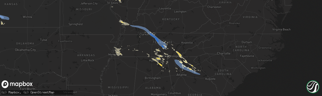
Hail Map in Tennessee on July 20, 2023
The weather event in Tennessee on July 20, 2023 includes Hail, Wind, and Tornado maps. 22 states and 1,246 cities were impacted and suffered possible damage. The total estimated number of properties impacted is 0.
Hail
Wind
Tornado
0
Estimated number of impacted properties by a 1.00" hail or larger0
Estimated number of impacted properties by a 1.75" hail or larger0
Estimated number of impacted properties by a 2.50" hail or largerStorm reports in Tennessee
Tennessee
| Date | Description |
|---|---|
| 07/20/20233:05 PM CDT | County dispatch reported numerous trees and powerlines down across the county. Mentioned that the worst area seemed to be around signal mountain. Time estimated by rada |
| 07/20/20232:46 PM CDT | Dispatch reported numerous trees and powerlines down across the county. Time estimated by radar. |
| 07/20/20232:45 PM CDT | Corrects time of previous tstm wnd dmg report from 3 ne tullahoma. Trees down with multiple power outages in the short springs/ovoca area. Time is radar estimated. |
| 07/20/20232:43 PM CDT | Twitter photos received of the roof blown off of life style staffing office as well as a large tree blown down in the parking lot. Time is radar estimated. |
| 07/20/20232:42 PM CDT | Photo received via twitter of large tree down off of anthony lane in shelbyville. Time is radar estimated. |
| 07/20/20232:42 PM CDT | Photo received via twitter of quarter size hail at titan transfer off of stanley blvd. Time estimated on radar. |
| 07/20/20232:42 PM CDT | Photo received via twitter of large tree down off of anthony lane in shelbyvilger reports numerous trees down between wren... Oh and ohio city... Oh. |
| 07/20/20232:38 PM CDT | Multiple photos received of barn destroyed... Large tree uprooted... And smaller trees blown down along mcclain road. Time estimated on radar. |
| 07/20/20232:35 PM CDT | Roads flooded in the flat creek area. |
| 07/20/20232:30 PM CDT | Tree down on vehicle on cedar lane. |
| 07/20/20232:29 PM CDT | Trees down with multiple power outages in the short springs/ovoca area. Time is radar estimated. |
| 07/20/20232:25 PM CDT | Photo received via facebook of a shed blown down off of shelbyville rd. Near trousdale church. Time is radar estimated. |
| 07/20/20232:21 PM CDT | Photo received via facebook of roof torn off of meeks tire co. Time is radar estimated. |
| 07/20/20232:17 PM CDT | Photo received via twitter of a large pine tree down in centertown off of hwy 70-south near the warren/cannon county line. Time is radar estimated. |
| 07/20/20232:15 PM CDT | Dispatch reported tree down near patty road. |
| 07/20/20232:05 PM CDT | Tree down and outbuilding damaged on old kentucky rd near central view market. |
| 07/20/20232:00 PM CDT | 20 trees snapped on buckner rd at mt view ln. |
| 07/20/20231:58 PM CDT | Twitter video showed large tree blown down on midway road near terrell road. Other scattered trees and power lines reported down across the county. |
| 07/20/20231:57 PM CDT | 10 inch diameter pine tree snapped on hwy 70 near the cannon and warren county line. |
| 07/20/20231:55 PM CDT | Corrects previous tstm wnd dmg report from 3 ne tullahoma. Trees down and power poles snapped with multiple power outages in the short springs/ovoca area. Time is radar |
| 07/20/20231:53 PM CDT | Trees down on red hill rd. |
| 07/20/20231:52 PM CDT | Carport destroyed and mini barn flipped over on hwy 53 at simpson road. |
| 07/20/20231:48 PM CDT | Photo received via twitter of tree uprooted on sunny slope rd. Near woodbury. Time is radar estimated. |
| 07/20/20231:42 PM CDT | Photo received via twitter of tree down on bradyville road. Time is radar estimated. |
| 07/20/20231:33 PM CDT | Large tree down blocking cranor road. |
| 07/20/20231:33 PM CDT | Large tree down blocking cranor road. |
| 07/20/20231:30 PM CDT | Trees down and dugout damaged in lascassas. |
| 07/20/20231:27 PM CDT | Dispatch reported trees down throughout county. Time estimated from radar. |
| 07/20/20231:25 PM CDT | Tspotter photo of large tree down blocking hwy 100 at old harding pike. |
| 07/20/20231:20 PM CDT | Photo received via facebook of large tree that went through roof of home off of lakeshore drive in old hickory. Time is radar estimated. |
| 07/20/20231:12 PM CDT | Nws employee estimated 70-80 mph winds in mount juliet. |
| 07/20/20231:12 PM CDT | Photo received via twitter of a large tree down at a home off of vanderbilt rd. Time is radar estimated. |
| 07/20/20231:10 PM CDT | Trees and power lines down across mount juliet. |
| 07/20/20231:10 PM CDT | Photo received via facebook of a large tree snapped in half at a home off of n greenhill rd. Near needmore rd. Time is radar estimated. |
| 07/20/20231:10 PM CDT | Trees and power lines down across mount juliet. Homes across cherokee county. |
| 07/20/20231:01 PM CDT | Several trees down along vanderbilt rd. |
| 07/20/20231:01 PM CDT | Photo received via facebook of a large tree down on powerlines blocking a portion of shirley drive. Time is radar estimated. |
| 07/20/20231:00 PM CDT | Social media photos of numerous trees down around gallatin with some blocking roads. |
| 07/20/202312:55 PM CDT | Numerous trees and power lines down across southwestern sumner county. One tree fell onto and crushed a house on raintree dr. |
| 07/20/202312:54 PM CDT | Numerous trees and power lines down in the greenbrier and ridgetop areas. |
| 07/20/202312:51 PM CDT | Power lines down and large power poles leaning near rivergate mall. |
| 07/20/202312:50 PM CDT | Dispatch reported trees down throughout county. Time estimated from radar. |
| 07/20/202312:48 PM CDT | Trees and power lines coming down all over the place. |
| 07/20/202312:45 PM CDT | Dispatch reported trees down throughout the county. Time estimated from radar. |
| 07/20/202312:45 PM CDT | Corrects time of previous tstm wnd dmg report from 1 ne ridgetop. Photos received of large tree down near home as well as shutters blown off into the bushes on lake rd. |
| 07/20/202312:40 PM CDT | Dispatch call center reported trees down throughout the county. Time estimated from radar. |
| 07/20/202312:34 PM CDT | Trees and power lines down throughout robertson county with many across roads. |
| 07/20/202312:34 PM CDT | Multiple homes with trees down on the roof and power lines down all across the 2500 block of kelly willis road. Time is radar estimated. |
| 07/20/202312:32 PM CDT | Two trees down on kinneys rd.... One at airport rd. Junction and the other at justice rd. Junction. |
| 07/20/202312:21 PM CDT | Photo and report received via facebook of a large tree uprooted with notable tree damage along charles bell road and hartley drive. Time is radar estimated. |
| 07/20/202312:20 PM CDT | Numerous trees and power lines down across the county... Especially northeastern areas. |
| 07/20/202312:20 PM CDT | Photos received of large tree down near home as well as shutters blown off into the bushes on lake rd. In greenbrier. Time is radar estimated. |
All States Impacted by Hail Map on July 20, 2023
Cities Impacted by Hail Map on July 20, 2023
- Bonne Terre, MO
- Farmington, MO
- Roodhouse, IL
- White Hall, IL
- Greenfield, IL
- Hettick, IL
- New Berlin, IL
- Carlinville, IL
- Shipman, IL
- Gillespie, IL
- Paducah, KY
- Brookport, IL
- Ledbetter, KY
- Gilbertsville, KY
- Smithland, KY
- Calvert City, KY
- Grand Rivers, KY
- Kuttawa, KY
- Eddyville, KY
- Sterling, CO
- Iliff, CO
- Princeton, KY
- Cadiz, KY
- Cerulean, KY
- Gracey, KY
- Crofton, KY
- Hopkinsville, KY
- Fleming, CO
- Pembroke, KY
- Trenton, KY
- Elkton, KY
- Guthrie, KY
- Clarksville, TN
- Allensville, KY
- Adams, TN
- Olmstead, KY
- Springfield, TN
- Cedar Hill, TN
- Adairville, KY
- Greenbrier, TN
- White House, TN
- Goodlettsville, TN
- Hendersonville, TN
- Cottontown, TN
- Madison, TN
- Gallatin, TN
- Bannister, MI
- Brant, MI
- Elsie, MI
- Ashley, MI
- Oakley, MI
- Henderson, MI
- Chesaning, MI
- Old Hickory, TN
- Mount Juliet, TN
- Lebanon, TN
- Hermitage, TN
- Stewart, TN
- Metropolis, IL
- Jacksonville, IL
- Murrayville, IL
- Carlyle, IL
- Winchester, IL
- Sheridan, MI
- French Village, MO
- Sedgewickville, MO
- Friedheim, MO
- Perryville, MO
- Greenville, MI
- Edwardsville, IL
- Padroni, CO
- Waterloo, IL
- Grand Chain, IL
- Sainte Genevieve, MO
- Saint Mary, MO
- Stanton, MI
- Hersey, MI
- Reed City, MI
- Evart, MI
- Oak Ridge, MO
- Daisy, MO
- Patton, MO
- Ullin, IL
- Olmsted, IL
- Kevil, KY
- Pulaski, IL
- Alexander, IL
- Jackson, MO
- Cape Girardeau, MO
- Jonesboro, IL
- McClure, IL
- Lake City, PA
- East Springfield, PA
- Girard, PA
- Osage Beach, MO
- Kaiser, MO
- Linn Creek, MO
- Thebes, IL
- Tamms, IL
- Kirk, CO
- Lakeview, MI
- Pocahontas, IL
- Crossville, TN
- Oak Grove, KY
- Pentwater, MI
- Ludington, MI
- Orlinda, TN
- Benld, IL
- Chesterfield, IL
- Sidney, MI
- Fredericktown, MO
- Russellville, KY
- Howard City, MI
- Morley, MI
- Fort Campbell, KY
- Potosi, MO
- Alhambra, IL
- Livingston, IL
- Staunton, IL
- New Douglas, IL
- Baxter, TN
- Gowen, MI
- De Soto, MO
- Valles Mines, MO
- Aviston, IL
- Festus, MO
- Bloomsdale, MO
- Rockford, MI
- Merino, CO
- Lake, MI
- Breese, IL
- Highland, IL
- Palmyra, IL
- Sawyerville, IL
- Mount Olive, IL
- Golden Eagle, IL
- Bunker Hill, IL
- Wilsonville, IL
- Fenwick, MI
- Vestaburg, MI
- Six Lakes, MI
- Coral, MI
- Newaygo, MI
- Trufant, MI
- White Cloud, MI
- Crystal, MI
- Moro, IL
- Mounds, IL
- Olive Branch, IL
- Villa Ridge, IL
- Brumley, MO
- La Center, KY
- Barlow, KY
- Dongola, IL
- West Paducah, KY
- Karnak, IL
- Cypress, IL
- Stoneham, CO
- Park Hills, MO
- Murfreesboro, TN
- New Lothrop, MI
- Owosso, MI
- Montrose, MI
- Corunna, MI
- Dewitt, MI
- Bath, MI
- Laingsburg, MI
- Flint, MI
- Clio, MI
- Flushing, MI
- Lennon, MI
- Swartz Creek, MI
- Mount Morris, MI
- Fairview, PA
- Erie, PA
- McKean, PA
- Harborcreek, PA
- North East, PA
- Ripley, NY
- Burton, MI
- Davison, MI
- Genesee, MI
- Schoolcraft, MI
- Vicksburg, MI
- Lapeer, MI
- Lascassas, TN
- Auburntown, TN
- Watertown, TN
- Milton, TN
- Liberty, TN
- Alexandria, TN
- Dowelltown, TN
- Smithville, TN
- Woodbury, TN
- Readyville, TN
- Mcminnville, TN
- Bradyville, TN
- Morrison, TN
- Saint Johns, MI
- Ovid, MI
- Durand, MI
- Holt, MI
- Leslie, MI
- Mason, MI
- Dansville, MI
- Williamston, MI
- Webberville, MI
- Fowlerville, MI
- Stockbridge, MI
- Brighton, MI
- Gregory, MI
- Howell, MI
- Pinckney, MI
- Capac, MI
- Imlay City, MI
- Allenton, MI
- Almont, MI
- Dryden, MI
- Otisville, MI
- Grand Blanc, MI
- Goodrich, MI
- Atlas, MI
- Oxford, MI
- Metamora, MI
- Hadley, MI
- Ortonville, MI
- Columbiaville, MI
- Detroit, MI
- Highland Park, MI
- Ferndale, MI
- Warren, MI
- Hamtramck, MI
- Hazel Park, MI
- South Bend, IN
- Mishawaka, IN
- Osceola, IN
- Eastpointe, MI
- Saint Clair Shores, MI
- Roseville, MI
- Harper Woods, MI
- Avoca, MI
- Emmett, MI
- Jeddo, MI
- North Street, MI
- Clinton Township, MI
- Harrison Township, MI
- Elkhart, IN
- Goshen, IN
- Clarkston, MI
- Rock Island, TN
- Fort Gratiot, MI
- Center Line, MI
- Bennett, CO
- Columbus, MI
- Saint Clair, MI
- Casco, MI
- East China, MI
- Marysville, MI
- Divide, CO
- Woodland Park, CO
- Green Mountain Falls, CO
- Cascade, CO
- Colorado Springs, CO
- Attica, MI
- Romeo, MI
- Washington, MI
- Leonard, MI
- Rochester, MI
- Oakland, MI
- Ray, MI
- Macomb, MI
- Utica, MI
- Armada, MI
- New Baltimore, MI
- New Haven, MI
- Harsens Island, MI
- Fair Haven, MI
- Algonac, MI
- Marine City, MI
- Richmond, MI
- Smiths Creek, MI
- Goodells, MI
- Memphis, MI
- Yale, MI
- Port Huron, MI
- Manitou Springs, CO
- Middlebury, IN
- Millersburg, IN
- Elizabeth, CO
- Albion, PA
- Cranesville, PA
- Edinboro, PA
- Kiowa, CO
- West Springfield, PA
- Ypsilanti, MI
- Ann Arbor, MI
- Canton, MI
- Belleville, MI
- Wayne, MI
- Dexter, MI
- Chelsea, MI
- Peyton, CO
- Elbert, CO
- Strasburg, CO
- Byers, CO
- Fort Morgan, CO
- Calhan, CO
- Ramah, CO
- Wallace, KS
- Sharon Springs, KS
- Leoti, KS
- Winona, KS
- Marienthal, KS
- Scott City, KS
- Simla, CO
- Boncarbo, CO
- Trinidad, CO
- Waterford, PA
- Holcomb, KS
- Garden City, KS
- Deerfield, KS
- Yoder, CO
- Union City, PA
- Walsenburg, CO
- Lakin, KS
- Wakeman, OH
- Oberlin, OH
- Chardon, OH
- Brookpark, OH
- Montville, OH
- Norwalk, OH
- Jefferson, OH
- Wellington, OH
- Beachwood, OH
- Grafton, OH
- New London, OH
- Kingsville, OH
- Independence, OH
- Berea, OH
- Springboro, PA
- Rock Creek, OH
- Pierpont, OH
- North Fairfield, OH
- Lagrange, OH
- Conneaut, OH
- Gates Mills, OH
- Olmsted Falls, OH
- Chesterland, OH
- Collins, OH
- Cleveland, OH
- Thompson, OH
- Columbia Station, OH
- Martin, OH
- Graytown, OH
- Oak Harbor, OH
- Curtice, OH
- Matheson, CO
- Denver, CO
- Morrison, CO
- Golden, CO
- Ingalls, KS
- Wattsburg, PA
- Littleton, CO
- Englewood, CO
- Canon City, CO
- Penrose, CO
- Fort Wayne, IN
- Yoder, IN
- Hoagland, IN
- Decatur, IN
- Monroeville, IN
- Ohio City, OH
- Convoy, OH
- Van Wert, OH
- Rush, CO
- Fowler, CO
- Chatsworth, GA
- Dalton, GA
- Ellijay, GA
- Calhoun, GA
- Resaca, GA
- Ranger, GA
- Talking Rock, GA
- Fairmount, GA
- Waleska, GA
- Jasper, GA
- Ball Ground, GA
- Canton, GA
- Alpharetta, GA
- Tate, GA
- Suwanee, GA
- Gainesville, GA
- Marble Hill, GA
- Dawsonville, GA
- Flowery Branch, GA
- Cumming, GA
- Buford, GA
- Corry, PA
- Cimarron, KS
- Florence, CO
- Wapakoneta, OH
- Lima, OH
- Manzanola, CO
- Harrod, OH
- Lafayette, OH
- Ada, OH
- Alger, OH
- Ordway, CO
- Hugo, CO
- Roggen, CO
- Mentor, OH
- Painesville, OH
- Grand River, OH
- Bluffton, OH
- Pueblo, CO
- Forest, OH
- Dunkirk, OH
- Sugar City, CO
- Rocky Ford, CO
- Olney Springs, CO
- Oakwood, GA
- Pendergrass, GA
- Talmo, GA
- Hoschton, GA
- Braselton, GA
- Jefferson, GA
- Dacula, GA
- Auburn, GA
- Lawrenceville, GA
- Winder, GA
- Statham, GA
- Bogart, GA
- Athens, GA
- Watkinsville, GA
- Colbert, GA
- Arnoldsville, GA
- Lexington, GA
- Crawford, GA
- Winterville, GA
- Nicholson, GA
- Lakeview, OH
- Huntsville, OH
- Belle Center, OH
- La Junta, CO
- Roundhead, OH
- Karval, CO
- Columbus, PA
- Bear Lake, PA
- Spring Creek, PA
- Youngsville, PA
- Pittsfield, PA
- Sugar Grove, PA
- Warren, PA
- Dodge City, KS
- Wright, KS
- Avon, OH
- Westlake, OH
- Bay Village, OH
- Rocky River, OH
- Arlington, CO
- North Olmsted, OH
- Model, CO
- Deer Trail, CO
- Russell, PA
- Spearville, KS
- Stephens, GA
- Rayle, GA
- Washington, GA
- Byron, MI
- Perry, MI
- Saint Charles, MI
- Central City, CO
- Black Hawk, CO
- Toney, AL
- Athens, AL
- Lancaster, TN
- South Lyon, MI
- Commerce Township, MI
- Downey, ID
- Lake Orion, MI
- South Pittsburg, TN
- Tracy City, TN
- Sequatchie, TN
- Monteagle, TN
- Three Rivers, MI
- Constantine, MI
- Dimondale, MI
- Eaton Rapids, MI
- Potterville, MI
- Wartrace, TN
- Shelbyville, TN
- Normandy, TN
- Aguilar, CO
- Walling, TN
- Copperhill, TN
- Blue Ridge, GA
- McCaysville, GA
- Ashtabula, OH
- Suches, GA
- Dahlonega, GA
- Belvidere, TN
- Huntland, TN
- Parker, CO
- Flintstone, GA
- Sparta, TN
- Quebeck, TN
- Linden, MI
- Woodrow, CO
- Akron, CO
- Edon, OH
- Montpelier, OH
- East Lansing, MI
- Okemos, MI
- Haslett, MI
- Laotto, IN
- Auburn, IN
- Leo, IN
- Garrett, IN
- Huntertown, IN
- Evergreen, CO
- Waterford, MI
- Farmington, MI
- Novi, MI
- Livonia, MI
- Northville, MI
- Springport, MI
- Onondaga, MI
- Olivet, MI
- Rives Junction, MI
- Jackson, MI
- Bellevue, MI
- Charlotte, MI
- Pulaski, TN
- Prospect, TN
- Leoma, TN
- Goodspring, TN
- Maxwell, NM
- Raton, NM
- Cross Plains, TN
- West Lafayette, IN
- Lafayette, IN
- Westpoint, IN
- Hollytree, AL
- Princeton, AL
- Estillfork, AL
- New Market, AL
- Angola, IN
- Sterling Heights, MI
- Weston, CO
- Saline, MI
- Neoga, IL
- Trilla, IL
- Windsor, IL
- Strasburg, IL
- Clermont, GA
- Cornelia, GA
- Lula, GA
- Alto, GA
- Trenton, GA
- Morganton, GA
- Mineral Bluff, GA
- Darlington, IN
- Albion, IN
- Pierceton, IN
- Larwill, IN
- Kimmell, IN
- Cromwell, IN
- North Webster, IN
- South Whitley, IN
- Mendon, MI
- Antwerp, OH
- Woodburn, IN
- Grabill, IN
- Harlan, IN
- Manning, SC
- Manchester, TN
- Epworth, GA
- Tampa, FL
- Brandon, FL
- Riverview, FL
- Fraser, MI
- Redford, MI
- Tullahoma, TN
- Laramie, WY
- Fowler, MI
- Maple Rapids, MI
- Georgetown, IL
- Westville, IL
- Saint Marys, OH
- Chattanooga, TN
- Whiteside, TN
- Cayuga, IN
- Decatur, TN
- Dayton, TN
- Kremmling, CO
- Granger, IN
- Milford, IN
- Leesburg, IN
- Turtletown, TN
- Benton, TN
- Calhoun, TN
- Reliance, TN
- Riceville, TN
- Charleston, TN
- Old Fort, TN
- Delano, TN
- Spencerville, IN
- Lansing, MI
- Madison, AL
- Huntsville, AL
- Harvest, AL
- Centreville, MI
- Jones, MI
- Ridge Farm, IL
- Kingman, IN
- Dana, IN
- Catlin, IL
- Indianola, IL
- Etna Green, IN
- Winona Lake, IN
- Arcola, IN
- Ossian, IN
- Warsaw, IN
- Roanoke, IN
- Columbia City, IN
- New Haven, IN
- Buena Vista, NM
- Terre Haute, IN
- Troy, MI
- New Paris, IN
- Syracuse, IN
- Ligonier, IN
- Mount Clemens, MI
- Carson City, MI
- Hubbardston, MI
- Clayton, IN
- Stilesville, IN
- Monrovia, IN
- Claypool, IN
- Fenton, MI
- Holly, MI
- Davisburg, MI
- West Terre Haute, IN
- Nappanee, IN
- Avilla, IN
- New Carlisle, IN
- Churubusco, IN
- Kendallville, IN
- Wawaka, IN
- Topeka, IN
- Lake George, CO
- Bloomfield Hills, MI
- Birmingham, MI
- Clawson, MI
- Franklin, MI
- West Bloomfield, MI
- Royal Oak, MI
- Southfield, MI
- Whitwell, TN
- New Boston, MI
- Allen Park, MI
- Dearborn Heights, MI
- Dearborn, MI
- Romulus, MI
- Melvindale, MI
- Taylor, MI
- Inkster, MI
- Westland, MI
- Farmdale, OH
- Cortland, OH
- Watkins, CO
- Aurora, CO
- Portland, TN
- Otterbein, IN
- Plymouth, MI
- Guild, TN
- Crawfordsville, IN
- Thorntown, IN
- Advance, IN
- Lebanon, IN
- Jamestown, IN
- Petersburg, TN
- Mulberry, TN
- Fayetteville, TN
- Munith, MI
- Grass Lake, MI
- Kelso, TN
- Flintville, TN
- Elora, TN
- Sherwood, TN
- Silver Point, TN
- Franktown, CO
- Fort Payne, AL
- Mentone, AL
- Valley Head, AL
- Castle Rock, CO
- Rock River, WY
- Middleton, MI
- Hollywood, AL
- Stevenson, AL
- Scottsboro, AL
- Hazel Green, AL
- Fackler, AL
- Meridianville, AL
- Woodville, AL
- Flat Rock, AL
- Sumner, MI
- North Bloomfield, OH
- Riverview, MI
- Trenton, MI
- Grosse Ile, MI
- Wyandotte, MI
- Southgate, MI
- Florissant, CO
- Lynchburg, TN
- Pikeville, TN
- Perrinton, MI
- Blairsville, GA
- Athens, TN
- Cleveland, TN
- Georgetown, TN
- Mooresville, IN
- Belfast, TN
- Sherwood, MI
- Leonidas, MI
- Colon, MI
- Pisgah, AL
- Lowell, MI
- Saranac, MI
- New Knoxville, OH
- New Bremen, OH
- Celina, OH
- Marshall, MI
- Bancroft, MI
- Cleveland, GA
- Bourbon, IN
- Cherry Log, GA
- Ithaca, MI
- Grand Ledge, MI
- Pewamo, MI
- Muir, MI
- Beersheba Springs, TN
- Altamont, TN
- Genoa, CO
- Limon, CO
- Las Animas, CO
- Lincoln Park, MI
- Bucklin, KS
- Offerle, KS
- Mullinville, KS
- Ford, KS
- Greensburg, KS
- Haviland, KS
- Kinsley, KS
- Irvine, PA
- Clarendon, PA
- Sheffield, PA
- Tionesta, PA
- Ludlow, PA
- Lewis Run, PA
- James City, PA
- Marienville, PA
- Mount Jewett, PA
- Kane, PA
- Tiona, PA
- Wilcox, PA
- Johnsonburg, PA
- Ridgway, PA
- Smethport, PA
- Saint Marys, PA
- Hazel Hurst, PA
- Coats, KS
- Pratt, KS
- Cheraw, CO
- Arriba, CO
- Flagler, CO
- Hasty, CO
- Piqua, OH
- Troy, OH
- Covington, OH
- Emporium, PA
- Kersey, PA
- Force, PA
- Benezett, PA
- Byrnedale, PA
- Weedville, PA
- Clearfield, PA
- Crosby, PA
- Driftwood, PA
- Penfield, PA
- Frenchville, PA
- Kim, CO
- Middlebranch, OH
- Canton, OH
- North Canton, OH
- Alliance, OH
- Louisville, OH
- Paris, OH
- Robertsville, OH
- East Canton, OH
- Minerva, OH
- Homeworth, OH
- Kensington, OH
- East Rochester, OH
- Carrollton, OH
- Mechanicstown, OH
- Salem, OH
- Salineville, OH
- Beloit, OH
- Lisbon, OH
- Summitville, OH
- Hanoverton, OH
- Woodland, PA
- Karthaus, PA
- Sinnamahoning, PA
- Beech Creek, PA
- Pottersdale, PA
- Westport, PA
- Morrisdale, PA
- Wilmington, OH
- Jamestown, OH
- Sabina, OH
- Jeffersonville, OH
- Washington Court House, OH
- Bigler, PA
- Mineral Springs, PA
- West Decatur, PA
- Hammondsville, OH
- Wellsville, OH
- Burlington, CO
- Arapahoe, CO
- Lamar, CO
- Pritchett, CO
- Springfield, CO
- Julian, PA
- Philipsburg, PA
- Drifting, PA
- Grassflat, PA
- Snow Shoe, PA
- Winburne, PA
- Allport, PA
- Hawk Run, PA
- Clarence, PA
- Wallaceton, PA
- Munson, PA
- Lanse, PA
- Kylertown, PA
- Moshannon, PA
- Osceola Mills, PA
- Port Matilda, PA
- Bellefonte, PA
- State College, PA
- Fleming, PA
- Orviston, PA
- Walsh, CO
- Two Buttes, CO
- Langston, AL
- Guntersville, AL
- Albertville, AL
- Groveoak, AL
- Geraldine, AL
- Vilas, CO
- Weskan, KS
- Tribune, KS
- University Park, PA
- Crossville, AL
- Syracuse, KS
- Campo, CO
- Elkhart, KS
- Goodwell, OK
- Boise City, OK
- Keyes, OK
- Hudson, OH
- Twinsburg, OH
- Northfield, OH
- Macedonia, OH
- Bellaire, OH
- Saint Clairsville, OH
- Jacobsburg, OH
- Brecksville, OH
- Broadview Heights, OH
- Strongsville, OH
- Carlton, GA
- Elberton, GA
- Orwell, OH
- Idledale, CO
- Otis, CO
- Cedartown, GA
- Archbold, OH
- Cope, CO
- Anton, CO
- West Unity, OH
- West Liberty, OH
- Rosewood, OH
- East Liberty, OH
- Plain City, OH
- Conover, OH
- North Lewisburg, OH
- Cable, OH
- Saint Paris, OH
- Irwin, OH
- Zanesfield, OH
- Marysville, OH
- Urbana, OH
- Milford Center, OH
- Woodstock, OH
- De Graff, OH
- Mingo, OH
- Glen Easton, WV
- Cameron, WV
- Moundsville, WV
- Proctor, WV
- Lawrenceburg, TN
- London, OH
- Jackson Center, OH
- Lewistown, OH
- Murrayville, GA
- Glen Dale, WV
- Dawson, AL
- Fyffe, AL
- Grant, AL
- Bancroft, ID
- Wren, OH
- Willshire, OH
- Mentone, IN
- Gadsden, AL
- Vienna, OH
- Brookfield, OH
- Centerville, PA
- Russia, OH
- Fletcher, OH
- Bradford, OH
- Houston, OH
- Versailles, OH
- Medina, OH
- Seville, OH
- Burkettsville, OH
- Rossburg, OH
- New Weston, OH
- Saint Henry, OH
- Fort Recovery, OH
- Waynesfield, OH
- Lakewood, OH
- North Ridgeville, OH
- Bedford, OH
- Edgefield, SC
- Jetmore, KS
- Agate, CO
- Clarks Mills, PA
- Hull, GA
- Huntington, IN
- Rockford, OH
- Markle, IN
- Mendon, OH
- Zanesville, IN
- Homer, GA
- Anna, OH
- Dayton, OH
- Keenesburg, CO
- Hudson, CO
- Brush, CO
- Section, AL
- New Hope, AL
- Gurley, AL
- Brownsboro, AL
- Owens Cross Roads, AL
- Madison, OH
- Geneva, OH
- Joes, CO
- Rome, OH
- Andover, OH
- Dorset, OH
- Myrtle Beach, SC
- North Royalton, OH
- Saint Stephen, SC
- Jamestown, SC
- Sidney, OH
- Sapello, NM
- New Vienna, OH
- Commerce, GA
- Comer, GA
- Clifton, ID
- Kit Carson, CO
- Lane, SC
- Pineville, SC
- New Hampshire, OH
- Rushsylvania, OH
- Russells Point, OH
- Unionville, TN
- Yorkshire, OH
- Centre, AL
- Leesburg, AL
- Danielsville, GA
- Williamsfield, OH
- Rockvale, TN
- Christiana, TN
- Henagar, AL
- Dutton, AL
- Boone, CO
- Oregonia, OH
- Pioneer, OH
- Leesburg, OH
- Greenville, PA
- Transfer, PA
- Parshall, CO
- Collinsville, AL
- Orlando, FL
- Longs, SC
- Farrell, PA
- West Middlesex, PA
- Wheatland, PA
- Hubbard, OH
- Hermitage, PA
- Kinsman, OH
- Cambridge Springs, PA
- Port Clinton, OH
- North Myrtle Beach, SC
- Avon Lake, OH
- Sheffield Lake, OH
- Elyria, OH
- Lorain, OH
- Maysville, GA
- Carnesville, GA
- Hilliard, OH
- Columbus, OH
- Litchfield, OH
- Bellefontaine, OH
- Lester, AL
- Greeleyville, SC
- Richwood, OH
- Middle Bass, OH
- Put In Bay, OH
- Lindon, CO
- Bell Buckle, TN
- Wesley Chapel, FL
- Cheyenne Wells, CO
- Mason, TN
- Drummonds, TN
- Osceola, AR
- Atoka, TN
- Munford, TN
- Brighton, TN
- Henning, TN
- Covington, TN
- Burlison, TN
- Dublin, OH
- Monroeville, OH
- Gillsville, GA
- Powell, OH
- Westerville, OH
- Punta Gorda, FL
- Hinckley, OH
- Clarksville, OH
- Waynesville, OH
- New Wilmington, PA
- Mercer, PA
- Ballard, WV
- Piedmont, AL
- Lancaster, OH
- Carroll, OH
- Pulaski, PA
- Kittanning, PA
- Austinburg, OH
- Zephyrhills, FL
- Dade City, FL
- Lewisburg, TN
- Port William, OH
- Haviland, OH
- Grover Hill, OH
- Sandusky, OH
- Columbus Grove, OH
- Beallsville, OH
- West Jefferson, OH
- Marietta, GA
- Fredonia, PA
- Sharpsville, PA
- Burghill, OH
- Xenia, OH
- Harveysburg, OH
- Chagrin Falls, OH
- Solon, OH
- Amherst, OH
- Richfield, OH
- Valley City, OH
- Brunswick, OH
- Ridgeway, OH
- Botkins, OH
- Montezuma, OH
- Uniopolis, OH
- Dola, OH
- Jenera, OH
- Pickerington, OH
- Reynoldsburg, OH
- Dallas, GA
- Jackson, TN
- Humboldt, TN
- Hugoton, KS
- Rolla, KS
- Turpin, OK
- Liberal, KS
- Kismet, KS
- Forgan, OK
- Gate, OK
- Laverne, OK
- Beaver, OK
- Texhoma, OK
- Maple Heights, OH
- Meade, KS
- Minneola, KS
- Fowler, KS
- Mattoon, IL
- Drummond, OK
- Lahoma, OK
- Enid, OK
- Waukomis, OK
- Fairmont, OK
- Covington, OK
- Garber, OK
- Perry, OK
- Rye, CO
- Cameron, SC
- Blairs Mills, PA
- Shade Gap, PA
- Oakland, TN
- Sheridan Lake, CO
- Burlington, WV
- Purgitsville, WV
- Romney, WV
- Beulah, CO
- Montezuma, KS
- Arlington, TN
- Stanton, TN
- Cordova, TN
- Rossville, TN
- Memphis, TN
- Millington, TN
- Eads, TN
- Somerville, TN
- Williston, TN
- Kimbolton, OH
- Keyser, WV
- Newburg, WV
- Independence, WV
- Reedsville, WV
- Kingwood, WV
- Georgetown, SC
- Colorado City, CO
- Sardis, TN
- Saltillo, TN
- Belmont, OH
- Enville, TN
- Lexington, TN
- Reagan, TN
- Bison, OK
- Hennessey, OK
- Fairfield, PA
- Orrtanna, PA
- Spring Run, PA
- Newburg, PA
- Grenville, NM
- Minor Hill, TN
- Willis, MI
- Mapleton Depot, PA
- Huntingdon, PA
- Medina, TN
- Fayetteville, PA
- Waynesboro, PA
- Chambersburg, PA
- Bath Springs, TN
- Clifton, TN
- Scotts Hill, TN
- Waynesboro, TN
- Bellwood, PA
- Hollidaysburg, PA
- Tyrone, PA
- Williamsburg, PA
- Fallentimber, PA
- Blandburg, PA
- Altoona, PA
- Swink, CO
- Hickory, KY
- Mayfield, KY
- Pierceville, KS
- Orrstown, PA
- Dry Run, PA
- Doylesburg, PA
- Orangeburg, SC
- Brownsville, TN
- Ripley, TN
- Mill Creek, PA
- Copeland, KS
- Alva, OK
- Blanchester, OH
- Medon, TN
- Pinson, TN
- Coldwater, KS
- Protection, KS
- Dysart, PA
- Osage, OK
- Dacoma, OK
- Pottsville, AR
- Russellville, AR
- Felt, OK
- Mannford, OK
- Terlton, OK
- Jennings, OK
- Hesston, PA
- Roswell, GA
- Cartersville, GA
- Tipton, PA
- Bedford, PA
- Orbisonia, PA
- Cleveland, OK
- Drumright, OK
- Yale, OK
- Acworth, GA
- Emerson, GA
- Shippensburg, PA
- Shirleysburg, PA
- Muskogee, OK
- Colt, AR
- Palestine, AR
- Forrest City, AR
- Dover, AR
- Clayton, NM
- Marianna, AR
- Brickeys, AR
- Hominy, OK
- James Creek, PA
- McVeytown, PA
- Mount Union, PA
- Meno, OK
- Carrier, OK
- West Memphis, AR
- Porter, OK
- Coweta, OK
- Atkins, AR
- Paint Rock, AL
- Trenton, AL
- Collierville, TN
- Germantown, TN
- Moscow, TN
- Menlo, GA
- Hattieville, AR
- Robinsonville, MS
- Parma, MI


