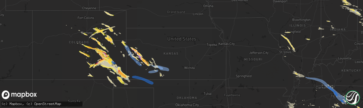
Hail Map in Kansas on July 20, 2023
The weather event in Kansas on July 20, 2023 includes Hail, Wind, and Tornado maps. 22 states and 1,246 cities were impacted and suffered possible damage. The total estimated number of properties impacted is 2,275.
Hail
Wind
Tornado
2,275
Estimated number of impacted properties by a 1.00" hail or larger1,787
Estimated number of impacted properties by a 1.75" hail or larger1,832
Estimated number of impacted properties by a 2.50" hail or largerStorm reports in Kansas
Kansas
| Date | Description |
|---|---|
| 07/20/20236:26 PM CDT | Asos station kddc dodge city regional airport. |
| 07/20/20236:05 PM CDT | A local report indicates 70 MPH wind near 2 NW Dodge City |
| 07/20/20235:36 PM CDT | Report from mping: half dollar |
| 07/20/20235:25 PM CDT | A local report indicates 60 MPH wind near 6 N Ingalls |
| 07/20/20235:00 PM CDT | Asos station kgck garden city. |
| 07/20/20234:48 PM CDT | A local report indicates 2.50 inch wind near 10 NE Garden City |
| 07/20/20234:30 PM CDT | A local report indicates 1.00 inch wind near 4 W Lydia |
| 07/20/20234:20 PM CDT | A home lost some shingles and some flying debris struck a propane tank causing a gas leak. |
| 07/20/20234:15 PM CDT | Several power poles down at this location. Image of this damage also showed hail-covered field with hail fog. |
| 07/20/20234:15 PM CDT | Picture of flipped center pivot at this location on gano rd... About a mile east of highway 83 where power poles were down. There was extensive wind and hail damage to |
| 07/20/20234:10 PM CDT | A dozen power poles down around the intersection of kansas rd and finney scott rd due to possible tornado. |
| 07/20/20233:45 PM CDT | Facebook messenger. |
| 07/20/20233:43 PM CDT | A local report indicates 2.50 inch wind near 2 WNW Modoc |
| 07/20/20233:00 PM CDT | Window damage to home also reported. |
| 07/20/20233:00 PM CDT | Reports of damage to irrigation equipment and sheds. |
| 07/20/202312:55 AM CDT | Mesonet station up835 3.0 w kingsdown |
| 07/20/202312:45 AM CDT | Mesonet station dw9907 bloom. |
| 07/20/202312:31 AM CDT | Awos station klbl liberal. |
| 07/20/202312:25 AM CDT | A local report indicates 70 MPH wind near Liberal |
| 07/20/202312:20 AM CDT | Delayed report of railroad crossing arm broken off at main street in tribune. |
| 07/19/202311:55 PM CDT | Awos station khqg hugoton. |
| 07/19/202311:15 PM CDT | Mesonet station lkuk1 lakin. |
| 07/19/202310:25 PM CDT | Corrects previous tstm wnd dmg report from tribune. Delayed report of railroad crossing arm broken off at main street in tribune. Time is estimated using radar and near |
| 07/19/202310:22 PM CDT | The awos in tribune |
| 07/19/202310:18 PM CDT | A local report indicates 58 MPH wind near 6 E Tribune |
| 07/19/202310:14 PM CDT | A local report indicates 69 MPH wind near 5 S Tribune |
| 07/19/202310:11 PM CDT | Tribune awos reported at wind gust of 64 mph at 911 pm mdt. |
| 07/19/20239:40 PM CDT | Mesonet station kwlk1 wallace. Wind gust measured at 2 meter height. Wind direction from the north-northeast. |
All States Impacted by Hail Map on July 20, 2023
Cities Impacted by Hail Map on July 20, 2023
- Bonne Terre, MO
- Farmington, MO
- Roodhouse, IL
- White Hall, IL
- Greenfield, IL
- Hettick, IL
- New Berlin, IL
- Carlinville, IL
- Shipman, IL
- Gillespie, IL
- Paducah, KY
- Brookport, IL
- Ledbetter, KY
- Gilbertsville, KY
- Smithland, KY
- Calvert City, KY
- Grand Rivers, KY
- Kuttawa, KY
- Eddyville, KY
- Sterling, CO
- Iliff, CO
- Princeton, KY
- Cadiz, KY
- Cerulean, KY
- Gracey, KY
- Crofton, KY
- Hopkinsville, KY
- Fleming, CO
- Pembroke, KY
- Trenton, KY
- Elkton, KY
- Guthrie, KY
- Clarksville, TN
- Allensville, KY
- Adams, TN
- Olmstead, KY
- Springfield, TN
- Cedar Hill, TN
- Adairville, KY
- Greenbrier, TN
- White House, TN
- Goodlettsville, TN
- Hendersonville, TN
- Cottontown, TN
- Madison, TN
- Gallatin, TN
- Bannister, MI
- Brant, MI
- Elsie, MI
- Ashley, MI
- Oakley, MI
- Henderson, MI
- Chesaning, MI
- Old Hickory, TN
- Mount Juliet, TN
- Lebanon, TN
- Hermitage, TN
- Stewart, TN
- Metropolis, IL
- Jacksonville, IL
- Murrayville, IL
- Carlyle, IL
- Winchester, IL
- Sheridan, MI
- French Village, MO
- Sedgewickville, MO
- Friedheim, MO
- Perryville, MO
- Greenville, MI
- Edwardsville, IL
- Padroni, CO
- Waterloo, IL
- Grand Chain, IL
- Sainte Genevieve, MO
- Saint Mary, MO
- Stanton, MI
- Hersey, MI
- Reed City, MI
- Evart, MI
- Oak Ridge, MO
- Daisy, MO
- Patton, MO
- Ullin, IL
- Olmsted, IL
- Kevil, KY
- Pulaski, IL
- Alexander, IL
- Jackson, MO
- Cape Girardeau, MO
- Jonesboro, IL
- McClure, IL
- Lake City, PA
- East Springfield, PA
- Girard, PA
- Osage Beach, MO
- Kaiser, MO
- Linn Creek, MO
- Thebes, IL
- Tamms, IL
- Kirk, CO
- Lakeview, MI
- Pocahontas, IL
- Crossville, TN
- Oak Grove, KY
- Pentwater, MI
- Ludington, MI
- Orlinda, TN
- Benld, IL
- Chesterfield, IL
- Sidney, MI
- Fredericktown, MO
- Russellville, KY
- Howard City, MI
- Morley, MI
- Fort Campbell, KY
- Potosi, MO
- Alhambra, IL
- Livingston, IL
- Staunton, IL
- New Douglas, IL
- Baxter, TN
- Gowen, MI
- De Soto, MO
- Valles Mines, MO
- Aviston, IL
- Festus, MO
- Bloomsdale, MO
- Rockford, MI
- Merino, CO
- Lake, MI
- Breese, IL
- Highland, IL
- Palmyra, IL
- Sawyerville, IL
- Mount Olive, IL
- Golden Eagle, IL
- Bunker Hill, IL
- Wilsonville, IL
- Fenwick, MI
- Vestaburg, MI
- Six Lakes, MI
- Coral, MI
- Newaygo, MI
- Trufant, MI
- White Cloud, MI
- Crystal, MI
- Moro, IL
- Mounds, IL
- Olive Branch, IL
- Villa Ridge, IL
- Brumley, MO
- La Center, KY
- Barlow, KY
- Dongola, IL
- West Paducah, KY
- Karnak, IL
- Cypress, IL
- Stoneham, CO
- Park Hills, MO
- Murfreesboro, TN
- New Lothrop, MI
- Owosso, MI
- Montrose, MI
- Corunna, MI
- Dewitt, MI
- Bath, MI
- Laingsburg, MI
- Flint, MI
- Clio, MI
- Flushing, MI
- Lennon, MI
- Swartz Creek, MI
- Mount Morris, MI
- Fairview, PA
- Erie, PA
- McKean, PA
- Harborcreek, PA
- North East, PA
- Ripley, NY
- Burton, MI
- Davison, MI
- Genesee, MI
- Schoolcraft, MI
- Vicksburg, MI
- Lapeer, MI
- Lascassas, TN
- Auburntown, TN
- Watertown, TN
- Milton, TN
- Liberty, TN
- Alexandria, TN
- Dowelltown, TN
- Smithville, TN
- Woodbury, TN
- Readyville, TN
- Mcminnville, TN
- Bradyville, TN
- Morrison, TN
- Saint Johns, MI
- Ovid, MI
- Durand, MI
- Holt, MI
- Leslie, MI
- Mason, MI
- Dansville, MI
- Williamston, MI
- Webberville, MI
- Fowlerville, MI
- Stockbridge, MI
- Brighton, MI
- Gregory, MI
- Howell, MI
- Pinckney, MI
- Capac, MI
- Imlay City, MI
- Allenton, MI
- Almont, MI
- Dryden, MI
- Otisville, MI
- Grand Blanc, MI
- Goodrich, MI
- Atlas, MI
- Oxford, MI
- Metamora, MI
- Hadley, MI
- Ortonville, MI
- Columbiaville, MI
- Detroit, MI
- Highland Park, MI
- Ferndale, MI
- Warren, MI
- Hamtramck, MI
- Hazel Park, MI
- South Bend, IN
- Mishawaka, IN
- Osceola, IN
- Eastpointe, MI
- Saint Clair Shores, MI
- Roseville, MI
- Harper Woods, MI
- Avoca, MI
- Emmett, MI
- Jeddo, MI
- North Street, MI
- Clinton Township, MI
- Harrison Township, MI
- Elkhart, IN
- Goshen, IN
- Clarkston, MI
- Rock Island, TN
- Fort Gratiot, MI
- Center Line, MI
- Bennett, CO
- Columbus, MI
- Saint Clair, MI
- Casco, MI
- East China, MI
- Marysville, MI
- Divide, CO
- Woodland Park, CO
- Green Mountain Falls, CO
- Cascade, CO
- Colorado Springs, CO
- Attica, MI
- Romeo, MI
- Washington, MI
- Leonard, MI
- Rochester, MI
- Oakland, MI
- Ray, MI
- Macomb, MI
- Utica, MI
- Armada, MI
- New Baltimore, MI
- New Haven, MI
- Harsens Island, MI
- Fair Haven, MI
- Algonac, MI
- Marine City, MI
- Richmond, MI
- Smiths Creek, MI
- Goodells, MI
- Memphis, MI
- Yale, MI
- Port Huron, MI
- Manitou Springs, CO
- Middlebury, IN
- Millersburg, IN
- Elizabeth, CO
- Albion, PA
- Cranesville, PA
- Edinboro, PA
- Kiowa, CO
- West Springfield, PA
- Ypsilanti, MI
- Ann Arbor, MI
- Canton, MI
- Belleville, MI
- Wayne, MI
- Dexter, MI
- Chelsea, MI
- Peyton, CO
- Elbert, CO
- Strasburg, CO
- Byers, CO
- Fort Morgan, CO
- Calhan, CO
- Ramah, CO
- Wallace, KS
- Sharon Springs, KS
- Leoti, KS
- Winona, KS
- Marienthal, KS
- Scott City, KS
- Simla, CO
- Boncarbo, CO
- Trinidad, CO
- Waterford, PA
- Holcomb, KS
- Garden City, KS
- Deerfield, KS
- Yoder, CO
- Union City, PA
- Walsenburg, CO
- Lakin, KS
- Wakeman, OH
- Oberlin, OH
- Chardon, OH
- Brookpark, OH
- Montville, OH
- Norwalk, OH
- Jefferson, OH
- Wellington, OH
- Beachwood, OH
- Grafton, OH
- New London, OH
- Kingsville, OH
- Independence, OH
- Berea, OH
- Springboro, PA
- Rock Creek, OH
- Pierpont, OH
- North Fairfield, OH
- Lagrange, OH
- Conneaut, OH
- Gates Mills, OH
- Olmsted Falls, OH
- Chesterland, OH
- Collins, OH
- Cleveland, OH
- Thompson, OH
- Columbia Station, OH
- Martin, OH
- Graytown, OH
- Oak Harbor, OH
- Curtice, OH
- Matheson, CO
- Denver, CO
- Morrison, CO
- Golden, CO
- Ingalls, KS
- Wattsburg, PA
- Littleton, CO
- Englewood, CO
- Canon City, CO
- Penrose, CO
- Fort Wayne, IN
- Yoder, IN
- Hoagland, IN
- Decatur, IN
- Monroeville, IN
- Ohio City, OH
- Convoy, OH
- Van Wert, OH
- Rush, CO
- Fowler, CO
- Chatsworth, GA
- Dalton, GA
- Ellijay, GA
- Calhoun, GA
- Resaca, GA
- Ranger, GA
- Talking Rock, GA
- Fairmount, GA
- Waleska, GA
- Jasper, GA
- Ball Ground, GA
- Canton, GA
- Alpharetta, GA
- Tate, GA
- Suwanee, GA
- Gainesville, GA
- Marble Hill, GA
- Dawsonville, GA
- Flowery Branch, GA
- Cumming, GA
- Buford, GA
- Corry, PA
- Cimarron, KS
- Florence, CO
- Wapakoneta, OH
- Lima, OH
- Manzanola, CO
- Harrod, OH
- Lafayette, OH
- Ada, OH
- Alger, OH
- Ordway, CO
- Hugo, CO
- Roggen, CO
- Mentor, OH
- Painesville, OH
- Grand River, OH
- Bluffton, OH
- Pueblo, CO
- Forest, OH
- Dunkirk, OH
- Sugar City, CO
- Rocky Ford, CO
- Olney Springs, CO
- Oakwood, GA
- Pendergrass, GA
- Talmo, GA
- Hoschton, GA
- Braselton, GA
- Jefferson, GA
- Dacula, GA
- Auburn, GA
- Lawrenceville, GA
- Winder, GA
- Statham, GA
- Bogart, GA
- Athens, GA
- Watkinsville, GA
- Colbert, GA
- Arnoldsville, GA
- Lexington, GA
- Crawford, GA
- Winterville, GA
- Nicholson, GA
- Lakeview, OH
- Huntsville, OH
- Belle Center, OH
- La Junta, CO
- Roundhead, OH
- Karval, CO
- Columbus, PA
- Bear Lake, PA
- Spring Creek, PA
- Youngsville, PA
- Pittsfield, PA
- Sugar Grove, PA
- Warren, PA
- Dodge City, KS
- Wright, KS
- Avon, OH
- Westlake, OH
- Bay Village, OH
- Rocky River, OH
- Arlington, CO
- North Olmsted, OH
- Model, CO
- Deer Trail, CO
- Russell, PA
- Spearville, KS
- Stephens, GA
- Rayle, GA
- Washington, GA
- Byron, MI
- Perry, MI
- Saint Charles, MI
- Central City, CO
- Black Hawk, CO
- Toney, AL
- Athens, AL
- Lancaster, TN
- South Lyon, MI
- Commerce Township, MI
- Downey, ID
- Lake Orion, MI
- South Pittsburg, TN
- Tracy City, TN
- Sequatchie, TN
- Monteagle, TN
- Three Rivers, MI
- Constantine, MI
- Dimondale, MI
- Eaton Rapids, MI
- Potterville, MI
- Wartrace, TN
- Shelbyville, TN
- Normandy, TN
- Aguilar, CO
- Walling, TN
- Copperhill, TN
- Blue Ridge, GA
- McCaysville, GA
- Ashtabula, OH
- Suches, GA
- Dahlonega, GA
- Belvidere, TN
- Huntland, TN
- Parker, CO
- Flintstone, GA
- Sparta, TN
- Quebeck, TN
- Linden, MI
- Woodrow, CO
- Akron, CO
- Edon, OH
- Montpelier, OH
- East Lansing, MI
- Okemos, MI
- Haslett, MI
- Laotto, IN
- Auburn, IN
- Leo, IN
- Garrett, IN
- Huntertown, IN
- Evergreen, CO
- Waterford, MI
- Farmington, MI
- Novi, MI
- Livonia, MI
- Northville, MI
- Springport, MI
- Onondaga, MI
- Olivet, MI
- Rives Junction, MI
- Jackson, MI
- Bellevue, MI
- Charlotte, MI
- Pulaski, TN
- Prospect, TN
- Leoma, TN
- Goodspring, TN
- Maxwell, NM
- Raton, NM
- Cross Plains, TN
- West Lafayette, IN
- Lafayette, IN
- Westpoint, IN
- Hollytree, AL
- Princeton, AL
- Estillfork, AL
- New Market, AL
- Angola, IN
- Sterling Heights, MI
- Weston, CO
- Saline, MI
- Neoga, IL
- Trilla, IL
- Windsor, IL
- Strasburg, IL
- Clermont, GA
- Cornelia, GA
- Lula, GA
- Alto, GA
- Trenton, GA
- Morganton, GA
- Mineral Bluff, GA
- Darlington, IN
- Albion, IN
- Pierceton, IN
- Larwill, IN
- Kimmell, IN
- Cromwell, IN
- North Webster, IN
- South Whitley, IN
- Mendon, MI
- Antwerp, OH
- Woodburn, IN
- Grabill, IN
- Harlan, IN
- Manning, SC
- Manchester, TN
- Epworth, GA
- Tampa, FL
- Brandon, FL
- Riverview, FL
- Fraser, MI
- Redford, MI
- Tullahoma, TN
- Laramie, WY
- Fowler, MI
- Maple Rapids, MI
- Georgetown, IL
- Westville, IL
- Saint Marys, OH
- Chattanooga, TN
- Whiteside, TN
- Cayuga, IN
- Decatur, TN
- Dayton, TN
- Kremmling, CO
- Granger, IN
- Milford, IN
- Leesburg, IN
- Turtletown, TN
- Benton, TN
- Calhoun, TN
- Reliance, TN
- Riceville, TN
- Charleston, TN
- Old Fort, TN
- Delano, TN
- Spencerville, IN
- Lansing, MI
- Madison, AL
- Huntsville, AL
- Harvest, AL
- Centreville, MI
- Jones, MI
- Ridge Farm, IL
- Kingman, IN
- Dana, IN
- Catlin, IL
- Indianola, IL
- Etna Green, IN
- Winona Lake, IN
- Arcola, IN
- Ossian, IN
- Warsaw, IN
- Roanoke, IN
- Columbia City, IN
- New Haven, IN
- Buena Vista, NM
- Terre Haute, IN
- Troy, MI
- New Paris, IN
- Syracuse, IN
- Ligonier, IN
- Mount Clemens, MI
- Carson City, MI
- Hubbardston, MI
- Clayton, IN
- Stilesville, IN
- Monrovia, IN
- Claypool, IN
- Fenton, MI
- Holly, MI
- Davisburg, MI
- West Terre Haute, IN
- Nappanee, IN
- Avilla, IN
- New Carlisle, IN
- Churubusco, IN
- Kendallville, IN
- Wawaka, IN
- Topeka, IN
- Lake George, CO
- Bloomfield Hills, MI
- Birmingham, MI
- Clawson, MI
- Franklin, MI
- West Bloomfield, MI
- Royal Oak, MI
- Southfield, MI
- Whitwell, TN
- New Boston, MI
- Allen Park, MI
- Dearborn Heights, MI
- Dearborn, MI
- Romulus, MI
- Melvindale, MI
- Taylor, MI
- Inkster, MI
- Westland, MI
- Farmdale, OH
- Cortland, OH
- Watkins, CO
- Aurora, CO
- Portland, TN
- Otterbein, IN
- Plymouth, MI
- Guild, TN
- Crawfordsville, IN
- Thorntown, IN
- Advance, IN
- Lebanon, IN
- Jamestown, IN
- Petersburg, TN
- Mulberry, TN
- Fayetteville, TN
- Munith, MI
- Grass Lake, MI
- Kelso, TN
- Flintville, TN
- Elora, TN
- Sherwood, TN
- Silver Point, TN
- Franktown, CO
- Fort Payne, AL
- Mentone, AL
- Valley Head, AL
- Castle Rock, CO
- Rock River, WY
- Middleton, MI
- Hollywood, AL
- Stevenson, AL
- Scottsboro, AL
- Hazel Green, AL
- Fackler, AL
- Meridianville, AL
- Woodville, AL
- Flat Rock, AL
- Sumner, MI
- North Bloomfield, OH
- Riverview, MI
- Trenton, MI
- Grosse Ile, MI
- Wyandotte, MI
- Southgate, MI
- Florissant, CO
- Lynchburg, TN
- Pikeville, TN
- Perrinton, MI
- Blairsville, GA
- Athens, TN
- Cleveland, TN
- Georgetown, TN
- Mooresville, IN
- Belfast, TN
- Sherwood, MI
- Leonidas, MI
- Colon, MI
- Pisgah, AL
- Lowell, MI
- Saranac, MI
- New Knoxville, OH
- New Bremen, OH
- Celina, OH
- Marshall, MI
- Bancroft, MI
- Cleveland, GA
- Bourbon, IN
- Cherry Log, GA
- Ithaca, MI
- Grand Ledge, MI
- Pewamo, MI
- Muir, MI
- Beersheba Springs, TN
- Altamont, TN
- Genoa, CO
- Limon, CO
- Las Animas, CO
- Lincoln Park, MI
- Bucklin, KS
- Offerle, KS
- Mullinville, KS
- Ford, KS
- Greensburg, KS
- Haviland, KS
- Kinsley, KS
- Irvine, PA
- Clarendon, PA
- Sheffield, PA
- Tionesta, PA
- Ludlow, PA
- Lewis Run, PA
- James City, PA
- Marienville, PA
- Mount Jewett, PA
- Kane, PA
- Tiona, PA
- Wilcox, PA
- Johnsonburg, PA
- Ridgway, PA
- Smethport, PA
- Saint Marys, PA
- Hazel Hurst, PA
- Coats, KS
- Pratt, KS
- Cheraw, CO
- Arriba, CO
- Flagler, CO
- Hasty, CO
- Piqua, OH
- Troy, OH
- Covington, OH
- Emporium, PA
- Kersey, PA
- Force, PA
- Benezett, PA
- Byrnedale, PA
- Weedville, PA
- Clearfield, PA
- Crosby, PA
- Driftwood, PA
- Penfield, PA
- Frenchville, PA
- Kim, CO
- Middlebranch, OH
- Canton, OH
- North Canton, OH
- Alliance, OH
- Louisville, OH
- Paris, OH
- Robertsville, OH
- East Canton, OH
- Minerva, OH
- Homeworth, OH
- Kensington, OH
- East Rochester, OH
- Carrollton, OH
- Mechanicstown, OH
- Salem, OH
- Salineville, OH
- Beloit, OH
- Lisbon, OH
- Summitville, OH
- Hanoverton, OH
- Woodland, PA
- Karthaus, PA
- Sinnamahoning, PA
- Beech Creek, PA
- Pottersdale, PA
- Westport, PA
- Morrisdale, PA
- Wilmington, OH
- Jamestown, OH
- Sabina, OH
- Jeffersonville, OH
- Washington Court House, OH
- Bigler, PA
- Mineral Springs, PA
- West Decatur, PA
- Hammondsville, OH
- Wellsville, OH
- Burlington, CO
- Arapahoe, CO
- Lamar, CO
- Pritchett, CO
- Springfield, CO
- Julian, PA
- Philipsburg, PA
- Drifting, PA
- Grassflat, PA
- Snow Shoe, PA
- Winburne, PA
- Allport, PA
- Hawk Run, PA
- Clarence, PA
- Wallaceton, PA
- Munson, PA
- Lanse, PA
- Kylertown, PA
- Moshannon, PA
- Osceola Mills, PA
- Port Matilda, PA
- Bellefonte, PA
- State College, PA
- Fleming, PA
- Orviston, PA
- Walsh, CO
- Two Buttes, CO
- Langston, AL
- Guntersville, AL
- Albertville, AL
- Groveoak, AL
- Geraldine, AL
- Vilas, CO
- Weskan, KS
- Tribune, KS
- University Park, PA
- Crossville, AL
- Syracuse, KS
- Campo, CO
- Elkhart, KS
- Goodwell, OK
- Boise City, OK
- Keyes, OK
- Hudson, OH
- Twinsburg, OH
- Northfield, OH
- Macedonia, OH
- Bellaire, OH
- Saint Clairsville, OH
- Jacobsburg, OH
- Brecksville, OH
- Broadview Heights, OH
- Strongsville, OH
- Carlton, GA
- Elberton, GA
- Orwell, OH
- Idledale, CO
- Otis, CO
- Cedartown, GA
- Archbold, OH
- Cope, CO
- Anton, CO
- West Unity, OH
- West Liberty, OH
- Rosewood, OH
- East Liberty, OH
- Plain City, OH
- Conover, OH
- North Lewisburg, OH
- Cable, OH
- Saint Paris, OH
- Irwin, OH
- Zanesfield, OH
- Marysville, OH
- Urbana, OH
- Milford Center, OH
- Woodstock, OH
- De Graff, OH
- Mingo, OH
- Glen Easton, WV
- Cameron, WV
- Moundsville, WV
- Proctor, WV
- Lawrenceburg, TN
- London, OH
- Jackson Center, OH
- Lewistown, OH
- Murrayville, GA
- Glen Dale, WV
- Dawson, AL
- Fyffe, AL
- Grant, AL
- Bancroft, ID
- Wren, OH
- Willshire, OH
- Mentone, IN
- Gadsden, AL
- Vienna, OH
- Brookfield, OH
- Centerville, PA
- Russia, OH
- Fletcher, OH
- Bradford, OH
- Houston, OH
- Versailles, OH
- Medina, OH
- Seville, OH
- Burkettsville, OH
- Rossburg, OH
- New Weston, OH
- Saint Henry, OH
- Fort Recovery, OH
- Waynesfield, OH
- Lakewood, OH
- North Ridgeville, OH
- Bedford, OH
- Edgefield, SC
- Jetmore, KS
- Agate, CO
- Clarks Mills, PA
- Hull, GA
- Huntington, IN
- Rockford, OH
- Markle, IN
- Mendon, OH
- Zanesville, IN
- Homer, GA
- Anna, OH
- Dayton, OH
- Keenesburg, CO
- Hudson, CO
- Brush, CO
- Section, AL
- New Hope, AL
- Gurley, AL
- Brownsboro, AL
- Owens Cross Roads, AL
- Madison, OH
- Geneva, OH
- Joes, CO
- Rome, OH
- Andover, OH
- Dorset, OH
- Myrtle Beach, SC
- North Royalton, OH
- Saint Stephen, SC
- Jamestown, SC
- Sidney, OH
- Sapello, NM
- New Vienna, OH
- Commerce, GA
- Comer, GA
- Clifton, ID
- Kit Carson, CO
- Lane, SC
- Pineville, SC
- New Hampshire, OH
- Rushsylvania, OH
- Russells Point, OH
- Unionville, TN
- Yorkshire, OH
- Centre, AL
- Leesburg, AL
- Danielsville, GA
- Williamsfield, OH
- Rockvale, TN
- Christiana, TN
- Henagar, AL
- Dutton, AL
- Boone, CO
- Oregonia, OH
- Pioneer, OH
- Leesburg, OH
- Greenville, PA
- Transfer, PA
- Parshall, CO
- Collinsville, AL
- Orlando, FL
- Longs, SC
- Farrell, PA
- West Middlesex, PA
- Wheatland, PA
- Hubbard, OH
- Hermitage, PA
- Kinsman, OH
- Cambridge Springs, PA
- Port Clinton, OH
- North Myrtle Beach, SC
- Avon Lake, OH
- Sheffield Lake, OH
- Elyria, OH
- Lorain, OH
- Maysville, GA
- Carnesville, GA
- Hilliard, OH
- Columbus, OH
- Litchfield, OH
- Bellefontaine, OH
- Lester, AL
- Greeleyville, SC
- Richwood, OH
- Middle Bass, OH
- Put In Bay, OH
- Lindon, CO
- Bell Buckle, TN
- Wesley Chapel, FL
- Cheyenne Wells, CO
- Mason, TN
- Drummonds, TN
- Osceola, AR
- Atoka, TN
- Munford, TN
- Brighton, TN
- Henning, TN
- Covington, TN
- Burlison, TN
- Dublin, OH
- Monroeville, OH
- Gillsville, GA
- Powell, OH
- Westerville, OH
- Punta Gorda, FL
- Hinckley, OH
- Clarksville, OH
- Waynesville, OH
- New Wilmington, PA
- Mercer, PA
- Ballard, WV
- Piedmont, AL
- Lancaster, OH
- Carroll, OH
- Pulaski, PA
- Kittanning, PA
- Austinburg, OH
- Zephyrhills, FL
- Dade City, FL
- Lewisburg, TN
- Port William, OH
- Haviland, OH
- Grover Hill, OH
- Sandusky, OH
- Columbus Grove, OH
- Beallsville, OH
- West Jefferson, OH
- Marietta, GA
- Fredonia, PA
- Sharpsville, PA
- Burghill, OH
- Xenia, OH
- Harveysburg, OH
- Chagrin Falls, OH
- Solon, OH
- Amherst, OH
- Richfield, OH
- Valley City, OH
- Brunswick, OH
- Ridgeway, OH
- Botkins, OH
- Montezuma, OH
- Uniopolis, OH
- Dola, OH
- Jenera, OH
- Pickerington, OH
- Reynoldsburg, OH
- Dallas, GA
- Jackson, TN
- Humboldt, TN
- Hugoton, KS
- Rolla, KS
- Turpin, OK
- Liberal, KS
- Kismet, KS
- Forgan, OK
- Gate, OK
- Laverne, OK
- Beaver, OK
- Texhoma, OK
- Maple Heights, OH
- Meade, KS
- Minneola, KS
- Fowler, KS
- Mattoon, IL
- Drummond, OK
- Lahoma, OK
- Enid, OK
- Waukomis, OK
- Fairmont, OK
- Covington, OK
- Garber, OK
- Perry, OK
- Rye, CO
- Cameron, SC
- Blairs Mills, PA
- Shade Gap, PA
- Oakland, TN
- Sheridan Lake, CO
- Burlington, WV
- Purgitsville, WV
- Romney, WV
- Beulah, CO
- Montezuma, KS
- Arlington, TN
- Stanton, TN
- Cordova, TN
- Rossville, TN
- Memphis, TN
- Millington, TN
- Eads, TN
- Somerville, TN
- Williston, TN
- Kimbolton, OH
- Keyser, WV
- Newburg, WV
- Independence, WV
- Reedsville, WV
- Kingwood, WV
- Georgetown, SC
- Colorado City, CO
- Sardis, TN
- Saltillo, TN
- Belmont, OH
- Enville, TN
- Lexington, TN
- Reagan, TN
- Bison, OK
- Hennessey, OK
- Fairfield, PA
- Orrtanna, PA
- Spring Run, PA
- Newburg, PA
- Grenville, NM
- Minor Hill, TN
- Willis, MI
- Mapleton Depot, PA
- Huntingdon, PA
- Medina, TN
- Fayetteville, PA
- Waynesboro, PA
- Chambersburg, PA
- Bath Springs, TN
- Clifton, TN
- Scotts Hill, TN
- Waynesboro, TN
- Bellwood, PA
- Hollidaysburg, PA
- Tyrone, PA
- Williamsburg, PA
- Fallentimber, PA
- Blandburg, PA
- Altoona, PA
- Swink, CO
- Hickory, KY
- Mayfield, KY
- Pierceville, KS
- Orrstown, PA
- Dry Run, PA
- Doylesburg, PA
- Orangeburg, SC
- Brownsville, TN
- Ripley, TN
- Mill Creek, PA
- Copeland, KS
- Alva, OK
- Blanchester, OH
- Medon, TN
- Pinson, TN
- Coldwater, KS
- Protection, KS
- Dysart, PA
- Osage, OK
- Dacoma, OK
- Pottsville, AR
- Russellville, AR
- Felt, OK
- Mannford, OK
- Terlton, OK
- Jennings, OK
- Hesston, PA
- Roswell, GA
- Cartersville, GA
- Tipton, PA
- Bedford, PA
- Orbisonia, PA
- Cleveland, OK
- Drumright, OK
- Yale, OK
- Acworth, GA
- Emerson, GA
- Shippensburg, PA
- Shirleysburg, PA
- Muskogee, OK
- Colt, AR
- Palestine, AR
- Forrest City, AR
- Dover, AR
- Clayton, NM
- Marianna, AR
- Brickeys, AR
- Hominy, OK
- James Creek, PA
- McVeytown, PA
- Mount Union, PA
- Meno, OK
- Carrier, OK
- West Memphis, AR
- Porter, OK
- Coweta, OK
- Atkins, AR
- Paint Rock, AL
- Trenton, AL
- Collierville, TN
- Germantown, TN
- Moscow, TN
- Menlo, GA
- Hattieville, AR
- Robinsonville, MS
- Parma, MI


