Hail Map in Minnesota on July 19, 2023
The weather event in Minnesota on July 19, 2023 includes Wind, Tornado, and Hail maps. 27 states and 569 cities were impacted and suffered possible damage. The total estimated number of properties impacted is 35,903.
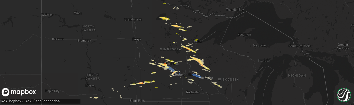
Wind
Tornado
Hail
35,903
Estimated number of impacted properties by a 1.00" hail or larger5,913
Estimated number of impacted properties by a 1.75" hail or larger659
Estimated number of impacted properties by a 2.50" hail or largerStorm reports in Minnesota
Minnesota
| Date | Description |
|---|---|
| 07/19/20236:55 PM CDT | Late lsr - trained spotter reported large tree branches and tree down near wedgewood park. Photos were provided via email. Time estimated via radar. |
| 07/19/20236:55 PM CDT | Late lsr - trained spotter reported downed tree blocking roadway in willernie... Mn. Time estimated via radar. |
| 07/19/20236:45 PM CDT | Asos station kmic crystal ap. |
| 07/19/20236:33 PM CDT | Also measured 62 mph at 630 pm. |
| 07/19/20236:15 PM CDT | Small 5 inch diameter tree down blown down facing west. Time estimated by radar. |
| 07/19/20236:12 PM CDT | Report from mping: quarter |
| 07/19/20236:10 PM CDT | Several 8 to 10 inch diameter aspen trees down pointing from northwest and southeast. Time estimated from radar. |
| 07/19/20236:09 PM CDT | Report of a tightly rotating mesocyclone and possible wind or tornado damage on highway 169 approximately 2 miles east of calumet. Location approximate. Time estimated |
| 07/19/20236:09 PM CDT | Quarter size hail. Location approximate. Time estimated by radar. |
| 07/19/20236:04 PM CDT | Late lsr - emergency manager emailed photo of large tree that fell on unoccupied vehicle in atwater... Mn and additionally reported other areas within the city of atwat |
| 07/19/20236:00 PM CDT | A local report indicates 1.75 inch wind near Waverly |
| 07/19/20235:33 PM CDT | A local report indicates 1.00 inch wind near 12 N Grand Rapids |
| 07/19/20235:26 PM CDT | Six to eight inch tree branches down with time estimated based on radar. |
| 07/19/20235:20 PM CDT | Report from social media with photo. |
| 07/19/20235:15 PM CDT | Relayed via stearns county em. |
| 07/19/20235:05 PM CDT | A local report indicates 1.50 inch wind near Bruno |
| 07/19/20234:53 PM CDT | Report via broadcast meteorologist viewer with photo. Time estimated from radar. |
| 07/19/20234:52 PM CDT | A local report indicates 1.00 inch wind near 3 E Sturgeon Lake |
| 07/19/20234:51 PM CDT | A local report indicates 1.00 inch wind near 1 ENE Sturgeon Lake |
| 07/19/20234:48 PM CDT | A local report indicates 1.50 inch wind near 3 S Albany |
| 07/19/20234:47 PM CDT | A local report indicates 1.75 inch wind near 5 S Albany |
| 07/19/20234:47 PM CDT | Photo via social media with measuring tape. Time estimated from radar. |
| 07/19/20234:35 PM CDT | Photo was taken of quarter sized hail and was reported to be slightly larger than a quarter. |
| 07/19/20234:25 PM CDT | Numerous 3 to 4 inch diameter branches down... Generally 5 to 10 feet long. |
| 07/19/20234:25 PM CDT | Hail melted quickly but some piles were still around as of 445 pm. |
| 07/19/20234:15 PM CDT | Report from mping: quarter |
| 07/19/20234:15 PM CDT | Report via social media with video. Observer reports they have broken windows and a dented car. Time estimated from radar. |
| 07/19/20234:10 PM CDT | Report from social media of numerous 2 to 2.5 inch diameter hailstones with measuring tape photo. |
| 07/19/20234:05 PM CDT | Report via social media with photo. Time estimated from radar. |
| 07/19/20234:03 PM CDT | Social media report. |
| 07/19/20233:50 PM CDT | Spotter reports dime to quarter sized hail. |
| 07/19/20233:37 PM CDT | Lots of damage to vehicle due to large hail. |
| 07/19/20233:30 PM CDT | Social media picture. |
| 07/19/20233:28 PM CDT | Social media picture. |
| 07/19/20233:26 PM CDT | A local report indicates 1.00 inch wind near 4 W Kelliher |
| 07/19/20233:24 PM CDT | Social media picture. |
| 07/19/20233:23 PM CDT | Hail varied from pea size to golf ball size. |
| 07/19/20233:15 PM CDT | Size estimated from pictures. Time estimated from radar. |
| 07/19/20233:13 PM CDT | A local report indicates 1.00 inch wind near Saum |
| 07/19/20233:08 PM CDT | Quarter size hail report from mping. |
| 07/19/20233:02 PM CDT | Half dollar sized hail reported by the public 5 sw baudette. |
| 07/19/20232:55 PM CDT | Hailstone was measured next to a quarter. Spotter notes that the hail was slightly larger than the quarter. |
| 07/18/20237:52 PM CDT | A local report indicates 1.00 inch wind near Inver Grove Height |
| 07/18/20237:32 PM CDT | Late lsr - large tree branches down. Time estimated via radar. |
| 07/18/20237:29 PM CDT | Late lsr - large tree down near the intersection of peony ln and old rockford rd. Photo shared via social media. Time estimated via radar. |
| 07/18/20237:15 PM CDT | Report sent in via social media. |
| 07/18/20237:00 PM CDT | Spotter reports nickel to quarter sized hail. |
| 07/18/20237:00 PM CDT | Numerous hailstones with the largest stones up to quarter size. |
All States Impacted by Hail Map on July 19, 2023
Cities Impacted by Hail Map on July 19, 2023
- Kiahsville, WV
- Harts, WV
- Dunlow, WV
- Ranger, WV
- Midkiff, WV
- Spurlockville, WV
- Alkol, WV
- Branchland, WV
- Griffithsville, WV
- Yawkey, WV
- Sumerco, WV
- Wilsondale, WV
- Fort Gay, WV
- Crum, WV
- Rocky Mount, NC
- Battleboro, NC
- Whitakers, NC
- Nashville, NC
- Wood, SD
- Presho, SD
- Draper, SD
- Fulton, KY
- Clinton, KY
- Arlington, KY
- Bardwell, KY
- Wickliffe, KY
- Cunningham, KY
- Sullivan, MO
- Cairo, IL
- Miller City, IL
- Federalsburg, MD
- Bridgeville, DE
- Thebes, IL
- Olive Branch, IL
- Scott City, MO
- Lonedell, MO
- McClure, IL
- Arlington, SD
- Bruce, SD
- Cohasset, MN
- Grand Rapids, MN
- Mcgregor, MN
- Tamarack, MN
- Crosby, MN
- Emily, MN
- Aitkin, MN
- White, SD
- Toronto, SD
- Astoria, SD
- Hendricks, MN
- Ivanhoe, MN
- Floodwood, MN
- Kelliher, MN
- Ponemah, MN
- Blackduck, MN
- Northome, MN
- Colorado Springs, CO
- Usaf Academy, CO
- Peyton, CO
- Max, MN
- Deer River, MN
- Talmoon, MN
- Spring Lake, MN
- Marcell, MN
- Bigfork, MN
- Calhan, CO
- Yoder, CO
- Rush, CO
- Minneota, MN
- Marshall, MN
- Sturgeon Lake, MN
- Bovey, MN
- Kettle River, MN
- Moose Lake, MN
- Grantsburg, WI
- Hinckley, MN
- Danbury, WI
- Webster, WI
- Chugwater, WY
- Siren, WI
- Hawk Springs, WY
- Kerrick, MN
- Bruno, MN
- Yoder, WY
- Veteran, WY
- Torrington, WY
- Starbuck, MN
- Glenwood, MN
- Paynesville, MN
- Freeport, MN
- Albany, MN
- Avon, MN
- Glendo, WY
- Cheyenne, WY
- Shell Lake, WI
- Frederic, WI
- Nashwauk, MN
- Melrose, MN
- Spooner, WI
- Hertel, WI
- Saint Martin, MN
- Richmond, MN
- Montevideo, MN
- Kerkhoven, MN
- Clara City, MN
- Maynard, MN
- Raymond, MN
- Murdock, MN
- Sandstone, MN
- Barronett, WI
- Bowlus, MN
- Holdingford, MN
- Royalton, MN
- Rice, MN
- Sartell, MN
- Sauk Rapids, MN
- Foley, MN
- Clear Lake, MN
- Princeton, MN
- Oak Park, MN
- Boone, CO
- Olney Springs, CO
- Ordway, CO
- Sugar City, CO
- Sarona, WI
- Cumberland, WI
- Ramah, CO
- Rice Lake, WI
- Brooten, MN
- Belgrade, MN
- Cold Spring, MN
- Watkins, MN
- Kimball, MN
- South Haven, MN
- Clearwater, MN
- Annandale, MN
- Hartville, WY
- Model, CO
- Roy, NM
- Gladstone, NM
- Grenville, NM
- Haugen, WI
- Buffalo, MN
- Montrose, MN
- Delano, MN
- Waverly, MN
- Howard Lake, MN
- Maple Lake, MN
- Eden Valley, MN
- Pengilly, MN
- Conchas Dam, NM
- Barron, WI
- Cameron, WI
- Morrill, NE
- Harrison, NE
- Hibbing, MN
- Lingle, WY
- Jay Em, WY
- Wheatland, WY
- Guernsey, WY
- Goodland, MN
- Chadron, NE
- Nashua, MN
- Kadoka, SD
- Midland, SD
- Fort Pierre, SD
- Okaton, SD
- Warner, SD
- Bluffton, MN
- Sebeka, MN
- Pine River, MN
- Pierpont, SD
- Wadena, MN
- Highmore, SD
- New Effington, SD
- New York Mills, MN
- Sisseton, SD
- Blunt, SD
- Holabird, SD
- Staples, MN
- Wanblee, SD
- Stratford, SD
- Andover, SD
- Fairmount, ND
- Dalton, MN
- Rosholt, SD
- Pierre, SD
- Underwood, MN
- Remer, MN
- Northville, SD
- Rockham, SD
- Porcupine, SD
- Roslyn, SD
- Mellette, SD
- Cresbard, SD
- Longville, MN
- Orient, SD
- Backus, MN
- Harrold, SD
- Crawford, NE
- Manderson, SD
- Kyle, SD
- Belvidere, SD
- Campbell, MN
- Conde, SD
- Groton, SD
- Eden, SD
- Tintah, MN
- Pine Ridge, SD
- Ottertail, MN
- Fergus Falls, MN
- Faulkton, SD
- Lake City, SD
- Henning, MN
- Battle Lake, MN
- Saint Michael, MN
- Hanover, MN
- Rogers, MN
- Minneapolis, MN
- Osseo, MN
- Maple Grove, MN
- Stratton, NE
- Trenton, NE
- Atwood, KS
- Brewster, KS
- Levant, KS
- Colby, KS
- Cyrus, MN
- Hancock, MN
- Morris, MN
- Carlton, MN
- Jacobson, MN
- Milaca, MN
- Herndon, KS
- Trementina, NM
- Montello, NV
- Ideal, GA
- Oglethorpe, GA
- Palisade, MN
- Mitchell, SD
- Fulton, SD
- Lake Benton, MN
- Elkton, SD
- Fremont, NC
- De Smet, SD
- Long Prairie, MN
- Swanville, MN
- Burtrum, MN
- Grey Eagle, MN
- Isle, MN
- McGrath, MN
- Milledgeville, GA
- Eatonton, GA
- Lagrange, GA
- Lanett, AL
- Squaw Lake, MN
- Echo, MN
- Wood Lake, MN
- Barnum, MN
- Hamill, SD
- Kennebec, SD
- Ideal, SD
- Winner, SD
- Ghent, MN
- Porter, MN
- Taunton, MN
- Cottonwood, MN
- Limon, CO
- Bonaire, GA
- Dry Branch, GA
- Kathleen, GA
- Warner Robins, GA
- Jeffersonville, GA
- Wessington Springs, SD
- Roscoe, MN
- Ocala, FL
- Cromwell, MN
- Ellaville, GA
- Raton, NM
- Des Moines, NM
- East Prairie, MO
- Americus, GA
- Lowry, MN
- Danville, GA
- Irwinton, GA
- Virgil, SD
- Wessington, SD
- Cusseta, AL
- Valley, AL
- Windsor, NC
- Sauk Centre, MN
- Elrosa, MN
- Belview, MN
- Brookings, SD
- Alpena, SD
- Winter Park, FL
- Stedman, NC
- Fayetteville, NC
- Folsom, NM
- Five Points, AL
- Garrison, UT
- New London, MN
- Plains, GA
- Woonsocket, SD
- Winter Springs, FL
- Casselberry, FL
- Hawkinsville, GA
- Orlando, FL
- Farwell, MN
- Saint Joseph, MN
- Tampa, FL
- Matheson, CO
- Mitchell, NE
- Fort Laramie, WY
- Chetek, WI
- Kim, CO
- Ludell, KS
- Edson, KS
- Bird City, KS
- McDonald, KS
- Mosquero, NM
- Weyerhaeuser, WI
- Tooele, UT
- New Auburn, WI
- Bruce, WI
- Oberlin, KS
- Duluth, MN
- Holcombe, WI
- Hammond, WI
- Baldwin, WI
- Wilson, WI
- Woodville, WI
- Roberts, WI
- Glenwood City, WI
- Menomonie, WI
- Knapp, WI
- Spring Valley, WI
- Inver Grove Heights, MN
- Saint Paul Park, MN
- South Saint Paul, MN
- Lamberton, MN
- Sanborn, MN
- Springfield, MN
- Ellsworth, WI
- Hager City, WI
- Saint Stephen, MN
- Alliance, NE
- Richlands, NC
- Campo, CO
- Grinnell, KS
- Stuart, NE
- Oneill, NE
- Prescott, WI
- Crofton, NE
- Fordyce, NE
- Park, KS
- Hoxie, KS
- Quinter, KS
- Oakley, KS
- Dalbo, MN
- Stanchfield, MN
- Welch, MN
- Revere, MN
- Hines, MN
- Pine City, MN
- Scotland, SD
- Selden, KS
- Watertown, MN
- Spencer, NE
- Lynch, NE
- Hastings, MN
- Cannon Falls, MN
- Gem, KS
- La Junta, CO
- Bloomer, WI
- Cornell, WI
- Park Valley, UT
- Garita, NM
- Rush City, MN
- Willow River, MN
- Birchwood, WI
- New Richmond, WI
- Clayton, NM
- Hawthorne, NV
- Cloquet, MN
- Kite, GA
- Swainsboro, GA
- Askov, MN
- Sheridan Lake, CO
- Mikana, WI
- Kenton, OK
- Pritchett, CO
- Fowler, CO
- Niobrara, NE
- Bloomfield, NE
- New Prague, MN
- Las Animas, CO
- Foxboro, WI
- Garfield, GA
- Twin City, GA
- Midville, GA
- Dresden, KS
- Merna, NE
- Anselmo, NE
- Millen, GA
- Dana, IA
- Yankton, SD
- Tabor, SD
- Saint Helena, NE
- Tyndall, SD
- Cottage Grove, MN
- Finlayson, MN
- Walsenburg, CO
- Hampton, MN
- Winsted, MN
- Rockford, MN
- Center, NE
- Verdigre, NE
- Sahuarita, AZ
- Green Valley, AZ
- Emigsville, PA
- Dover, PA
- York, PA
- Red Lion, PA
- Silver Lake, MN
- Lester Prairie, MN
- Glencoe, MN
- Mayer, MN
- New Germany, MN
- Sylvania, GA
- Bay City, WI
- Hamel, MN
- Loretto, MN
- Lesterville, SD
- Gabbs, NV
- Saint Cloud, MN
- Rexford, KS
- Jennings, KS
- Kensington, MN
- Litchfield, MN
- Portal, GA
- Grove City, MN
- Dalton, NE
- Bayard, NE
- Cokato, MN
- Dallas, WI
- Saint Peter, MN
- Le Sueur, MN
- Pittsville, WI
- Dodge City, KS
- Wright, KS
- Ford, KS
- Bucklin, KS
- Greensburg, KS
- Mullinville, KS
- Gove, KS
- Baudette, MN
- Littlefork, MN
- Mountain Iron, MN
- Chisholm, MN
- Kinney, MN
- Buhl, MN
- Jim Falls, WI
- Canon City, CO
- Guffey, CO
- Calumet, MN
- Ingalls, KS
- Freedom, OK
- Fall Creek, WI
- Downing, WI
- Montezuma, KS
- Copeland, KS
- Maiden Rock, WI
- Neillsville, WI
- Fairchild, WI
- Humbird, WI
- Black River Falls, WI
- Merrillan, WI
- Virginia, MN
- Loman, MN
- Red Wing, MN
- Garden City, KS
- Pratt, KS
- Cimarron, KS
- Haviland, KS
- Solon Springs, WI
- Ellis, KS
- Le Center, MN
- Iuka, KS
- Follett, TX
- Syracuse, KS
- Augusta, WI
- Ogallah, KS
- Turon, KS
- Stafford, KS
- Elk Mound, WI
- Kendall, KS
- Altoona, WI
- Eau Claire, WI
- Chippewa Falls, WI
- Cadott, WI
- Long Lake, MN
- Boyceville, WI
- Winona, KS
- Minneola, KS
- Ensign, KS
- Richfield, KS
- Eden Prairie, MN
- Maple Plain, MN
- Kincaid, KS
- Colony, KS
- Canadian, TX
- Burlington, KS
- Westphalia, KS
- Bronson, KS
- Wellington, KS
- Oxford, KS
- Belle Plaine, KS
- Winfield, KS
- Pleasanton, KS
- Phillipsburg, MO
- Long Lane, MO
- Babcock, WI
- Bolivar, MO
- Half Way, MO
- Polk, MO
- Iola, KS
- Blue Mound, KS
- Welda, KS
- Garnett, KS
- La Harpe, KS
- Moran, KS
- Camdenton, MO
- Buffalo, MO
- Carthage, TN
- Gainesboro, TN
- Pleasant Shade, TN
- Centerville, KS
- Parker, KS
- Mound City, KS
- El Dorado Springs, MO
- Walker, MO
- Collins, MO
- Mapleton, KS
- Humansville, MO
- Ashland, KS
- Westmoreland, TN
- Morrisville, MO
- Aldrich, MO
- Nevada, MO
- Englewood, KS
- Fargo, OK
- Neosho Falls, KS
- Le Roy, KS
- Shattuck, OK
- Flemington, MO
- Dunnegan, MO
- Quincy, MO
- Osceola, MO
- Rockville, MO
- Appleton City, MO
- Elkland, MO
- Amoret, MO
- Amsterdam, MO
- Roach, MO
- Weaubleau, MO
- Butler, MO
- Lebanon, MO
- Macks Creek, MO


