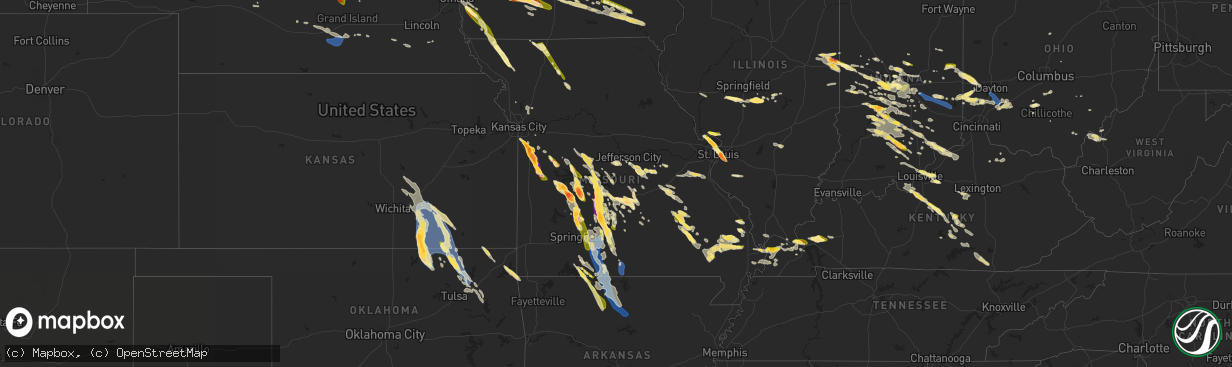
Hail Map in Missouri on July 17, 2023
The weather event in Missouri on July 17, 2023 includes Hail, Wind, and Tornado maps. 24 states and 1,163 cities were impacted and suffered possible damage. The total estimated number of properties impacted is 123,202.
Hail
Wind
Tornado
123,202
Estimated number of impacted properties by a 1.00" hail or larger56,510
Estimated number of impacted properties by a 1.75" hail or larger6,338
Estimated number of impacted properties by a 2.50" hail or largerStorm reports in Missouri
Missouri
| Date | Description |
|---|---|
| 07/17/20236:50 PM CDT | A local report indicates 2.75 inch wind near 5 S Garden City |
| 07/17/20236:49 PM CDT | Large tree uprooted and fell onto a garage causing moderate roof damage. Also a car sustained damage from the fallen tree. Numerous tree limbs blown down as well. Via p |
| 07/17/20236:45 PM CDT | Report from mping: hen egg |
| 07/17/20236:40 PM CDT | A local report indicates 4.00 inch wind near 3 W Garden City |
| 07/17/20236:38 PM CDT | Went from pea to quarter size. |
| 07/17/20236:38 PM CDT | Numerous reports of softball sized hail in garden city. Also received photo of a 5 inch hail stone measured with tape measure. |
| 07/17/20236:35 PM CDT | Hail 7 miles west of eldridge cracked windshield. |
| 07/17/20236:28 PM CDT | A local report indicates 2.75 inch wind near 3 ESE Harrisonville |
| 07/17/20236:24 PM CDT | Photos of several 3 inch hailstone from east harrisonville. Time estimated from radar. |
| 07/17/20236:24 PM CDT | A local report indicates 4.00 inch wind near 1 ESE Harrisonville |
| 07/17/20236:24 PM CDT | Corrects previous tstm wnd dmg report from 2 nne oermann. Large tree limb snapped off and landed on township ln. |
| 07/17/20236:13 PM CDT | Large tree limb snapped off and landed on township ln. |
| 07/17/20236:10 PM CDT | A local report indicates 1.00 inch wind near 2 NNE Roach |
| 07/17/20236:06 PM CDT | Report from mping: quarter |
| 07/17/20236:06 PM CDT | A local report indicates 1.50 inch wind near 2 WNW Camdenton |
| 07/17/20236:06 PM CDT | Hail had fallen about 20 minutes prior and was still measuring around 3 inches. Time estimated from radar. |
| 07/17/20236:03 PM CDT | A local report indicates 3.00 inch wind near 3 SSW Lake Winnebago |
| 07/17/20235:59 PM CDT | A local report indicates 1.00 inch wind near Camdenton |
| 07/17/20235:58 PM CDT | Large tree snapped off and pulled down nearby power line. |
| 07/17/20235:57 PM CDT | A local report indicates 1.00 inch wind near 4 ESE Williamsville |
| 07/17/20235:47 PM CDT | A local report indicates 1.00 inch wind near 1 N Raymore |
| 07/17/20235:20 PM CDT | Delayed report. Several reports of trees and limbs down in both the thornfield and theodosia areas. |
| 07/17/20235:15 PM CDT | Via social media picture. |
| 07/17/20235:01 PM CDT | Report from mping: 3-inch tree limbs broken; power poles broken. |
| 07/17/20234:59 PM CDT | Tree limbs up to 3 inches in diameter blown down. Pea size hail as well. |
| 07/17/20234:54 PM CDT | Lots numerous size and large limbs and trees down in bradleyville brown branch area. Time based on radar. |
| 07/17/20234:48 PM CDT | Large tree branch damaged tree house. |
| 07/17/20234:48 PM CDT | Large tree blown over. Time based on radar estimate. Via picture on social media. |
| 07/17/20234:42 PM CDT | Reports of trees down in ava area. |
| 07/17/20234:35 PM CDT | Trees down on highway t east of oldfield... Near the christian/douglas county line and on highway dd north of highway t... East of oldfield. |
| 07/17/20234:30 PM CDT | Trees down in mt zion. Time based on radar. |
| 07/17/20234:30 PM CDT | Large tree down. |
| 07/17/20234:05 PM CDT | Several reports of trees down in seymour. Shingles off roof of hotel. Sign blown down. |
| 07/17/20234:05 PM CDT | Measured gust to 71 mph at the office weather station. |
| 07/17/20234:00 PM CDT | Dime to quarter size hail. |
| 07/17/20233:50 PM CDT | Via social media report with picture. |
| 07/17/20233:45 PM CDT | A local report indicates 1.00 inch wind near Pleasant Hope |
| 07/17/20233:45 PM CDT | Delayed report. Via social media picture. Time based on radar estimate. |
| 07/17/20233:42 PM CDT | A local report indicates 1.00 inch wind near 5 WNW Duncan |
| 07/17/20233:40 PM CDT | A local report indicates 1.50 inch wind near 5 WNW Duncan |
| 07/17/20233:36 PM CDT | Via social media. |
| 07/17/20233:36 PM CDT | Report from mping: 1-inch tree limbs broken; shingles blown off. Time based on radar. |
| 07/17/20233:30 PM CDT | Quarter size hail. |
| 07/17/20233:30 PM CDT | Multiple reports of trees down across highway 32 east of bolivar near halfway. |
| 07/17/20233:30 PM CDT | Large trees blown over. |
| 07/17/20233:30 PM CDT | Delayed report through picture on social media of 2 inch hail. Time based on radar. |
| 07/17/20233:29 PM CDT | Public reported via social media. |
| 07/17/20233:20 PM CDT | Several reports of trees down in niangua area. |
| 07/17/20233:18 PM CDT | Trees down hwy m area. |
| 07/17/20233:00 PM CDT | Golf ball size hail. |
| 07/17/20232:55 PM CDT | Via social media picture. |
| 07/17/20232:48 PM CDT | Via social media picture. |
| 07/17/20232:45 PM CDT | A local report indicates 1.00 inch wind near 2 NE Florissant |
| 07/17/20232:44 PM CDT | Via twitter... Time estimated from radar. |
| 07/17/20232:44 PM CDT | At intersection of highway 367 and parker road. Via picture on facebook. |
| 07/17/20232:40 PM CDT | Report from mping: quarter |
| 07/17/20232:40 PM CDT | Quarter size hail. |
| 07/17/20232:40 PM CDT | Big tree down near route 64. Time based on radar. |
| 07/17/20232:36 PM CDT | Several trees down in park. Quarter size hail also. Time based on radar. |
| 07/17/20232:35 PM CDT | A local report indicates 1.25 inch wind near 4 N Florissant |
| 07/17/20232:06 PM CDT | A few golf ball size hail. |
| 07/17/20232:06 PM CDT | Via social media. |
| 07/17/20232:04 PM CDT | Powerlines down in eldon area. |
| 07/17/20231:40 PM CDT | Report from public via social media. |
| 07/17/20231:36 PM CDT | Some quarter size hail with mostly smaller. |
| 07/17/20231:35 PM CDT | There was intermittent quarter sized hail for about 10 minutes after the main rainstorm passed off of highway yy and highway 5 in lebanon... Mo. |
| 07/17/202311:06 AM CDT | Time estimated. |
| 07/17/202310:29 AM CDT | Angie cake in barnard. |
| 07/17/202310:08 AM CDT | Double l diesel truck repair. |
| 07/17/20239:52 AM CDT | North missouri auto clinic. |
| 07/17/20239:48 AM CDT | Mfa agri services in burlington junction. |
| 07/17/20237:09 AM CDT | A local report indicates 1.00 inch wind near Eagleville |
| 07/16/20238:18 PM CDT | Measured two inch hail on hwy d. |
| 07/16/20238:12 PM CDT | A local report indicates 1.00 inch wind near 3 E Preston |
| 07/16/20238:06 PM CDT | A local report indicates 3.00 inch wind near Preston |
| 07/16/20237:55 PM CDT | A local report indicates 1.00 inch wind near 1 SE Branson |
| 07/16/20237:36 PM CDT | A local report indicates 1.00 inch wind near Appleton City |
| 07/16/20237:32 PM CDT | Large tree split and damaged outside gazebo. Time based on radar estimate. |
| 07/16/20237:22 PM CDT | Report from mping: quarter |
| 07/16/20237:17 PM CDT | A local report indicates 1.00 inch wind near 6 ESE Grovespring |
| 07/16/20237:09 PM CDT | Heavy hail at start of storm... Some stones might have been bigger... Difficult to find and melting fast. |
| 07/16/20237:05 PM CDT | Large tree down on cr 468. |
| 07/16/20237:05 PM CDT | A local report indicates 1.75 inch wind near 1 WNW Ballard |
| 07/16/20237:03 PM CDT | Reported at the redmons candy factory. |
| 07/16/20237:00 PM CDT | Mutiple tree limbs down... Nickel sized hail. Estimated gusts 65-70 mph. |
| 07/16/20237:00 PM CDT | A local report indicates 1.25 inch wind near Conway |
| 07/16/20237:00 PM CDT | A local report indicates 2.50 inch wind near Phillipsburg |
All States Impacted by Hail Map on July 17, 2023
Cities Impacted by Hail Map on July 17, 2023
- Eddyville, IA
- Oskaloosa, IA
- Leigh, NE
- Clarkson, NE
- Cedar, IA
- Kirkville, IA
- Ottumwa, IA
- Fremont, IA
- Hedrick, IA
- Batavia, IA
- Howells, NE
- Schuyler, NE
- Dodge, NE
- Rogers, NE
- Scribner, NE
- North Bend, NE
- Fairfield, IA
- Eagleville, MO
- Hatfield, MO
- Ridgeway, MO
- Bethany, MO
- Fremont, NE
- Nickerson, NE
- Arlington, NE
- Hooper, NE
- Ames, NE
- Kennard, NE
- Blair, NE
- Valley, NE
- Washington, NE
- Bennington, NE
- Omaha, NE
- Carter Lake, IA
- Council Bluffs, IA
- Crescent, IA
- Gilman City, MO
- Trenton, MO
- Chillicothe, MO
- Jamesport, MO
- Chula, MO
- Knoxville, IA
- Milo, IA
- Pleasantville, IA
- Melcher Dallas, IA
- Lacona, IA
- Ackworth, IA
- Harvey, IA
- Tracy, IA
- Leighton, IA
- Pella, IA
- New Sharon, IA
- Chariton, IA
- Humeston, IA
- Williamson, IA
- Walnut, IA
- Atlantic, IA
- Lewis, IA
- Massena, IA
- Cumberland, IA
- Wiota, IA
- Bridgewater, IA
- Fontanelle, IA
- Greenfield, IA
- Orient, IA
- Glenwood, IA
- Silver City, IA
- Hastings, IA
- Imogene, IA
- Emerson, IA
- Essex, IA
- Malvern, IA
- Randolph, IA
- Shenandoah, IA
- Griswold, IA
- Elliott, IA
- Henderson, IA
- Red Oak, IA
- Centerville, MO
- Black, MO
- Braddyville, IA
- Blanchard, IA
- Elmo, MO
- Coin, IA
- Clearmont, MO
- College Springs, IA
- Clarinda, IA
- Burlington Junction, MO
- Skidmore, MO
- Maryville, MO
- Macksburg, IA
- Winterset, IA
- Osceola, IA
- Murray, IA
- Lorimor, IA
- Creston, IA
- Afton, IA
- Truro, IA
- Peru, IA
- Bunker, MO
- Lesterville, MO
- Barnard, MO
- Bolckow, MO
- Guilford, MO
- Florence, KS
- Burns, KS
- Leon, KS
- Ellington, MO
- Redford, MO
- Atlanta, KS
- Latham, KS
- Piedmont, MO
- El Dorado, KS
- Cambridge, KS
- Burden, KS
- Rosalia, KS
- Beaumont, KS
- Piedmont, KS
- Moline, KS
- Howard, KS
- Grenola, KS
- Mill Spring, MO
- Elk Falls, KS
- Elk City, KS
- Longton, KS
- Dexter, KS
- Cedar Vale, KS
- Winfield, KS
- Sedan, KS
- Peru, KS
- Niotaze, KS
- Maple City, KS
- Shidler, OK
- Newkirk, OK
- Chautauqua, KS
- Copan, OK
- Pawhuska, OK
- Havana, KS
- Dewey, OK
- Caney, KS
- Burbank, OK
- Bartlesville, OK
- Fairfax, OK
- Ochelata, OK
- Ramona, OK
- Nowata, OK
- Talala, OK
- Oologah, OK
- Claremore, OK
- Cassoday, KS
- Wisner, NE
- Beemer, NE
- Marion, KS
- Steelville, MO
- New Athens, IL
- Portsmouth, IA
- Logan, IA
- Woodbine, IA
- Albia, IA
- Cuba, MO
- Missouri Valley, IA
- Modale, IA
- Cedar Bluffs, NE
- Bourbon, MO
- Leasburg, MO
- Eldon, IA
- Libertyville, IA
- Douds, IA
- Selma, IA
- Anita, IA
- Hancock, IA
- Russell, IA
- Belleview, MO
- Bixby, MO
- Hillsboro, KS
- Minden, IA
- Persia, IA
- Neola, IA
- Shelby, IA
- Mineola, IA
- Platte Center, NE
- Columbus, NE
- Raymondville, MO
- Licking, MO
- Houston, MO
- Cedar Point, KS
- Herman, NE
- Beacon, IA
- Severy, KS
- Marissa, IL
- Lenzburg, IL
- New Virginia, IA
- Hugo, CO
- Avoca, IA
- Indianola, IA
- Hamilton, IA
- Bussey, IA
- Lucas, IA
- Birmingham, IA
- Potosi, MO
- Lovilia, IA
- Melrose, IA
- Independence, KS
- Coffeyville, KS
- Norwalk, IA
- Prole, IA
- Shannon City, IA
- Westboro, MO
- Rea, MO
- Union Star, MO
- Agency, IA
- Stockport, IA
- Elkhorn, NE
- Peabody, KS
- Walton, KS
- Hope, KS
- Abilene, KS
- Whitewater, KS
- Eureka, KS
- Potwin, KS
- Augusta, KS
- Keosauqua, IA
- Hillsboro, IA
- Bonaparte, IA
- Floris, IA
- Blakesburg, IA
- Bloomfield, IA
- Liberty Center, IA
- Saint Charles, IA
- Columbia, IA
- Chillicothe, IA
- University Park, IA
- Boss, MO
- Newton, KS
- Coulterville, IL
- Gypsum, KS
- Oakland, IA
- Cole Camp, MO
- Versailles, MO
- Stover, MO
- Lebanon, MO
- Osceola, MO
- Quincy, MO
- Weaubleau, MO
- Wheatland, MO
- Portage Des Sioux, MO
- Saint Charles, MO
- Florissant, MO
- Hazelwood, MO
- Saint Louis, MO
- Granite City, IL
- Venice, IL
- Madison, IL
- East Saint Louis, IL
- Lovejoy, IL
- Belleville, IL
- Stoutland, MO
- Richland, MO
- Waynesville, MO
- Saint Robert, MO
- Half Way, MO
- Bolivar, MO
- Polk, MO
- Buffalo, MO
- Rozel, KS
- Larned, KS
- Potomac, IL
- Danville, IL
- Bismarck, IL
- Covington, IN
- State Line, IN
- Pompano Beach, FL
- Coral Springs, FL
- Williamsport, IN
- Veedersburg, IN
- Hillsboro, IN
- Kinsley, KS
- Garfield, KS
- Lewis, KS
- Fair Grove, MO
- Pleasant Hope, MO
- Flemington, MO
- Strafford, MO
- Springfield, MO
- Rogersville, MO
- Marshfield, MO
- Fordland, MO
- Sparta, MO
- Bruner, MO
- Duke, MO
- Worden, IL
- Livingston, IL
- Seymour, MO
- Eureka, MO
- Fairmount, IL
- Sorento, IL
- Shelbyville, IL
- Catawissa, MO
- Hartville, MO
- Longview, IL
- Findlay, IL
- East Alton, IL
- Saint Clair, MO
- Pacific, MO
- Mountain Grove, MO
- Villa Grove, IL
- Saint James, MO
- Robertsville, MO
- Falcon, MO
- Witt, IL
- Oconee, IL
- Ballwin, MO
- Tower Hill, IL
- Lonedell, MO
- Staunton, IL
- Roby, MO
- Valley Park, MO
- Pana, IL
- Irving, IL
- Arcola, IL
- Taylor Springs, IL
- Hillsboro, IL
- Alhambra, IL
- Tuscola, IL
- Plato, MO
- Mansfield, MO
- Edwardsville, IL
- Walshville, IL
- High Ridge, MO
- Mount Olive, IL
- Sullivan, MO
- Homer, IL
- Lynchburg, MO
- South Roxana, IL
- Rolla, MO
- Roxana, IL
- Broadlands, IL
- Hartford, IL
- Grovespring, MO
- Newburg, MO
- Nokomis, IL
- Sullivan, IL
- Fenton, MO
- Edgar Springs, MO
- Cook Sta, MO
- Arthur, IL
- New Douglas, IL
- Rosamond, IL
- Philo, IL
- Ohlman, IL
- Lovington, IL
- Bethalto, IL
- Fithian, IL
- Atwood, IL
- Sidney, IL
- Union, MO
- Litchfield, IL
- Wood River, IL
- Pesotum, IL
- Tolono, IL
- Bethany, IL
- Moro, IL
- Butler, IL
- Assumption, IL
- Oakwood, IL
- Wildwood, MO
- Arcadia, IN
- Atlanta, IN
- Cicero, IN
- Noblesville, IN
- Westfield, IN
- Sheridan, IN
- Whitestown, IN
- Zionsville, IN
- Carmel, IN
- North Salem, IN
- Danville, IN
- Lizton, IN
- Pittsboro, IN
- Offerle, KS
- Oldfield, MO
- Ava, MO
- Garrison, MO
- Bradleyville, MO
- Chadwick, MO
- Greensburg, KS
- Thornfield, MO
- Theodosia, MO
- Rueter, MO
- Protem, MO
- Gainesville, MO
- Zanoni, MO
- Dora, MO
- Tecumseh, MO
- Caulfield, MO
- Bucklin, KS
- Avon, IN
- Indianapolis, IN
- Spearville, KS
- Ford, KS
- Mullinville, KS
- Pontiac, MO
- Peel, AR
- Isabella, MO
- Oakland, AR
- Yellville, AR
- Flippin, AR
- Bull Shoals, AR
- Mountain Home, AR
- Lakeview, AR
- Gassville, AR
- Cotter, AR
- Poplar Bluff, MO
- Fisk, MO
- Puxico, MO
- Brownsburg, IN
- Beech Grove, IN
- Raymore, MO
- Farmland, IN
- Winchester, IN
- Parker City, IN
- Pleasant Hill, MO
- Gravois Mills, MO
- Sunrise Beach, MO
- Camdenton, MO
- Climax Springs, MO
- Edwards, MO
- Roach, MO
- Harrisonville, MO
- Macks Creek, MO
- Eldridge, MO
- Tunas, MO
- Sturdivant, MO
- Zalma, MO
- Plainfield, IN
- Morristown, IN
- Shelbyville, IN
- Advance, MO
- Manilla, IN
- Homer, IN
- Rushville, IN
- Arlington, IN
- Bell City, MO
- Oran, MO
- Garden City, MO
- Liberty, IN
- College Corner, OH
- West College Corner, IN
- Camden, OH
- Harriet, AR
- Big Flat, AR
- Hollansburg, OH
- Fountain City, IN
- New Paris, OH
- New Madison, OH
- Eldorado, OH
- Arcanum, OH
- Minneola, KS
- Smithton, MO
- Sedalia, MO
- Edna, KS
- Bluejacket, OK
- Welch, OK
- Romney, IN
- Winchester, IL
- Godfrey, IL
- Dow, IL
- Elsah, IL
- Grafton, IL
- Lebanon, IN
- Thorntown, IN
- Collinsville, OK
- Rockville, IN
- Mora, MO
- Lowry City, MO
- Pittsburg, MO
- Hermitage, MO
- Fort Leonard Wood, MO
- Alton, IL
- Kaiser, MO
- Brumley, MO
- Tuscumbia, MO
- Ulman, MO
- Moweaqua, IL
- Dalton City, IL
- Cross Timbers, MO
- Warsaw, MO
- Laquey, MO
- Devils Elbow, MO
- Dixon, MO
- Palestine, WV
- Wappapello, MO
- Gillette, WY
- Winifrede, WV
- Eskdale, WV
- Hernshaw, WV
- Amesville, OH
- Athens, OH
- Patagonia, AZ
- Waynetown, IN
- New Market, IN
- Crawfordsville, IN
- Ladoga, IN
- New Ross, IN
- Eldon, MO
- Niangua, MO
- Bland, MO
- Owensville, MO
- Waycross, GA
- Jamestown, IN
- Belle, MO
- Clarksburg, OH
- Rosebud, MO
- Gerald, MO
- Brighton, MO
- Delaware, OK
- McGee, MO
- Charleston, WV
- Beulah, MO
- Vienna, MO
- Jefferson City, MO
- Linn, MO
- Westphalia, MO
- Freeburg, MO
- Koeltztown, MO
- Colfax, IN
- Clarks Hill, IN
- Armstrong, IL
- Frankfort, OH
- Washington Court House, OH
- Gainesville, FL
- Elkview, WV
- Tilton, IL
- Ogden, IL
- Rossville, IL
- Gifford, IL
- Penfield, IL
- Alvin, IL
- Henning, IL
- Collison, IL
- Fall River, KS
- Havre, MT
- Millstadt, IL
- Miami, WV
- Drybranch, WV
- Oberlin, LA
- Reeves, LA
- Kinder, LA
- Dry Creek, LA
- Afton, OK
- South West City, MO
- Fairland, OK
- Jay, OK
- Grove, OK
- Gravette, AR
- Sulphur Springs, AR
- Ragley, LA
- Linn Creek, MO
- Martinsville, MO
- Grant City, MO
- Crocker, MO
- Salem, MO
- Fairview Heights, IL
- Montreal, MO
- Singer, LA
- Taylorville, IL
- Osage Beach, MO
- Squires, MO
- Caseyville, IL
- Upper Tract, WV
- Petersburg, WV
- Jerome, MO
- Vinton, OH
- Modoc, IN
- Losantville, IN
- Chouteau, OK
- Pryor, OK
- Needham, AL
- Owasso, OK
- Wagoner, OK
- Inola, OK
- Catoosa, OK
- Wynona, OK
- Montezuma, IN
- Mecca, IN
- Lafayette, IN
- Frankfort, IN
- Bloomfield, MO
- Brixey, MO
- Nogales, AZ
- Sonoita, AZ
- Richmond Hill, GA
- Conway, MO
- South Charleston, WV
- Dunbar, WV
- Hartford City, IN
- Dunkirk, IN
- Deridder, LA
- Barnett, MO
- Dequincy, LA
- Vichy, MO
- Deepwater, MO
- Collins, MO
- Welch, WV
- Kimball, WV
- Williamsville, MO
- Linden, IN
- Ravenswood, WV
- Long Lane, MO
- Phillipsburg, MO
- Oakdale, LA
- Tipton, IN
- Carbon, IN
- Vail, AZ
- Portland, OH
- Saint Johns, FL
- Westpoint, IN
- Stonington, IL
- Collinsville, IL
- Marshall, AR
- Timbo, AR
- Onia, AR
- Fox, AR
- Leslie, AR
- Mountain View, AR
- Hardenville, MO
- Udall, MO
- Windyville, MO
- Marble Hill, MO
- Waverly, IL
- Auburn, IL
- Tucson, AZ
- Pawnee, IL
- Morrisonville, IL
- Kincaid, IL
- Palmer, IL
- Eaton, OH
- Oxford, OH
- Somerville, OH
- Mount Lemmon, AZ
- West Manchester, OH
- Lewisburg, OH
- Protection, KS
- Coldwater, KS
- Milroy, IN
- Laurel, IN
- Glenwood, IN
- Connersville, IN
- Metamora, IN
- Brookville, IN
- Quincy, IN
- Cloverdale, IN
- Gosport, IN
- Paragon, IN
- Hamilton, OH
- Peculiar, MO
- Spencer, IN
- Haviland, KS
- Creighton, MO
- Urich, MO
- Butler, MO
- Archie, MO
- Middletown, OH
- Franklin, OH
- Macomb, MO
- Rozet, WY
- Upton, WY
- Moorcroft, WY
- Branson, MO
- Dayton, OH
- Bellbrook, OH
- Waynesville, OH
- Spring Valley, OH
- Oregonia, OH
- Hollister, MO
- Omaha, AR
- Kirbyville, MO
- Lead Hill, AR
- Jackson, MO
- Oak Ridge, MO
- Cedarcreek, MO
- Cape Girardeau, MO
- Whitewater, MO
- Chaffee, MO
- Ashland, KS
- Norwood, MO
- Montrose, MO
- Appleton City, MO
- Harveysburg, OH
- Wilmington, OH
- Bloomington, IN
- Unionville, IN
- Chilhowee, MO
- Blairstown, MO
- Clinton, MO
- Leeton, MO
- Calhoun, MO
- Windsor, MO
- Lincoln, MO
- Harrison, AR
- Preston, MO
- Urbana, MO
- Everton, AR
- Valley Springs, AR
- Saint Joe, AR
- Wickliffe, KY
- Barlow, KY
- La Center, KY
- Kevil, KY
- Brookport, IL
- Smithland, KY
- Grand Rivers, KY
- Newcastle, WY
- Osage, WY
- Nashville, IN
- Gilbert, AR
- Harrison, NE
- Van Tassell, WY
- Lusk, WY
- Eddyville, KY
- Fredonia, KY
- Kuttawa, KY
- Marion, KY
- Tiline, KY
- Hill City, SD
- Edgemont, SD
- Custer, SD
- Hot Springs, SD
- Pringle, SD
- Buffalo Gap, SD
- Oral, SD
- Smithwick, SD
- Oelrichs, SD
- Springville, IN
- Bedford, IN
- Heltonville, IN
- Pine Ridge, SD
- Oglala, SD
- Medora, IN
- Campbellsburg, IN
- Vallonia, IN
- Norman, IN
- Scottsburg, IN
- Salem, IN
- Princeton, KY
- Greenville, MO
- Fairburn, SD
- Clinton, KY
- Brownstown, IN
- Elizabethtown, IN
- Columbus, IN
- Grammer, IN
- Newport, PA
- New Bloomfield, PA
- Garita, NM
- Maysville, KY
- Germantown, KY
- Freetown, IN
- Seymour, IN
- Farmersville, IL
- Chadron, NE
- Douglas, WY
- Henderson, NV
- Gonzales, LA
- Benton, KY
- Symsonia, KY
- Florence, MO
- New Straitsville, OH
- San Manuel, AZ
- Oracle, AZ
- Mammoth, AZ
- North Vernon, IN
- Commiskey, IN
- Olmsted, IL
- De Soto, MO
- Dittmer, MO
- Festus, MO
- Grubville, MO
- Luebbering, MO
- Hillsboro, MO
- Fillmore, IN
- Greencastle, IN
- New Palestine, IN
- Dawson Springs, KY
- West Paducah, KY
- Ledbetter, KY
- Bardwell, KY
- Boaz, KY
- Arlington, KY
- Charleston, MO
- Paducah, KY
- Calvert City, KY
- Cunningham, KY
- South Salem, OH
- Fortuna, MO
- Saint Augustine, FL
- Westport, IN
- Greensburg, IN
- Amado, AZ
- Trenton, OH
- Fishers, IN
- Milton, KY
- Madison, IN
- Kyle, SD
- Deputy, IN
- Patterson, MO
- Racine, OH
- Peridot, AZ
- Owaneco, IL
- Ellettsville, IN
- Lynn, IN
- Richmond, IN
- Crawford, NE
- Chestnutridge, MO
- Kissee Mills, MO
- Taneyville, MO
- Walnut Shade, MO
- Rockaway Beach, MO
- Forsyth, MO
- Russellville, MO
- Catlin, IL
- Perrysville, IN
- Westville, IL
- Martinsville, IN
- Poland, IN
- Coatesville, IN
- Fountaintown, IN
- Fifty Six, AR
- Kansas City, MO
- Scott City, MO
- Butlerville, IN
- East Lynne, MO
- Grandview, MO
- Lees Summit, MO
- Greenwood, MO
- Reeds Spring, MO
- Vevay, IN
- Carrollton, KY
- Paris Crossing, IN
- Solsberry, IN
- Letart, WV
- Mount Alto, WV
- Cottageville, WV
- Millwood, WV
- New Holland, OH
- Holden, MO
- Lake Charles, LA
- Nineveh, IN
- Trafalgar, IN
- East Prairie, MO
- New Madrid, MO
- Sulphur, LA
- Bridgeton, IN
- Rosedale, IN
- Brazil, IN
- Sells, AZ
- Divernon, IL
- Thayer, IL
- Virden, IL
- Clayton, IN
- Stilesville, IN
- Monrovia, IN
- Westlake, LA
- Vinton, LA
- Galion, OH
- Caledonia, OH
- Ashville, OH
- Circleville, OH
- Liverpool, PA
- Halifax, PA
- Millersburg, PA
- Sorrento, LA
- Saint Amant, LA
- Sabina, OH
- New Vienna, OH
- Clarksville, OH
- Brookville, OH
- West Alexandria, OH
- New Lebanon, OH
- Reelsville, IN
- Glendo, WY
- Huggins, MO
- Graff, MO
- Cabool, MO
- Freeburg, PA
- Selinsgrove, PA
- Middleburg, PA
- Mount Pleasant Mills, PA
- Lebanon, OH
- Springboro, OH
- Metropolis, IL
- Franklin, IN
- Freedom, IN
- Centerpoint, IN
- Stinesville, IN
- Morgantown, IN
- Scipio, IN
- Pulaski, IL
- Villa Ridge, IL
- Annapolis, MO
- Needham, IN
- Boggstown, IN
- Mount Olivet, KY
- Columbus, KY
- Waveland, IN
- Marshall, IN
- Spokane, MO
- Bloomfield, IN
- Flat Rock, IN
- Edinburgh, IN
- New Iberia, LA
- Brownsville, TN
- Ripley, WV
- Sandyville, WV
- West Columbia, WV
- Vulcan, MO
- Bainbridge, IN
- Russellville, IN
- Roachdale, IN
- Maurepas, LA
- Eugene, MO
- Henley, MO
- Greenfield, IN
- Mooresville, IN
- Vanduser, MO
- Brownwood, MO
- Sikeston, MO
- Glenallen, MO
- Gipsy, MO
- Mayslick, KY
- Seven Mile, OH
- Wilkinson, IN
- New Castle, IN
- Hagerstown, IN
- Chrisman, IL
- Bargersville, IN
- Middletown, IN
- Springport, IN
- Kingsville, MO
- Cedar Grove, TN
- Las Vegas, NM
- Waldron, IN
- Saint Paul, IN
- Story, AR
- Brooksville, KY
- Green Ridge, MO
- Milan, TN
- Medina, TN
- Camby, IN
- Cottonwood, AZ
- Cynthiana, KY
- Norfork, AR
- Drury, MO
- Gilbertsville, KY
- Fortville, IN
- Fairland, IN
- Pendleton, IN
- Ingalls, IN
- Greenwood, IN
- Whiteland, IN
- Knightstown, IN
- Shirley, IN
- Edinburg, IL
- Everett, PA
- Bedford, PA
- Attica, KS
- Jamestown, OH
- Xenia, OH
- Louisville, KY
- Finchville, KY
- Fisherville, KY
- Simpsonville, KY
- Shelbyville, KY
- Sellersburg, IN
- Jeffersonville, IN
- Prospect, KY
- Glenview, KY
- Pewee Valley, KY
- Crestwood, KY
- Bardstown, KY
- New Haven, KY
- Loretto, KY
- Springfield, KY
- Lebanon, KY
- Heartwell, NE
- Juniata, NE
- Kenesaw, NE
- Hastings, NE
- Holstein, NE
- Roseland, NE
- Ayr, NE
- Parksville, KY
- Gravel Switch, KY
- Brighton, IL
- Richland, MT
- Opheim, MT
- Stapleton, NE
- Wood, SD
- Wanblee, SD
- Duryea, PA
- Pittston, PA
- Wyoming, PA
- Clarks Summit, PA
- White River, SD
- Humboldt, TN
- Parmelee, SD
- Mission, SD
- Saint Francis, SD
- Boston, KY
- Elm Creek, NE
- Nicholasville, KY
- Long Valley, SD
- Kadoka, SD
- Croton, OH
- Johnstown, OH
- Trumbull, NE
- Harvard, NE
- Floyds Knobs, IN
- Pekin, IN
- Borden, IN
- Palmyra, IN
- Fredericksburg, IN
- Brady, NE
- Bedford, KY
- Worthville, KY
- Turners Station, KY
- Sanders, KY
- Norris, SD
- Sutton, NE
- Crothersville, IN
- Lexington, IN
- Austin, IN
- Elizabeth, IN
- Shepherdsville, KY
- Lebanon Junction, KY
- West Point, KY
- Anselmo, NE
- Maricopa, AZ
- Whitewater, MT
- Merna, NE
- Callaway, NE
- Arnold, NE
- Broken Bow, NE
- Versailles, KY
- Kearney, NE
- Shelton, NE
- Wood River, NE
- Gibbon, NE
- Kinmundy, IL
- Amherst, NE
- Riverdale, NE
- Salvisa, KY
- Laconia, IN
- Tunnelton, IN
- Orleans, IN
- Mitchell, IN
- Comfort, WV
- Cabin Creek, WV
- Point Pleasant, WV
- New Haven, WV
- Mason, WV
- Morrow, OH
- Central City, NE
- Wilber, NE
- Chillicothe, OH
- Friend, NE
- Harrodsburg, KY
- Lawrenceburg, KY
- Wilmore, KY
- Clarksville, IN
- Campbellsburg, KY
- Owenton, KY
- New Liberty, KY
- Hanover, IN
- Oolitic, IN
- Alma, IL
- Taylorsville, KY
- New Albany, IN
- Perryville, KY
- Bradfordsville, KY
- Atkinson, NE
- Shawnee, OH
- Taylor, NE
- Burwell, NE
- Ord, NE
- Ericson, NE
- Scotia, NE
- Elyria, NE
- North Loup, NE
- Brewster, NE
- Greeley, NE
- Wolbach, NE
- Saint Paul, NE
- Elba, NE
- Lame Deer, MT
- Birney, MT
- Crow Agency, MT
- Hardin, MT
- Rogersville, TN
- Sargent, NE
- Rutledge, TN
- Jefferson City, TN
- New Market, TN
- Hulett, WY
- Rosebud, SD
- Winner, SD
- Springview, NE
- Valentine, NE
- Hustonville, KY
- Dandridge, TN
- Sevierville, TN
- Columbia, KY
- Aladdin, WY
- Alva, WY
- Ainsworth, NE
- Bassett, NE
- Ballantine, MT
- Johnstown, NE
- Wood Lake, NE
- Long Pine, NE
- Weston, WY
- Ashton, NE
- Williamsburg, KY
- Parkers Lake, KY
- Whitley City, KY
- Elk Horn, KY
- Liberty, KY
- Dunnville, KY
- Firth, NE
- Adams, NE
- Middleburg, KY
- New Hope, KY
- Busby, MT
- Burnside, KY
- Huntley, MT
- Waynesburg, KY
- Eubank, KY
- Kings Mountain, KY
- Douglas, NE
- Windsor, KY
- Knifley, KY
- Nancy, KY
- Somerset, KY
- Sparks, NE
- Talbott, TN
- White Pine, TN
- Powder Springs, TN
- Blaine, TN
- Washburn, TN
- Morrill, KS
- Hiawatha, KS
- Farwell, NE
- Otter, MT
- Kearney, MO
- Lawson, MO
- Edgerton, MO
- Fair Play, MO
- Lone Jack, MO
- Oak Grove, MO
- Sneedville, TN
- Liberty, MO
- Holt, MO
- Excelsior Springs, MO
- Purdum, NE


