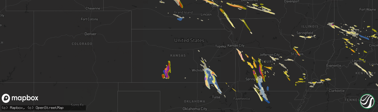
Hail Map in Kansas on July 17, 2023
The weather event in Kansas on July 17, 2023 includes Hail, Wind, and Tornado maps. 24 states and 1,163 cities were impacted and suffered possible damage. The total estimated number of properties impacted is 7,055.
Hail
Wind
Tornado
7,055
Estimated number of impacted properties by a 1.00" hail or larger4,488
Estimated number of impacted properties by a 1.75" hail or larger2,460
Estimated number of impacted properties by a 2.50" hail or largerStorm reports in Kansas
Kansas
| Date | Description |
|---|---|
| 07/17/20236:55 PM CDT | Six power poles snapped just east of the highway 160 and highway 34 intersection. |
| 07/17/20236:45 PM CDT | Tree damage at this location per social media report. |
| 07/17/20236:05 PM CDT | Mesonet station gw3433 dodge city. |
| 07/17/20236:04 PM CDT | Report from social media along with pictures. |
| 07/17/20236:04 PM CDT | Corrects previous non-tstm wnd gst report from 2 wsw mullinville. Mesonet station up372 2.3 w mullinville |
| 07/17/20235:55 PM CDT | Building structure damaged. |
| 07/17/20235:32 PM CDT | A local report indicates 2.50 inch wind near 2 ESE Windhorst |
| 07/17/20235:32 PM CDT | A local report indicates 3.00 inch wind near Windhorst |
| 07/17/20235:29 PM CDT | A local report indicates 1.50 inch wind near 2 ESE Windhorst |
| 07/17/20235:00 PM CDT | Multiple reports on social media of hail this size in kinsley. Pictures were included. |
| 07/17/20234:55 PM CDT | There were numerous reports and pictures shared on social media of a highly visible... Persistent... And fairly tall condensation funnel. There is a video on social med |
| 07/17/20234:51 PM CDT | Report from social media along with pictures. |
| 07/17/20234:44 PM CDT | A local report indicates 2.00 inch wind near Kinsley |
| 07/17/20234:42 PM CDT | A local report indicates 1.75 inch wind near Kinsley |
| 07/17/20234:30 PM CDT | A local report indicates 1.50 inch wind near Kinsley |
| 07/17/20234:30 PM CDT | Multiple reports from kinsley with hail this size on social media. Pictures were included. |
| 07/17/20233:45 PM CDT | A local report indicates 1.00 inch wind near 1 NNW Sanford |
| 07/17/20232:00 PM CDT | Picture of quarter sized hail. Delayed report. Time estimated by radar. |
| 07/17/20232:00 PM CDT | Delayed report. Time estimated from radar and surrounding reports. |
| 07/17/20231:53 PM CDT | Nickel to quarter sized hail fell briefly near peru. |
| 07/17/20231:22 PM CDT | Nickel to quarter sized near elk falls. Delayed report. Time estimated by radar. |
| 07/17/20231:08 PM CDT | Pictures on social media show golf ball sized hail near howard. Relayed by em. Delayed report. Time estimated by radar. |
| 07/17/20231:07 PM CDT | Picture of at least 2-inch hail on the outskirts of howard. Delayed report. Time estimated by radar. |
| 07/17/20231:07 PM CDT | Delayed report. Time estimated from radar and surrounding reports. |
| 07/17/202311:46 AM CDT | Wind driven hail damage to siding of a house. Windows also blown out. Most of dexter appears to have this damage. Time estimated by radar. |
| 07/17/202311:45 AM CDT | 6-inch diameter tree branches down. Delayed report. Time estimated by radar. |
| 07/17/202311:44 AM CDT | Via social media. |
| 07/17/202311:43 AM CDT | Via social media. |
| 07/17/202311:24 AM CDT | A local report indicates 1.00 inch wind near 1 ENE Burden |
| 07/17/202311:12 AM CDT | Structural damage to a potentially previously compromised building. Portion of a wall collapsed. Delayed report. Time estimated by radar. |
| 07/17/202311:09 AM CDT | Picture on social media of at least a 1-foot diameter tree branch snapped. Delayed report. Time estimated by radar. |
| 07/17/202311:07 AM CDT | 55 to 60 mph winds. Dust getting blown. |
| 07/17/202311:05 AM CDT | Measured from a mesonet. |
| 07/17/202310:55 AM CDT | K5eur. |
| 07/17/202310:53 AM CDT | Trees uprooted in piedmont along us 400. Delayed report. Time estimated by radar. |
| 07/17/202310:49 AM CDT | Via social media. |
| 07/17/202310:48 AM CDT | Dime to quarter sized hail. Via social media. |
| 07/17/202310:17 AM CDT | Nickel to quarter size hail at 40th and highway 77. |
| 07/17/202310:17 AM CDT | Highway signs ripped off their posts. 3-foot diameter tree downed. Delayed report. Time estimated by radar. |
| 07/16/20238:06 PM CDT | Reports of 3 inch tree limbs broken; power poles broken. |
All States Impacted by Hail Map on July 17, 2023
Cities Impacted by Hail Map on July 17, 2023
- Eddyville, IA
- Oskaloosa, IA
- Leigh, NE
- Clarkson, NE
- Cedar, IA
- Kirkville, IA
- Ottumwa, IA
- Fremont, IA
- Hedrick, IA
- Batavia, IA
- Howells, NE
- Schuyler, NE
- Dodge, NE
- Rogers, NE
- Scribner, NE
- North Bend, NE
- Fairfield, IA
- Eagleville, MO
- Hatfield, MO
- Ridgeway, MO
- Bethany, MO
- Fremont, NE
- Nickerson, NE
- Arlington, NE
- Hooper, NE
- Ames, NE
- Kennard, NE
- Blair, NE
- Valley, NE
- Washington, NE
- Bennington, NE
- Omaha, NE
- Carter Lake, IA
- Council Bluffs, IA
- Crescent, IA
- Gilman City, MO
- Trenton, MO
- Chillicothe, MO
- Jamesport, MO
- Chula, MO
- Knoxville, IA
- Milo, IA
- Pleasantville, IA
- Melcher Dallas, IA
- Lacona, IA
- Ackworth, IA
- Harvey, IA
- Tracy, IA
- Leighton, IA
- Pella, IA
- New Sharon, IA
- Chariton, IA
- Humeston, IA
- Williamson, IA
- Walnut, IA
- Atlantic, IA
- Lewis, IA
- Massena, IA
- Cumberland, IA
- Wiota, IA
- Bridgewater, IA
- Fontanelle, IA
- Greenfield, IA
- Orient, IA
- Glenwood, IA
- Silver City, IA
- Hastings, IA
- Imogene, IA
- Emerson, IA
- Essex, IA
- Malvern, IA
- Randolph, IA
- Shenandoah, IA
- Griswold, IA
- Elliott, IA
- Henderson, IA
- Red Oak, IA
- Centerville, MO
- Black, MO
- Braddyville, IA
- Blanchard, IA
- Elmo, MO
- Coin, IA
- Clearmont, MO
- College Springs, IA
- Clarinda, IA
- Burlington Junction, MO
- Skidmore, MO
- Maryville, MO
- Macksburg, IA
- Winterset, IA
- Osceola, IA
- Murray, IA
- Lorimor, IA
- Creston, IA
- Afton, IA
- Truro, IA
- Peru, IA
- Bunker, MO
- Lesterville, MO
- Barnard, MO
- Bolckow, MO
- Guilford, MO
- Florence, KS
- Burns, KS
- Leon, KS
- Ellington, MO
- Redford, MO
- Atlanta, KS
- Latham, KS
- Piedmont, MO
- El Dorado, KS
- Cambridge, KS
- Burden, KS
- Rosalia, KS
- Beaumont, KS
- Piedmont, KS
- Moline, KS
- Howard, KS
- Grenola, KS
- Mill Spring, MO
- Elk Falls, KS
- Elk City, KS
- Longton, KS
- Dexter, KS
- Cedar Vale, KS
- Winfield, KS
- Sedan, KS
- Peru, KS
- Niotaze, KS
- Maple City, KS
- Shidler, OK
- Newkirk, OK
- Chautauqua, KS
- Copan, OK
- Pawhuska, OK
- Havana, KS
- Dewey, OK
- Caney, KS
- Burbank, OK
- Bartlesville, OK
- Fairfax, OK
- Ochelata, OK
- Ramona, OK
- Nowata, OK
- Talala, OK
- Oologah, OK
- Claremore, OK
- Cassoday, KS
- Wisner, NE
- Beemer, NE
- Marion, KS
- Steelville, MO
- New Athens, IL
- Portsmouth, IA
- Logan, IA
- Woodbine, IA
- Albia, IA
- Cuba, MO
- Missouri Valley, IA
- Modale, IA
- Cedar Bluffs, NE
- Bourbon, MO
- Leasburg, MO
- Eldon, IA
- Libertyville, IA
- Douds, IA
- Selma, IA
- Anita, IA
- Hancock, IA
- Russell, IA
- Belleview, MO
- Bixby, MO
- Hillsboro, KS
- Minden, IA
- Persia, IA
- Neola, IA
- Shelby, IA
- Mineola, IA
- Platte Center, NE
- Columbus, NE
- Raymondville, MO
- Licking, MO
- Houston, MO
- Cedar Point, KS
- Herman, NE
- Beacon, IA
- Severy, KS
- Marissa, IL
- Lenzburg, IL
- New Virginia, IA
- Hugo, CO
- Avoca, IA
- Indianola, IA
- Hamilton, IA
- Bussey, IA
- Lucas, IA
- Birmingham, IA
- Potosi, MO
- Lovilia, IA
- Melrose, IA
- Independence, KS
- Coffeyville, KS
- Norwalk, IA
- Prole, IA
- Shannon City, IA
- Westboro, MO
- Rea, MO
- Union Star, MO
- Agency, IA
- Stockport, IA
- Elkhorn, NE
- Peabody, KS
- Walton, KS
- Hope, KS
- Abilene, KS
- Whitewater, KS
- Eureka, KS
- Potwin, KS
- Augusta, KS
- Keosauqua, IA
- Hillsboro, IA
- Bonaparte, IA
- Floris, IA
- Blakesburg, IA
- Bloomfield, IA
- Liberty Center, IA
- Saint Charles, IA
- Columbia, IA
- Chillicothe, IA
- University Park, IA
- Boss, MO
- Newton, KS
- Coulterville, IL
- Gypsum, KS
- Oakland, IA
- Cole Camp, MO
- Versailles, MO
- Stover, MO
- Lebanon, MO
- Osceola, MO
- Quincy, MO
- Weaubleau, MO
- Wheatland, MO
- Portage Des Sioux, MO
- Saint Charles, MO
- Florissant, MO
- Hazelwood, MO
- Saint Louis, MO
- Granite City, IL
- Venice, IL
- Madison, IL
- East Saint Louis, IL
- Lovejoy, IL
- Belleville, IL
- Stoutland, MO
- Richland, MO
- Waynesville, MO
- Saint Robert, MO
- Half Way, MO
- Bolivar, MO
- Polk, MO
- Buffalo, MO
- Rozel, KS
- Larned, KS
- Potomac, IL
- Danville, IL
- Bismarck, IL
- Covington, IN
- State Line, IN
- Pompano Beach, FL
- Coral Springs, FL
- Williamsport, IN
- Veedersburg, IN
- Hillsboro, IN
- Kinsley, KS
- Garfield, KS
- Lewis, KS
- Fair Grove, MO
- Pleasant Hope, MO
- Flemington, MO
- Strafford, MO
- Springfield, MO
- Rogersville, MO
- Marshfield, MO
- Fordland, MO
- Sparta, MO
- Bruner, MO
- Duke, MO
- Worden, IL
- Livingston, IL
- Seymour, MO
- Eureka, MO
- Fairmount, IL
- Sorento, IL
- Shelbyville, IL
- Catawissa, MO
- Hartville, MO
- Longview, IL
- Findlay, IL
- East Alton, IL
- Saint Clair, MO
- Pacific, MO
- Mountain Grove, MO
- Villa Grove, IL
- Saint James, MO
- Robertsville, MO
- Falcon, MO
- Witt, IL
- Oconee, IL
- Ballwin, MO
- Tower Hill, IL
- Lonedell, MO
- Staunton, IL
- Roby, MO
- Valley Park, MO
- Pana, IL
- Irving, IL
- Arcola, IL
- Taylor Springs, IL
- Hillsboro, IL
- Alhambra, IL
- Tuscola, IL
- Plato, MO
- Mansfield, MO
- Edwardsville, IL
- Walshville, IL
- High Ridge, MO
- Mount Olive, IL
- Sullivan, MO
- Homer, IL
- Lynchburg, MO
- South Roxana, IL
- Rolla, MO
- Roxana, IL
- Broadlands, IL
- Hartford, IL
- Grovespring, MO
- Newburg, MO
- Nokomis, IL
- Sullivan, IL
- Fenton, MO
- Edgar Springs, MO
- Cook Sta, MO
- Arthur, IL
- New Douglas, IL
- Rosamond, IL
- Philo, IL
- Ohlman, IL
- Lovington, IL
- Bethalto, IL
- Fithian, IL
- Atwood, IL
- Sidney, IL
- Union, MO
- Litchfield, IL
- Wood River, IL
- Pesotum, IL
- Tolono, IL
- Bethany, IL
- Moro, IL
- Butler, IL
- Assumption, IL
- Oakwood, IL
- Wildwood, MO
- Arcadia, IN
- Atlanta, IN
- Cicero, IN
- Noblesville, IN
- Westfield, IN
- Sheridan, IN
- Whitestown, IN
- Zionsville, IN
- Carmel, IN
- North Salem, IN
- Danville, IN
- Lizton, IN
- Pittsboro, IN
- Offerle, KS
- Oldfield, MO
- Ava, MO
- Garrison, MO
- Bradleyville, MO
- Chadwick, MO
- Greensburg, KS
- Thornfield, MO
- Theodosia, MO
- Rueter, MO
- Protem, MO
- Gainesville, MO
- Zanoni, MO
- Dora, MO
- Tecumseh, MO
- Caulfield, MO
- Bucklin, KS
- Avon, IN
- Indianapolis, IN
- Spearville, KS
- Ford, KS
- Mullinville, KS
- Pontiac, MO
- Peel, AR
- Isabella, MO
- Oakland, AR
- Yellville, AR
- Flippin, AR
- Bull Shoals, AR
- Mountain Home, AR
- Lakeview, AR
- Gassville, AR
- Cotter, AR
- Poplar Bluff, MO
- Fisk, MO
- Puxico, MO
- Brownsburg, IN
- Beech Grove, IN
- Raymore, MO
- Farmland, IN
- Winchester, IN
- Parker City, IN
- Pleasant Hill, MO
- Gravois Mills, MO
- Sunrise Beach, MO
- Camdenton, MO
- Climax Springs, MO
- Edwards, MO
- Roach, MO
- Harrisonville, MO
- Macks Creek, MO
- Eldridge, MO
- Tunas, MO
- Sturdivant, MO
- Zalma, MO
- Plainfield, IN
- Morristown, IN
- Shelbyville, IN
- Advance, MO
- Manilla, IN
- Homer, IN
- Rushville, IN
- Arlington, IN
- Bell City, MO
- Oran, MO
- Garden City, MO
- Liberty, IN
- College Corner, OH
- West College Corner, IN
- Camden, OH
- Harriet, AR
- Big Flat, AR
- Hollansburg, OH
- Fountain City, IN
- New Paris, OH
- New Madison, OH
- Eldorado, OH
- Arcanum, OH
- Minneola, KS
- Smithton, MO
- Sedalia, MO
- Edna, KS
- Bluejacket, OK
- Welch, OK
- Romney, IN
- Winchester, IL
- Godfrey, IL
- Dow, IL
- Elsah, IL
- Grafton, IL
- Lebanon, IN
- Thorntown, IN
- Collinsville, OK
- Rockville, IN
- Mora, MO
- Lowry City, MO
- Pittsburg, MO
- Hermitage, MO
- Fort Leonard Wood, MO
- Alton, IL
- Kaiser, MO
- Brumley, MO
- Tuscumbia, MO
- Ulman, MO
- Moweaqua, IL
- Dalton City, IL
- Cross Timbers, MO
- Warsaw, MO
- Laquey, MO
- Devils Elbow, MO
- Dixon, MO
- Palestine, WV
- Wappapello, MO
- Gillette, WY
- Winifrede, WV
- Eskdale, WV
- Hernshaw, WV
- Amesville, OH
- Athens, OH
- Patagonia, AZ
- Waynetown, IN
- New Market, IN
- Crawfordsville, IN
- Ladoga, IN
- New Ross, IN
- Eldon, MO
- Niangua, MO
- Bland, MO
- Owensville, MO
- Waycross, GA
- Jamestown, IN
- Belle, MO
- Clarksburg, OH
- Rosebud, MO
- Gerald, MO
- Brighton, MO
- Delaware, OK
- McGee, MO
- Charleston, WV
- Beulah, MO
- Vienna, MO
- Jefferson City, MO
- Linn, MO
- Westphalia, MO
- Freeburg, MO
- Koeltztown, MO
- Colfax, IN
- Clarks Hill, IN
- Armstrong, IL
- Frankfort, OH
- Washington Court House, OH
- Gainesville, FL
- Elkview, WV
- Tilton, IL
- Ogden, IL
- Rossville, IL
- Gifford, IL
- Penfield, IL
- Alvin, IL
- Henning, IL
- Collison, IL
- Fall River, KS
- Havre, MT
- Millstadt, IL
- Miami, WV
- Drybranch, WV
- Oberlin, LA
- Reeves, LA
- Kinder, LA
- Dry Creek, LA
- Afton, OK
- South West City, MO
- Fairland, OK
- Jay, OK
- Grove, OK
- Gravette, AR
- Sulphur Springs, AR
- Ragley, LA
- Linn Creek, MO
- Martinsville, MO
- Grant City, MO
- Crocker, MO
- Salem, MO
- Fairview Heights, IL
- Montreal, MO
- Singer, LA
- Taylorville, IL
- Osage Beach, MO
- Squires, MO
- Caseyville, IL
- Upper Tract, WV
- Petersburg, WV
- Jerome, MO
- Vinton, OH
- Modoc, IN
- Losantville, IN
- Chouteau, OK
- Pryor, OK
- Needham, AL
- Owasso, OK
- Wagoner, OK
- Inola, OK
- Catoosa, OK
- Wynona, OK
- Montezuma, IN
- Mecca, IN
- Lafayette, IN
- Frankfort, IN
- Bloomfield, MO
- Brixey, MO
- Nogales, AZ
- Sonoita, AZ
- Richmond Hill, GA
- Conway, MO
- South Charleston, WV
- Dunbar, WV
- Hartford City, IN
- Dunkirk, IN
- Deridder, LA
- Barnett, MO
- Dequincy, LA
- Vichy, MO
- Deepwater, MO
- Collins, MO
- Welch, WV
- Kimball, WV
- Williamsville, MO
- Linden, IN
- Ravenswood, WV
- Long Lane, MO
- Phillipsburg, MO
- Oakdale, LA
- Tipton, IN
- Carbon, IN
- Vail, AZ
- Portland, OH
- Saint Johns, FL
- Westpoint, IN
- Stonington, IL
- Collinsville, IL
- Marshall, AR
- Timbo, AR
- Onia, AR
- Fox, AR
- Leslie, AR
- Mountain View, AR
- Hardenville, MO
- Udall, MO
- Windyville, MO
- Marble Hill, MO
- Waverly, IL
- Auburn, IL
- Tucson, AZ
- Pawnee, IL
- Morrisonville, IL
- Kincaid, IL
- Palmer, IL
- Eaton, OH
- Oxford, OH
- Somerville, OH
- Mount Lemmon, AZ
- West Manchester, OH
- Lewisburg, OH
- Protection, KS
- Coldwater, KS
- Milroy, IN
- Laurel, IN
- Glenwood, IN
- Connersville, IN
- Metamora, IN
- Brookville, IN
- Quincy, IN
- Cloverdale, IN
- Gosport, IN
- Paragon, IN
- Hamilton, OH
- Peculiar, MO
- Spencer, IN
- Haviland, KS
- Creighton, MO
- Urich, MO
- Butler, MO
- Archie, MO
- Middletown, OH
- Franklin, OH
- Macomb, MO
- Rozet, WY
- Upton, WY
- Moorcroft, WY
- Branson, MO
- Dayton, OH
- Bellbrook, OH
- Waynesville, OH
- Spring Valley, OH
- Oregonia, OH
- Hollister, MO
- Omaha, AR
- Kirbyville, MO
- Lead Hill, AR
- Jackson, MO
- Oak Ridge, MO
- Cedarcreek, MO
- Cape Girardeau, MO
- Whitewater, MO
- Chaffee, MO
- Ashland, KS
- Norwood, MO
- Montrose, MO
- Appleton City, MO
- Harveysburg, OH
- Wilmington, OH
- Bloomington, IN
- Unionville, IN
- Chilhowee, MO
- Blairstown, MO
- Clinton, MO
- Leeton, MO
- Calhoun, MO
- Windsor, MO
- Lincoln, MO
- Harrison, AR
- Preston, MO
- Urbana, MO
- Everton, AR
- Valley Springs, AR
- Saint Joe, AR
- Wickliffe, KY
- Barlow, KY
- La Center, KY
- Kevil, KY
- Brookport, IL
- Smithland, KY
- Grand Rivers, KY
- Newcastle, WY
- Osage, WY
- Nashville, IN
- Gilbert, AR
- Harrison, NE
- Van Tassell, WY
- Lusk, WY
- Eddyville, KY
- Fredonia, KY
- Kuttawa, KY
- Marion, KY
- Tiline, KY
- Hill City, SD
- Edgemont, SD
- Custer, SD
- Hot Springs, SD
- Pringle, SD
- Buffalo Gap, SD
- Oral, SD
- Smithwick, SD
- Oelrichs, SD
- Springville, IN
- Bedford, IN
- Heltonville, IN
- Pine Ridge, SD
- Oglala, SD
- Medora, IN
- Campbellsburg, IN
- Vallonia, IN
- Norman, IN
- Scottsburg, IN
- Salem, IN
- Princeton, KY
- Greenville, MO
- Fairburn, SD
- Clinton, KY
- Brownstown, IN
- Elizabethtown, IN
- Columbus, IN
- Grammer, IN
- Newport, PA
- New Bloomfield, PA
- Garita, NM
- Maysville, KY
- Germantown, KY
- Freetown, IN
- Seymour, IN
- Farmersville, IL
- Chadron, NE
- Douglas, WY
- Henderson, NV
- Gonzales, LA
- Benton, KY
- Symsonia, KY
- Florence, MO
- New Straitsville, OH
- San Manuel, AZ
- Oracle, AZ
- Mammoth, AZ
- North Vernon, IN
- Commiskey, IN
- Olmsted, IL
- De Soto, MO
- Dittmer, MO
- Festus, MO
- Grubville, MO
- Luebbering, MO
- Hillsboro, MO
- Fillmore, IN
- Greencastle, IN
- New Palestine, IN
- Dawson Springs, KY
- West Paducah, KY
- Ledbetter, KY
- Bardwell, KY
- Boaz, KY
- Arlington, KY
- Charleston, MO
- Paducah, KY
- Calvert City, KY
- Cunningham, KY
- South Salem, OH
- Fortuna, MO
- Saint Augustine, FL
- Westport, IN
- Greensburg, IN
- Amado, AZ
- Trenton, OH
- Fishers, IN
- Milton, KY
- Madison, IN
- Kyle, SD
- Deputy, IN
- Patterson, MO
- Racine, OH
- Peridot, AZ
- Owaneco, IL
- Ellettsville, IN
- Lynn, IN
- Richmond, IN
- Crawford, NE
- Chestnutridge, MO
- Kissee Mills, MO
- Taneyville, MO
- Walnut Shade, MO
- Rockaway Beach, MO
- Forsyth, MO
- Russellville, MO
- Catlin, IL
- Perrysville, IN
- Westville, IL
- Martinsville, IN
- Poland, IN
- Coatesville, IN
- Fountaintown, IN
- Fifty Six, AR
- Kansas City, MO
- Scott City, MO
- Butlerville, IN
- East Lynne, MO
- Grandview, MO
- Lees Summit, MO
- Greenwood, MO
- Reeds Spring, MO
- Vevay, IN
- Carrollton, KY
- Paris Crossing, IN
- Solsberry, IN
- Letart, WV
- Mount Alto, WV
- Cottageville, WV
- Millwood, WV
- New Holland, OH
- Holden, MO
- Lake Charles, LA
- Nineveh, IN
- Trafalgar, IN
- East Prairie, MO
- New Madrid, MO
- Sulphur, LA
- Bridgeton, IN
- Rosedale, IN
- Brazil, IN
- Sells, AZ
- Divernon, IL
- Thayer, IL
- Virden, IL
- Clayton, IN
- Stilesville, IN
- Monrovia, IN
- Westlake, LA
- Vinton, LA
- Galion, OH
- Caledonia, OH
- Ashville, OH
- Circleville, OH
- Liverpool, PA
- Halifax, PA
- Millersburg, PA
- Sorrento, LA
- Saint Amant, LA
- Sabina, OH
- New Vienna, OH
- Clarksville, OH
- Brookville, OH
- West Alexandria, OH
- New Lebanon, OH
- Reelsville, IN
- Glendo, WY
- Huggins, MO
- Graff, MO
- Cabool, MO
- Freeburg, PA
- Selinsgrove, PA
- Middleburg, PA
- Mount Pleasant Mills, PA
- Lebanon, OH
- Springboro, OH
- Metropolis, IL
- Franklin, IN
- Freedom, IN
- Centerpoint, IN
- Stinesville, IN
- Morgantown, IN
- Scipio, IN
- Pulaski, IL
- Villa Ridge, IL
- Annapolis, MO
- Needham, IN
- Boggstown, IN
- Mount Olivet, KY
- Columbus, KY
- Waveland, IN
- Marshall, IN
- Spokane, MO
- Bloomfield, IN
- Flat Rock, IN
- Edinburgh, IN
- New Iberia, LA
- Brownsville, TN
- Ripley, WV
- Sandyville, WV
- West Columbia, WV
- Vulcan, MO
- Bainbridge, IN
- Russellville, IN
- Roachdale, IN
- Maurepas, LA
- Eugene, MO
- Henley, MO
- Greenfield, IN
- Mooresville, IN
- Vanduser, MO
- Brownwood, MO
- Sikeston, MO
- Glenallen, MO
- Gipsy, MO
- Mayslick, KY
- Seven Mile, OH
- Wilkinson, IN
- New Castle, IN
- Hagerstown, IN
- Chrisman, IL
- Bargersville, IN
- Middletown, IN
- Springport, IN
- Kingsville, MO
- Cedar Grove, TN
- Las Vegas, NM
- Waldron, IN
- Saint Paul, IN
- Story, AR
- Brooksville, KY
- Green Ridge, MO
- Milan, TN
- Medina, TN
- Camby, IN
- Cottonwood, AZ
- Cynthiana, KY
- Norfork, AR
- Drury, MO
- Gilbertsville, KY
- Fortville, IN
- Fairland, IN
- Pendleton, IN
- Ingalls, IN
- Greenwood, IN
- Whiteland, IN
- Knightstown, IN
- Shirley, IN
- Edinburg, IL
- Everett, PA
- Bedford, PA
- Attica, KS
- Jamestown, OH
- Xenia, OH
- Louisville, KY
- Finchville, KY
- Fisherville, KY
- Simpsonville, KY
- Shelbyville, KY
- Sellersburg, IN
- Jeffersonville, IN
- Prospect, KY
- Glenview, KY
- Pewee Valley, KY
- Crestwood, KY
- Bardstown, KY
- New Haven, KY
- Loretto, KY
- Springfield, KY
- Lebanon, KY
- Heartwell, NE
- Juniata, NE
- Kenesaw, NE
- Hastings, NE
- Holstein, NE
- Roseland, NE
- Ayr, NE
- Parksville, KY
- Gravel Switch, KY
- Brighton, IL
- Richland, MT
- Opheim, MT
- Stapleton, NE
- Wood, SD
- Wanblee, SD
- Duryea, PA
- Pittston, PA
- Wyoming, PA
- Clarks Summit, PA
- White River, SD
- Humboldt, TN
- Parmelee, SD
- Mission, SD
- Saint Francis, SD
- Boston, KY
- Elm Creek, NE
- Nicholasville, KY
- Long Valley, SD
- Kadoka, SD
- Croton, OH
- Johnstown, OH
- Trumbull, NE
- Harvard, NE
- Floyds Knobs, IN
- Pekin, IN
- Borden, IN
- Palmyra, IN
- Fredericksburg, IN
- Brady, NE
- Bedford, KY
- Worthville, KY
- Turners Station, KY
- Sanders, KY
- Norris, SD
- Sutton, NE
- Crothersville, IN
- Lexington, IN
- Austin, IN
- Elizabeth, IN
- Shepherdsville, KY
- Lebanon Junction, KY
- West Point, KY
- Anselmo, NE
- Maricopa, AZ
- Whitewater, MT
- Merna, NE
- Callaway, NE
- Arnold, NE
- Broken Bow, NE
- Versailles, KY
- Kearney, NE
- Shelton, NE
- Wood River, NE
- Gibbon, NE
- Kinmundy, IL
- Amherst, NE
- Riverdale, NE
- Salvisa, KY
- Laconia, IN
- Tunnelton, IN
- Orleans, IN
- Mitchell, IN
- Comfort, WV
- Cabin Creek, WV
- Point Pleasant, WV
- New Haven, WV
- Mason, WV
- Morrow, OH
- Central City, NE
- Wilber, NE
- Chillicothe, OH
- Friend, NE
- Harrodsburg, KY
- Lawrenceburg, KY
- Wilmore, KY
- Clarksville, IN
- Campbellsburg, KY
- Owenton, KY
- New Liberty, KY
- Hanover, IN
- Oolitic, IN
- Alma, IL
- Taylorsville, KY
- New Albany, IN
- Perryville, KY
- Bradfordsville, KY
- Atkinson, NE
- Shawnee, OH
- Taylor, NE
- Burwell, NE
- Ord, NE
- Ericson, NE
- Scotia, NE
- Elyria, NE
- North Loup, NE
- Brewster, NE
- Greeley, NE
- Wolbach, NE
- Saint Paul, NE
- Elba, NE
- Lame Deer, MT
- Birney, MT
- Crow Agency, MT
- Hardin, MT
- Rogersville, TN
- Sargent, NE
- Rutledge, TN
- Jefferson City, TN
- New Market, TN
- Hulett, WY
- Rosebud, SD
- Winner, SD
- Springview, NE
- Valentine, NE
- Hustonville, KY
- Dandridge, TN
- Sevierville, TN
- Columbia, KY
- Aladdin, WY
- Alva, WY
- Ainsworth, NE
- Bassett, NE
- Ballantine, MT
- Johnstown, NE
- Wood Lake, NE
- Long Pine, NE
- Weston, WY
- Ashton, NE
- Williamsburg, KY
- Parkers Lake, KY
- Whitley City, KY
- Elk Horn, KY
- Liberty, KY
- Dunnville, KY
- Firth, NE
- Adams, NE
- Middleburg, KY
- New Hope, KY
- Busby, MT
- Burnside, KY
- Huntley, MT
- Waynesburg, KY
- Eubank, KY
- Kings Mountain, KY
- Douglas, NE
- Windsor, KY
- Knifley, KY
- Nancy, KY
- Somerset, KY
- Sparks, NE
- Talbott, TN
- White Pine, TN
- Powder Springs, TN
- Blaine, TN
- Washburn, TN
- Morrill, KS
- Hiawatha, KS
- Farwell, NE
- Otter, MT
- Kearney, MO
- Lawson, MO
- Edgerton, MO
- Fair Play, MO
- Lone Jack, MO
- Oak Grove, MO
- Sneedville, TN
- Liberty, MO
- Holt, MO
- Excelsior Springs, MO
- Purdum, NE


