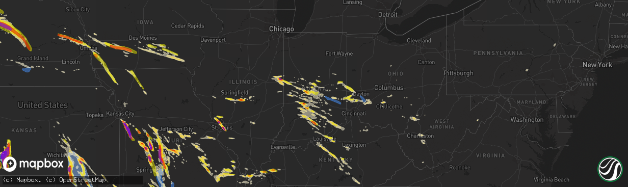
Hail Map on July 17, 2023
The weather event on July 17, 2023 includes Hail, Wind, and Tornado maps. 24 states and 1,163 cities were impacted and suffered possible damage. The total estimated number of properties impacted is 480,103.
Hail
Wind
Tornado
480,103
Estimated number of impacted properties by a 1.00" hail or larger107,710
Estimated number of impacted properties by a 1.75" hail or larger18,994
Estimated number of impacted properties by a 2.50" hail or largerStates Impacted by Hail Map on July 17, 2023
Storm reports
Indiana
| Date | Description |
|---|---|
| 07/17/20236:48 PM CDT | Late reports of thunderstorm winds downing at least two trees in east central morgan county. Time estimated by radar. |
| 07/17/20236:47 PM CDT | Late report of thunderstorm winds downing power lines and a fire at 2627 south county road 675 east. Time estimated by radar. |
| 07/17/20236:35 PM CDT | Late report of thunderstorm winds downing tree on power line and transformer on indiana route 44 at 235 west. Time estimated by radar. |
| 07/17/20236:05 PM CDT | Report from mping: 1-inch tree limbs broken; shingles blown off. |
| 07/17/20235:38 PM CDT | Near old national centre 502 n new jersey st... Indianapolis in. |
| 07/17/20235:35 PM CDT | Located at randolph co fairgrounds 1885 us hwy 27 winchester... In. |
| 07/17/20235:28 PM CDT | Late report of thunderstorm winds downing tree onto indiana route 38 at 2277 west. Time estimated by radar. |
| 07/17/20235:24 PM CDT | Approximate location. |
| 07/17/20235:23 PM CDT | Approximate location. |
| 07/17/20235:19 PM CDT | Report from mping: hen egg |
| 07/17/20235:17 PM CDT | A local report indicates 1.00 inch wind near 2 W Speedway |
| 07/17/20235:15 PM CDT | Time estimated from radar. |
| 07/17/20235:15 PM CDT | Thunderstorm winds estimated to 60-65 mph downed a few large trees. Small hail also occurred. |
| 07/17/20235:15 PM CDT | A local report indicates 1.25 inch wind near 1 N Danville |
| 07/17/20235:10 PM CDT | Corrects previous hail report from 1 ne danville. Cocorahs observer in-hs-43 reports 1 inch hail and shredded leaves. Time of event corrected. |
| 07/17/20235:10 PM CDT | Late report of thunderstorm winds downing tree onto indiana route 32 at 9600 west. Time estimated by radar. |
| 07/17/20235:05 PM CDT | Time estimated from radar. |
| 07/17/20234:58 PM CDT | Report from mping: golf ball |
| 07/17/20234:58 PM CDT | A local report indicates 1.00 inch wind near 1 SW Westfield |
| 07/17/20234:50 PM CDT | Located at state road 32 and ditch road. Accompanied by hail up to the size of coin quarters and heavy rain. |
| 07/17/20234:50 PM CDT | At state road 32 and ditch road. Started with pea size and grew to quarter coin size. Heavy rain and estimated winds 55 to 60 mph. |
| 07/17/20234:43 PM CDT | Hail ongoing in arcadia with hailstones ranging from dime sized to just larger than quarters. |
| 07/17/20233:56 PM CDT | Late report of thunderstorm winds downing power lines at 700 west and 380 south. Time estimated by radar. |
| 07/17/20233:39 PM CDT | A local report indicates 1.00 inch wind near Covington |
| 07/17/20233:32 PM CDT | Corrects previous hail report from covington. Time estimated from radar. |
| 07/16/202311:32 PM CDT | A local report indicates 1.25 inch wind near 1 ENE Mckinley |
| 07/16/202311:20 PM CDT | Late report of thunderstorm winds downing and uprooting numerous trees in southwestern jackson county. Widespread small hail. Time estimated by radar. |
| 07/16/202310:15 PM CDT | A local report indicates 1.00 inch wind near 2 S Wirt |
| 07/16/202310:15 PM CDT | Tree down over north eagle hollow road. |
| 07/16/20239:45 PM CDT | Tree down partially covering sr-350... 1 mile east of sr-129. |
| 07/16/20238:54 PM CDT | Report from mping: 3-inch tree limbs broken; power poles broken. |
| 07/16/20238:45 PM CDT | Late report of thunderstorm winds downing 3 trees across southern brown county. Time estimated by radar. |
| 07/16/20238:33 PM CDT | Late report of thunderstorm winds downing tree on little flock road. Time estimated by radar. |
| 07/16/20238:00 PM CDT | Late report of thunderstorm winds downing a few trees across northern monroe county. Time estimated by radar. |
| 07/16/20237:50 PM CDT | Late report of thunderstorm winds downing tree onto bain road. Time estimated by radar. |
| 07/16/20237:30 PM CDT | Late report of thunderstorm winds downing tree at 240 east pike street. |
| 07/16/20237:10 PM CDT | Cocorahs observer in-hs-43 reports 1 inch hail and shredded leaves. |
| 07/16/20237:05 PM CDT | Golf ball hail at west base line and waggoner roads. Time estimated by radar. |
| 07/16/20237:01 PM CDT | A few trees were downed in the brookville area. |
Illinois
| Date | Description |
|---|---|
| 07/17/20236:36 PM CDT | Relayed from broadcast media. |
| 07/17/20236:32 PM CDT | A local report indicates 1.00 inch wind near 1 W Auburn |
| 07/17/20233:36 PM CDT | Reported at memorial hospital. |
| 07/17/20233:36 PM CDT | A local report indicates 1.00 inch wind near 1 WSW Belleville |
| 07/17/20233:33 PM CDT | A local report indicates 2.00 inch wind near 3 NW Belleville |
| 07/17/20233:32 PM CDT | Hail lasted for 12 minutes. |
| 07/17/20233:29 PM CDT | By lady of the snows shrine on highway 15. |
| 07/17/20233:29 PM CDT | Hail up to tennis ball size. Also... Several cars with windows broken in the area where the hail fell. |
| 07/17/20233:28 PM CDT | A local report indicates 1.00 inch wind near Caseyville |
| 07/17/20233:26 PM CDT | A local report indicates 1.25 inch wind near 2 WNW Belleville |
| 07/17/20233:20 PM CDT | A local report indicates 1.00 inch wind near 1 ENE Granite City |
| 07/17/20233:12 PM CDT | A local report indicates 1.25 inch wind near Madison |
| 07/17/20233:12 PM CDT | Report from mping: half dollar |
| 07/17/20233:10 PM CDT | Relayed from broadcast media. |
| 07/17/20233:07 PM CDT | *** 2 inj *** a large tree was uprooted onto a house on logan street. Two people inside the home were injured and taken to a nearby hospital. |
| 07/17/20233:03 PM CDT | Relayed via broadcast media. |
| 07/17/20233:02 PM CDT | Large tree snapped off. It fell onto a power line taking the line down. Via picture on twitter. |
| 07/17/20233:00 PM CDT | A local report indicates 1.75 inch wind near Bismarck |
| 07/17/20232:38 PM CDT | Mix of pea... Dime... And quarter sized hail. |
| 07/16/20237:41 PM CDT | Trees and large tree limbs down in anna-jonesboro. |
| 07/16/20237:16 PM CDT | A local report indicates 1.75 inch wind near 1 ESE Taylorville Airpo |
| 07/16/20237:13 PM CDT | A local report indicates 1.50 inch wind near 1 NW Taylorville |
| 07/16/20237:10 PM CDT | A local report indicates 1.50 inch wind near 1 WSW Taylorville |
| 07/16/20237:09 PM CDT | Report from mping: ping pong ball |
| 07/16/20237:07 PM CDT | Report from mping: ping pong ball |
| 07/16/20237:07 PM CDT | Relayed via social media. |
Kansas
| Date | Description |
|---|---|
| 07/17/20236:55 PM CDT | Six power poles snapped just east of the highway 160 and highway 34 intersection. |
| 07/17/20236:45 PM CDT | Tree damage at this location per social media report. |
| 07/17/20236:05 PM CDT | Mesonet station gw3433 dodge city. |
| 07/17/20236:04 PM CDT | Report from social media along with pictures. |
| 07/17/20236:04 PM CDT | Corrects previous non-tstm wnd gst report from 2 wsw mullinville. Mesonet station up372 2.3 w mullinville |
| 07/17/20235:55 PM CDT | Building structure damaged. |
| 07/17/20235:32 PM CDT | A local report indicates 2.50 inch wind near 2 ESE Windhorst |
| 07/17/20235:32 PM CDT | A local report indicates 3.00 inch wind near Windhorst |
| 07/17/20235:29 PM CDT | A local report indicates 1.50 inch wind near 2 ESE Windhorst |
| 07/17/20235:00 PM CDT | Multiple reports on social media of hail this size in kinsley. Pictures were included. |
| 07/17/20234:55 PM CDT | There were numerous reports and pictures shared on social media of a highly visible... Persistent... And fairly tall condensation funnel. There is a video on social med |
| 07/17/20234:51 PM CDT | Report from social media along with pictures. |
| 07/17/20234:44 PM CDT | A local report indicates 2.00 inch wind near Kinsley |
| 07/17/20234:42 PM CDT | A local report indicates 1.75 inch wind near Kinsley |
| 07/17/20234:30 PM CDT | A local report indicates 1.50 inch wind near Kinsley |
| 07/17/20234:30 PM CDT | Multiple reports from kinsley with hail this size on social media. Pictures were included. |
| 07/17/20233:45 PM CDT | A local report indicates 1.00 inch wind near 1 NNW Sanford |
| 07/17/20232:00 PM CDT | Picture of quarter sized hail. Delayed report. Time estimated by radar. |
| 07/17/20232:00 PM CDT | Delayed report. Time estimated from radar and surrounding reports. |
| 07/17/20231:53 PM CDT | Nickel to quarter sized hail fell briefly near peru. |
| 07/17/20231:22 PM CDT | Nickel to quarter sized near elk falls. Delayed report. Time estimated by radar. |
| 07/17/20231:08 PM CDT | Pictures on social media show golf ball sized hail near howard. Relayed by em. Delayed report. Time estimated by radar. |
| 07/17/20231:07 PM CDT | Picture of at least 2-inch hail on the outskirts of howard. Delayed report. Time estimated by radar. |
| 07/17/20231:07 PM CDT | Delayed report. Time estimated from radar and surrounding reports. |
| 07/17/202311:46 AM CDT | Wind driven hail damage to siding of a house. Windows also blown out. Most of dexter appears to have this damage. Time estimated by radar. |
| 07/17/202311:45 AM CDT | 6-inch diameter tree branches down. Delayed report. Time estimated by radar. |
| 07/17/202311:44 AM CDT | Via social media. |
| 07/17/202311:43 AM CDT | Via social media. |
| 07/17/202311:24 AM CDT | A local report indicates 1.00 inch wind near 1 ENE Burden |
| 07/17/202311:12 AM CDT | Structural damage to a potentially previously compromised building. Portion of a wall collapsed. Delayed report. Time estimated by radar. |
| 07/17/202311:09 AM CDT | Picture on social media of at least a 1-foot diameter tree branch snapped. Delayed report. Time estimated by radar. |
| 07/17/202311:07 AM CDT | 55 to 60 mph winds. Dust getting blown. |
| 07/17/202311:05 AM CDT | Measured from a mesonet. |
| 07/17/202310:55 AM CDT | K5eur. |
| 07/17/202310:53 AM CDT | Trees uprooted in piedmont along us 400. Delayed report. Time estimated by radar. |
| 07/17/202310:49 AM CDT | Via social media. |
| 07/17/202310:48 AM CDT | Dime to quarter sized hail. Via social media. |
| 07/17/202310:17 AM CDT | Nickel to quarter size hail at 40th and highway 77. |
| 07/17/202310:17 AM CDT | Highway signs ripped off their posts. 3-foot diameter tree downed. Delayed report. Time estimated by radar. |
| 07/16/20238:06 PM CDT | Reports of 3 inch tree limbs broken; power poles broken. |
Florida
| Date | Description |
|---|---|
| 07/17/20236:14 PM CDT | Report of trees down from thunderstorm. |
| 07/17/20236:14 PM CDT | Report of trees down caused by thunderstorm. |
| 07/17/20236:13 PM CDT | Trees down. |
| 07/17/20236:10 PM CDT | Report of trees down caused by thunderstorm. |
| 07/17/20235:20 PM CDT | St. Johns county fire/rescue reports numerous trees and powerlines down across the northwestern and western portions of the county. Time of damage based on radar data. |
| 07/17/20233:05 PM CDT | Trained spotter reported nickel to quarter size hail in parkland florida along sr-7. |
| 07/17/20231:23 PM CDT | Fallen trees or limbs resulted in a power outage along doctor mlk jr blvd. |
| 07/17/20231:23 PM CDT | Fallen trees or limbs resulted in a power outage along highway 98 near red oak ln. |
| 07/17/20231:23 PM CDT | Fallen trees or limbs resulted in a power outage along river plantation road. |
Utah
| Date | Description |
|---|---|
| 07/17/20235:20 PM CDT | Strong crosswinds overturn multiple semi trucks on i-15 at mp 163. |
| 07/17/20235:00 PM CDT | Mesonet station utcir i-15 at mp 169. |
| 07/17/20234:55 PM CDT | A local report indicates 71 MPH wind near 1 N Milford |
| 07/16/20239:40 PM CDT | Mesonet station pc291 scipio summit. |
| 07/16/20239:40 PM CDT | Mesonet station utsci scipio summit. |
| 07/16/20237:40 PM CDT | Mesonet station pc349 nephi west. |
| 07/16/20237:30 PM CDT | Mesonet station dpg21 simpson spring. |
Iowa
| Date | Description |
|---|---|
| 07/17/20239:25 AM CDT | Via social media. |
| 07/17/20238:40 AM CDT | A local report indicates 1.25 inch wind near Malvern |
| 07/17/20238:38 AM CDT | A local report indicates 1.00 inch wind near Malvern |
| 07/17/20238:35 AM CDT | A local report indicates 1.50 inch wind near Malvern |
| 07/17/20238:33 AM CDT | A local report indicates 1.00 inch wind near 1 N Oskaloosa |
| 07/17/20238:32 AM CDT | A local report indicates 1.00 inch wind near 1 N Oskaloosa |
| 07/17/20237:53 AM CDT | Relayed via knia/krls radio. |
Nebraska
| Date | Description |
|---|---|
| 07/17/20237:55 AM CDT | A local report indicates 1.75 inch wind near Arlington |
| 07/17/20237:50 AM CDT | Near airport. |
| 07/17/20237:49 AM CDT | A local report indicates 1.75 inch wind near 2 SW Nickerson |
| 07/17/20237:03 AM CDT | A local report indicates 1.75 inch wind near Leigh |
| 07/17/20236:55 AM CDT | Nickle to quarter size hail. |
| 07/17/20236:15 AM CDT | 1.00 to 1.25 size hail; three rounds of hail peas to 1.25 inch. |
| 07/17/20235:08 AM CDT | 2.25 inch hail lasting approximately 3 to 5 minutes. |
| 07/17/20232:17 AM CDT | A local report indicates 60 MPH wind near Hastings Airport |
Colorado
| Date | Description |
|---|---|
| 07/17/20235:30 PM CDT | Awos station kank salida airport. Caused from high based shower. |
Arizona
| Date | Description |
|---|---|
| 07/17/20236:50 PM CDT | Corrects previous non-tstm wnd dmg report from 8 n tucson. Trees and power poles down and roof damage. Time estimated from radar. |
| 07/17/20236:35 PM CDT | Spotter 873 reported 67.5 mph gusts on their home weather station 1200 n sunspot place. |
| 07/17/20236:34 PM CDT | Asos station kdma davis monthan afb. |
| 07/17/20236:29 PM CDT | Chris called in 1 inch hail on speedway and pantano. You could hear the hail pelting the car of the caller. |
| 07/17/20235:30 PM CDT | Sasabe raws qsba3 buenos aires national wildlife refuge. |
| 07/16/20239:50 PM CDT | ***delayed report*** approximately a dozen power poles were reported down near barnes road and stanfield road. Timing estimated from radar. |
| 07/16/20237:55 PM CDT | Awos station kavq marana regional airport. |
| 07/16/20237:50 PM CDT | Trees uprooted on sunrise and swan. Reported by twitter user @connormcgilltv at approximately 5:50 pm mst. |
| 07/16/20237:02 PM CDT | Tree limbs down wetmore and stone. |
| 07/16/20237:00 PM CDT | Public report to tom says there was a wreck with power poles down on swan road north of river road. |
| 07/16/20237:00 PM CDT | Tree limbs broken and trees uprooted. Reports of shingles blown off and a power outage for much of page. |
| 07/16/20237:00 PM CDT | Video of brief landspout tornado. Time estimated. |
Nevada
| Date | Description |
|---|---|
| 07/17/20236:47 PM CDT | Nv dot sensor apxnv at interstate 15 southbound at highway 93 measured a wind gust of 58 mph from a nearby thunderstorm. |
| 07/17/20235:30 PM CDT | Mesonet station dnep2 3.1 e shoshone |
| 07/16/20238:50 PM CDT | Several sites in henderson by water street have observed between 58 and 64 mph wind gusts from a nearby thunderstorm. |
Pennsylvania
| Date | Description |
|---|---|
| 07/17/20236:22 PM CDT | Sporadic reports of trees on wires across northern dauphin county. |
| 07/17/20236:19 PM CDT | Trees and wires reported down in watts township. |
| 07/17/20236:10 PM CDT | Sporadic reports of trees and wires down in the vicinity of newport. |
| 07/16/20238:53 PM CDT | Multiple reports of trees and wires down in scranton. Time estimated from radar. |
| 07/16/20238:45 PM CDT | Wooden swingset/playground knocked over. |
| 07/16/20238:45 PM CDT | Multiple reports of trees uprooted in the old forge area. |
| 07/16/20238:42 PM CDT | Corrects previous tstm wnd dmg report from pittston. Tree and wires down at luzerne avenue and susquehanna avenue. Time estimated from radar. |
Virginia
| Date | Description |
|---|---|
| 07/17/20236:40 PM CDT | Numerous large tree branches downed by thunderstorm winds on mount tabor road in happy hollow area. |
| 07/17/20236:39 PM CDT | Tree downed by thunderstorm winds on chrisman mill road. |
| 07/17/20236:26 PM CDT | Two trees about ten inches in diameter downed by thunderstorm winds on placid lane. |
| 07/17/20236:26 PM CDT | Tree downed by thunderstorm winds... And landed on power line on the forest service road in pandapas pond. |
| 07/17/20236:24 PM CDT | Tree downed by thunderstorm winds on old maybrook road. |
| 07/17/20236:21 PM CDT | Tree downed by thunderstorm winds on eggleston road. |
| 07/17/20236:19 PM CDT | Tree downed by thunderstorm winds on sinking creek road. |
| 07/17/20236:19 PM CDT | Trees downed by thunderstorm winds on cascade drive. |
| 07/16/20238:02 PM CDT | 1-inch tree limbs broken; shingles blown off. |
Ohio
| Date | Description |
|---|---|
| 07/17/20236:56 PM CDT | A few trees were downed in the lewisburg area. |
| 07/17/20236:47 PM CDT | Multiple trees down along tanners run road and sr 124. Time estimated from radar. |
| 07/17/20236:46 PM CDT | Trained spotter measured 1 inch hail. |
| 07/17/20236:32 PM CDT | A few trees were downed between morning sun and college corner. |
| 07/17/20236:23 PM CDT | Trained spotter reports 1 inch hail near intersection of arnold st. And s main st. |
| 07/17/20234:35 PM CDT | Several tree limbs down. |
| 07/17/20232:34 PM CDT | Multiple reports of trees down in the amesville... Ohio area. |
| 07/16/202310:51 PM CDT | Tree down on the roadway. |
| 07/16/202310:51 PM CDT | Trees down... Blocking both lanes of county road 1. There are also trees resting along the power lines. Time estimated from radar. |
| 07/16/202310:50 PM CDT | Large tree down blocking both lanes of state route 650. Time estimated from radar. |
| 07/16/20239:50 PM CDT | 1 tree down near brandon in miller township. Time estimated by radar. |
| 07/16/20238:22 PM CDT | Large tree limb down - time estimated from radar. |
| 07/16/20238:13 PM CDT | Large tree down on anderson road. |
| 07/16/20238:00 PM CDT | 8 in diameter tree knocked down. Time est from radar. |
| 07/16/20237:58 PM CDT | Tree reported down on a house. Tree was reported as in a dying state before thunderstorms hit. Time estimated from radar. |
| 07/16/20237:45 PM CDT | Five trees down in washington twp. |
| 07/16/20237:38 PM CDT | Report of a roof partially torn off the rear side of a home. Roof is down to rafters. Time est from radar. |
| 07/16/20237:36 PM CDT | Roof damage to house on 7300 block of timber wolf drive. Photo verified. Time estimated from radar. |
| 07/16/20237:28 PM CDT | Large tree downed and fallen onto shed. Time estimated from radar. |
| 07/16/20237:19 PM CDT | Large tree down near shul road and route 122. |
| 07/16/20237:19 PM CDT | Large tree down near shul road and route 122. |
| 07/16/20237:15 PM CDT | Large tree down - time estimated from radar. |
Oklahoma
| Date | Description |
|---|---|
| 07/17/20232:44 PM CDT | A local report indicates 1.00 inch wind near 2 SE Bartlesville |
| 07/17/20232:42 PM CDT | A local report indicates 1.75 inch wind near 1 WNW Bartlesville |
| 07/17/20232:40 PM CDT | Chaser for broadcast media reported 1.5 hail in bartlesville. |
| 07/17/20232:35 PM CDT | Spotter in the oak park area north of the bartlesville airport reported nickel to quarter size hail... Beginning to cover the ground. |
| 07/17/20231:20 PM CDT | Carport blow into street and garage door bent in. Pictures relayed via social media. Time estimated from radar. |
| 07/17/202312:34 PM CDT | Quarter hail observed by storm chaser in shidler. Time estimated by radar. |
Kentucky
| Date | Description |
|---|---|
| 07/17/20233:44 AM CDT | A local report indicates 1.00 inch wind near Dunnville |
| 07/17/20233:36 AM CDT | A local report indicates 1.00 inch wind near 2 WNW Dunnville |
| 07/17/20232:32 AM CDT | A local report indicates 1.00 inch wind near 1 NE Nicholasville |
| 07/17/20231:15 AM CDT | A local report indicates 1.00 inch wind near Finchville |
| 07/17/20231:06 AM CDT | A local report indicates 1.00 inch wind near 4 SE Pewee Valley |
| 07/17/202312:09 AM CDT | A local report indicates 1.00 inch wind near Middletown |
| 07/17/202312:09 AM CDT | A local report indicates 1.50 inch wind near 2 ENE Middletown |
| 07/16/202310:25 PM CDT | Tree down on highway 55 - time estimated from radar. |
| 07/16/202310:23 PM CDT | Large tree blocking road - time estimated from radar. |
| 07/16/20239:30 PM CDT | A local report indicates 1.50 inch wind near 3 NNE Princeton |
| 07/16/20239:05 PM CDT | Tree down over the road at ky 293 and 1415. |
| 07/16/20238:07 PM CDT | Trees down. |
| 07/16/20238:02 PM CDT | Large tree down. |
| 07/16/20237:54 PM CDT | A local report indicates 1.50 inch wind near 2 N Blandville |
| 07/16/20237:36 PM CDT | Tree on a house in arlington. Numerous trees down on county road 1210 west of arlington. Trees... Fences down. |
Wyoming
| Date | Description |
|---|---|
| 07/17/20236:10 PM CDT | A local report indicates 3.00 inch wind near 8 N Dwtn Gillette |
| 07/17/20236:09 PM CDT | A local report indicates 59 MPH wind near 2 ESE Medicine Bow |
| 07/16/20239:00 PM CDT | Mping report |
| 07/16/20239:00 PM CDT | Quarter size hail lasting for about 5-7 minutes |
| 07/16/20238:59 PM CDT | Lots of hail coating the ground. |
| 07/16/20238:12 PM CDT | A local report indicates 1.25 inch wind near 8 WSW Upton |
| 07/16/20238:04 PM CDT | A local report indicates 78 MPH wind near 5 NW Arlington |
| 07/16/20237:58 PM CDT | A local report indicates 62 MPH wind near 5 NW Arlington |
| 07/16/20237:45 PM CDT | Wind driven hail broke a window. |
| 07/16/20237:45 PM CDT | Hail broke windows and damaged siding. |
| 07/16/20237:45 PM CDT | Wind driven hail broke a window. |
| 07/16/20237:42 PM CDT | A local report indicates 72 MPH wind near 2 ESE Elk Mountain |
| 07/16/20237:20 PM CDT | Estimated wind gust of 30 to 50 mph. |
| 07/16/20237:20 PM CDT | Photo of hail slightly larger than a quarter |
| 07/16/20237:20 PM CDT | A local report indicates 1.75 inch wind near 8 SE Dwtn Gillette |
| 07/16/20237:15 PM CDT | A local report indicates 1.50 inch wind near 3 S Dwtn Gillette |
West Virginia
| Date | Description |
|---|---|
| 07/17/20235:14 PM CDT | Report from mping: 1-inch tree limbs broken; shingles blown off. |
| 07/17/20234:58 PM CDT | A couple trees down near the 1200 block of south fork road. |
| 07/17/20233:15 PM CDT | Tree contact caused power outages. |
| 07/17/20232:45 PM CDT | Tree contact caused power outages. |
| 07/17/20232:36 PM CDT | Tree down in neighborhood. Wind estimated 40 to 50 mph. Also small hail. Time estimated from radar. |
| 07/17/20232:36 PM CDT | Tree down. Time estimated from outflow boundary on radar. No direct hit from thunderstorm. |
| 07/17/20232:22 PM CDT | Tree down. Time estimated from radar. |
| 07/16/202310:57 PM CDT | Trained spotter has measured 3.75 inches of rain so far in the last 6 hours. |
Arkansas
| Date | Description |
|---|---|
| 07/17/20236:40 PM CDT | Couple of trees blown down in mountain view. |
| 07/17/20235:52 PM CDT | Several trees blown down across the county. |
| 07/17/20233:15 PM CDT | Pics of damaged trees... Fence and a power pole down in springdale...time estimated by radar. |
South Dakota
| Date | Description |
|---|---|
| 07/17/20234:55 AM CDT | A local report indicates 1.00 inch wind near 2 N Rosebud |
| 07/16/202311:15 PM CDT | A local report indicates 59 MPH wind near Wasta |
| 07/16/202310:59 PM CDT | A local report indicates 60 MPH wind near 3 NW Wasta |
| 07/16/202310:53 PM CDT | Estimated 50 to 60 mph winds... Small branches down |
| 07/16/202310:36 PM CDT | A local report indicates 63 MPH wind near Rapid City Arpt |
| 07/16/202310:30 PM CDT | A local report indicates 2.50 inch wind near Oral |
| 07/16/202310:20 PM CDT | A local report indicates 2.50 inch wind near 9 W Smithwick |
| 07/16/202310:20 PM CDT | Mping report |
| 07/16/202310:17 PM CDT | A local report indicates 2.75 inch wind near 7 SSE Hot Springs |
| 07/16/202310:03 PM CDT | A local report indicates 2.50 inch wind near 1 W Hot Springs |
| 07/16/20239:58 PM CDT | A local report indicates 2.25 inch wind near 5 WNW Hot Springs |
| 07/16/20239:56 PM CDT | A local report indicates 1.75 inch wind near 5 W Hot Springs |
| 07/16/20239:54 PM CDT | A local report indicates 2.50 inch wind near 4 W Hot Springs |
| 07/16/20239:49 PM CDT | A local report indicates 66 MPH wind near 11 W Hot Springs |
| 07/16/20239:46 PM CDT | A local report indicates 1.25 inch wind near Argyle |
| 07/16/20239:15 PM CDT | Time estimated from radar. |
| 07/16/20239:12 PM CDT | A local report indicates 61 MPH wind near 10 W Jewel Cave |
Missouri
| Date | Description |
|---|---|
| 07/17/20236:50 PM CDT | A local report indicates 2.75 inch wind near 5 S Garden City |
| 07/17/20236:49 PM CDT | Large tree uprooted and fell onto a garage causing moderate roof damage. Also a car sustained damage from the fallen tree. Numerous tree limbs blown down as well. Via p |
| 07/17/20236:45 PM CDT | Report from mping: hen egg |
| 07/17/20236:40 PM CDT | A local report indicates 4.00 inch wind near 3 W Garden City |
| 07/17/20236:38 PM CDT | Went from pea to quarter size. |
| 07/17/20236:38 PM CDT | Numerous reports of softball sized hail in garden city. Also received photo of a 5 inch hail stone measured with tape measure. |
| 07/17/20236:35 PM CDT | Hail 7 miles west of eldridge cracked windshield. |
| 07/17/20236:28 PM CDT | A local report indicates 2.75 inch wind near 3 ESE Harrisonville |
| 07/17/20236:24 PM CDT | Photos of several 3 inch hailstone from east harrisonville. Time estimated from radar. |
| 07/17/20236:24 PM CDT | A local report indicates 4.00 inch wind near 1 ESE Harrisonville |
| 07/17/20236:24 PM CDT | Corrects previous tstm wnd dmg report from 2 nne oermann. Large tree limb snapped off and landed on township ln. |
| 07/17/20236:13 PM CDT | Large tree limb snapped off and landed on township ln. |
| 07/17/20236:10 PM CDT | A local report indicates 1.00 inch wind near 2 NNE Roach |
| 07/17/20236:06 PM CDT | Report from mping: quarter |
| 07/17/20236:06 PM CDT | A local report indicates 1.50 inch wind near 2 WNW Camdenton |
| 07/17/20236:06 PM CDT | Hail had fallen about 20 minutes prior and was still measuring around 3 inches. Time estimated from radar. |
| 07/17/20236:03 PM CDT | A local report indicates 3.00 inch wind near 3 SSW Lake Winnebago |
| 07/17/20235:59 PM CDT | A local report indicates 1.00 inch wind near Camdenton |
| 07/17/20235:58 PM CDT | Large tree snapped off and pulled down nearby power line. |
| 07/17/20235:57 PM CDT | A local report indicates 1.00 inch wind near 4 ESE Williamsville |
| 07/17/20235:47 PM CDT | A local report indicates 1.00 inch wind near 1 N Raymore |
| 07/17/20235:20 PM CDT | Delayed report. Several reports of trees and limbs down in both the thornfield and theodosia areas. |
| 07/17/20235:15 PM CDT | Via social media picture. |
| 07/17/20235:01 PM CDT | Report from mping: 3-inch tree limbs broken; power poles broken. |
| 07/17/20234:59 PM CDT | Tree limbs up to 3 inches in diameter blown down. Pea size hail as well. |
| 07/17/20234:54 PM CDT | Lots numerous size and large limbs and trees down in bradleyville brown branch area. Time based on radar. |
| 07/17/20234:48 PM CDT | Large tree branch damaged tree house. |
| 07/17/20234:48 PM CDT | Large tree blown over. Time based on radar estimate. Via picture on social media. |
| 07/17/20234:42 PM CDT | Reports of trees down in ava area. |
| 07/17/20234:35 PM CDT | Trees down on highway t east of oldfield... Near the christian/douglas county line and on highway dd north of highway t... East of oldfield. |
| 07/17/20234:30 PM CDT | Trees down in mt zion. Time based on radar. |
| 07/17/20234:30 PM CDT | Large tree down. |
| 07/17/20234:05 PM CDT | Several reports of trees down in seymour. Shingles off roof of hotel. Sign blown down. |
| 07/17/20234:05 PM CDT | Measured gust to 71 mph at the office weather station. |
| 07/17/20234:00 PM CDT | Dime to quarter size hail. |
| 07/17/20233:50 PM CDT | Via social media report with picture. |
| 07/17/20233:45 PM CDT | A local report indicates 1.00 inch wind near Pleasant Hope |
| 07/17/20233:45 PM CDT | Delayed report. Via social media picture. Time based on radar estimate. |
| 07/17/20233:42 PM CDT | A local report indicates 1.00 inch wind near 5 WNW Duncan |
| 07/17/20233:40 PM CDT | A local report indicates 1.50 inch wind near 5 WNW Duncan |
| 07/17/20233:36 PM CDT | Via social media. |
| 07/17/20233:36 PM CDT | Report from mping: 1-inch tree limbs broken; shingles blown off. Time based on radar. |
| 07/17/20233:30 PM CDT | Quarter size hail. |
| 07/17/20233:30 PM CDT | Multiple reports of trees down across highway 32 east of bolivar near halfway. |
| 07/17/20233:30 PM CDT | Large trees blown over. |
| 07/17/20233:30 PM CDT | Delayed report through picture on social media of 2 inch hail. Time based on radar. |
| 07/17/20233:29 PM CDT | Public reported via social media. |
| 07/17/20233:20 PM CDT | Several reports of trees down in niangua area. |
| 07/17/20233:18 PM CDT | Trees down hwy m area. |
| 07/17/20233:00 PM CDT | Golf ball size hail. |
| 07/17/20232:55 PM CDT | Via social media picture. |
| 07/17/20232:48 PM CDT | Via social media picture. |
| 07/17/20232:45 PM CDT | A local report indicates 1.00 inch wind near 2 NE Florissant |
| 07/17/20232:44 PM CDT | Via twitter... Time estimated from radar. |
| 07/17/20232:44 PM CDT | At intersection of highway 367 and parker road. Via picture on facebook. |
| 07/17/20232:40 PM CDT | Report from mping: quarter |
| 07/17/20232:40 PM CDT | Quarter size hail. |
| 07/17/20232:40 PM CDT | Big tree down near route 64. Time based on radar. |
| 07/17/20232:36 PM CDT | Several trees down in park. Quarter size hail also. Time based on radar. |
| 07/17/20232:35 PM CDT | A local report indicates 1.25 inch wind near 4 N Florissant |
| 07/17/20232:06 PM CDT | A few golf ball size hail. |
| 07/17/20232:06 PM CDT | Via social media. |
| 07/17/20232:04 PM CDT | Powerlines down in eldon area. |
| 07/17/20231:40 PM CDT | Report from public via social media. |
| 07/17/20231:36 PM CDT | Some quarter size hail with mostly smaller. |
| 07/17/20231:35 PM CDT | There was intermittent quarter sized hail for about 10 minutes after the main rainstorm passed off of highway yy and highway 5 in lebanon... Mo. |
| 07/17/202311:06 AM CDT | Time estimated. |
| 07/17/202310:29 AM CDT | Angie cake in barnard. |
| 07/17/202310:08 AM CDT | Double l diesel truck repair. |
| 07/17/20239:52 AM CDT | North missouri auto clinic. |
| 07/17/20239:48 AM CDT | Mfa agri services in burlington junction. |
| 07/17/20237:09 AM CDT | A local report indicates 1.00 inch wind near Eagleville |
| 07/16/20238:18 PM CDT | Measured two inch hail on hwy d. |
| 07/16/20238:12 PM CDT | A local report indicates 1.00 inch wind near 3 E Preston |
| 07/16/20238:06 PM CDT | A local report indicates 3.00 inch wind near Preston |
| 07/16/20237:55 PM CDT | A local report indicates 1.00 inch wind near 1 SE Branson |
| 07/16/20237:36 PM CDT | A local report indicates 1.00 inch wind near Appleton City |
| 07/16/20237:32 PM CDT | Large tree split and damaged outside gazebo. Time based on radar estimate. |
| 07/16/20237:22 PM CDT | Report from mping: quarter |
| 07/16/20237:17 PM CDT | A local report indicates 1.00 inch wind near 6 ESE Grovespring |
| 07/16/20237:09 PM CDT | Heavy hail at start of storm... Some stones might have been bigger... Difficult to find and melting fast. |
| 07/16/20237:05 PM CDT | Large tree down on cr 468. |
| 07/16/20237:05 PM CDT | A local report indicates 1.75 inch wind near 1 WNW Ballard |
| 07/16/20237:03 PM CDT | Reported at the redmons candy factory. |
| 07/16/20237:00 PM CDT | Mutiple tree limbs down... Nickel sized hail. Estimated gusts 65-70 mph. |
| 07/16/20237:00 PM CDT | A local report indicates 1.25 inch wind near Conway |
| 07/16/20237:00 PM CDT | A local report indicates 2.50 inch wind near Phillipsburg |
Louisiana
| Date | Description |
|---|---|
| 07/17/20235:55 PM CDT | Powerlines down on e jim pickens rd. Time estimated based off radar. |
| 07/17/20235:55 PM CDT | Tree in the road...intersection highway 90 and pete seay road. Time estimated based on radar. |
| 07/17/20235:55 PM CDT | Tree in the road...intersection highway 90 and pete seay road. Time estimated based on radar. |
| 07/17/20235:54 PM CDT | House under construction collapsed and damaged. |
| 07/17/20235:53 PM CDT | Numerous trees reported down in the area. Houston and john bunch road. Time estimated based off radar. |
| 07/17/20235:37 PM CDT | Trees down in the area of highway 24 and bankens road. Time estimated based on radar. |
| 07/17/20235:18 PM CDT | Around 1 inch diameter hail. |
| 07/17/20235:10 PM CDT | Camper trailor flipped over. Time estimated based on radar. |
| 07/16/20237:17 PM CDT | Multiple oak trees had limb damage near hwy 405 and cabereelo rd. |
| 07/16/20237:00 PM CDT | Trees down along highway 109. |
Texas
| Date | Description |
|---|---|
| 07/17/20236:49 PM CDT | Construction barriers blow into the roadway and multiple signs down. Times estimated based on radar. |
Cities Impacted by Hail Map on July 17, 2023
- Eddyville, IA
- Oskaloosa, IA
- Leigh, NE
- Clarkson, NE
- Cedar, IA
- Kirkville, IA
- Ottumwa, IA
- Fremont, IA
- Hedrick, IA
- Batavia, IA
- Howells, NE
- Schuyler, NE
- Dodge, NE
- Rogers, NE
- Scribner, NE
- North Bend, NE
- Fairfield, IA
- Eagleville, MO
- Hatfield, MO
- Ridgeway, MO
- Bethany, MO
- Fremont, NE
- Nickerson, NE
- Arlington, NE
- Hooper, NE
- Ames, NE
- Kennard, NE
- Blair, NE
- Valley, NE
- Washington, NE
- Bennington, NE
- Omaha, NE
- Carter Lake, IA
- Council Bluffs, IA
- Crescent, IA
- Gilman City, MO
- Trenton, MO
- Chillicothe, MO
- Jamesport, MO
- Chula, MO
- Knoxville, IA
- Milo, IA
- Pleasantville, IA
- Melcher Dallas, IA
- Lacona, IA
- Ackworth, IA
- Harvey, IA
- Tracy, IA
- Leighton, IA
- Pella, IA
- New Sharon, IA
- Chariton, IA
- Humeston, IA
- Williamson, IA
- Walnut, IA
- Atlantic, IA
- Lewis, IA
- Massena, IA
- Cumberland, IA
- Wiota, IA
- Bridgewater, IA
- Fontanelle, IA
- Greenfield, IA
- Orient, IA
- Glenwood, IA
- Silver City, IA
- Hastings, IA
- Imogene, IA
- Emerson, IA
- Essex, IA
- Malvern, IA
- Randolph, IA
- Shenandoah, IA
- Griswold, IA
- Elliott, IA
- Henderson, IA
- Red Oak, IA
- Centerville, MO
- Black, MO
- Braddyville, IA
- Blanchard, IA
- Elmo, MO
- Coin, IA
- Clearmont, MO
- College Springs, IA
- Clarinda, IA
- Burlington Junction, MO
- Skidmore, MO
- Maryville, MO
- Macksburg, IA
- Winterset, IA
- Osceola, IA
- Murray, IA
- Lorimor, IA
- Creston, IA
- Afton, IA
- Truro, IA
- Peru, IA
- Bunker, MO
- Lesterville, MO
- Barnard, MO
- Bolckow, MO
- Guilford, MO
- Florence, KS
- Burns, KS
- Leon, KS
- Ellington, MO
- Redford, MO
- Atlanta, KS
- Latham, KS
- Piedmont, MO
- El Dorado, KS
- Cambridge, KS
- Burden, KS
- Rosalia, KS
- Beaumont, KS
- Piedmont, KS
- Moline, KS
- Howard, KS
- Grenola, KS
- Mill Spring, MO
- Elk Falls, KS
- Elk City, KS
- Longton, KS
- Dexter, KS
- Cedar Vale, KS
- Winfield, KS
- Sedan, KS
- Peru, KS
- Niotaze, KS
- Maple City, KS
- Shidler, OK
- Newkirk, OK
- Chautauqua, KS
- Copan, OK
- Pawhuska, OK
- Havana, KS
- Dewey, OK
- Caney, KS
- Burbank, OK
- Bartlesville, OK
- Fairfax, OK
- Ochelata, OK
- Ramona, OK
- Nowata, OK
- Talala, OK
- Oologah, OK
- Claremore, OK
- Cassoday, KS
- Wisner, NE
- Beemer, NE
- Marion, KS
- Steelville, MO
- New Athens, IL
- Portsmouth, IA
- Logan, IA
- Woodbine, IA
- Albia, IA
- Cuba, MO
- Missouri Valley, IA
- Modale, IA
- Cedar Bluffs, NE
- Bourbon, MO
- Leasburg, MO
- Eldon, IA
- Libertyville, IA
- Douds, IA
- Selma, IA
- Anita, IA
- Hancock, IA
- Russell, IA
- Belleview, MO
- Bixby, MO
- Hillsboro, KS
- Minden, IA
- Persia, IA
- Neola, IA
- Shelby, IA
- Mineola, IA
- Platte Center, NE
- Columbus, NE
- Raymondville, MO
- Licking, MO
- Houston, MO
- Cedar Point, KS
- Herman, NE
- Beacon, IA
- Severy, KS
- Marissa, IL
- Lenzburg, IL
- New Virginia, IA
- Hugo, CO
- Avoca, IA
- Indianola, IA
- Hamilton, IA
- Bussey, IA
- Lucas, IA
- Birmingham, IA
- Potosi, MO
- Lovilia, IA
- Melrose, IA
- Independence, KS
- Coffeyville, KS
- Norwalk, IA
- Prole, IA
- Shannon City, IA
- Westboro, MO
- Rea, MO
- Union Star, MO
- Agency, IA
- Stockport, IA
- Elkhorn, NE
- Peabody, KS
- Walton, KS
- Hope, KS
- Abilene, KS
- Whitewater, KS
- Eureka, KS
- Potwin, KS
- Augusta, KS
- Keosauqua, IA
- Hillsboro, IA
- Bonaparte, IA
- Floris, IA
- Blakesburg, IA
- Bloomfield, IA
- Liberty Center, IA
- Saint Charles, IA
- Columbia, IA
- Chillicothe, IA
- University Park, IA
- Boss, MO
- Newton, KS
- Coulterville, IL
- Gypsum, KS
- Oakland, IA
- Cole Camp, MO
- Versailles, MO
- Stover, MO
- Lebanon, MO
- Osceola, MO
- Quincy, MO
- Weaubleau, MO
- Wheatland, MO
- Portage Des Sioux, MO
- Saint Charles, MO
- Florissant, MO
- Hazelwood, MO
- Saint Louis, MO
- Granite City, IL
- Venice, IL
- Madison, IL
- East Saint Louis, IL
- Lovejoy, IL
- Belleville, IL
- Stoutland, MO
- Richland, MO
- Waynesville, MO
- Saint Robert, MO
- Half Way, MO
- Bolivar, MO
- Polk, MO
- Buffalo, MO
- Rozel, KS
- Larned, KS
- Potomac, IL
- Danville, IL
- Bismarck, IL
- Covington, IN
- State Line, IN
- Pompano Beach, FL
- Coral Springs, FL
- Williamsport, IN
- Veedersburg, IN
- Hillsboro, IN
- Kinsley, KS
- Garfield, KS
- Lewis, KS
- Fair Grove, MO
- Pleasant Hope, MO
- Flemington, MO
- Strafford, MO
- Springfield, MO
- Rogersville, MO
- Marshfield, MO
- Fordland, MO
- Sparta, MO
- Bruner, MO
- Duke, MO
- Worden, IL
- Livingston, IL
- Seymour, MO
- Eureka, MO
- Fairmount, IL
- Sorento, IL
- Shelbyville, IL
- Catawissa, MO
- Hartville, MO
- Longview, IL
- Findlay, IL
- East Alton, IL
- Saint Clair, MO
- Pacific, MO
- Mountain Grove, MO
- Villa Grove, IL
- Saint James, MO
- Robertsville, MO
- Falcon, MO
- Witt, IL
- Oconee, IL
- Ballwin, MO
- Tower Hill, IL
- Lonedell, MO
- Staunton, IL
- Roby, MO
- Valley Park, MO
- Pana, IL
- Irving, IL
- Arcola, IL
- Taylor Springs, IL
- Hillsboro, IL
- Alhambra, IL
- Tuscola, IL
- Plato, MO
- Mansfield, MO
- Edwardsville, IL
- Walshville, IL
- High Ridge, MO
- Mount Olive, IL
- Sullivan, MO
- Homer, IL
- Lynchburg, MO
- South Roxana, IL
- Rolla, MO
- Roxana, IL
- Broadlands, IL
- Hartford, IL
- Grovespring, MO
- Newburg, MO
- Nokomis, IL
- Sullivan, IL
- Fenton, MO
- Edgar Springs, MO
- Cook Sta, MO
- Arthur, IL
- New Douglas, IL
- Rosamond, IL
- Philo, IL
- Ohlman, IL
- Lovington, IL
- Bethalto, IL
- Fithian, IL
- Atwood, IL
- Sidney, IL
- Union, MO
- Litchfield, IL
- Wood River, IL
- Pesotum, IL
- Tolono, IL
- Bethany, IL
- Moro, IL
- Butler, IL
- Assumption, IL
- Oakwood, IL
- Wildwood, MO
- Arcadia, IN
- Atlanta, IN
- Cicero, IN
- Noblesville, IN
- Westfield, IN
- Sheridan, IN
- Whitestown, IN
- Zionsville, IN
- Carmel, IN
- North Salem, IN
- Danville, IN
- Lizton, IN
- Pittsboro, IN
- Offerle, KS
- Oldfield, MO
- Ava, MO
- Garrison, MO
- Bradleyville, MO
- Chadwick, MO
- Greensburg, KS
- Thornfield, MO
- Theodosia, MO
- Rueter, MO
- Protem, MO
- Gainesville, MO
- Zanoni, MO
- Dora, MO
- Tecumseh, MO
- Caulfield, MO
- Bucklin, KS
- Avon, IN
- Indianapolis, IN
- Spearville, KS
- Ford, KS
- Mullinville, KS
- Pontiac, MO
- Peel, AR
- Isabella, MO
- Oakland, AR
- Yellville, AR
- Flippin, AR
- Bull Shoals, AR
- Mountain Home, AR
- Lakeview, AR
- Gassville, AR
- Cotter, AR
- Poplar Bluff, MO
- Fisk, MO
- Puxico, MO
- Brownsburg, IN
- Beech Grove, IN
- Raymore, MO
- Farmland, IN
- Winchester, IN
- Parker City, IN
- Pleasant Hill, MO
- Gravois Mills, MO
- Sunrise Beach, MO
- Camdenton, MO
- Climax Springs, MO
- Edwards, MO
- Roach, MO
- Harrisonville, MO
- Macks Creek, MO
- Eldridge, MO
- Tunas, MO
- Sturdivant, MO
- Zalma, MO
- Plainfield, IN
- Morristown, IN
- Shelbyville, IN
- Advance, MO
- Manilla, IN
- Homer, IN
- Rushville, IN
- Arlington, IN
- Bell City, MO
- Oran, MO
- Garden City, MO
- Liberty, IN
- College Corner, OH
- West College Corner, IN
- Camden, OH
- Harriet, AR
- Big Flat, AR
- Hollansburg, OH
- Fountain City, IN
- New Paris, OH
- New Madison, OH
- Eldorado, OH
- Arcanum, OH
- Minneola, KS
- Smithton, MO
- Sedalia, MO
- Edna, KS
- Bluejacket, OK
- Welch, OK
- Romney, IN
- Winchester, IL
- Godfrey, IL
- Dow, IL
- Elsah, IL
- Grafton, IL
- Lebanon, IN
- Thorntown, IN
- Collinsville, OK
- Rockville, IN
- Mora, MO
- Lowry City, MO
- Pittsburg, MO
- Hermitage, MO
- Fort Leonard Wood, MO
- Alton, IL
- Kaiser, MO
- Brumley, MO
- Tuscumbia, MO
- Ulman, MO
- Moweaqua, IL
- Dalton City, IL
- Cross Timbers, MO
- Warsaw, MO
- Laquey, MO
- Devils Elbow, MO
- Dixon, MO
- Palestine, WV
- Wappapello, MO
- Gillette, WY
- Winifrede, WV
- Eskdale, WV
- Hernshaw, WV
- Amesville, OH
- Athens, OH
- Patagonia, AZ
- Waynetown, IN
- New Market, IN
- Crawfordsville, IN
- Ladoga, IN
- New Ross, IN
- Eldon, MO
- Niangua, MO
- Bland, MO
- Owensville, MO
- Waycross, GA
- Jamestown, IN
- Belle, MO
- Clarksburg, OH
- Rosebud, MO
- Gerald, MO
- Brighton, MO
- Delaware, OK
- McGee, MO
- Charleston, WV
- Beulah, MO
- Vienna, MO
- Jefferson City, MO
- Linn, MO
- Westphalia, MO
- Freeburg, MO
- Koeltztown, MO
- Colfax, IN
- Clarks Hill, IN
- Armstrong, IL
- Frankfort, OH
- Washington Court House, OH
- Gainesville, FL
- Elkview, WV
- Tilton, IL
- Ogden, IL
- Rossville, IL
- Gifford, IL
- Penfield, IL
- Alvin, IL
- Henning, IL
- Collison, IL
- Fall River, KS
- Havre, MT
- Millstadt, IL
- Miami, WV
- Drybranch, WV
- Oberlin, LA
- Reeves, LA
- Kinder, LA
- Dry Creek, LA
- Afton, OK
- South West City, MO
- Fairland, OK
- Jay, OK
- Grove, OK
- Gravette, AR
- Sulphur Springs, AR
- Ragley, LA
- Linn Creek, MO
- Martinsville, MO
- Grant City, MO
- Crocker, MO
- Salem, MO
- Fairview Heights, IL
- Montreal, MO
- Singer, LA
- Taylorville, IL
- Osage Beach, MO
- Squires, MO
- Caseyville, IL
- Upper Tract, WV
- Petersburg, WV
- Jerome, MO
- Vinton, OH
- Modoc, IN
- Losantville, IN
- Chouteau, OK
- Pryor, OK
- Needham, AL
- Owasso, OK
- Wagoner, OK
- Inola, OK
- Catoosa, OK
- Wynona, OK
- Montezuma, IN
- Mecca, IN
- Lafayette, IN
- Frankfort, IN
- Bloomfield, MO
- Brixey, MO
- Nogales, AZ
- Sonoita, AZ
- Richmond Hill, GA
- Conway, MO
- South Charleston, WV
- Dunbar, WV
- Hartford City, IN
- Dunkirk, IN
- Deridder, LA
- Barnett, MO
- Dequincy, LA
- Vichy, MO
- Deepwater, MO
- Collins, MO
- Welch, WV
- Kimball, WV
- Williamsville, MO
- Linden, IN
- Ravenswood, WV
- Long Lane, MO
- Phillipsburg, MO
- Oakdale, LA
- Tipton, IN
- Carbon, IN
- Vail, AZ
- Portland, OH
- Saint Johns, FL
- Westpoint, IN
- Stonington, IL
- Collinsville, IL
- Marshall, AR
- Timbo, AR
- Onia, AR
- Fox, AR
- Leslie, AR
- Mountain View, AR
- Hardenville, MO
- Udall, MO
- Windyville, MO
- Marble Hill, MO
- Waverly, IL
- Auburn, IL
- Tucson, AZ
- Pawnee, IL
- Morrisonville, IL
- Kincaid, IL
- Palmer, IL
- Eaton, OH
- Oxford, OH
- Somerville, OH
- Mount Lemmon, AZ
- West Manchester, OH
- Lewisburg, OH
- Protection, KS
- Coldwater, KS
- Milroy, IN
- Laurel, IN
- Glenwood, IN
- Connersville, IN
- Metamora, IN
- Brookville, IN
- Quincy, IN
- Cloverdale, IN
- Gosport, IN
- Paragon, IN
- Hamilton, OH
- Peculiar, MO
- Spencer, IN
- Haviland, KS
- Creighton, MO
- Urich, MO
- Butler, MO
- Archie, MO
- Middletown, OH
- Franklin, OH
- Macomb, MO
- Rozet, WY
- Upton, WY
- Moorcroft, WY
- Branson, MO
- Dayton, OH
- Bellbrook, OH
- Waynesville, OH
- Spring Valley, OH
- Oregonia, OH
- Hollister, MO
- Omaha, AR
- Kirbyville, MO
- Lead Hill, AR
- Jackson, MO
- Oak Ridge, MO
- Cedarcreek, MO
- Cape Girardeau, MO
- Whitewater, MO
- Chaffee, MO
- Ashland, KS
- Norwood, MO
- Montrose, MO
- Appleton City, MO
- Harveysburg, OH
- Wilmington, OH
- Bloomington, IN
- Unionville, IN
- Chilhowee, MO
- Blairstown, MO
- Clinton, MO
- Leeton, MO
- Calhoun, MO
- Windsor, MO
- Lincoln, MO
- Harrison, AR
- Preston, MO
- Urbana, MO
- Everton, AR
- Valley Springs, AR
- Saint Joe, AR
- Wickliffe, KY
- Barlow, KY
- La Center, KY
- Kevil, KY
- Brookport, IL
- Smithland, KY
- Grand Rivers, KY
- Newcastle, WY
- Osage, WY
- Nashville, IN
- Gilbert, AR
- Harrison, NE
- Van Tassell, WY
- Lusk, WY
- Eddyville, KY
- Fredonia, KY
- Kuttawa, KY
- Marion, KY
- Tiline, KY
- Hill City, SD
- Edgemont, SD
- Custer, SD
- Hot Springs, SD
- Pringle, SD
- Buffalo Gap, SD
- Oral, SD
- Smithwick, SD
- Oelrichs, SD
- Springville, IN
- Bedford, IN
- Heltonville, IN
- Pine Ridge, SD
- Oglala, SD
- Medora, IN
- Campbellsburg, IN
- Vallonia, IN
- Norman, IN
- Scottsburg, IN
- Salem, IN
- Princeton, KY
- Greenville, MO
- Fairburn, SD
- Clinton, KY
- Brownstown, IN
- Elizabethtown, IN
- Columbus, IN
- Grammer, IN
- Newport, PA
- New Bloomfield, PA
- Garita, NM
- Maysville, KY
- Germantown, KY
- Freetown, IN
- Seymour, IN
- Farmersville, IL
- Chadron, NE
- Douglas, WY
- Henderson, NV
- Gonzales, LA
- Benton, KY
- Symsonia, KY
- Florence, MO
- New Straitsville, OH
- San Manuel, AZ
- Oracle, AZ
- Mammoth, AZ
- North Vernon, IN
- Commiskey, IN
- Olmsted, IL
- De Soto, MO
- Dittmer, MO
- Festus, MO
- Grubville, MO
- Luebbering, MO
- Hillsboro, MO
- Fillmore, IN
- Greencastle, IN
- New Palestine, IN
- Dawson Springs, KY
- West Paducah, KY
- Ledbetter, KY
- Bardwell, KY
- Boaz, KY
- Arlington, KY
- Charleston, MO
- Paducah, KY
- Calvert City, KY
- Cunningham, KY
- South Salem, OH
- Fortuna, MO
- Saint Augustine, FL
- Westport, IN
- Greensburg, IN
- Amado, AZ
- Trenton, OH
- Fishers, IN
- Milton, KY
- Madison, IN
- Kyle, SD
- Deputy, IN
- Patterson, MO
- Racine, OH
- Peridot, AZ
- Owaneco, IL
- Ellettsville, IN
- Lynn, IN
- Richmond, IN
- Crawford, NE
- Chestnutridge, MO
- Kissee Mills, MO
- Taneyville, MO
- Walnut Shade, MO
- Rockaway Beach, MO
- Forsyth, MO
- Russellville, MO
- Catlin, IL
- Perrysville, IN
- Westville, IL
- Martinsville, IN
- Poland, IN
- Coatesville, IN
- Fountaintown, IN
- Fifty Six, AR
- Kansas City, MO
- Scott City, MO
- Butlerville, IN
- East Lynne, MO
- Grandview, MO
- Lees Summit, MO
- Greenwood, MO
- Reeds Spring, MO
- Vevay, IN
- Carrollton, KY
- Paris Crossing, IN
- Solsberry, IN
- Letart, WV
- Mount Alto, WV
- Cottageville, WV
- Millwood, WV
- New Holland, OH
- Holden, MO
- Lake Charles, LA
- Nineveh, IN
- Trafalgar, IN
- East Prairie, MO
- New Madrid, MO
- Sulphur, LA
- Bridgeton, IN
- Rosedale, IN
- Brazil, IN
- Sells, AZ
- Divernon, IL
- Thayer, IL
- Virden, IL
- Clayton, IN
- Stilesville, IN
- Monrovia, IN
- Westlake, LA
- Vinton, LA
- Galion, OH
- Caledonia, OH
- Ashville, OH
- Circleville, OH
- Liverpool, PA
- Halifax, PA
- Millersburg, PA
- Sorrento, LA
- Saint Amant, LA
- Sabina, OH
- New Vienna, OH
- Clarksville, OH
- Brookville, OH
- West Alexandria, OH
- New Lebanon, OH
- Reelsville, IN
- Glendo, WY
- Huggins, MO
- Graff, MO
- Cabool, MO
- Freeburg, PA
- Selinsgrove, PA
- Middleburg, PA
- Mount Pleasant Mills, PA
- Lebanon, OH
- Springboro, OH
- Metropolis, IL
- Franklin, IN
- Freedom, IN
- Centerpoint, IN
- Stinesville, IN
- Morgantown, IN
- Scipio, IN
- Pulaski, IL
- Villa Ridge, IL
- Annapolis, MO
- Needham, IN
- Boggstown, IN
- Mount Olivet, KY
- Columbus, KY
- Waveland, IN
- Marshall, IN
- Spokane, MO
- Bloomfield, IN
- Flat Rock, IN
- Edinburgh, IN
- New Iberia, LA
- Brownsville, TN
- Ripley, WV
- Sandyville, WV
- West Columbia, WV
- Vulcan, MO
- Bainbridge, IN
- Russellville, IN
- Roachdale, IN
- Maurepas, LA
- Eugene, MO
- Henley, MO
- Greenfield, IN
- Mooresville, IN
- Vanduser, MO
- Brownwood, MO
- Sikeston, MO
- Glenallen, MO
- Gipsy, MO
- Mayslick, KY
- Seven Mile, OH
- Wilkinson, IN
- New Castle, IN
- Hagerstown, IN
- Chrisman, IL
- Bargersville, IN
- Middletown, IN
- Springport, IN
- Kingsville, MO
- Cedar Grove, TN
- Las Vegas, NM
- Waldron, IN
- Saint Paul, IN
- Story, AR
- Brooksville, KY
- Green Ridge, MO
- Milan, TN
- Medina, TN
- Camby, IN
- Cottonwood, AZ
- Cynthiana, KY
- Norfork, AR
- Drury, MO
- Gilbertsville, KY
- Fortville, IN
- Fairland, IN
- Pendleton, IN
- Ingalls, IN
- Greenwood, IN
- Whiteland, IN
- Knightstown, IN
- Shirley, IN
- Edinburg, IL
- Everett, PA
- Bedford, PA
- Attica, KS
- Jamestown, OH
- Xenia, OH
- Louisville, KY
- Finchville, KY
- Fisherville, KY
- Simpsonville, KY
- Shelbyville, KY
- Sellersburg, IN
- Jeffersonville, IN
- Prospect, KY
- Glenview, KY
- Pewee Valley, KY
- Crestwood, KY
- Bardstown, KY
- New Haven, KY
- Loretto, KY
- Springfield, KY
- Lebanon, KY
- Heartwell, NE
- Juniata, NE
- Kenesaw, NE
- Hastings, NE
- Holstein, NE
- Roseland, NE
- Ayr, NE
- Parksville, KY
- Gravel Switch, KY
- Brighton, IL
- Richland, MT
- Opheim, MT
- Stapleton, NE
- Wood, SD
- Wanblee, SD
- Duryea, PA
- Pittston, PA
- Wyoming, PA
- Clarks Summit, PA
- White River, SD
- Humboldt, TN
- Parmelee, SD
- Mission, SD
- Saint Francis, SD
- Boston, KY
- Elm Creek, NE
- Nicholasville, KY
- Long Valley, SD
- Kadoka, SD
- Croton, OH
- Johnstown, OH
- Trumbull, NE
- Harvard, NE
- Floyds Knobs, IN
- Pekin, IN
- Borden, IN
- Palmyra, IN
- Fredericksburg, IN
- Brady, NE
- Bedford, KY
- Worthville, KY
- Turners Station, KY
- Sanders, KY
- Norris, SD
- Sutton, NE
- Crothersville, IN
- Lexington, IN
- Austin, IN
- Elizabeth, IN
- Shepherdsville, KY
- Lebanon Junction, KY
- West Point, KY
- Anselmo, NE
- Maricopa, AZ
- Whitewater, MT
- Merna, NE
- Callaway, NE
- Arnold, NE
- Broken Bow, NE
- Versailles, KY
- Kearney, NE
- Shelton, NE
- Wood River, NE
- Gibbon, NE
- Kinmundy, IL
- Amherst, NE
- Riverdale, NE
- Salvisa, KY
- Laconia, IN
- Tunnelton, IN
- Orleans, IN
- Mitchell, IN
- Comfort, WV
- Cabin Creek, WV
- Point Pleasant, WV
- New Haven, WV
- Mason, WV
- Morrow, OH
- Central City, NE
- Wilber, NE
- Chillicothe, OH
- Friend, NE
- Harrodsburg, KY
- Lawrenceburg, KY
- Wilmore, KY
- Clarksville, IN
- Campbellsburg, KY
- Owenton, KY
- New Liberty, KY
- Hanover, IN
- Oolitic, IN
- Alma, IL
- Taylorsville, KY
- New Albany, IN
- Perryville, KY
- Bradfordsville, KY
- Atkinson, NE
- Shawnee, OH
- Taylor, NE
- Burwell, NE
- Ord, NE
- Ericson, NE
- Scotia, NE
- Elyria, NE
- North Loup, NE
- Brewster, NE
- Greeley, NE
- Wolbach, NE
- Saint Paul, NE
- Elba, NE
- Lame Deer, MT
- Birney, MT
- Crow Agency, MT
- Hardin, MT
- Rogersville, TN
- Sargent, NE
- Rutledge, TN
- Jefferson City, TN
- New Market, TN
- Hulett, WY
- Rosebud, SD
- Winner, SD
- Springview, NE
- Valentine, NE
- Hustonville, KY
- Dandridge, TN
- Sevierville, TN
- Columbia, KY
- Aladdin, WY
- Alva, WY
- Ainsworth, NE
- Bassett, NE
- Ballantine, MT
- Johnstown, NE
- Wood Lake, NE
- Long Pine, NE
- Weston, WY
- Ashton, NE
- Williamsburg, KY
- Parkers Lake, KY
- Whitley City, KY
- Elk Horn, KY
- Liberty, KY
- Dunnville, KY
- Firth, NE
- Adams, NE
- Middleburg, KY
- New Hope, KY
- Busby, MT
- Burnside, KY
- Huntley, MT
- Waynesburg, KY
- Eubank, KY
- Kings Mountain, KY
- Douglas, NE
- Windsor, KY
- Knifley, KY
- Nancy, KY
- Somerset, KY
- Sparks, NE
- Talbott, TN
- White Pine, TN
- Powder Springs, TN
- Blaine, TN
- Washburn, TN
- Morrill, KS
- Hiawatha, KS
- Farwell, NE
- Otter, MT
- Kearney, MO
- Lawson, MO
- Edgerton, MO
- Fair Play, MO
- Lone Jack, MO
- Oak Grove, MO
- Sneedville, TN
- Liberty, MO
- Holt, MO
- Excelsior Springs, MO
- Purdum, NE