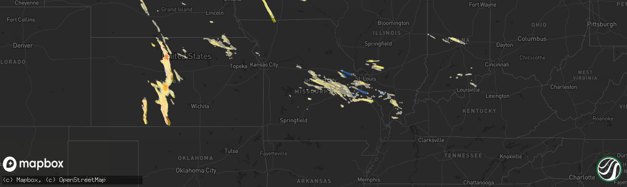
Hail Map in Missouri on July 16, 2023
The weather event in Missouri on July 16, 2023 includes Hail, Wind, and Tornado maps. 21 states and 795 cities were impacted and suffered possible damage. The total estimated number of properties impacted is 9,111.
Hail
Wind
Tornado
9,111
Estimated number of impacted properties by a 1.00" hail or larger0
Estimated number of impacted properties by a 1.75" hail or larger0
Estimated number of impacted properties by a 2.50" hail or largerStorm reports in Missouri
Missouri
| Date | Description |
|---|---|
| 07/16/20233:52 PM CDT | Large oak tree snapped off. Via twitter with picture. |
| 07/16/20233:46 PM CDT | Report from mping: 3-inch tree limbs broken; power poles broken. |
| 07/16/20233:46 PM CDT | Several large trees and tree limbs blown down around pevely and herculaneum areas. Via pictures on facebook. |
| 07/16/20233:46 PM CDT | Report from mping: 3-inch tree limbs broken; power poles broken. Time estimated from radar. |
| 07/16/20233:41 PM CDT | Report from mping: 3-inch tree limbs broken; power poles broken. |
| 07/16/20233:40 PM CDT | Report from mping: 3-inch tree limbs broken; power poles broken. |
| 07/16/20233:39 PM CDT | Report from mping: 3-inch tree limbs broken; power poles broken. |
| 07/16/20233:38 PM CDT | Report from mping: 1-inch tree limbs broken; shingles blown off. Time estimated from radar. |
| 07/16/20233:35 PM CDT | Report from mping: 1-inch tree limbs broken; shingles blown off. |
| 07/16/20233:32 PM CDT | Wind estimated 50-60 mph at hampton ave and i-44. |
| 07/16/20233:27 PM CDT | In town. |
| 07/16/20233:19 PM CDT | A local report indicates 60 MPH wind near Old Mines |
| 07/16/20233:15 PM CDT | Thunderstorm winds snapped off a power pole with the transformer landing in nearby tree. Via picture on facebook post. |
| 07/16/20233:11 PM CDT | Large tree limb blown down. Via picture on twitter. |
| 07/16/20233:10 PM CDT | Several large tree limbs blown down. |
| 07/16/20233:07 PM CDT | Several large tree limbs blown down near intersection of highway 94 and pralle lane. Winds estimated around 60 mph. |
| 07/16/20233:05 PM CDT | Sign blown over onto a car. |
| 07/16/20233:03 PM CDT | Tree blown down and penny sized hail near intersection of highway 94 and highway dd. Via facebook post. |
| 07/16/20232:55 PM CDT | Numerous trees and power lines down reported by off-duty nws employee. |
| 07/16/20232:50 PM CDT | Report from mping: 1-inch tree limbs broken; shingles blown off. Time estimated from radar. |
| 07/16/20232:46 PM CDT | Large tree blown down on a road in town. Via picture on facebook. |
| 07/16/20232:45 PM CDT | Tree into powerline at wilf flower ln and hwy ee. |
| 07/16/20232:45 PM CDT | Report from mping: 3-inch tree limbs broken; power poles broken. |
| 07/16/20232:42 PM CDT | Tree down on powerline causing an outage. Time based on radar estimate. |
| 07/16/20232:40 PM CDT | Power lines down at n second and e main street. |
| 07/16/20232:24 PM CDT | Tree down on powerline causing outages. Time based on radar estimate. |
| 07/16/20232:21 PM CDT | A local report indicates 72 MPH wind near 3 NNE Warrenton |
| 07/16/20231:49 PM CDT | Two trees down over the roadway... One flag pole pushed into powerlines. |
| 07/16/20231:15 PM CDT | Trees down. Time based on radar. |
| 07/16/20231:00 PM CDT | Tree down on hwy 87 north of eldon. |
| 07/16/20234:39 AM CDT | Report from mping: quarter |
| 07/16/20234:31 AM CDT | Time estimated from radar. |
| 07/16/20233:55 AM CDT | Report from mping: quarter |
| 07/16/20233:49 AM CDT | Report from mping: quarter |
| 07/16/20233:43 AM CDT | Delayed report. Small trees down. Time estimated from radar. |
All States Impacted by Hail Map on July 16, 2023
Cities Impacted by Hail Map on July 16, 2023
- Corning, KS
- Centralia, KS
- Goff, KS
- Talco, TX
- Mount Pleasant, TX
- Winfield, TX
- Mount Vernon, TX
- Cookville, TX
- Omaha, TX
- Scroggins, TX
- Leesburg, TX
- Pittsburg, TX
- Ore City, TX
- Daingerfield, TX
- Gilmer, TX
- Naples, TX
- Marietta, TX
- Hughes Springs, TX
- Avinger, TX
- Diana, TX
- Lone Star, TX
- Douglassville, TX
- Linden, TX
- Holdrege, NE
- Funk, NE
- Campbell, TX
- Cumby, TX
- Sulphur Springs, TX
- Havensville, KS
- Soldier, KS
- Colbert, OK
- Spearville, KS
- Emmett, KS
- Burchard, NE
- Axtell, KS
- Summerfield, KS
- Paris, TX
- Hanover, KS
- Point, TX
- Emory, TX
- Longview, TX
- Clatonia, NE
- Cortland, NE
- Hallam, NE
- Wetmore, KS
- Mill Creek, OK
- Mannsville, OK
- Riverdale, NE
- Windom, TX
- Honey Grove, TX
- Ben Franklin, TX
- Pecan Gap, TX
- Ladonia, TX
- Klondike, TX
- Cooper, TX
- Roxton, TX
- Bennington, OK
- Walters, OK
- Geronimo, OK
- Sumner, TX
- Arthur City, TX
- Holton, KS
- Pawnee City, NE
- Platte City, MO
- Dearborn, MO
- Weston, MO
- Telephone, TX
- Winnsboro, TX
- Waterville, KS
- Bremen, KS
- Home, KS
- Marysville, KS
- Onaga, KS
- Frankfort, KS
- Duncan, OK
- Quitman, TX
- Mineola, TX
- Alba, TX
- Blue Rapids, KS
- Powderly, TX
- Baileyville, KS
- Springer, OK
- Westville, FL
- Ponce De Leon, FL
- Hendrix, OK
- Delia, KS
- Vermillion, KS
- Ravenna, TX
- Petty, TX
- Ivanhoe, TX
- Arlington, TX
- Fort Worth, TX
- Beattie, KS
- Seneca, KS
- Wolfe City, TX
- Commerce, TX
- Wills Point, TX
- Davis, OK
- Bokchito, OK
- Savoy, TX
- Hollenberg, KS
- Oketo, KS
- Morrowville, KS
- Washington, KS
- Jefferson, TX
- Harleton, TX
- Marshall, TX
- Karnack, TX
- Bivins, TX
- Mooringsport, LA
- Waskom, TX
- Shreveport, LA
- Oil City, LA
- Belcher, LA
- Vivian, LA
- Blanchard, LA
- Warrenton, MO
- Wright City, MO
- Foristell, MO
- Wentzville, MO
- Marthasville, MO
- Haughton, LA
- Minden, LA
- Benton, LA
- Bossier City, LA
- Cotton Valley, LA
- Barksdale Afb, LA
- Princeton, LA
- Doyline, LA
- Defiance, MO
- O'Fallon, MO
- Lake Saint Louis, MO
- Kensington, KS
- Agra, KS
- Athol, KS
- Gaylord, KS
- Cedar, KS
- Phillipsburg, KS
- Sibley, LA
- Jamestown, LA
- Dubberly, LA
- Heflin, LA
- Homer, LA
- Athens, LA
- Arcadia, LA
- Dubach, LA
- Gibsland, LA
- Simsboro, LA
- Bienville, LA
- Quitman, LA
- Ruston, LA
- Shipman, IL
- Carlinville, IL
- Festus, MO
- Hillsboro, MO
- Pevely, MO
- Herculaneum, MO
- Osborne, KS
- Portis, KS
- Alton, KS
- Glade, KS
- Valmeyer, IL
- Crystal City, MO
- Prairie Du Rocher, IL
- Fults, IL
- Red Bud, IL
- Grambling, LA
- Farmerville, LA
- Choudrant, LA
- Downsville, LA
- Calhoun, LA
- Chatham, LA
- Eros, LA
- West Monroe, LA
- Waldo, KS
- Natoma, KS
- Columbia, LA
- Luray, KS
- Paradise, KS
- Lucas, KS
- Russell, KS
- Bunker Hill, KS
- Dorrance, KS
- Sorento, IL
- Walshville, IL
- Panama, IL
- Donnellson, IL
- Greenville, IL
- Wilson, KS
- Oelrichs, SD
- Chadron, NE
- Pine Ridge, SD
- Lebanon, IN
- Brownsburg, IN
- Zionsville, IN
- Pittsboro, IN
- Whitestown, IN
- Indianapolis, IN
- Hay Springs, NE
- Hoisington, KS
- Claflin, KS
- Holyrood, KS
- Great Bend, KS
- Ellinwood, KS
- Bison, KS
- Otis, KS
- Rush Center, KS
- Albert, KS
- Olmitz, KS
- Pawnee Rock, KS
- St John, KS
- Larned, KS
- Wounded Knee, SD
- Batesland, SD
- Manderson, SD
- Stover, MO
- Covington, IN
- Perrysville, IN
- Buffalo, MO
- Meta, MO
- Abita Springs, LA
- Covington, LA
- Herrin, IL
- Johnston City, IL
- Marion, IL
- Jena, LA
- Jonesville, LA
- Bland, MO
- Mount Sterling, MO
- Owensville, MO
- Hermann, MO
- Morrison, MO
- Ringgold, LA
- Mount Olive, IL
- Stoutland, MO
- Montreal, MO
- Kilgore, TX
- Dodson, LA
- Rocky Mount, MO
- Eldon, MO
- Como, TX
- Fidelity, IL
- Piasa, IL
- Brighton, IL
- Magnolia, AR
- Bogalusa, LA
- Quincy, MO
- Wheatland, MO
- Campti, LA
- Natchitoches, LA
- Edgemont, SD
- Nacogdoches, TX
- Franklinton, LA
- Kiln, MS
- Tullos, LA
- Jewell, KS
- Amite, LA
- Vancleave, MS
- Carmel, IN
- Lebanon, KS
- Smith Center, KS
- Phillips, WI
- Kentwood, LA
- Springhill, LA
- Taylor, AR
- Russellville, MO
- Barnett, MO
- Randall, KS
- Jamestown, KS
- Beloit, KS
- Moss Point, MS
- Belle, MO
- Sainte Genevieve, MO
- Castor, LA
- Saint Thomas, MO
- Henley, MO
- Tuscumbia, MO
- Logansport, LA
- Jupiter, FL
- Hobe Sound, FL
- Mansfield, LA
- Osyka, MS
- Freeburg, MO
- Argyle, MO
- Koeltztown, MO
- Jefferson City, MO
- Saint Elizabeth, MO
- Eugene, MO
- Westphalia, MO
- Staunton, IL
- Phillipsburg, MO
- Jeanerette, LA
- Baldwin, LA
- Franklin, LA
- Coushatta, LA
- Jonesburg, MO
- Cuba, MO
- Ashland, LA
- Sullivan, MO
- Richwoods, MO
- Lonedell, MO
- Netawaka, KS
- Glenmora, LA
- Joaquin, TX
- Grand Cane, LA
- Lisbon, LA
- Litchfield, IL
- Marksville, LA
- Hawkins, TX
- New Iberia, LA
- Delcambre, LA
- Madisonville, LA
- Glasco, KS
- Simpson, KS
- Sarepta, LA
- Plain Dealing, LA
- Magnolia, MS
- Centreville, MS
- Olla, LA
- Trout, LA
- Harrisonburg, LA
- New Douglas, IL
- Leasburg, MO
- Riverton, NE
- Carriere, MS
- Picayune, MS
- Cairo, GA
- Whigham, GA
- Robertsville, MO
- Belle Rose, LA
- Richland, MO
- Sikes, LA
- Hineston, LA
- Lettsworth, LA
- Bourbon, MO
- Bainbridge, GA
- Climax, GA
- Linn, MO
- Loose Creek, MO
- Damascus, GA
- Hallsville, TX
- Independence, LA
- Greenville, FL
- Monterey, LA
- Dittmer, MO
- Catawissa, MO
- Cedar Hill, MO
- Woodbine, GA
- Poplarville, MS
- Potosi, MO
- Goldonna, LA
- Natchez, MS
- Versailles, MO
- Olean, MO
- Gillespie, IL
- Butler, IL
- Chesterfield, IL
- Medora, IL
- Greensburg, LA
- Saint Charles, MO
- Saint Peters, MO
- Ponchatoula, LA
- Hammond, LA
- Pollock, LA
- Glen Elder, KS
- Pittsburg, IL
- Bush, LA
- Bunker Hill, IL
- Pocahontas, IL
- Worden, IL
- Livingston, IL
- Alhambra, IL
- Fayette, MS
- Union Church, MS
- Pattison, MS
- Lorman, MS
- Macksville, KS
- Belpre, KS
- Hazlehurst, MS
- Hermanville, MS
- Alliance, NE
- Ellsworth, NE
- Gordon, NE
- Merriman, NE
- Byers, KS
- Iuka, KS
- Pratt, KS
- Haviland, KS
- Lakeside, NE
- Bingham, NE
- Oshkosh, NE
- Coats, KS
- Sawyer, KS
- Nekoma, KS
- Ashby, NE
- Sun City, KS
- Medicine Lodge, KS
- Lewellen, NE
- Arthur, NE
- Lemoyne, NE
- Farmington, CT
- West Hartford, CT
- New Britain, CT
- Newington, CT
- Hartford, CT
- Wethersfield, CT
- East Hartford, CT
- Windsor, CT
- South Windsor, CT
- Berlin, CT
- Rocky Hill, CT
- East Berlin, CT
- Cromwell, CT
- Glastonbury, CT
- South Glastonbury, CT
- Manchester, CT
- Vernon Rockville, CT
- Bolton, CT
- Coventry, CT
- Stafford Springs, CT
- Tolland, CT
- Ellington, CT
- Willington, CT
- Storrs Mansfield, CT
- Keystone, NE
- Offerle, KS
- Bucklin, KS
- Ford, KS
- Lewis, KS
- Hudson, KS
- Sylvia, KS
- Lake City, KS
- Minneola, KS
- Ashland, KS
- Hardtner, KS
- Kiowa, KS
- Creal Springs, IL
- Fort Necessity, LA
- Winnsboro, LA
- Duson, LA
- Lafayette, LA
- Muscoda, WI
- Boscobel, WI
- Kingman, IN
- Veedersburg, IN
- Saint Marys, KS
- Mobile, AL
- Eight Mile, AL
- Dequincy, LA
- Ragley, LA
- New Ross, IN
- Ladoga, IN
- Roachdale, IN
- North Salem, IN
- Crawfordsville, IN
- Marshall, IN
- Greenfield, IN
- Ellsworth, KS
- Lorraine, KS
- Tallulah, LA
- Newellton, LA
- Rushville, NE
- Golconda, IL
- Simpson, IL
- Vienna, IL
- Waupaca, WI
- Amherst, WI
- Merrimac, WI
- North Freedom, WI
- Lodi, WI
- Baraboo, WI
- Prairie Du Sac, WI
- Circleville, KS
- Roxie, MS
- Campbellsburg, IN
- Clayton, LA
- Lake Charles, LA
- Mccordsville, IN
- Ferriday, LA
- Vicksburg, MS
- Sicily Island, LA
- Gilbert, LA
- West Frankfort, IL
- Carterville, IL
- Stonefort, IL
- Energy, IL
- Fort Lauderdale, FL
- Lucedale, MS
- Kanopolis, KS
- Sylvan Grove, KS
- Loganville, WI
- Plain, WI
- Woodville, MS
- Reeves, LA
- Wesson, MS
- Geneseo, KS
- Porterfield, WI
- Wallace, MI
- Neenah, WI
- Kinder, LA
- Mitchell, IN
- Orleans, IN
- Richland Center, WI
- Soldiers Grove, WI
- Blue River, WI
- Hillpoint, WI
- Rayne, LA
- Gays Mills, WI
- Cazenovia, WI
- Jennings, LA
- Sawyerville, IL
- Enterprise, LA
- Reedsville, WI
- Abbeville, LA
- Maurice, LA
- New Burnside, IL
- Menasha, WI
- Larsen, WI
- Loxley, AL
- Bay Minette, AL
- Stapleton, AL
- Broxton, GA
- Aimwell, LA
- Jamestown, IN
- Eddyville, IL
- Eden, WI
- Pepperell, MA
- Townsend, MA
- Hollis, NH
- Brookline, NH
- Merrimack, NH
- Nashua, NH
- Amherst, NH
- Bloomfield, CT
- Kimballton, IA
- Audubon, IA
- Elk Horn, IA
- Exira, IA
- Brayton, IA
- Anita, IA
- Stuart, IA
- Menlo, IA
- Sauk City, WI
- Poynette, WI
- Arlington, WI
- Fond Du Lac, WI
- Winterset, IA
- Earlham, IA
- Dexter, IA
- Saint Cloud, WI
- Campbellsport, WI
- Mount Calvary, WI
- Glenbeulah, WI
- Persia, IA
- Shelby, IA
- Avoca, IA
- Columbia, IL
- Saint Charles, IA
- Prole, IA
- Bevington, IA
- Indianola, IA
- Atlantic, IA
- Blackwell, MO
- De Soto, MO
- Coulterville, IL
- Pinckneyville, IL
- Tamaroa, IL
- Du Quoin, IL
- California, MO
- Lohman, MO
- Centertown, MO
- Marshall, MO
- Harlan, IA
- Oconto, NE
- Portsmouth, IA
- Lexington, NE
- Callaway, NE
- Danville, IN
- Eddyville, NE
- Campbell Hill, IL
- McCracken, KS
- Alexander, KS
- Deputy, IN
- Scottsburg, IN
- Woodbine, IA
- Panama, IA
- Gerald, MO
- Rosebud, MO
- New Bloomfield, MO
- Arnold, NE
- Saint Louis, MO
- Chamois, MO
- Vallonia, IN
- Tebbetts, MO
- Austin, IN
- Salem, IN
- Galatia, IL
- Downs, KS
- High Ridge, MO
- Eureka, MO
- House Springs, MO
- Rio Grande City, TX
- Wilcox, NE
- Leslie, MO
- Beaufort, MO
- Stafford, KS
- Saint Clair, MO
- Goshen, KY
- Charlestown, IN
- Union, MO
- Marissa, IL
- Adair, IA
- Hartsburg, MO
- Jamestown, MO
- Boonville, MO
- Columbia, MO
- Wooldridge, MO
- Prairie Home, MO
- Ashland, MO
- Bonnots Mill, MO
- Holts Summit, MO
- Mulkeytown, IL
- Turon, KS
- Comanche, OK
- Bloomsdale, MO
- North Vernon, IN
- Vernon, IN
- New Athens, IL
- Imperial, MO
- Pacific, MO
- Ballwin, MO
- Fenton, MO
- Freeburg, IL
- Waterloo, IL
- Millstadt, IL
- East Carondelet, IL
- Wildwood, MO
- Arnold, MO
- Valley Park, MO
- Belleville, IL
- Smithton, IL
- Sherwood, WI
- New Haven, MO
- New Palestine, IN
- Brownstown, IN
- Crestwood, KY
- Buckner, KY
- La Grange, KY
- Marysville, IN
- Nabb, IN
- Otisco, IN
- Percy, IL
- Cutler, IL
- Sesser, IL
- Nelson, MO
- Blackwater, MO
- Wright, KS
- Dodge City, KS
- Crothersville, IN
- Hamlin, IA
- Fontanelle, IA
- Bridgewater, IA
- Soldier, IA
- Moorhead, IA
- Dunlap, IA
- Logan, IA
- Neola, IA
- Minden, IA
- Herman, NE
- Tekamah, NE
- Craig, NE
- Blair, NE
- Greenfield, IA
- Creston, IA
- Prescott, IA
- Orient, IA
- Saint Mary, MO
- Elgin, NE
- Petersburg, NE
- Albion, NE
- Cromwell, IA
- Newman Grove, NE
- Lenox, IA
- Shannon City, IA
- Perryville, MO
- Decatur, NE
- Lindsay, NE
- Laurel, NE
- Dixon, NE
- Coleridge, NE
- Diagonal, IA
- Mount Ayr, IA
- Saint Edward, NE
- Madison, NE
- Humphrey, NE
- Wayne, NE
- Concord, NE
- Blencoe, IA
- Little Sioux, IA
- Knoxville, IA
- Harvey, IA
- Tracy, IA
- Bussey, IA
- Oskaloosa, IA
- Creston, NE
- Wakefield, NE
- Eddyville, IA
- Leighton, IA
- Leigh, NE
- Hatfield, MO
- Eagleville, MO
- Martinsville, MO
- Kellerton, IA
- Franklin, NE
- Bloomington, NE
- Pisgah, IA
- Marne, IA
- Wiota, IA
- Kiron, IA
- Vail, IA
- Deloit, IA
- Arcadia, IA
- Breda, IA
- Westside, IA
- Gray, IA
- Manning, IA
- Manilla, IA
- Casey, IA
- Aspinwall, IA
- Irwin, IA
- Naponee, NE
- Hildreth, NE
- Oakland, NE
- Karnak, IL
- Belknap, IL
- Boss, MO
- Davisville, MO
- Ellis Grove, IL
- Walsh, IL
- Platte Center, NE
- Bonne Terre, MO
- Park Hills, MO
- Leadwood, MO
- Mineral Point, MO
- Central City, NE
- Marquette, NE
- Hordville, NE
- Lyons, NE
- Royalton, IL
- Freeman Spur, IL
- Orient, IL
- Zeigler, IL
- Steelville, MO
- Raleigh, IL
- Irondale, MO
- Farmington, MO
- French Village, MO
- Cadet, MO
- Elkville, IL
- Vergennes, IL
- Saint Marys, IA
- Patterson, IA
- Viburnum, MO
- Bixby, MO
- Cypress, IL
- Sumner, NE
- Broken Bow, NE
- Overton, NE
- Onawa, IA
- Belgrade, MO
- Columbus, NE
- Saint James, MO
- Whittington, IL
- Benton, IL
- Scheller, IL
- Chester, IL
- Vichy, MO
- Vienna, MO
- Fletcher, MO
- Axtell, NE
- Elm Creek, NE
- Hancock, IA
- Missouri Valley, IA
- Anselmo, NE
- Hampton, NE
- Bradshaw, NE
- Polk, NE
- Mondamin, IA
- Stanton, NE
- Norfolk, NE
- Massena, IA
- Tingley, IA
- Kirkman, IA
- Fulton, MO
- Redfield, IA


