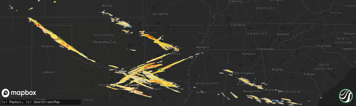
Hail Map in Arkansas on June 13, 2023
The weather event in Arkansas on June 13, 2023 includes Hail, Wind, and Tornado maps. 16 states and 797 cities were impacted and suffered possible damage. The total estimated number of properties impacted is 112,585.
Hail
Wind
Tornado
112,585
Estimated number of impacted properties by a 1.00" hail or larger34,378
Estimated number of impacted properties by a 1.75" hail or larger3,538
Estimated number of impacted properties by a 2.50" hail or largerStorm reports in Arkansas
Arkansas
| Date | Description |
|---|---|
| 06/13/20236:11 PM CDT | A local report indicates 1.75 inch wind near Antoine |
| 06/13/20236:09 PM CDT | Public reported hail a little larger than a hen egg at the family dollar in dierks. Time estimated by radar. |
| 06/13/20236:09 PM CDT | Public reported hail a little larger than a hen egg at the family dolla |
| 06/13/20236:08 PM CDT | A local report indicates 1.75 inch wind near Delight |
| 06/13/20236:08 PM CDT | Report from mping: quarter |
| 06/13/20236:06 PM CDT | A local report indicates 1.75 inch wind near 1 SW Antoine |
| 06/13/20235:55 PM CDT | A local report indicates 2.50 inch wind near 1 SSE Roy |
| 06/13/20235:47 PM CDT | Law enforcement reports quarter sized hail at the sevier county sheriffs office. |
| 06/13/20235:43 PM CDT | Public reported hail up to hen egg size. Time estimated by radar. |
| 06/13/20235:31 PM CDT | A local report indicates 2.75 inch wind near Winthrop |
| 06/13/20235:25 PM CDT | Trained spotter report of 2.75 inch hail 5 miles nnw of ben lomond. Time estimated using radar. |
| 06/13/20235:23 PM CDT | A local report indicates 2.50 inch wind near 5 NW Ben Lomond |
| 06/13/20238:01 AM CDT | Ashdown paper mill. |
| 06/13/20236:58 AM CDT | Large portion of a tree down over a truck. |
| 06/13/20236:50 AM CDT | A local report indicates 1.50 inch wind near Austin |
| 06/13/20236:45 AM CDT | A local report indicates 1.75 inch wind near 1 NW Woodlawn Addition |
| 06/13/20236:37 AM CDT | Report via social media. |
| 06/13/20236:34 AM CDT | Report from mping: quarter |
| 06/13/20236:30 AM CDT | A local report indicates 1.75 inch wind near 3 ENE Vilonia |
| 06/13/20236:25 AM CDT | A local report indicates 1.50 inch wind near 2 S Holland |
| 06/13/20236:12 AM CDT | Report via social media shows tree down over a dirt road. |
| 06/13/20234:25 AM CDT | A local report indicates 1.75 inch wind near 1 W West Fork |
| 06/13/20234:13 AM CDT | A local report indicates 1.75 inch wind near Winslow |
| 06/13/20234:08 AM CDT | Corrects previous hail report from 1 w west fork. |
| 06/13/20231:03 AM CDT | Report from mping: quarter |
| 06/13/202312:28 AM CDT | Reports of quarter sized hail with thunderstorm near arkansas 29 and county road 16... North of canfield. |
| 06/13/202312:02 AM CDT | Report from mping: ping pong ball |
| 06/12/202310:42 PM CDT | A local report indicates 1.25 inch wind near Bradley |
| 06/12/20239:25 PM CDT | A local report indicates 1.75 inch wind near 6 SW Taylor |
| 06/12/20239:05 PM CDT | Report from mping: golf ball |
| 06/12/20239:03 PM CDT | Sutton community. |
| 06/12/20238:22 PM CDT | A local report indicates 1.75 inch wind near 4 NW Nashville |
| 06/12/20238:09 PM CDT | Public reported hail up to at least quarter size at the dollar general in lockesburg. |
All States Impacted by Hail Map on June 13, 2023
Cities Impacted by Hail Map on June 13, 2023
- Mount Vernon, TX
- Winnsboro, TX
- Scroggins, TX
- Mount Pleasant, TX
- Pittsburg, TX
- Leesburg, TX
- Gilmer, TX
- De Kalb, TX
- New Boston, TX
- Foreman, AR
- Hooks, TX
- Ashdown, AR
- Texarkana, TX
- Ogden, AR
- Marietta, OK
- Lebanon, OK
- Kingston, OK
- Whitesboro, TX
- Cartwright, OK
- Calera, OK
- Pottsboro, TX
- Denison, TX
- Colbert, OK
- Bonham, TX
- Ladonia, TX
- Windom, TX
- Honey Grove, TX
- Roxton, TX
- Pecan Gap, TX
- Cooper, TX
- Sulphur Springs, TX
- Saltillo, TX
- Sulphur Bluff, TX
- Dike, TX
- Ore City, TX
- Lone Star, TX
- Avinger, TX
- Jefferson, TX
- Diana, TX
- Marshall, TX
- Karnack, TX
- Mooringsport, LA
- Ramer, AL
- Pattonville, TX
- Blossom, TX
- Deport, TX
- Detroit, TX
- Bogata, TX
- Clarksville, TX
- Annona, TX
- Avery, TX
- Grady, AL
- Troy, AL
- Shreveport, LA
- Ivanhoe, TX
- Telephone, TX
- Satartia, MS
- Bentonia, MS
- Valley Park, MS
- Hughes Springs, TX
- Daingerfield, TX
- Gainesville, TX
- Sadler, TX
- Lapine, AL
- Cruger, MS
- Sherman, TX
- Howe, TX
- Pine Hill, AL
- Paris, TX
- Savoy, TX
- Como, TX
- Pickton, TX
- Petty, TX
- Camden, AL
- Catherine, AL
- Arlington, AL
- Whitewright, TX
- Ector, TX
- Tom Bean, TX
- Commerce, TX
- Klondike, TX
- Emerson, AR
- Dodd City, TX
- Hope Hull, AL
- Highland Home, AL
- Letohatchee, AL
- Brookston, TX
- Toxey, AL
- Butler, AL
- Omaha, TX
- Harleton, TX
- Naples, TX
- Thomaston, AL
- Magnolia, AL
- Thomasville, AL
- Lake Creek, TX
- Talco, TX
- Meridian, MS
- Needham, AL
- Quitman, MS
- Enterprise, MS
- Stonewall, MS
- Winfield, TX
- Ravenna, TX
- Linden, AL
- Dixons Mills, AL
- Demopolis, AL
- Sweet Water, AL
- Leonard, TX
- Randolph, TX
- Wolfe City, TX
- Bells, TX
- Trenton, TX
- Banks, AL
- Kaufman, TX
- Terrell, TX
- Wills Point, TX
- Irving, TX
- Grand Prairie, TX
- Dallas, TX
- Simms, TX
- Abbeville, AL
- Fort Worth, TX
- Kennedale, TX
- Leesburg, GA
- De Soto, GA
- Cordele, GA
- Warwick, GA
- Arlington, TX
- Mansfield, TX
- Arabi, GA
- Balch Springs, TX
- Cedar Hill, TX
- Mesquite, TX
- Fort Gaines, GA
- Coleman, GA
- Ashburn, GA
- Canton, TX
- Edgewood, TX
- Grand Saline, TX
- Van, TX
- Pueblo, CO
- Forney, TX
- Midlothian, TX
- Desoto, TX
- Red Oak, TX
- Rebecca, GA
- Sunnyvale, TX
- Crandall, TX
- Rockwall, TX
- Royse City, TX
- Lindale, TX
- Lancaster, TX
- Ferris, TX
- Palmer, TX
- Quinlan, TX
- Caddo Mills, TX
- Greenville, TX
- Fort Lauderdale, FL
- Ennis, TX
- Lone Oak, TX
- Garland, TX
- Waxahachie, TX
- Campbell, TX
- Ocilla, GA
- Wray, GA
- Boone, CO
- Cumby, TX
- Brashear, TX
- Pritchett, CO
- Las Animas, CO
- Grenville, NM
- Kenton, OK
- Ben Wheeler, TX
- Atmore, AL
- Tyler, TX
- Linden, TX
- Cuthbert, GA
- Shellman, GA
- Dawson, GA
- Oakfield, GA
- Albany, GA
- Ambrose, GA
- Sylvester, GA
- Boise City, OK
- Felt, OK
- Moultrie, GA
- Norman Park, GA
- Omega, GA
- Tifton, GA
- Sumner, GA
- Lenox, GA
- Sparks, GA
- Nashville, GA
- Enigma, GA
- Alapaha, GA
- Jay, FL
- Arp, TX
- Overton, TX
- Dalhart, TX
- Sheridan Lake, CO
- Henderson, TX
- Tribune, KS
- Idabel, OK
- Haworth, OK
- Winthrop, AR
- Bagwell, TX
- Garvin, OK
- Lockesburg, AR
- Stratford, TX
- Menard, TX
- Eden, TX
- Horatio, AR
- Mineral Springs, AR
- Nashville, AR
- Brady, TX
- De Queen, AR
- Eagletown, OK
- Melvin, TX
- Troup, TX
- Dumas, TX
- Sunray, TX
- Carthage, TX
- Cactus, TX
- Dierks, AR
- Gruver, TX
- Lakin, KS
- Murfreesboro, AR
- Delight, AR
- Antoine, AR
- Okolona, AR
- Arkadelphia, AR
- Hext, TX
- Hartsfield, GA
- Crestview, FL
- Goshen, AL
- Walsenburg, CO
- McCaskill, AR
- Slocomb, AL
- Westville, FL
- Hartford, AL
- Black, AL
- Bonifay, FL
- Odum, GA
- Ozan, AR
- Douglas, GA
- Chattahoochee, FL
- Grand Ridge, FL
- Sneads, FL
- Marianna, FL
- Bainbridge, GA
- Rowlett, TX
- Bryceville, FL
- Vivian, LA
- Oil City, LA
- Whigham, GA
- Climax, GA
- Little River, AL
- Eads, CO
- Mineola, TX
- Quitman, TX
- Big Sandy, TX
- Hawkins, TX
- Morgan, GA
- Selman City, TX
- Clayton, NM
- Adel, GA
- Bossier City, LA
- Fitzgerald, GA
- Rochelle, GA
- Laurel Hill, FL
- Eufaula, AL
- Georgetown, GA
- Morris, GA
- Macclenny, FL
- Jacksonville, FL
- Clewiston, FL
- Clayton, AL
- Downs, KS
- Cottonwood, AL
- Donalsonville, GA
- Kim, CO
- Milton, FL
- Bronwood, GA
- Doerun, GA
- Century, FL
- Flomaton, AL
- Holt, FL
- Citronelle, AL
- McDavid, FL
- Blakely, GA
- Kilgore, TX
- Pelham, GA
- Meigs, GA
- Brinson, GA
- Beloit, KS
- Glen Elder, KS
- Honoraville, AL
- Greenville, AL
- Luverne, AL
- Fort Deposit, AL
- Brundidge, AL
- Deer Park, AL
- Camilla, GA
- Glen Saint Mary, FL
- Saint George, GA
- Sanderson, FL
- Caryville, FL
- Ponce De Leon, FL
- Alma, GA
- Point, TX
- Hollywood, FL
- Naylor, GA
- Moody Afb, GA
- Hahira, GA
- Lakeland, GA
- Valdosta, GA
- Model, CO
- Vinegar Bend, AL
- Blevins, AR
- Okeechobee, FL
- Pansey, AL
- Ashford, AL
- Gordon, AL
- Dothan, AL
- Jakin, GA
- Damascus, GA
- Clio, AL
- Ariton, AL
- Louisville, AL
- Hayneville, AL
- Chula, GA
- Pompano Beach, FL
- Cookville, TX
- Shorterville, AL
- Nicholls, GA
- Sandpoint, ID
- Lorida, FL
- Flowood, MS
- Pearl, MS
- Umpire, AR
- Tatum, TX
- McIntosh, AL
- Jackson, AL
- Labelle, FL
- Coffeeville, AL
- Ione, WA
- Cusick, WA
- Quitman, GA
- Leary, GA
- Edison, GA
- La Junta, CO
- Gladewater, TX
- Winona, TX
- Scurry, TX
- Texarkana, AR
- Mabank, TX
- Sycamore, GA
- Broxton, GA
- Hutchins, TX
- Duncanville, TX
- Defuniak Springs, FL
- Jupiter, FL
- Stockton, AL
- Willacoochee, GA
- Seagoville, TX
- Geneva, AL
- Graceville, FL
- Baker, FL
- Chandler, TX
- Jackson, MS
- Vernon, FL
- Brownsboro, TX
- Iron City, GA
- Colquitt, GA
- Cairo, GA
- Atlantic Beach, FL
- Ponte Vedra, FL
- Saint Johns, FL
- Whitehouse, TX
- Bivins, TX
- Kemp, TX
- Long Branch, TX
- Gary, TX
- Douglassville, TX
- Marietta, TX
- Stinnett, TX
- Morse, TX
- Borger, TX
- Yantis, TX
- Atlanta, TX
- Doddridge, AR
- Ida, LA
- Rodessa, LA
- Plain Dealing, LA
- Miami, TX
- Pampa, TX
- Skellytown, TX
- White Deer, TX
- Groom, TX
- Mclean, TX
- Mobeetie, TX
- Shamrock, TX
- Fruitvale, TX
- Wellington, TX
- Wheeler, TX
- Joaquin, TX
- Tenaha, TX
- Logansport, LA
- Fulton, AR
- Lewisville, AR
- Hope, AR
- Emmet, AR
- Rosston, AR
- Homer, LA
- Arcadia, LA
- Bradley, AR
- Erick, OK
- Mangum, OK
- Willow, OK
- Hollis, OK
- Vinson, OK
- Dubach, LA
- Taylor, AR
- Shongaloo, LA
- Springhill, LA
- Haynesville, LA
- Sarepta, LA
- Prescott, AR
- Bluff City, AR
- Chidester, AR
- Altus, OK
- Blair, OK
- Altus Afb, OK
- Broken Bow, OK
- Bernice, LA
- Farmerville, LA
- Choudrant, LA
- Downsville, LA
- Maud, TX
- Queen City, TX
- Olustee, OK
- Lisbon, LA
- Fouke, AR
- Garland City, AR
- Grannis, AR
- Gillham, AR
- Summerfield, LA
- Minden, LA
- Cotton Valley, LA
- Headrick, OK
- Tipton, OK
- Frederick, OK
- Jesup, GA
- Sylvan Grove, KS
- Barnard, KS
- Lincoln, KS
- Smith Center, KS
- Athol, KS
- Langley, AR
- Newhope, AR
- Deerfield, KS
- Hunter, KS
- Tipton, KS
- Osborne, KS
- Tescott, KS
- Healy, KS
- Jordan Valley, OR
- Eglin Afb, FL
- Magnolia, AR
- Monroe, LA
- Delphos, KS
- Salina, KS
- New Cambria, KS
- Holly, CO
- Granada, CO
- Lamar, CO
- Adrian, OR
- Syracuse, KS
- Burley, ID
- Saint Augustine, FL
- Stockton, KS
- Lebanon, KS
- West Monroe, LA
- Lake City, FL
- Grinnell, KS
- Savannah, GA
- Powderly, TX
- Gurdon, AR
- Valliant, OK
- Hosston, LA
- Athens, LA
- Stockton, GA
- Ponte Vedra Beach, FL
- Oakley, ID
- Beverly, KS
- Bayview, ID
- Glenns Ferry, ID
- Leoti, KS
- Cawker City, KS
- Benton, LA
- Athol, ID
- Hayden, ID
- Emory, TX
- Collyer, KS
- Bloomburg, TX
- Neptune Beach, FL
- Jacksonville Beach, FL
- Flint, TX
- Buckner, AR
- Stamps, AR
- Greenville, FL
- Garden City, KS
- Scott City, KS
- Sale City, GA
- Lake Placid, FL
- Thomasville, GA
- Pembroke Pines, FL
- Alba, TX
- Brunswick, GA
- Nash, TX
- Sparkman, AR
- Camden, AR
- Glenwood, AR
- Caddo Gap, AR
- Bonnerdale, AR
- Royal, AR
- Hot Springs National Park, AR
- Pearcy, AR
- Carthage, AR
- Fordyce, AR
- Rison, AR
- Bearden, AR
- Ivan, AR
- Hot Springs Village, AR
- Lonsdale, AR
- Grapevine, AR
- Kingsland, AR
- Pine Bluff, AR
- Altheimer, AR
- Grady, AR
- Humphrey, AR
- Wabbaseka, AR
- Stuttgart, AR
- Almyra, AR
- Junction City, AR
- Spearsville, LA
- Lillie, LA
- Fairfax, OK
- Wynona, OK
- Pawhuska, OK
- Tulsa, OK
- Marion, LA
- Broken Arrow, OK
- Haskell, OK
- Weiser, ID
- Lexa, AR
- Benton, AR
- Alexander, AR
- Little Rock, AR
- Paron, AR
- Walters, OK
- Temple, OK
- Kaw City, OK
- Newkirk, OK
- Ponca City, OK
- Shidler, OK
- Big Timber, MT
- Greycliff, MT
- Alberta, AL
- Dundee, MS
- West Fork, AR
- Mountain Pine, AR
- Norman, AR
- Sand Springs, OK
- Burbank, OK
- Ruston, LA
- Argonia, KS
- Wilburton, OK
- Red Oak, OK
- Coweta, OK
- Bixby, OK
- Rayville, LA
- Prairie Grove, AR
- Stilwell, OK
- Lincoln, AR
- Morrow, AR
- Evansville, AR
- Winslow, AR
- Canehill, AR
- Bartlesville, OK
- Barnsdall, OK
- Caldwell, KS
- Wellington, KS
- Wagoner, OK
- Chouteau, OK
- Mcalester, OK
- Kirby, AR
- Amity, AR
- Coy, AL
- Arkansas City, KS
- Geuda Springs, KS
- Clarendon, TX
- Bismarck, AR
- Tunica, MS
- Oxford, KS
- Marvell, AR
- Mayfield, KS
- Mount Vernon, AL
- Loveland, OK
- Snyder, OK
- Randlett, OK
- Chattanooga, OK
- Poplar Grove, AR
- Holly Grove, AR
- West Helena, AR
- Eagle, ID
- Garden City, ID
- Brierfield, AL
- Montevallo, AL
- Calera, AL
- Jemison, AL
- Milan, KS
- Conway Springs, KS
- Clearwater, KS
- Belcher, LA
- Perdido, AL
- De Witt, AR
- Simsboro, LA
- Mountainburg, AR
- Ozark, AR
- Elkins, AR
- Oark, AR
- Clarksville, AR
- Altus, AR
- Coal Hill, AR
- Hartman, AR
- Lamar, AR
- Dover, AR
- London, AR
- Titus, AL
- Rockford, AL
- Equality, AL
- Marbury, AL
- Deatsville, AL
- Hector, AR
- Russellville, AR
- Fayetteville, AR
- Combs, AR
- Ozone, AR
- Atkins, AR
- Jerusalem, AR
- Hattieville, AR
- Solgohachia, AR
- Springfield, AR
- Greenbrier, AR
- Conway, AR
- Vilonia, AR
- Pottsville, AR
- Dardanelle, AR
- Ochelata, OK
- Ramona, OK
- Morrilton, AR
- Casa, AR
- Adona, AR
- Plumerville, AR
- El Paso, AR
- Cabot, AR
- Austin, AR
- Beebe, AR
- Talala, OK
- Oologah, OK
- Ward, AR
- Perryville, AR
- Perry, AR
- Houston, AR
- Bigelow, AR
- Claremore, OK
- Chelsea, OK
- Lonoke, AR
- Pryor, OK
- Westville, OK
- Siloam Springs, AR
- Summers, AR
- Watts, OK
- Mount Judea, AR
- Nowata, OK
- North Little Rock, AR
- Welling, OK
- Danville, KS
- Marianna, AR
- Cypress Inn, TN
- Lutts, TN
- Collinwood, TN
- Lanett, AL
- Valley, AL
- Cusseta, AL
- Winfield, KS
- Northport, AL
- Sherwood, AR
- Mayflower, AR
- Hernando, MS
- Reynolds, GA
- Rupert, GA
- Ellaville, GA
- Ideal, GA
- Oglethorpe, GA
- Montezuma, GA
- Kansas, OK
- Skiatook, OK
- Collinston, LA
- Bastrop, LA
- Pelsor, AR
- Catoosa, OK
- Auburn, AL
- Deer, AR
- Hagarville, AR
- Vera, OK
- Collinsville, OK
- Oak Ridge, LA
- Sherrill, AR
- Damascus, AR
- Sterlington, LA
- Millport, AL
- Euless, TX
- London, TX
- Columbus, MS
- West Point, MS
- Starkville, MS
- Searcy, AR
- Romance, AR
- Woodstock, AL
- West Blocton, AL
- Salem, AL
- Phenix City, AL
- Gordo, AL
- Mauk, GA
- Buena Vista, GA
- Tallassee, AL
- Calhoun, LA
- Eros, LA
- Baskin, LA
- Mangham, LA
- Wooster, AR
- Knoxville, AR
- Scranton, AR
- New Blaine, AR
- Delaware, AR
- Dadeville, AL
- Camp Hill, AL
- Notasulga, AL
- Thorsby, AL
- Clanton, AL
- Verbena, AL
- Goodwater, AL
- Kennedy, AL
- Fayette, AL
- Vernon, AL
- Sulligent, AL
- Tuscaloosa, AL
- Centreville, AL
- Brent, AL
- Berry, AL
- Lafayette, AL
- Center Ridge, AR
- Cleveland, AR
- Jacksonville, AR
- Tahlequah, OK
- Proctor, OK
- Caledonia, MS
- Randolph, AL
- Vance, AL
- Coldwater, MS
- Elrod, AL
- Reform, AL
- Mount Vernon, AR
- Alexander City, AL
- Weogufka, AL
- Wetumpka, AL
- Maplesville, AL
- Cottondale, AL
- Opelika, AL
- Helena, AL
- Shelby, AL
- Sylacauga, AL
- Kellyton, AL
- Alabaster, AL
- Eclectic, AL
- Waverly, AL
- Tuskegee, AL
- Bankston, AL
- Steens, MS
- Hamilton, MS
- Delhi, LA
- Inola, OK
- Echola, AL
- Brandon, MS


