Hail Map in Texas on June 12, 2023
The weather event in Texas on June 12, 2023 includes Hail and Wind maps. 15 states and 514 cities were impacted and suffered possible damage. The total estimated number of properties impacted is 268,908.
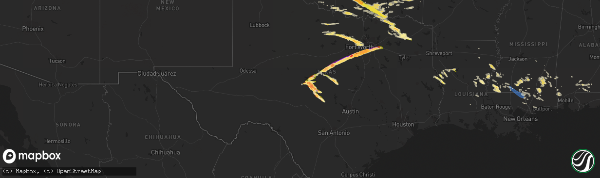
Hail
Wind
268,908
Estimated number of impacted properties by a 1.00" hail or larger181,684
Estimated number of impacted properties by a 1.75" hail or larger237,891
Estimated number of impacted properties by a 2.50" hail or largerStorm reports in Texas
Texas
| Date | Description |
|---|---|
| 06/12/20236:44 PM CDT | Tennis ball size hail. |
| 06/12/20236:41 PM CDT | Hen egg size hail. |
| 06/12/20236:40 PM CDT | Hen egg+ size hail. |
| 06/12/20236:32 PM CDT | A local report indicates 1.00 inch wind near 5 SE Millersview |
| 06/12/20236:16 PM CDT | A local report indicates 1.00 inch wind near 2 ESE Millersview |
| 06/12/202312:44 PM CDT | Hail covering the ground. |
| 06/12/202312:24 PM CDT | Golf ball |
| 06/12/202312:12 PM CDT | A local report indicates 1.25 inch wind near 5 NW Pampa |
| 06/12/202312:12 PM CDT | Corrects previous hail report from 1 sse pampa. Golf ball |
| 06/12/202312:10 PM CDT | A local report indicates 1.75 inch wind near 1 NW Pampa |
| 06/12/202312:09 PM CDT | Half dollar |
| 06/12/202312:09 PM CDT | Numerous reports of large hail fell across pampa. The largest size was baseball size hail that fell. Accumulating hail up to golfball size occurred as well. Many cars i |
| 06/12/202311:40 AM CDT | Emergency manager reported a tree caused damage to a home and powerlines near private road 282. Outflow winds are estimated to be around 40-50mph. |
| 06/12/202310:56 AM CDT | Report from sheriff office. |
| 06/12/20236:58 AM CDT | Public reports of quarter size hail in hurst. |
| 06/12/20236:35 AM CDT | Social media reports of ping pong ball size hail near i-35 and heritage trace pkwy. |
| 06/12/20236:20 AM CDT | Social media report of half dollar size hail near bonds ranch & saginaw blvd. |
| 06/12/20236:18 AM CDT | Reports of quarter size hail nw tarrant county near morris-diddo road and peden road. |
| 06/12/20236:15 AM CDT | Social media reports of golf ball size hail in azle. |
| 06/12/20236:12 AM CDT | Trees down along hwy 19 north of tira near the s sulphur river. Time estimated based on radar. |
| 06/12/20236:00 AM CDT | Amateur radio reported of quarter size hail near tms. |
| 06/12/20235:37 AM CDT | Near boonesville. |
| 06/12/20235:30 AM CDT | Honey grove vol. Fire dept reported numerous large tree branches down in the city. |
| 06/12/20234:51 AM CDT | A local report indicates 1.25 inch wind near 6 ENE Bryson |
| 06/12/20234:45 AM CDT | A local report indicates 1.00 inch wind near 6 ENE Bryson |
| 06/11/202311:25 PM CDT | Delayed report: social media report of quarter size hail in forney. |
| 06/11/202311:05 PM CDT | Egg size hail along great trinity forest way and us 175. |
| 06/11/202311:02 PM CDT | A local report indicates 2.00 inch wind near 2 NE Cedar Hill |
| 06/11/202310:49 PM CDT | Report from mping: tennis ball |
| 06/11/202310:47 PM CDT | Report from mping: quarter |
| 06/11/202310:39 PM CDT | Report from mping: tennis ball |
| 06/11/202310:38 PM CDT | Report from mping: hen egg+ |
| 06/11/202310:37 PM CDT | Report from mping: quarter |
| 06/11/202310:36 PM CDT | Social media photo of measured 4 inch hail. |
| 06/11/202310:36 PM CDT | Social media report of baseball size hail in mansfield. |
| 06/11/202310:35 PM CDT | Social media photos of baseball size hail. |
| 06/11/202310:35 PM CDT | Report from mping: baseball |
| 06/11/202310:35 PM CDT | Report from mping: golf ball |
| 06/11/202310:33 PM CDT | Social media report of measured baseball size hail. |
| 06/11/202310:33 PM CDT | Report from mping: half dollar |
| 06/11/202310:33 PM CDT | Photo passed through from one of our broadcast partners of hail that measured 5 inches. |
| 06/11/202310:32 PM CDT | Social media photo of baseball size hail. |
| 06/11/202310:23 PM CDT | Report from mping: golf ball |
| 06/11/202310:21 PM CDT | A local report indicates 1.75 inch wind near 2 S Godley |
| 06/11/202310:19 PM CDT | Report from mping: golf ball |
| 06/11/202310:18 PM CDT | Social media photo of measured 4 inch hail in burleson. |
| 06/11/202310:15 PM CDT | Report from mping: quarter |
| 06/11/202310:14 PM CDT | Report from mping: tennis ball |
| 06/11/202310:06 PM CDT | Ping pong hail in joshua at fm 917 and hwy 174 via hams. |
| 06/11/202310:06 PM CDT | Report from mping: half dollar |
| 06/11/20239:59 PM CDT | Golf ball size hail at hwy 171 and 2331 in godley via em. |
| 06/11/20239:59 PM CDT | Report from mping: hen egg |
| 06/11/20239:56 PM CDT | Spotter in godley reporting slightly larger than quarter hail via hams. |
| 06/11/20239:52 PM CDT | Report from mping: quarter |
| 06/11/20239:50 PM CDT | Golf ball hail on hwy 167 just east of lake granbury via hams. |
| 06/11/20239:47 PM CDT | Report of golf ball to tennis ball to baseball size hail across pecan plantation. |
| 06/11/20239:46 PM CDT | Tennis ball size hail in pecan plantation via hams. |
| 06/11/20239:36 PM CDT | Golf ball size hail south of tolar via hams. |
| 06/11/20239:27 PM CDT | Report from mping: quarter |
| 06/11/20239:24 PM CDT | A local report indicates 1.25 inch wind near 10 E Mason |
| 06/11/20239:23 PM CDT | Report from mping: golf ball |
| 06/11/20239:21 PM CDT | Quarter hail on hwy 205 east of stephenville via hams. |
| 06/11/20239:11 PM CDT | Report from mping: golf ball |
| 06/11/20239:09 PM CDT | Report from mping: ping pong ball |
| 06/11/20239:08 PM CDT | Golf ball hail in heritage hills south of stephenville. |
| 06/11/20239:02 PM CDT | Email report of ping pong ball size hail 4s of stephenville. |
| 06/11/20238:51 PM CDT | Quarter hail in dublin via hams. |
| 06/11/20238:47 PM CDT | A local report indicates 1.25 inch wind near 2 ESE Owens |
| 06/11/20238:44 PM CDT | Tennis ball size hail along highway 16 north of comanche. |
| 06/11/20238:40 PM CDT | A local report indicates 1.75 inch wind near Katemcy |
| 06/11/20238:16 PM CDT | Golf ball to tennis ball size hail falling north of blanket. |
| 06/11/20238:13 PM CDT | Report of golf ball to tennis ball size hail w of comanche. |
| 06/11/20238:12 PM CDT | Tennis ball. |
| 06/11/20237:56 PM CDT | Corrects time. |
| 06/11/20237:55 PM CDT | A local report indicates 1.75 inch wind near 3 SSE Brady |
| 06/11/20237:54 PM CDT | A local report indicates 1.75 inch wind near Owens |
| 06/11/20237:54 PM CDT | A local report indicates 1.75 inch wind near Owens |
| 06/11/20237:53 PM CDT | A local report indicates 1.50 inch wind near 1 SSW Brady |
| 06/11/20237:45 PM CDT | A local report indicates 1.00 inch wind near 1 SSW Brady |
| 06/11/20237:42 PM CDT | Half dollar size hail. |
| 06/11/20237:42 PM CDT | A local report indicates 1.00 inch wind near 1 SSW Brady |
| 06/11/20237:35 PM CDT | A local report indicates 2.75 inch wind near Brady |
| 06/11/20237:29 PM CDT | Baseball size hail reported. |
| 06/11/20237:26 PM CDT | A local report indicates 1.75 inch wind near 7 E Melvin |
All States Impacted by Hail Map on June 12, 2023
Cities Impacted by Hail Map on June 12, 2023
- Rush Springs, OK
- Marlow, OK
- Foster, OK
- Lindsay, OK
- Duncan, OK
- Elmore City, OK
- Hennepin, OK
- Tussy, OK
- Davis, OK
- Springer, OK
- Tupelo, MS
- Verona, MS
- Plantersville, MS
- Fulton, MS
- Etta, MS
- Thaxton, MS
- Oxford, MS
- New Albany, MS
- Pontotoc, MS
- Ecru, MS
- Ardmore, OK
- Mill Creek, OK
- Mannsville, OK
- Madill, OK
- Tishomingo, OK
- Sulphur, OK
- Durant, OK
- Milburn, OK
- Kenefic, OK
- Mead, OK
- Pueblo, CO
- Salida, CO
- Vega, TX
- Channing, TX
- Masterson, TX
- Dumas, TX
- Sunray, TX
- Stinnett, TX
- Pampa, TX
- Monticello, FL
- Fritch, TX
- Borger, TX
- Mobeetie, TX
- Skellytown, TX
- Miami, TX
- Wheeler, TX
- Canadian, TX
- Boulder, CO
- Nederland, CO
- Cotopaxi, CO
- Fletcher, OK
- Bokchito, OK
- Rye, CO
- Thomasville, GA
- Ninnekah, OK
- Cement, OK
- Caney, OK
- Caddo, OK
- Commerce, TX
- Pauls Valley, OK
- Folsom, NM
- Branson, CO
- Raton, NM
- Bennington, OK
- Boswell, OK
- Coleman, OK
- Beulah, CO
- Cyril, OK
- Chickasha, OK
- Morrison, CO
- Littleton, CO
- Durham, OK
- Colorado Springs, CO
- Pelican, LA
- Cumby, TX
- Campbell, TX
- Alex, OK
- Maysville, OK
- Tallahassee, FL
- Conifer, CO
- Howard, CO
- Ratliff City, OK
- Wynnewood, OK
- Calera, OK
- Canon City, CO
- Fountain, CO
- Eldorado Springs, CO
- Maxwell, NM
- Noble, LA
- Penrose, CO
- Florence, CO
- Zwolle, LA
- Milam, TX
- Rhine, GA
- Milan, GA
- Bonifay, FL
- Wagon Mound, NM
- Many, LA
- Florien, LA
- Roy, NM
- Jonesville, LA
- Monterey, LA
- Gloster, MS
- Woodville, MS
- Crosby, MS
- Centreville, MS
- Ryan, OK
- Nocona, TX
- Ringling, OK
- Conchas Dam, NM
- Mosquero, NM
- Summit, MS
- Mccomb, MS
- Magnolia, MS
- Liberty, MS
- Tylertown, MS
- Franklinton, LA
- Kentwood, LA
- Osyka, MS
- Mount Hermon, LA
- Angie, LA
- Bogalusa, LA
- Chauncey, GA
- Nara Visa, NM
- Paint Rock, TX
- Eden, TX
- Millersview, TX
- Doole, TX
- Lohn, TX
- Melvin, TX
- Peyton, CO
- Haswell, CO
- Guffey, CO
- Collinston, LA
- Garrett, WY
- Frederick, OK
- Seminary, MS
- Sumrall, MS
- Jayess, MS
- Shelbyville, TX
- Karval, CO
- Hugo, CO
- Calhan, CO
- Healdton, OK
- Wilson, OK
- Ramah, CO
- Evergreen, AL
- Andalusia, AL
- Pleasant Hill, LA
- Campti, LA
- Simla, CO
- Monticello, MS
- Oak Vale, MS
- Doerun, GA
- Moultrie, GA
- Rayville, LA
- Belmont, LA
- Converse, LA
- Marthaville, LA
- Robeline, LA
- Raleigh, MS
- Albany, GA
- Leesburg, GA
- Newellton, LA
- Saint Joseph, LA
- Lorman, MS
- Flagler, CO
- Arriba, CO
- Limon, CO
- Matheson, CO
- Fitzgerald, GA
- Eads, CO
- Vidalia, LA
- Ferriday, LA
- Natchez, MS
- Waurika, OK
- Henrietta, TX
- Clayton, LA
- Dawson, GA
- Baconton, GA
- Camilla, GA
- Holliday, TX
- Archer City, TX
- Scotland, TX
- Windthorst, TX
- Genoa, CO
- Bronwood, GA
- Sale City, GA
- Richton, MS
- Ovett, MS
- Glenwood, GA
- Soperton, GA
- Jamesville, NC
- Plymouth, NC
- Randlett, OK
- Wichita Falls, TX
- Byers, TX
- Temple, OK
- Coleman, GA
- Smithdale, MS
- Wilmer, AL
- Jena, LA
- Arlington, CO
- Carson, MS
- Dublin, GA
- Leakesville, MS
- Sugar City, CO
- Cuthbert, GA
- Shellman, GA
- Walters, OK
- Fort Gaines, GA
- Silver Creek, MS
- Tipton, OK
- Des Moines, NM
- Effie, LA
- Roper, NC
- Springer, NM
- Cimarron, NM
- Newton, GA
- Fayette, MS
- Union Church, MS
- Abbeville, GA
- McRae Helena, GA
- Rochelle, GA
- Pitts, GA
- Rockvale, CO
- Roxie, MS
- Meadville, MS
- Coushatta, LA
- Goldonna, LA
- Natchitoches, LA
- Devol, OK
- Bassfield, MS
- Hollister, OK
- Hemphill, TX
- San Augustine, TX
- Elk City, OK
- Chester, GA
- Eastman, GA
- Hattiesburg, MS
- Ellisville, MS
- Creswell, NC
- Williamston, NC
- Loveland, OK
- Rockledge, GA
- East Dublin, GA
- State Line, MS
- Leary, GA
- Damascus, GA
- Foxworth, MS
- Columbia, MS
- Citronelle, AL
- Cadwell, GA
- Okeechobee, FL
- Castleberry, AL
- Donalsonville, GA
- Deville, LA
- Marksville, LA
- Chunchula, AL
- Prentiss, MS
- Collins, GA
- Evergreen, LA
- Morrow, LA
- Plaucheville, LA
- Coolidge, GA
- Ochlocknee, GA
- Cairo, GA
- Petal, MS
- Stantonsburg, NC
- Voss, TX
- Coleman, TX
- Gouldbusk, TX
- Rockwood, TX
- Brady, TX
- Santa Anna, TX
- Bangs, TX
- Model, CO
- Trinidad, CO
- Rochelle, TX
- Logan, NM
- Brownwood, TX
- May, TX
- Early, TX
- Blanket, TX
- Sidney, TX
- Comanche, TX
- Voca, TX
- Kim, CO
- Mason, TX
- De Leon, TX
- Dublin, TX
- San Saba, TX
- Stephenville, TX
- Art, TX
- Zephyr, TX
- Mullin, TX
- Goldthwaite, TX
- Bluff Dale, TX
- Tolar, TX
- Glen Rose, TX
- Castell, TX
- Granbury, TX
- Cleburne, TX
- Rainbow, TX
- Godley, TX
- Joshua, TX
- Lometa, TX
- San Jon, NM
- Burleson, TX
- Alvarado, TX
- Llano, TX
- Mansfield, TX
- Lillian, TX
- Venus, TX
- Crowley, TX
- Fort Worth, TX
- Midlothian, TX
- Cedar Hill, TX
- Grand Prairie, TX
- Red Oak, TX
- Desoto, TX
- Arlington, TX
- Duncanville, TX
- Dallas, TX
- Lancaster, TX
- Hutchins, TX
- Ferris, TX
- Wilmer, TX
- Seagoville, TX
- Balch Springs, TX
- Forney, TX
- Crandall, TX
- Mesquite, TX
- Sunnyvale, TX
- Kaufman, TX
- Terrell, TX
- Hico, TX
- Pachuta, MS
- Waynesboro, MS
- Sneads, FL
- Eunice, LA
- Atmore, AL
- Pineland, SC
- Garnett, SC
- Repton, AL
- Range, AL
- Brewton, AL
- Elgin, OR
- Uriah, AL
- Grove Hill, AL
- Ruth, MS
- Bush, LA
- Brooklyn, MS
- New Augusta, MS
- Pass Christian, MS
- Diamondhead, MS
- Kiln, MS
- Sandy Hook, MS
- Poplarville, MS
- Ashford, AL
- Pansey, AL
- Wiggins, MS
- Laurel, MS
- Mount Olive, MS
- Collins, MS
- Pritchett, CO
- Lumberton, MS
- Bascom, FL
- Gordon, AL
- Cottonwood, AL
- Shorterville, AL
- Edison, GA
- Bluffton, GA
- Heidelberg, MS
- Perkinston, MS
- McHenry, MS
- Burneyville, OK
- Leon, OK
- Jakin, GA
- Blakely, GA
- Malone, FL
- Buckatunna, MS
- Fort Stewart, GA
- Deer Park, AL
- Ozark, AL
- Skipperville, AL
- Morven, GA
- Dothan, AL
- Columbia, AL
- Sylvester, GA
- Myrtle Beach, SC
- Lucedale, MS
- Semmes, AL
- Eight Mile, AL
- Wadmalaw Island, SC
- Johns Island, SC
- Norwood, LA
- Purvis, MS
- Moselle, MS
- Abbeville, AL
- Shubuta, MS
- Picayune, MS
- Hertford, NC
- Monroeville, AL
- Frisco City, AL
- Murfreesboro, NC
- Millry, AL
- Carriere, MS
- Louin, MS
- Savannah, GA
- Bloomingdale, GA
- Pooler, GA
- Newcastle, TX
- Graham, TX
- Olney, TX
- Loving, TX
- Mcarthur, CA
- Tyrone, OK
- Hugoton, KS
- Rolla, KS
- Ariton, AL
- Lone Grove, OK
- Clio, AL
- Clopton, AL
- Brundidge, AL
- Cartwright, OK
- Louisville, AL
- Clayton, AL
- Guymon, OK
- Wapanucka, OK
- Keene, TX
- Kingston, OK
- Jacksboro, TX
- Bryson, TX
- Perrin, TX
- Windom, TX
- Honey Grove, TX
- Petty, TX
- Roxton, TX
- Bridgeport, TX
- Paradise, TX
- Poolville, TX
- Springtown, TX
- Cooper, TX
- Ben Franklin, TX
- Boyd, TX
- Azle, TX
- Enloe, TX
- Sulphur Springs, TX
- Newark, TX
- Smithville, OK
- Honobia, OK
- Dike, TX
- Saltillo, TX
- Pickton, TX
- Mount Vernon, TX
- Haslet, TX
- Scroggins, TX
- Leesburg, TX
- Pittsburg, TX
- Mount Pleasant, TX
- Haltom City, TX
- North Richland Hills, TX
- Winnsboro, TX
- Hurst, TX
- Bedford, TX
- Avondale, CO
- Wolfe City, TX
- Walsenburg, CO
- Atoka, OK
- Lane, OK
- Hendrix, OK
- Klondike, TX
- Nashoba, OK
- Keyes, OK
- Colbert, OK
- Telephone, TX
- Ivanhoe, TX
- Dodd City, TX
- Bonham, TX
- Ravenna, TX
- Antlers, OK
- Ringold, OK
- Valliant, OK
- Stringtown, OK
- Watson, OK
- Finley, OK
- Colorado City, CO
- Ladonia, TX
- Pecan Gap, TX
- Clayton, OK
- Fort Towson, OK
- Snow, OK
- Garland, TX
- Jermyn, TX
- Rhome, TX
- Rattan, OK
- Moyers, OK
- Lake Creek, TX
- Decatur, TX
- Dougherty, OK
- Sumner, TX
- Como, TX
- Bethel, OK
- Brookston, TX
- Sulphur Bluff, TX
- Marietta, OK
- Denison, TX
- Pottsboro, TX
- Keller, TX
- Euless, TX
- Colleyville, TX
- Naval Air Station Jrb, TX
- Greenwood, FL


