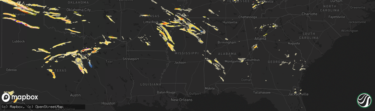
Hail Map in Mississippi on June 11, 2023
The weather event in Mississippi on June 11, 2023 includes Hail, Wind, and Tornado maps. 23 states and 920 cities were impacted and suffered possible damage. The total estimated number of properties impacted is 58,539.
Hail
Wind
Tornado
58,539
Estimated number of impacted properties by a 1.00" hail or larger17,111
Estimated number of impacted properties by a 1.75" hail or larger0
Estimated number of impacted properties by a 2.50" hail or largerStorm reports in Mississippi
Mississippi
| Date | Description |
|---|---|
| 06/11/20236:48 PM CDT | Quarter size hail at getwell road and byhalia road and malone road and byhalia road. |
| 06/11/20236:48 PM CDT | Golfball size hail fell at the panola county medical center. |
| 06/11/20236:47 PM CDT | Quarter size hail fell south of sarah. |
| 06/11/20236:45 PM CDT | Quarter size hail just south of batesville. |
| 06/11/20236:10 PM CDT | A utility pole and some power lines were knocked down along old highway 4. |
| 06/11/20235:50 PM CDT | Golf ball sized hail fell at highway 51 and nail road. |
| 06/11/20235:46 PM CDT | Egg sized hail fell in horn lake. |
| 06/11/20235:35 PM CDT | A local report indicates 1.00 inch wind near 1 NNW Walls |
| 06/11/20235:35 PM CDT | Corrects previous hail report from 1 nnw walls. Quarter size hail at goodman road and delta bluffs parkway. |
| 06/11/20235:35 PM CDT | A local report indicates 1.25 inch wind near 2 N Walls |
| 06/11/202310:54 AM CDT | Washington county so reported damage at the holiday inn and trees down near greenville. |
| 06/10/202310:54 PM CDT | Corrects previous tstm wnd dmg report from 3 ese greenville. Washington county so reported damage at the holiday inn and trees down near greenville. |
| 06/10/202310:54 PM CDT | Washington county so reported a few trees down along wilmont rd. |
| 06/10/202310:32 PM CDT | Lowndes county so reported multiple trees and power lines down near the 10 block of schlater rd. |
| 06/10/202310:24 PM CDT | Mping reports wind damage similar to tree limbs broken and shingles blown off near token rd. |
| 06/10/202310:22 PM CDT | Mping reports wind damage similar to tree limbs broken and shingles blown off near starkville. |
| 06/10/202310:12 PM CDT | Tree is down in the roadway on earnest jones dr. |
| 06/10/202310:12 PM CDT | Corrects previous tstm wnd dmg report from 1 nnw starkville. Large tree limb is down in the roadway on earnest jones dr. |
| 06/10/20239:50 PM CDT | Clay county dispatch reported multiple trees down along natchez trace pkwy. |
| 06/10/20239:45 PM CDT | An uprooted tree destroyed a manufactured home. |
| 06/10/20239:42 PM CDT | Trees down on two vehicles on jackson street. |
| 06/10/20239:40 PM CDT | Trees down across anchor road. Powerlines down. |
| 06/10/20239:38 PM CDT | Tree knocked down across county road 424 west of houston. |
| 06/10/20239:38 PM CDT | Large tree down on a home in the woodland area. |
| 06/10/20239:38 PM CDT | Significant damage to a manufactured home on county road 416. |
| 06/10/20239:30 PM CDT | A local report indicates 1.25 inch wind near 1 SSW Symonds |
| 06/10/20238:39 PM CDT | Significant damage to three greenhouses with minor damage to others on cardsville church road. Roof torn from a house. Tornado debris signature was evident on kgwx 88d |
| 06/10/20238:20 PM CDT | Corrects previous tstm wnd dmg report from 2 e tupelo. Trees and power lines down in central tupelo. One tree on a house with minor injuries. |
| 06/10/20238:18 PM CDT | Spotter reports shutter damage to a home in southwest tupelo. A few large tree branches down. |
| 06/10/20238:18 PM CDT | Quarter size hail fell in the southern part of tupelo. |
| 06/10/20238:05 PM CDT | A local report indicates 1.00 inch wind near Banner |
| 06/10/20237:55 PM CDT | Trees down on county road 268. |
| 06/10/20237:53 PM CDT | A local report indicates 1.25 inch wind near 1 ENE Crenshaw |
| 06/10/20237:51 PM CDT | Quarter size hail reported on highway 61 in tunica. |
| 06/10/20237:41 PM CDT | Quarter size hail fell in ingomar. |
| 06/10/20237:38 PM CDT | Ping pong size hail fell near new albany. |
| 06/10/20237:38 PM CDT | Ping pong size hail fell near new albany. |
| 06/10/20237:36 PM CDT | Quarter size hail fell in the martintown area. |
| 06/10/20237:31 PM CDT | Broken utility pole and downed lines along highway 30 near county road 56 west of new albany. |
| 06/10/20237:25 PM CDT | Quarter size hail fell in the lakes subdivision near oxford. |
| 06/10/20237:21 PM CDT | Tree and powerline down at tate-marshall road at clanton road. |
| 06/10/20237:21 PM CDT | Half dollar size hail fell along highway 349 near cornersville. |
| 06/10/20237:17 PM CDT | Ping pong ball size hail fell at the intersection of highway 331 and highway 334. |
| 06/10/20237:15 PM CDT | A local report indicates 1.75 inch wind near 5 SE Oxford |
| 06/10/20237:05 PM CDT | Trees down in the independence area. Trees down across sycamore road and highway 305 at independence road. |
All States Impacted by Hail Map on June 11, 2023
Cities Impacted by Hail Map on June 11, 2023
- Axtell, NE
- Minden, NE
- Chanute, KS
- Erie, KS
- Galesburg, KS
- Sandersville, GA
- Columbia, SC
- Elgin, SC
- Lugoff, SC
- Quinton, OK
- Red Oak, OK
- Kinta, OK
- Wilburton, OK
- Walsenburg, CO
- Hardaway, AL
- Tuskegee, AL
- Lebanon, TN
- Watertown, TN
- Brush Creek, TN
- Alexandria, TN
- Liberty, KY
- Elk Horn, KY
- Aguilar, CO
- Talihina, OK
- Wister, OK
- Charlotte, TN
- White Bluff, TN
- Ashland City, TN
- Albany, KY
- Baxter, TN
- Bloomington Springs, TN
- Gainesboro, TN
- Cookeville, TN
- Trinidad, CO
- Hustonville, KY
- Middleburg, KY
- Byrdstown, TN
- Monroe, TN
- Pall Mall, TN
- Monticello, KY
- Livingston, TN
- Rickman, TN
- Allred, TN
- Crawford, TN
- Alpine, TN
- Nancy, KY
- Somerset, KY
- Russell Springs, KY
- Ferguson, KY
- Windsor, KY
- Dunnville, KY
- Yosemite, KY
- Nashville, TN
- Madison, TN
- Old Hickory, TN
- Hendersonville, TN
- Jamestown, TN
- Wilder, TN
- Model, CO
- Littleton, CO
- Lone Tree, CO
- Sedalia, CO
- Grantville, GA
- Moreland, GA
- Luthersville, GA
- Castle Rock, CO
- Parker, CO
- Franktown, CO
- Allardt, TN
- Branson, CO
- Trinchera, CO
- Stuttgart, AR
- Hazen, AR
- De Valls Bluff, AR
- Roe, AR
- Sharpsburg, GA
- Newnan, GA
- Senoia, GA
- Clarendon, AR
- Altheimer, AR
- Wabbaseka, AR
- Elizabeth, CO
- Holly Grove, AR
- Crossville, TN
- Crab Orchard, TN
- Rockwood, TN
- Proctor, AR
- Helenwood, TN
- Huntsville, TN
- Wynne, AR
- Walls, MS
- Abilene, TX
- Buffalo Gap, TX
- Tuscola, TX
- Pioneer, TN
- Oneida, TN
- Horn Lake, MS
- Byhalia, MS
- Red Banks, MS
- Trumann, AR
- Marked Tree, AR
- Oakdale, TN
- Wartburg, TN
- Tyronza, AR
- Lepanto, AR
- Brinkley, AR
- Aubrey, AR
- Oliver Springs, TN
- Harriman, TN
- Newcomb, TN
- Morrilton, AR
- La Follette, TN
- Plumerville, AR
- Kim, CO
- Dryden, TX
- Southaven, MS
- Clyde, TX
- Joiner, AR
- Dyess, AR
- Albany, TX
- Greenbrier, AR
- Conway, AR
- Gouldbusk, TX
- Coleman, TX
- Santa Anna, TX
- Lake Cormorant, MS
- Weatherford, TX
- Nesbit, MS
- Tipp City, OH
- De Witt, AR
- Gillett, AR
- Kings Mountain, KY
- Waynesburg, KY
- Statesboro, GA
- Metter, GA
- Register, GA
- Springfield, TN
- White House, TN
- Cherry Valley, AR
- Hickory Ridge, AR
- Stanton, TN
- Hogansville, GA
- Lagrange, GA
- Carthage, TN
- Louviers, CO
- Flippin, AR
- Lake George, CO
- Lyons, GA
- Swainsboro, GA
- Midville, GA
- Crane, MO
- Marionville, MO
- Billings, MO
- Dixon Springs, TN
- Riddleton, TN
- Hartsville, TN
- Fort Stockton, TX
- Greensburg, KY
- Campbellsville, KY
- Pleasant Shade, TN
- Guyton, GA
- Rocky Ford, GA
- Millen, GA
- Sylvania, GA
- Crab Orchard, KY
- Newport, AR
- Bradford, AR
- Hestand, KY
- Tompkinsville, KY
- Sparta, TN
- Humphrey, AR
- Marion, AR
- Ovalo, TX
- Jamestown, KY
- Garnett, SC
- Pineland, SC
- Moss, TN
- Whitleyville, TN
- Celina, TN
- Gay, GA
- Callahan, FL
- Beedeville, AR
- McCrory, AR
- Castalian Springs, TN
- Bethpage, TN
- Memphis, TN
- Olive Branch, MS
- Bloomingdale, GA
- Mount Juliet, TN
- Gallatin, TN
- Brigham City, UT
- Englewood, CO
- Dickson, TN
- Robbins, TN
- Headland, AL
- Brodhead, KY
- Hardyville, KY
- Knifley, KY
- Columbia, KY
- Dardanelle, AR
- Woodbury, TN
- Monterey, TN
- Milton, TN
- Lascassas, TN
- Allons, TN
- Valera, TX
- Hilham, TN
- Red Boiling Springs, TN
- Lafayette, TN
- Burkesville, KY
- Heth, AR
- Midway, GA
- Hilliard, FL
- Edmonton, KY
- Portland, TN
- Spring City, TN
- Mccurtain, OK
- Whitesboro, OK
- Notasulga, AL
- Auburn, AL
- Hermitage, TN
- Pegram, TN
- Norton, TX
- Mount Vernon, KY
- Cobbtown, GA
- Buffalo Valley, TN
- Ulm, AR
- Carlisle, AR
- Crawfordsville, AR
- Estill, SC
- Tillman, SC
- Parkin, AR
- Hickman, TN
- Gordonsville, TN
- Hobe Sound, FL
- Mason, TN
- Grenville, NM
- Folsom, NM
- Gould, AR
- Sunbright, TN
- Watson, AR
- Tichnor, AR
- Evensville, TN
- Hernando, MS
- Lenoir City, TN
- Knoxville, TN
- Farragut, TN
- Rochelle, TX
- Clinton, TN
- Briceville, TN
- Michie, TN
- Counce, TN
- Coldwater, MS
- Boise, ID
- Courtland, MS
- Batesville, MS
- Fort Worth, TX
- Azle, TX
- Oxford, MS
- Rohwer, AR
- Benoit, MS
- Merkel, TX
- Hawley, TX
- Almyra, AR
- Hereford, TX
- Adrian, TX
- Taylor, MS
- Potts Camp, MS
- Myrtle, MS
- Water Valley, MS
- Marianna, AR
- Rockwall, TX
- Royse City, TX
- Tunica, MS
- New Albany, MS
- Pontotoc, MS
- Roanoke, TX
- Ecru, MS
- Blue Springs, MS
- Southlake, TX
- Flower Mound, TX
- Anson, TX
- Lueders, TX
- Boise City, OK
- Kenton, OK
- Thaxton, MS
- Randolph, MS
- Moran, TX
- Breckenridge, TX
- Ethel, AR
- Snow Lake, AR
- Gunnison, MS
- Belden, MS
- Cisco, TX
- Lohn, TX
- Naval Air Station Jrb, TX
- Tupelo, MS
- Argyle, TX
- Lewisville, TX
- Toccoa, GA
- Eastanollee, GA
- Cranks, KY
- Pennington Gap, VA
- Rosedale, MS
- Merigold, MS
- Mound Bayou, MS
- Vega, TX
- Wildorado, TX
- Dallas, TX
- Canyon, TX
- Happy, TX
- Banner, MS
- Bruce, MS
- Granbury, TX
- Godley, TX
- Cleburne, TX
- Capulin, NM
- Des Moines, NM
- Raton, NM
- Strawn, TX
- Graford, TX
- Palo Pinto, TX
- Lake Dallas, TX
- Beulah, MS
- The Colony, TX
- Carrollton, TX
- Plano, TX
- Jasper, GA
- Marble Hill, GA
- Dawsonville, GA
- Frisco, TX
- Grandview, TX
- Rio Vista, TX
- Mineral Wells, TX
- Allen, TX
- Covington, TX
- Mckinney, TX
- Ennis, TX
- Waxahachie, TX
- Keyes, OK
- Amarillo, TX
- Tulia, TX
- Perrin, TX
- Joshua, TX
- Crowley, TX
- Silverton, TX
- Barry, TX
- Italy, TX
- Blooming Grove, TX
- Corsicana, TX
- Poolville, TX
- Clayton, NM
- Springtown, TX
- Agate, CO
- Limon, CO
- Matheson, CO
- Burleson, TX
- Purdon, TX
- Texhoma, OK
- Goodwell, OK
- Cleveland, MS
- Boyle, MS
- Shaw, MS
- Indianola, MS
- Clarendon, TX
- Quitaque, TX
- Boyd, TX
- Paradise, TX
- Tolar, TX
- Rhome, TX
- Glen Rose, TX
- Moorhead, MS
- Greenville, TX
- Honey Grove, TX
- Ladonia, TX
- Roxton, TX
- Caddo Mills, TX
- Pecan Gap, TX
- Paris, TX
- Pattonville, TX
- Rainbow, TX
- Aquilla, TX
- Abbott, TX
- West, TX
- Deport, TX
- Lake Creek, TX
- Penelope, TX
- Mount Calm, TX
- Sulphur Bluff, TX
- Cooper, TX
- Childress, TX
- Turkey, TX
- Felt, OK
- Clarksville, TX
- Idabel, OK
- Haworth, OK
- Blum, TX
- Kopperl, TX
- Axtell, TX
- Hubbard, TX
- Bogata, TX
- Miami, NM
- Springer, NM
- Greenville, MS
- Leland, MS
- Mart, TX
- Dalhart, TX
- Whitney, TX
- Tell, TX
- Stratford, TX
- Morgan, TX
- Clifton, TX
- Valley Mills, TX
- Aspermont, TX
- Hollandale, MS
- Waco, TX
- China Spring, TX
- Anguilla, MS
- Belzoni, MS
- Louise, MS
- Hampton, AR
- Sarah, MS
- Crenshaw, MS
- Kiowa, CO
- Winfield, TN
- Sparkman, AR
- Camden, AR
- McRae Helena, GA
- Glenwood, GA
- Sledge, MS
- Dacula, GA
- Maxwell, NM
- Covington, TN
- Riverside, OR
- Springfield, GA
- Haleyville, AL
- Phil Campbell, AL
- Waynesboro, TN
- Clifton, TN
- Bath Springs, TN
- Bronston, KY
- Colt, AR
- Howard, CO
- Claxton, GA
- Millsap, TX
- Senatobia, MS
- Como, MS
- Sardis, MS
- Lawrenceville, GA
- Loxahatchee, FL
- Blossom, TX
- Detroit, TX
- Kingston, TN
- Pritchett, CO
- Mesquite, TX
- Princeton, TX
- Milliken, CO
- Ranger, TX
- Rienzi, MS
- Gordon, TX
- Baird, TX
- Caddo, TX
- Jacksonville, FL
- Richmond Hill, GA
- Guffey, CO
- Kingston Springs, TN
- Fairview, TN
- Augusta, AR
- Gurdon, AR
- Rowlett, TX
- Lula, GA
- Alto, GA
- Cornelia, GA
- Coppell, TX
- Washington, AR
- Columbus, AR
- Fulton, AR
- Wylie, TX
- Quinlan, TX
- Nevada, TX
- Rosie, AR
- Oil Trough, AR
- Thida, AR
- Magness, AR
- Fernandina Beach, FL
- Newville, AL
- Abbeville, AL
- Columbia, AL
- Ten Mile, TN
- Dayton, TN
- Ball Ground, GA
- Moro, AR
- Palestine, AR
- Talpa, TX
- Decaturville, TN
- Bairoil, WY
- Simla, CO
- Philadelphia, TN
- Loudon, TN
- Houlka, MS
- Houston, MS
- Fleming, GA
- Cotopaxi, CO
- Dundee, MS
- Holly Springs, MS
- Grapevine, TX
- Russellville, AL
- Helena, AR
- Marvell, AR
- Lexa, AR
- Poplar Grove, AR
- Cordova, TN
- Ramah, CO
- Lawrenceburg, TN
- Summertown, TN
- Ethridge, TN
- Belmont, MS
- Foreman, AR
- Ashdown, AR
- Palmer, TX
- Townville, SC
- Norcross, GA
- Lilburn, GA
- Dahlonega, GA
- Waterford, MS
- Garland, TX
- Baldwin, GA
- Tishomingo, MS
- Cherokee, AL
- Greenville, GA
- Keller, TX
- Cumming, GA
- Jellico, TN
- Duff, TN
- Drummonds, TN
- Rocky Top, TN
- Rockwood, TX
- Paris, ID
- Little Elm, TX
- Chidester, AR
- Twin Falls, ID
- Delta, UT
- Bard, NM
- Munford, TN
- Atoka, TN
- Bagwell, TX
- Red Oak, TX
- Grand Prairie, TX
- Irving, TX
- Mountain View, AR
- Dennis, MS
- Red Bay, AL
- Hickory Flat, MS
- Blue Mountain, MS
- Brighton, TN
- Lancing, TN
- Glennville, GA
- Aurora, CO
- Tarrytown, GA
- Vidalia, GA
- Dumas, AR
- Murrayville, GA
- Cleveland, GA
- Saltillo, MS
- Mantachie, MS
- Mooreville, MS
- Osceola, AR
- Etowah, AR
- Etta, MS
- Abbeville, MS
- Paris, MS
- Rising Star, TX
- Peachtree City, GA
- Sumner, TX
- Arlington, TX
- Mansfield, TX
- Cedar Hill, TX
- Midlothian, TX
- Spruce Pine, AL
- Iuka, MS
- Bearden, AR
- Alamo, GA
- Fairmount, GA
- Rydal, GA
- Cascade, ID
- West Helena, AR
- Oak Ridge, TN
- Melbourne, AR
- Batesville, AR
- Fifty Six, AR
- Pleasant Grove, AR
- Clarkesville, GA
- Demorest, GA
- Tillar, AR
- England, AR
- Lonoke, AR
- Franklin, TN
- Farmersville, TX
- Westpoint, TN
- Niota, TN
- Decatur, TN
- Bluff City, AR
- Prescott, AR
- Powell, TN
- Heiskell, TN
- Earle, AR
- Kingsland, AR
- Sunnyvale, TX
- Bloomington, ID
- Guys, TN
- Winthrop, AR
- Grimsley, TN
- Guntown, MS
- Weston, CO
- Savannah, GA
- Pooler, GA
- Waterloo, AL
- Hinesville, GA
- Mount Airy, GA
- Mount Vernon, GA
- Soperton, GA
- Brickeys, AR
- Robinsonville, MS
- Booneville, MS
- Corinth, MS
- Okolona, MS
- Williamsburg, KY
- Cresson, TX
- Wingate, TX
- Winters, TX
- Bunnell, FL
- Nettleton, MS
- Canon City, CO
- Elmwood, TN
- Auburntown, TN
- Screven, GA
- Sachse, TX
- Lavon, TX
- Grandview, TN
- Boswell, OK
- Vardaman, MS
- Pittsboro, MS
- Lancaster, TX
- Tate, GA
- Marks, MS
- Newark, TX
- Germantown, TN
- Eads, TN
- Collierville, TN
- Bryceville, FL
- Andersonville, TN
- Thornton, AR
- Arthur City, TX
- Plantersville, MS
- Fulton, MS
- Shannon, MS
- Smithville, MS
- Amory, MS
- Corinne, UT
- Frenchmans Bayou, AR
- Bassett, AR
- Williamson, GA
- Brooks, GA
- Haslet, TX
- Widener, AR
- Hughes, AR
- Aledo, TX
- Dowelltown, TN
- Liberty, TN
- Ramer, TN
- Ludowici, GA
- Hugo, OK
- Venus, TX
- Kennedale, TX
- Alvarado, TX
- Old Glory, TX
- Elm Mott, TX
- Gruver, TX
- Texhoma, TX
- Rule, TX
- Stamford, TX
- Arkansas City, AR
- Gladstone, NM
- Inverness, MS
- Isola, MS
- Avoca, TX
- Demopolis, AL
- Sedan, NM
- Throckmorton, TX
- Texline, TX
- Mosquero, NM
- Nara Visa, NM
- Amistad, NM
- Hartley, TX
- Channing, TX
- Logan, NM
- Newcastle, TX
- Olney, TX
- Holliday, TX
- Ocate, NM
- Wagon Mound, NM
- Windthorst, TX
- Grady, AR
- Tellico Plains, TN
- Johnstown, CO
- Snellville, GA
- Grayson, GA
- Juntura, OR
- West Point, MS
- Prairie, MS
- Westminster, SC
- Union Point, GA
- Tuttle, OK
- Blanchard, OK
- Newcastle, OK
- Starkville, MS
- Cedarbluff, MS
- Columbus, MS
- Campbell, TX
- Snyder, TX
- Keiser, AR
- Ben Franklin, TX
- Nemo, TX
- Gardendale, AL
- Pope, MS
- Loretto, TN
- Deatsville, AL
- Marbury, AL
- McGehee, AR
- Martin, GA
- Oxford, AL
- Munford, AL
- Rincon, GA
- Hillsboro, TX
- Double Springs, AL
- Keene, TX
- Twain, CA
- Quincy, CA
- Guion, AR
- Calico Rock, AR
- Mount Pleasant, AR
- Eutaw, AL
- Boligee, AL
- De Kalb, MS
- Scooba, MS
- Pinson, AL
- Birmingham, AL
- Morris, AL
- Warrior, AL
- Mount Olive, AL
- Itasca, TX
- Mora, NM
- Cimarron, NM
- Norfork, AR
- Fair Play, SC
- Macon, MS
- Canton, GA
- Rotan, TX
- York, AL
- Cuba, AL
- Central, SC
- Anderson, SC
- Pendleton, SC
- Liberty, SC
- Clemson, SC
- Faunsdale, AL
- Woodland, MS
- Verbena, AL
- Jayton, TX
- Hugo, CO
- Houston, AL
- Pine Apple, AL
- Porterville, MS
- Casscoe, AR
- Aliceville, AL
- New Market, AL
- Carnesville, GA
- Tuskegee Institute, AL
- Louisville, GA
- Seneca, SC
- Lillian, TX
- Wayside, TX
- Trenton, TX
- Whitewright, TX
- Norman, OK
- Washington, OK
- Noble, OK
- Lexington, OK
- Mustang, OK
- Oklahoma City, OK
- Roy, NM
- Dumas, TX
- Sunray, TX
- Stinnett, TX
- Panhandle, TX
- Fritch, TX
- Masterson, TX
- Skellytown, TX
- Borger, TX
- Pampa, TX
- White Deer, TX
- Groom, TX
- Sayre, OK
- Carter, OK
- Elk City, OK
- Dill City, OK
- Canute, OK
- Hobart, OK
- Gotebo, OK
- Roosevelt, OK
- Mountain View, OK
- Carnegie, OK
- Hammon, OK
- Butler, OK
- Foss, OK
- Paoli, OK
- Pauls Valley, OK
- Stratford, OK
- Apache, OK
- Sentinel, OK
- Cordell, OK
- Clinton, OK
- Mclean, TX
- Lawton, OK
- Elgin, OK
- Shamrock, TX
- Fletcher, OK
- Rush Springs, OK
- Marlow, OK
- Erick, OK
- Temple, OK
- Walters, OK
- Comanche, OK
- Waurika, OK
- Ringling, OK
- Ryan, OK
- Verona, MS
- Science Hill, KY
- Norris, TN
- Maynardville, TN
- Cheyenne, OK
- Rainsville, NM
- Adrian, GA
- Kite, GA
- Wrightsville, GA
- Willow, OK
- Fitzhugh, OK
- Ada, OK
- Henrietta, TX
- Bellevue, TX
- Castleberry, AL
- Brewton, AL
- Fort Sill, OK
- Uniontown, AL
- Thomaston, AL
- Safford, AL
- Catherine, AL
- Purcell, OK
- Lone Wolf, OK
- Granite, OK
- Cyril, OK
- Newbern, AL
- Cement, OK
- Lindsay, OK
- Meigs, GA
- Sale City, GA
- Hartsfield, GA
- Camden, AL
- Fort Cobb, OK
- Pennington, AL
- Sweet Water, AL
- Linden, AL
- Bellamy, AL
- Livingston, AL
- Reydon, OK
- Annona, TX
- Arlington, AL
- Wilson, OK
- Hastings, OK
- Silver City, MS
- Rocky, OK
- Coy, AL
- Pine Hill, AL
- Hurtsboro, AL
- Hatchechubbee, AL
- Tallassee, AL
- Haskell, TX
- Celeste, TX
- Leonard, TX
- Weatherford, OK
- Arapaho, OK
- Denton, TX
- Shorter, AL
- Georgiana, AL
- Evergreen, AL
- McKenzie, AL
- Magnolia, AL
- Alberta, AL
- Byars, OK
- Wheeler, TX
- Minter, AL
- Gallion, AL
- Orrville, AL
- Pittsview, AL
- Sweetwater, OK
- Auburn, GA
- Anadarko, OK
- Miami, TX
- Canadian, TX
- Range, AL
- Lenox, AL
- Repton, AL
- Briscoe, TX
- Monroeville, AL
- Corn, OK
- Lower Peach Tree, AL
- Texola, OK
- Christiansburg, OH
- Saint Paris, OH
- York, PA


