Hail Map in Mississippi on June 10, 2023
The weather event in Mississippi on June 10, 2023 includes Wind and Hail maps. 20 states and 761 cities were impacted and suffered possible damage. The total estimated number of properties impacted is 574.
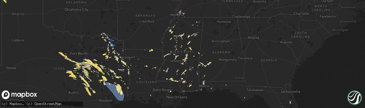
Wind
Hail
574
Estimated number of impacted properties by a 1.00" hail or larger0
Estimated number of impacted properties by a 1.75" hail or larger0
Estimated number of impacted properties by a 2.50" hail or largerStorm reports in Mississippi
Mississippi
| Date | Description |
|---|---|
| 06/10/20236:52 PM CDT | Multiple trees down near hwy 51 and i55. |
| 06/10/20236:42 PM CDT | A tree was blown down into the road near the intersection of ms highway 15 and stratton road. |
| 06/10/20236:30 PM CDT | Tin was blown off a trailer and chicken house. Multiple trees are down in the area near scr 502. |
| 06/10/20236:30 PM CDT | Tree down on the side of the west bound line of hwy 84 between eddiceton and quinton. |
| 06/10/20236:26 PM CDT | A large tree was blown down... And minor damage occurred to a house in the 300 block of county road 812. |
| 06/10/20236:08 PM CDT | Several trees were reported down along with possible damage to a home in the 3000 block of highway 528. |
| 06/10/20236:08 PM CDT | Corrects previous tstm wnd dmg report from 1 ese oak bowery. Several trees were reported down along with possible damage to a home in the 3000 block of highway 528. Som |
| 06/10/20236:08 PM CDT | Corrects previous tstm wnd dmg report from 1 ese oak bowery. Several trees were blown down near the intersection of cr 52830 and ms highway 528... And a home in the 350 |
| 06/10/20236:08 PM CDT | A tree was blown down onto pleasant grove road. |
| 06/10/20236:03 PM CDT | A tree was blown down across and blocked summerland road. |
| 06/10/20235:53 PM CDT | Large oak tree blocking the roadway. |
| 06/10/20235:53 PM CDT | Large oak tree blocking the roadway. (ja |
| 06/10/20235:53 PM CDT | Corrects previous tstm wnd dmg report from 4 nw myrick. Large oak tree blocking reid road near the bethlehem baptist church. |
| 06/10/20235:36 PM CDT | Road sign down at i55 south and lakeland dr. |
| 06/10/20235:25 PM CDT | Lamar county so reported telephone lines hanging down near the street near ralph rawls rd. |
| 06/10/20235:17 PM CDT | Multiple fences blown down and tree damage. |
| 06/10/20235:17 PM CDT | Large tree limbs down near sherbourne dr. |
| 06/10/20235:15 PM CDT | Lamar county so reported several trees and power lines down near caney church rd and prospres ridge rd. |
| 06/10/20235:12 PM CDT | Huge oak tree snapped at the base. |
| 06/10/20235:08 PM CDT | Tree blocking county line rd. |
| 06/10/20235:07 PM CDT | Trees down in parking lot. |
| 06/10/20235:02 PM CDT | 3 inch tree branches down on old canton. |
| 06/10/20235:00 PM CDT | Several full grown trees uprooted. |
| 06/10/20234:52 PM CDT | Large tree on a home near canton mart rd. |
| 06/10/20234:27 PM CDT | A tree was blown down onto kitchner road. |
| 06/10/20234:27 PM CDT | Corrects previous tstm wnd dmg report from 4 e sebastopol. A tree was blown down onto kitchner road... And a tree was blown down near conehatta-prospect road and ms hig |
| 06/10/20234:22 PM CDT | A tree was blown down in the road along the 1400 block of ms highway 492. |
| 06/10/20234:16 PM CDT | A tree was blown down into the road along newton-conehatta road. |
| 06/10/20234:05 PM CDT | Choctaw so reported two large limbs down near hwy 15 and near reform sturgis rd. |
| 06/10/20234:00 PM CDT | Scott county so reported that several trees and power lines were brought down near lake. |
| 06/10/20233:35 PM CDT | Scott county so reported that several trees and power lines were brought down in the community of homewood. |
| 06/10/20231:38 PM CDT | Emergency manager reported multiple trees down in the area of cuevas town road. |
| 06/10/202312:55 PM CDT | Reports of trees down on warner ave and west main st. |
All States Impacted by Hail Map on June 10, 2023
Cities Impacted by Hail Map on June 10, 2023
- Bogata, TX
- Talco, TX
- Mount Pleasant, TX
- Omaha, TX
- Cookville, TX
- Naples, TX
- Clarksville, TX
- Annona, TX
- Avery, TX
- De Kalb, TX
- Blanco, OK
- Edgemont, AR
- Higden, AR
- Hugo, OK
- Boswell, OK
- Antlers, OK
- Soper, OK
- Stringtown, OK
- Pittsburg, OK
- Bagwell, TX
- Detroit, TX
- Paris, TX
- Fairfield Bay, AR
- Scroggins, TX
- Muldrow, OK
- Gilmer, TX
- Tupelo, OK
- Avinger, TX
- Coalgate, OK
- Atoka, OK
- Ore City, TX
- Jefferson, TX
- Lone Star, TX
- Eastpoint, FL
- Daingerfield, TX
- Solgohachia, AR
- Blossom, TX
- Pattonville, TX
- Stonewall, OK
- Pittsburg, TX
- Diana, TX
- Hallsville, TX
- Longview, TX
- Lane, OK
- Marshall, TX
- Mineola, TX
- Powderly, TX
- Atlanta, TX
- Lindale, TX
- Hawkins, TX
- Mount Vernon, TX
- Clinton, AR
- Scotland, AR
- Deport, TX
- Rattan, OK
- Finley, OK
- Shirley, AR
- Leesburg, TX
- Winnsboro, TX
- Quitman, TX
- Seminole, AL
- Bivins, TX
- Rodessa, LA
- Vivian, LA
- Mcalester, OK
- Savanna, OK
- Grant, OK
- Fort Towson, OK
- Haworth, OK
- Idabel, OK
- Broken Bow, OK
- Sulphur Springs, TX
- Louisville, MS
- Usaf Academy, CO
- Colorado Springs, CO
- McIntosh, AL
- Sunflower, AL
- Wagarville, AL
- Saucier, MS
- McHenry, MS
- Perkinston, MS
- Bastrop, LA
- Mabank, TX
- Eustace, TX
- Athens, TX
- Kerens, TX
- Malakoff, TX
- Fountain, CO
- Ennis, TX
- Waxahachie, TX
- Corsicana, TX
- Barry, TX
- Rice, TX
- Chatfield, TX
- Palestine, TX
- Frankston, TX
- Breckenridge, TX
- Caddo, TX
- Powell, TX
- Briggsdale, CO
- Italy, TX
- Penelope, TX
- Hubbard, TX
- Malone, TX
- Blooming Grove, TX
- Strawn, TX
- Midway, TX
- Lovelady, TX
- Clayton, NM
- Grenville, NM
- Fairfield, TX
- Tennessee Colony, TX
- Streetman, TX
- Wautoma, WI
- Wild Rose, WI
- Redgranite, WI
- Montalba, TX
- Oakwood, TX
- Gordon, TX
- Goree, TX
- Throckmorton, TX
- Graham, TX
- Ephraim, UT
- Munday, TX
- Grandview, TX
- Norwood, CO
- Hillsboro, TX
- Itasca, TX
- Weatherford, TX
- Moab, UT
- Rio Vista, TX
- Spring Creek, NV
- Roy, NM
- Nara Visa, NM
- Miami, NM
- Thompson, UT
- Mineral Wells, TX
- Bynum, TX
- Tulia, TX
- Huntington, UT
- Silverton, TX
- Seymour, TX
- Covington, TX
- Santo, TX
- Wildorado, TX
- Paducah, TX
- Happy, TX
- Monticello, UT
- Vega, TX
- Quitaque, TX
- Canyon, TX
- Graford, TX
- Granbury, TX
- Questa, NM
- Nephi, UT
- Eagle Nest, NM
- Lipan, TX
- Vallecitos, NM
- Cleburne, TX
- Palo Pinto, TX
- Millsap, TX
- Matador, TX
- Newcastle, TX
- Godley, TX
- Red River, NM
- Bedrock, CO
- Ophir, CO
- Castle Dale, UT
- Fairview, UT
- Placerville, CO
- Nucla, CO
- Antonito, CO
- Elko, NV
- Creede, CO
- Mosquero, NM
- Logan, NM
- Pagosa Springs, CO
- Wales, UT
- Redvale, CO
- Ferron, UT
- Spring City, UT
- Costilla, NM
- Orangeville, UT
- Adel, OR
- Orovada, NV
- Tuscarora, NV
- Ridgway, CO
- Hereford, TX
- Turkey, TX
- Plush, OR
- Springer, NM
- Moroni, UT
- Paradox, CO
- Ute Park, NM
- Lake City, CO
- Eureka, UT
- Mountain City, NV
- Dugway, UT
- West Wendover, NV
- Paradise Valley, NV
- Fields, OR
- Wells, NV
- Levan, UT
- Telluride, CO
- Paisley, OR
- Carlin, NV
- Amarillo, TX
- Wendover, UT
- Mount Pleasant, UT
- Naturita, CO
- Mills, NM
- Lakeview, OR
- Deeth, NV
- Green River, UT
- Cimarron, NM
- Silverton, CO
- Adrian, TX
- Denio, NV
- Blum, TX
- Wagon Mound, NM
- Flomot, TX
- Manti, UT
- Elkhart, TX
- Huntington, TX
- Etoile, TX
- Zavalla, TX
- Lufkin, TX
- Kennard, TX
- Pollok, TX
- Grapeland, TX
- Boone, CO
- Olney Springs, CO
- Ordway, CO
- Rocky Ford, CO
- Crowley, CO
- Manzanola, CO
- Jonesboro, TX
- Gatesville, TX
- Purmela, TX
- Friars Point, MS
- Clarksdale, MS
- Coahoma, MS
- Annandale, MN
- Burwell, NE
- Memphis, TN
- Ravenna, NE
- Pleasanton, NE
- Minneapolis, MN
- Yerington, NV
- Jasper, TX
- Norwood Young America, MN
- Pulaski, MS
- Raleigh, MS
- Nunn, CO
- Lexington, MS
- Cruger, MS
- Camptonville, CA
- Goodyears Bar, CA
- Morton, MS
- Shelbyville, TX
- Center, TX
- Timpson, TX
- Garrison, TX
- Crossett, AR
- Gladewater, TX
- Arlington, TN
- Lambert, MS
- Tutwiler, MS
- Vance, MS
- Carrollton, MS
- Greenwood, MS
- Pritchett, CO
- Silver Creek, MS
- Philipp, MS
- Charleston, MS
- Big Sandy, TX
- Crenshaw, MS
- Dundee, MS
- Kemp, TX
- Natchez, LA
- Cloutierville, LA
- De Berry, TX
- Carthage, MS
- West, MS
- Vaiden, MS
- Millington, TN
- Meridian, MS
- Collinsville, MS
- Bailey, MS
- Doddsville, MS
- Forest, MS
- Lake, MS
- Litchfield, NE
- Calhoun City, MS
- Winona, TX
- Quitman, MS
- Tyler, TX
- Douglass, TX
- Livingston, AL
- Wiggins, MS
- Broaddus, TX
- Nacogdoches, TX
- Mathiston, MS
- Weir, MS
- Ackerman, MS
- Sunflower, MS
- Ruleville, MS
- Butler, AL
- Lisman, AL
- Olla, LA
- Young America, MN
- Scooba, MS
- Larue, TX
- Tchula, MS
- Cascilla, MS
- Holcomb, MS
- Mayer, MN
- Waverly, MN
- Howard Lake, MN
- Montrose, MN
- New Germany, MN
- Winsted, MN
- Noble, LA
- Zwolle, LA
- Converse, LA
- Minter City, MS
- Newhebron, MS
- Walnut Grove, MS
- Conehatta, MS
- Philadelphia, MS
- Sebastopol, MS
- Union, MS
- Palatka, FL
- Madisonville, TX
- Reddick, FL
- Atoka, TN
- Harleton, TX
- Maben, MS
- Youngsville, LA
- Shubuta, MS
- Tatum, TX
- Beckville, TX
- Carthage, TX
- Lyon, MS
- Wheeler, WI
- Mansfield, LA
- Keithville, LA
- Logansport, LA
- Keatchie, LA
- Grand Cane, LA
- Gloster, LA
- Carr, CO
- Waskom, TX
- De Kalb, MS
- Satsuma, AL
- Saraland, AL
- Rolling Fork, MS
- Stennis Space Center, MS
- Alto, TX
- Union Church, MS
- Lumberton, MS
- Pelican, LA
- Eads, TN
- Somerville, TN
- Oakland, TN
- Parkdale, AR
- Woodland Park, CO
- Satsuma, FL
- East Palatka, FL
- Columbia, MS
- Robertsdale, AL
- Many, LA
- Como, TX
- Wilmot, AR
- Trinidad, TX
- Cologne, MN
- Wells, TX
- Rossville, TN
- Spearsville, LA
- Grenada, MS
- Madison, FL
- Greenville, FL
- Karnack, TX
- Henderson, TX
- South Haven, MN
- Clearwater, MN
- Coldwater, MS
- Milford, TX
- Gloster, MS
- Crestview, FL
- Defuniak Springs, FL
- Hazard, NE
- Marion, LA
- Midlothian, TX
- Valley Park, MS
- Vicksburg, MS
- Creola, AL
- Eudora, AR
- Pattison, MS
- Joaquin, TX
- Mayersville, MS
- Yazoo City, MS
- Monticello, MS
- Sledge, MS
- Duck Hill, MS
- Coushatta, LA
- Gary, TX
- Simsboro, LA
- Quitman, LA
- Elm Grove, LA
- Pleasant Hill, LA
- Winfield, TX
- Colfax, WI
- Cushing, TX
- Chunchula, AL
- Eight Mile, AL
- Mobile, AL
- Mount Vernon, AL
- Axis, AL
- Campti, LA
- Pierce, CO
- Ault, CO
- Abbott, TX
- Glen Rose, TX
- Rainbow, TX
- Crockett, TX
- Texline, TX
- Sugar City, CO
- La Junta, CO
- Swink, CO
- Avondale, CO
- Rye, CO
- Wilsonville, NE
- Hendley, NE
- Minden, NE
- Axtell, NE
- Hillister, TX
- Warren, TX
- Fort Hood, TX
- Groesbeck, TX
- Mart, TX
- Groveton, TX
- Trinity, TX
- Dalhart, TX
- Fred, TX
- Silsbee, TX
- Kountze, TX
- Lumberton, TX
- Thornton, TX
- Lott, TX
- Rosebud, TX
- Beaumont, TX
- Cameron, TX
- Burlington, TX
- Calvert, TX
- Hartley, TX
- Gause, TX
- Milano, TX
- Caldwell, TX
- Buna, TX
- Sour Lake, TX
- Vidor, TX
- Nederland, TX
- Orange, TX
- Model, CO
- College Station, TX
- Hearne, TX
- Iola, TX
- Bryan, TX
- Franklin, TX
- Anderson, TX
- Navasota, TX
- Brenham, TX
- Washington, TX
- Somerville, TX
- Winona, KS
- Leoti, KS
- Wallace, KS
- Oakley, KS
- Scott City, KS
- Grinnell, KS
- Monument, KS
- Colby, KS
- Levant, KS
- Rexford, KS
- Gem, KS
- Trinidad, CO
- Kim, CO
- Burton, TX
- Ledbetter, TX
- Erie, KS
- Galesburg, KS
- Chanute, KS
- Scotia, NE
- North Loup, NE
- Hayes Center, NE
- Benton, MS
- Brandon, MS
- Louisville, NE
- Springfield, NE
- Bentonia, MS
- Champion, NE
- Ericson, NE
- Hildreth, NE
- Wiggins, CO
- Fort Morgan, CO
- Clearwater, NE
- Richland, TX
- Akron, CO
- Woodrow, CO
- Alton, KS
- Morgan, TX
- Clifton, TX
- Byers, CO
- Purvis, MS
- Thomaston, AL
- Arlington, AL
- Kosse, TX
- Oakdale, NE
- Tilden, NE
- Neligh, NE
- Wilcox, NE
- McGregor, TX
- Crawford, TX
- Kosciusko, MS
- Thomasville, AL
- Campbell, AL
- Amory, MS
- Nemo, TX
- Shingletown, CA
- Poplarville, MS
- Laurel, MS
- Heidelberg, MS
- Magnolia, AL
- Sweet Water, AL
- Dixons Mills, AL
- Catherine, AL
- Pine Hill, AL
- Huntsville, TX
- Magnolia, MS
- Mccomb, MS
- Bienville, LA
- Belton, TX
- Alma, NE
- Palisade, NE
- Wauneta, NE
- Kirbyville, TX
- Franklinton, LA
- Whitney, TX
- Axtell, TX
- Mount Calm, TX
- Coffeeville, MS
- Mertens, TX
- Mexia, TX
- Teague, TX
- Comstock, TX
- Canton, MS
- Madison, MS
- Tougaloo, MS
- Ridgeland, MS
- Jackson, MS
- Onalaska, TX
- Livingston, TX
- Seminary, MS
- Sumrall, MS
- Collins, MS
- Kopperl, TX
- Deer Trail, CO
- Merryville, LA
- Purdon, TX
- Mantee, MS
- Vardaman, MS
- Woodland, MS
- Donie, TX
- Houston, MS
- Harrisonburg, LA
- Sieper, LA
- Hineston, LA
- Centerville, TX
- Hollywood, FL
- Pembroke Pines, FL
- Stephenville, TX
- Tolar, TX
- Bluff Dale, TX
- Saint Francis, KS
- Osyka, MS
- Frost, TX
- Springfield, LA
- Buffalo, TX
- Booneville, MS
- Dawson, TX
- Toxey, AL
- Sandy Hook, MS
- Ellisville, MS
- Diboll, TX
- Needham, AL
- Mingus, TX
- Otis, CO
- Valley Mills, TX
- Woodville, TX
- Taylorsville, MS
- Soso, MS
- Prairie Hill, TX
- Meadville, MS
- Fayette, MS
- Natchez, MS
- Orchard, CO
- Rusk, TX
- Wortham, TX
- Glade, KS
- Phillipsburg, KS
- Tylertown, MS
- Sedan, NM
- Evant, TX
- Hamilton, TX
- Copperas Cove, TX
- Cedar Creek, NE
- Meridian, TX
- Mount Hermon, LA
- Angie, LA
- Republican City, NE
- Naponee, NE
- Saint Cloud, FL
- Farwell, NE
- Ethel, MS
- Oglesby, TX
- Moody, TX
- Cheyenne, WY
- Haines City, FL
- Dundee, FL
- Aberdeen, MS
- Nettleton, MS
- Krum, TX
- Coolidge, TX
- Liberty, MS
- Spurger, TX
- Waco, TX
- Bassfield, MS
- Okolona, MS
- Lorena, TX
- Scobey, MS
- Waynesboro, MS
- Buckatunna, MS
- Riesel, TX
- Marlin, TX
- Louin, MS
- Guntown, MS
- New Albany, MS
- Orlando, FL
- Ponchatoula, LA
- Castle Rock, CO
- Parker, CO
- Chilton, TX
- Eddy, TX
- Bruceville, TX
- Sicily Island, LA
- Kelly, LA
- Brush, CO
- Baldwyn, MS
- Jachin, AL
- McCall Creek, MS
- Greenwood, LA
- Bethany, LA
- Maurepas, LA
- Moscow, TX
- Chester, TX
- Corrigan, TX
- China Spring, TX
- Aquilla, TX
- Prentiss, MS
- Linden, AL
- Bremond, TX
- Reagan, TX
- Okeechobee, FL
- Kissimmee, FL
- West, TX
- Elm Mott, TX
- Jacksonville, TX
- Rienzi, MS
- Lampasas, TX
- Ranger, TX
- Goodrich, TX
- Batson, TX
- Saratoga, TX
- Hull, TX
- Pointblank, TX
- Cleveland, TX
- Coldspring, TX
- Liberty, TX
- Shepherd, TX
- Oakhurst, TX
- Port Neches, TX
- Port Arthur, TX
- Winnie, TX
- Hamshire, TX
- China, TX
- Nome, TX
- Devers, TX
- Oswego, KS
- Parsons, KS
- Columbus, KS
- Pascagoula, MS
- Plainville, KS
- Stockton, KS
- Woodston, KS
- Natoma, KS
- Chappell Hill, TX
- Arlington, KS
- Abbyville, KS
- Plevna, KS
- Arapahoe, CO
- Weskan, KS
- Bleiblerville, TX
- Springfield, CO
- Dighton, KS
- Beeler, KS
- Arthur City, TX
- Ellinwood, KS
- Great Bend, KS
- Hudson, KS
- Paradise, KS
- Noxapater, MS
- Woodway, TX
- Hoisington, KS
- San Mateo, FL
- Kit Carson, CO
- Waldo, KS
- Osborne, KS
- Pretty Prairie, KS
- Murdock, KS
- Kingman, KS
- State Line, MS
- Sylvia, KS
- Olmitz, KS
- Irvington, AL
- Grand Bay, AL
- Bayou La Batre, AL
- Russell, KS
- Gorham, KS
- Thayer, KS
- Ramah, CO
- Manter, KS
- Benedict, KS
- McCune, KS
- Campo, CO
- Clayton, LA
- Rockdale, TX
- Wright City, OK
- Offerle, KS
- Eureka Springs, AR
- Berryville, AR
- Wyandotte, OK
- Grove, OK
- Stella, MO
- Rocky Comfort, MO
- Powell, MO
- Neosho, MO
- Goodman, MO
- Anderson, MO
- Chetopa, KS
- Pueblo, CO


