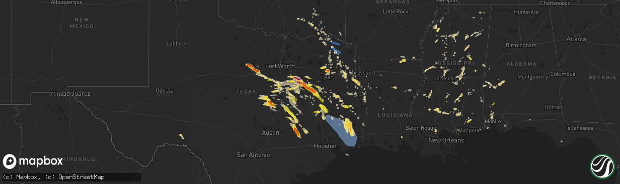
Hail Map on June 10, 2023
The weather event on June 10, 2023 includes Wind and Hail maps. 20 states and 761 cities were impacted and suffered possible damage. The total estimated number of properties impacted is 75,171.
Wind
Hail
75,171
Estimated number of impacted properties by a 1.00" hail or larger20,524
Estimated number of impacted properties by a 1.75" hail or larger5,504
Estimated number of impacted properties by a 2.50" hail or largerStates Impacted by Hail Map on June 10, 2023
Storm reports
Colorado
| Date | Description |
|---|---|
| 06/10/20236:22 PM CDT | A local report indicates 1.00 inch wind near 1 NNE Olney Springs |
| 06/10/20233:31 PM CDT | A local report indicates 1.25 inch wind near 3 SSE Fountain |
| 06/10/20233:10 PM CDT | A local report indicates 1.25 inch wind near 3 SW Security |
| 06/10/20233:10 PM CDT | This corrects the location of hail for 3 sw security report. |
| 06/10/20232:00 PM CDT | A local report indicates 1.50 inch wind near Air Force Academy |
| 06/10/20231:15 PM CDT | A local report indicates 1.00 inch wind near 4 ENE Air Force Academy |
| 06/09/20238:40 PM CDT | Awos station k2v5 2 nw wray. |
Texas
| Date | Description |
|---|---|
| 06/10/20236:59 PM CDT | Penny to quarter size hail reported by trained spotter in fort gates. |
| 06/10/20236:50 PM CDT | Em reports quarter size hail in glen rose. |
| 06/10/20236:50 PM CDT | Several trees reported downed in the community of diboll... Texas. |
| 06/10/20236:45 PM CDT | Trees down in the latexo area. |
| 06/10/20236:36 PM CDT | Trees down in the grapeland area. |
| 06/10/20236:28 PM CDT | A tree was downed blocking one lane of hwy 21 near chireno... Texas. |
| 06/10/20236:28 PM CDT | A tree was downed blocking one la |
| 06/10/20236:20 PM CDT | 3 homes with minor damage and multiple trees down in elkhart. |
| 06/10/20236:00 PM CDT | Report from mping: quarter |
| 06/10/20235:55 PM CDT | Palestine asos measured 55 kt wind gust. |
| 06/10/20235:44 PM CDT | Corsicana asos measured 50 kt wind gust. |
| 06/10/20235:42 PM CDT | Video of golf ball sized hail ne of gordon |
| 06/10/20235:30 PM CDT | A tree was reported downed in the city of rusk... Texas. |
| 06/10/20235:25 PM CDT | Report of quarter |
| 06/10/20234:50 PM CDT | 67 mph wind gust measured 5 miles e of eureka... Tx. |
| 06/10/20234:49 PM CDT | Report of quarter |
| 06/10/20234:22 PM CDT | Golf ball to hen egg sized hail reported in corsicana. |
| 06/10/20234:11 PM CDT | Em reported quarter size hail 1 w of corsicana. |
| 06/10/20234:03 PM CDT | Public report of ping pong ball |
| 06/10/20233:56 PM CDT | Video of quarter and half dollar sized hail on social media se of waxahachie... Tx. |
| 06/10/20233:43 PM CDT | Report from mping: quarter |
| 06/10/20232:56 PM CDT | Quarter size hail reported 1/4 mi w of eustace high school by a trained spotter. |
| 06/10/20232:55 PM CDT | Trees on powerlines reported along highway 87 south. |
| 06/10/20232:30 PM CDT | Report of a tree down on a residence. |
| 06/10/20231:52 PM CDT | Reports of trees and powerlines down throughout the area. |
| 06/10/20231:30 PM CDT | Reports of numerous trees down in the lake cherokee area off of fm 1716. |
| 06/10/20231:30 PM CDT | Reports of numerous trees down in the tatum area. |
| 06/10/20231:30 PM CDT | Reports of trees down in the area. One report of a tree on a powerline near county road 2164. |
| 06/10/20231:10 PM CDT | Reports of trees down throughout the county. |
| 06/10/20231:00 PM CDT | Reports of quarter to golf ball sized hail in hawkins. |
| 06/10/202312:15 PM CDT | Report of trees down along farm to market rd 995. |
| 06/10/202312:08 PM CDT | A report of quarter sized hail was submitted near lake brenda. |
| 06/10/202311:20 AM CDT | Report of trees down along county road 3350. |
| 06/10/202311:20 AM CDT | Report of a powerline down in the 1900 block of mt pleasant. |
| 06/10/202311:15 AM CDT | Reports of multiple trees down across the county. |
| 06/10/202311:11 AM CDT | Report of trees down along pace st in naples... Tx. |
| 06/10/202310:10 AM CDT | Reports of damage to the sonic in town via social media. |
| 06/10/20239:55 AM CDT | Report via social media. |
| 06/09/202311:30 PM CDT | Trees down across the western part of washington county. |
| 06/09/202311:00 PM CDT | Quarter to golf ball size hail was observed. |
| 06/09/202311:00 PM CDT | A local report indicates 1.75 inch wind near 8 WNW Somerville |
| 06/09/202310:50 PM CDT | Hail up to quarter size in washington. |
| 06/09/202310:50 PM CDT | A local report indicates 1.00 inch wind near 7 SW Caldwell |
| 06/09/202310:18 PM CDT | Mesonet station xcrb crab lake. |
| 06/09/202310:13 PM CDT | Wind gust at crab lake weatherflow site. |
| 06/09/202310:13 PM CDT | Mesonet station xlev levee. |
| 06/09/202310:00 PM CDT | Light pole blown down on carlisle court. |
| 06/09/20239:51 PM CDT | Wind gust at kyle field. |
| 06/09/20239:25 PM CDT | Wind gust observed at westward lake lane. |
| 06/09/20239:24 PM CDT | Report from mping: quarter |
| 06/09/20239:09 PM CDT | Wind gust at kiah. |
| 06/09/20239:08 PM CDT | Trees blown down. |
| 06/09/20238:34 PM CDT | Flipped 18 wheeler... 15 inch tree snapped... And camper trailer blown 35-40 ft. Ktxroseb15 personal weather station recorded 79 mph wind speed. |
| 06/09/20238:30 PM CDT | Kbmt reports a measured wind gust of 82 mph at lumberton middle school. |
| 06/09/20238:28 PM CDT | Damage in and around rosebud. Dairy queen on hwy 77 had roof/window damage. More window damage around center of town. |
| 06/09/20238:15 PM CDT | Time estimated based on radar. |
| 06/09/20238:15 PM CDT | Mesonet station fw9014 livingston. |
| 06/09/20238:11 PM CDT | Report of measured gust of 78 mph near durango... Tx. |
| 06/09/20237:58 PM CDT | Trained spotter reports quarter hail e of mart... Tx. |
| 06/09/20237:51 PM CDT | Social media pictures from media of rv flipped and damaged and trees near bruceville-eddy. |
| 06/09/20237:50 PM CDT | Tree down onto a home. |
| 06/09/20237:36 PM CDT | 61 kt wind gusts measured at ft hood aaf/killeen...tx |
| 06/09/20237:10 PM CDT | Golf ball size hail reported in gatesville. |
| 06/09/20237:08 PM CDT | Reports of ping pong ball |
| 06/09/20237:03 PM CDT | Waco...tx |
Arkansas
| Date | Description |
|---|---|
| 06/10/20231:56 PM CDT | Tree limbs blown down near graceland drive and highland avenue in newport. |
| 06/10/20231:28 PM CDT | Tree limbs blown down around searcy. |
| 06/10/202311:00 AM CDT | Report of powerlines and trees down along i-70 west. |
Minnesota
| Date | Description |
|---|---|
| 06/10/20233:19 PM CDT | Mesonet station fw4584 winsted. |
| 06/10/20233:15 PM CDT | Numerous large limbs down in the city of winsted with 2 roads blocked by downed trees. |
| 06/10/20233:15 PM CDT | Several large tree limbs down. Hay field flattened. Beans shredded. Other crops also destroyed by combination of hail and damaging wind. |
| 06/10/20233:15 PM CDT | Hail was mostly dime to nickel size... But some were as large as quarters. Hail accumulated in small drifts. |
| 06/10/20233:05 PM CDT | Numerous trees and power lines down. |
Oklahoma
| Date | Description |
|---|---|
| 06/10/202310:35 AM CDT | Report of a tree down on highway 3 in near tom. |
Louisiana
| Date | Description |
|---|---|
| 06/10/20235:15 PM CDT | Report of a downed tree and powerline in ball... La at the intersection of ball loop and cline dr. A second tree is down on leah dr. Parts of the city are without power |
| 06/10/20234:55 PM CDT | Reports of several trees and powerlines down throughout lasalle parish. |
| 06/10/20234:50 PM CDT | Reports of several trees down across caldwell parish. |
| 06/10/20234:35 PM CDT | Reports of multiple trees and powerlines down throughout grant parish. |
| 06/10/20234:15 PM CDT | Reports of several trees down throughout winn parish. |
| 06/10/20233:46 PM CDT | Several trees were blown down. |
| 06/10/20233:40 PM CDT | Reports of trees down near highway 1226. |
| 06/10/20233:40 PM CDT | Reports of several trees down throughout natchitoches parish. |
| 06/10/20233:30 PM CDT | Reports of several trees down throughout the area. |
| 06/10/20233:20 PM CDT | 59mph gust measured at the monroe regional airport. |
| 06/10/20233:10 PM CDT | Report of a tree down nw of sterlington. |
| 06/10/20233:00 PM CDT | Reports of trees down. |
| 06/10/20233:00 PM CDT | Reports of trees down. |
| 06/10/20233:00 PM CDT | Reports of trees down. |
| 06/10/20233:00 PM CDT | Several trees were blown down. |
| 06/10/20232:35 PM CDT | Reports of trees down throughout the mansfield area. |
| 06/10/202312:45 PM CDT | Reports of trees down near rodessa. |
Mississippi
| Date | Description |
|---|---|
| 06/10/20236:52 PM CDT | Multiple trees down near hwy 51 and i55. |
| 06/10/20236:42 PM CDT | A tree was blown down into the road near the intersection of ms highway 15 and stratton road. |
| 06/10/20236:30 PM CDT | Tin was blown off a trailer and chicken house. Multiple trees are down in the area near scr 502. |
| 06/10/20236:30 PM CDT | Tree down on the side of the west bound line of hwy 84 between eddiceton and quinton. |
| 06/10/20236:26 PM CDT | A large tree was blown down... And minor damage occurred to a house in the 300 block of county road 812. |
| 06/10/20236:08 PM CDT | Several trees were reported down along with possible damage to a home in the 3000 block of highway 528. |
| 06/10/20236:08 PM CDT | Corrects previous tstm wnd dmg report from 1 ese oak bowery. Several trees were reported down along with possible damage to a home in the 3000 block of highway 528. Som |
| 06/10/20236:08 PM CDT | Corrects previous tstm wnd dmg report from 1 ese oak bowery. Several trees were blown down near the intersection of cr 52830 and ms highway 528... And a home in the 350 |
| 06/10/20236:08 PM CDT | A tree was blown down onto pleasant grove road. |
| 06/10/20236:03 PM CDT | A tree was blown down across and blocked summerland road. |
| 06/10/20235:53 PM CDT | Large oak tree blocking the roadway. |
| 06/10/20235:53 PM CDT | Large oak tree blocking the roadway. (ja |
| 06/10/20235:53 PM CDT | Corrects previous tstm wnd dmg report from 4 nw myrick. Large oak tree blocking reid road near the bethlehem baptist church. |
| 06/10/20235:36 PM CDT | Road sign down at i55 south and lakeland dr. |
| 06/10/20235:25 PM CDT | Lamar county so reported telephone lines hanging down near the street near ralph rawls rd. |
| 06/10/20235:17 PM CDT | Multiple fences blown down and tree damage. |
| 06/10/20235:17 PM CDT | Large tree limbs down near sherbourne dr. |
| 06/10/20235:15 PM CDT | Lamar county so reported several trees and power lines down near caney church rd and prospres ridge rd. |
| 06/10/20235:12 PM CDT | Huge oak tree snapped at the base. |
| 06/10/20235:08 PM CDT | Tree blocking county line rd. |
| 06/10/20235:07 PM CDT | Trees down in parking lot. |
| 06/10/20235:02 PM CDT | 3 inch tree branches down on old canton. |
| 06/10/20235:00 PM CDT | Several full grown trees uprooted. |
| 06/10/20234:52 PM CDT | Large tree on a home near canton mart rd. |
| 06/10/20234:27 PM CDT | A tree was blown down onto kitchner road. |
| 06/10/20234:27 PM CDT | Corrects previous tstm wnd dmg report from 4 e sebastopol. A tree was blown down onto kitchner road... And a tree was blown down near conehatta-prospect road and ms hig |
| 06/10/20234:22 PM CDT | A tree was blown down in the road along the 1400 block of ms highway 492. |
| 06/10/20234:16 PM CDT | A tree was blown down into the road along newton-conehatta road. |
| 06/10/20234:05 PM CDT | Choctaw so reported two large limbs down near hwy 15 and near reform sturgis rd. |
| 06/10/20234:00 PM CDT | Scott county so reported that several trees and power lines were brought down near lake. |
| 06/10/20233:35 PM CDT | Scott county so reported that several trees and power lines were brought down in the community of homewood. |
| 06/10/20231:38 PM CDT | Emergency manager reported multiple trees down in the area of cuevas town road. |
| 06/10/202312:55 PM CDT | Reports of trees down on warner ave and west main st. |
New Mexico
| Date | Description |
|---|---|
| 06/10/20236:43 PM CDT | Spotter network report of half dollar size hail. |
| 06/10/20235:42 PM CDT | Storm chaser relayed report of nickel to quarter size hail covering the ground. Timing based on radar. |
| 06/10/20235:30 PM CDT | Twitter report of pea to quarter size hail just east of clayton... Nm. |
Kansas
| Date | Description |
|---|---|
| 06/10/202312:33 AM CDT | Asos station kgck garden city. |
| 06/10/202312:15 AM CDT | Mesonet station ks010 us-50 @ k-156 bridge garden city. |
| 06/09/202310:50 PM CDT | Corrects previous tstm wnd gst report from gem. Estimated 55 to 60 mph winds. Cover of greenhouse was taken off. Time estimated via radar. |
| 06/09/202310:45 PM CDT | Mesonet station fw6347 colby 2e. |
| 06/09/202310:35 PM CDT | Mesonet station fw6347 colby 2e. |
| 06/09/202310:34 PM CDT | A local report indicates 64 MPH wind near 9 WSW Winona |
| 06/09/202310:24 PM CDT | A local report indicates 64 MPH wind near 9 WSW Winona |
| 06/09/202310:11 PM CDT | A local report indicates 61 MPH wind near 10 NE Wallace |
| 06/09/20239:59 PM CDT | Off duty nws employee estimated 60 mph winds as the house is rattling more than normal for wind and rain is being blown through deadbolt. |
Florida
| Date | Description |
|---|---|
| 06/10/20233:50 PM CDT | Tree down near the intersection of bellville road and oak hill road. Time estimated by radar. |
| 06/10/20233:30 PM CDT | Tree down near the intersection of sr 53 and cr 253. Time estimated by radar. |
| 06/10/20233:30 PM CDT | Tree reported down on private property. |
| 06/10/20233:17 PM CDT | Emergency management reports wind damage to a manufactured home in wildwood. Radar data and nearby surface observations suggest wind speeds of around 40 mph. Time estim |
South Dakota
| Date | Description |
|---|---|
| 06/10/20235:36 PM CDT | 6 inch branches down. Time estimated from radar. |
| 06/10/20231:21 PM CDT | 4 inch tree branches down. Time estimated from radar. |
Wisconsin
| Date | Description |
|---|---|
| 06/10/20235:20 PM CDT | A local report indicates 1.00 inch wind near 3 N Mount Morris |
Cities Impacted by Hail Map on June 10, 2023
- Bogata, TX
- Talco, TX
- Mount Pleasant, TX
- Omaha, TX
- Cookville, TX
- Naples, TX
- Clarksville, TX
- Annona, TX
- Avery, TX
- De Kalb, TX
- Blanco, OK
- Edgemont, AR
- Higden, AR
- Hugo, OK
- Boswell, OK
- Antlers, OK
- Soper, OK
- Stringtown, OK
- Pittsburg, OK
- Bagwell, TX
- Detroit, TX
- Paris, TX
- Fairfield Bay, AR
- Scroggins, TX
- Muldrow, OK
- Gilmer, TX
- Tupelo, OK
- Avinger, TX
- Coalgate, OK
- Atoka, OK
- Ore City, TX
- Jefferson, TX
- Lone Star, TX
- Eastpoint, FL
- Daingerfield, TX
- Solgohachia, AR
- Blossom, TX
- Pattonville, TX
- Stonewall, OK
- Pittsburg, TX
- Diana, TX
- Hallsville, TX
- Longview, TX
- Lane, OK
- Marshall, TX
- Mineola, TX
- Powderly, TX
- Atlanta, TX
- Lindale, TX
- Hawkins, TX
- Mount Vernon, TX
- Clinton, AR
- Scotland, AR
- Deport, TX
- Rattan, OK
- Finley, OK
- Shirley, AR
- Leesburg, TX
- Winnsboro, TX
- Quitman, TX
- Seminole, AL
- Bivins, TX
- Rodessa, LA
- Vivian, LA
- Mcalester, OK
- Savanna, OK
- Grant, OK
- Fort Towson, OK
- Haworth, OK
- Idabel, OK
- Broken Bow, OK
- Sulphur Springs, TX
- Louisville, MS
- Usaf Academy, CO
- Colorado Springs, CO
- McIntosh, AL
- Sunflower, AL
- Wagarville, AL
- Saucier, MS
- McHenry, MS
- Perkinston, MS
- Bastrop, LA
- Mabank, TX
- Eustace, TX
- Athens, TX
- Kerens, TX
- Malakoff, TX
- Fountain, CO
- Ennis, TX
- Waxahachie, TX
- Corsicana, TX
- Barry, TX
- Rice, TX
- Chatfield, TX
- Palestine, TX
- Frankston, TX
- Breckenridge, TX
- Caddo, TX
- Powell, TX
- Briggsdale, CO
- Italy, TX
- Penelope, TX
- Hubbard, TX
- Malone, TX
- Blooming Grove, TX
- Strawn, TX
- Midway, TX
- Lovelady, TX
- Clayton, NM
- Grenville, NM
- Fairfield, TX
- Tennessee Colony, TX
- Streetman, TX
- Wautoma, WI
- Wild Rose, WI
- Redgranite, WI
- Montalba, TX
- Oakwood, TX
- Gordon, TX
- Goree, TX
- Throckmorton, TX
- Graham, TX
- Ephraim, UT
- Munday, TX
- Grandview, TX
- Norwood, CO
- Hillsboro, TX
- Itasca, TX
- Weatherford, TX
- Moab, UT
- Rio Vista, TX
- Spring Creek, NV
- Roy, NM
- Nara Visa, NM
- Miami, NM
- Thompson, UT
- Mineral Wells, TX
- Bynum, TX
- Tulia, TX
- Huntington, UT
- Silverton, TX
- Seymour, TX
- Covington, TX
- Santo, TX
- Wildorado, TX
- Paducah, TX
- Happy, TX
- Monticello, UT
- Vega, TX
- Quitaque, TX
- Canyon, TX
- Graford, TX
- Granbury, TX
- Questa, NM
- Nephi, UT
- Eagle Nest, NM
- Lipan, TX
- Vallecitos, NM
- Cleburne, TX
- Palo Pinto, TX
- Millsap, TX
- Matador, TX
- Newcastle, TX
- Godley, TX
- Red River, NM
- Bedrock, CO
- Ophir, CO
- Castle Dale, UT
- Fairview, UT
- Placerville, CO
- Nucla, CO
- Antonito, CO
- Elko, NV
- Creede, CO
- Mosquero, NM
- Logan, NM
- Pagosa Springs, CO
- Wales, UT
- Redvale, CO
- Ferron, UT
- Spring City, UT
- Costilla, NM
- Orangeville, UT
- Adel, OR
- Orovada, NV
- Tuscarora, NV
- Ridgway, CO
- Hereford, TX
- Turkey, TX
- Plush, OR
- Springer, NM
- Moroni, UT
- Paradox, CO
- Ute Park, NM
- Lake City, CO
- Eureka, UT
- Mountain City, NV
- Dugway, UT
- West Wendover, NV
- Paradise Valley, NV
- Fields, OR
- Wells, NV
- Levan, UT
- Telluride, CO
- Paisley, OR
- Carlin, NV
- Amarillo, TX
- Wendover, UT
- Mount Pleasant, UT
- Naturita, CO
- Mills, NM
- Lakeview, OR
- Deeth, NV
- Green River, UT
- Cimarron, NM
- Silverton, CO
- Adrian, TX
- Denio, NV
- Blum, TX
- Wagon Mound, NM
- Flomot, TX
- Manti, UT
- Elkhart, TX
- Huntington, TX
- Etoile, TX
- Zavalla, TX
- Lufkin, TX
- Kennard, TX
- Pollok, TX
- Grapeland, TX
- Boone, CO
- Olney Springs, CO
- Ordway, CO
- Rocky Ford, CO
- Crowley, CO
- Manzanola, CO
- Jonesboro, TX
- Gatesville, TX
- Purmela, TX
- Friars Point, MS
- Clarksdale, MS
- Coahoma, MS
- Annandale, MN
- Burwell, NE
- Memphis, TN
- Ravenna, NE
- Pleasanton, NE
- Minneapolis, MN
- Yerington, NV
- Jasper, TX
- Norwood Young America, MN
- Pulaski, MS
- Raleigh, MS
- Nunn, CO
- Lexington, MS
- Cruger, MS
- Camptonville, CA
- Goodyears Bar, CA
- Morton, MS
- Shelbyville, TX
- Center, TX
- Timpson, TX
- Garrison, TX
- Crossett, AR
- Gladewater, TX
- Arlington, TN
- Lambert, MS
- Tutwiler, MS
- Vance, MS
- Carrollton, MS
- Greenwood, MS
- Pritchett, CO
- Silver Creek, MS
- Philipp, MS
- Charleston, MS
- Big Sandy, TX
- Crenshaw, MS
- Dundee, MS
- Kemp, TX
- Natchez, LA
- Cloutierville, LA
- De Berry, TX
- Carthage, MS
- West, MS
- Vaiden, MS
- Millington, TN
- Meridian, MS
- Collinsville, MS
- Bailey, MS
- Doddsville, MS
- Forest, MS
- Lake, MS
- Litchfield, NE
- Calhoun City, MS
- Winona, TX
- Quitman, MS
- Tyler, TX
- Douglass, TX
- Livingston, AL
- Wiggins, MS
- Broaddus, TX
- Nacogdoches, TX
- Mathiston, MS
- Weir, MS
- Ackerman, MS
- Sunflower, MS
- Ruleville, MS
- Butler, AL
- Lisman, AL
- Olla, LA
- Young America, MN
- Scooba, MS
- Larue, TX
- Tchula, MS
- Cascilla, MS
- Holcomb, MS
- Mayer, MN
- Waverly, MN
- Howard Lake, MN
- Montrose, MN
- New Germany, MN
- Winsted, MN
- Noble, LA
- Zwolle, LA
- Converse, LA
- Minter City, MS
- Newhebron, MS
- Walnut Grove, MS
- Conehatta, MS
- Philadelphia, MS
- Sebastopol, MS
- Union, MS
- Palatka, FL
- Madisonville, TX
- Reddick, FL
- Atoka, TN
- Harleton, TX
- Maben, MS
- Youngsville, LA
- Shubuta, MS
- Tatum, TX
- Beckville, TX
- Carthage, TX
- Lyon, MS
- Wheeler, WI
- Mansfield, LA
- Keithville, LA
- Logansport, LA
- Keatchie, LA
- Grand Cane, LA
- Gloster, LA
- Carr, CO
- Waskom, TX
- De Kalb, MS
- Satsuma, AL
- Saraland, AL
- Rolling Fork, MS
- Stennis Space Center, MS
- Alto, TX
- Union Church, MS
- Lumberton, MS
- Pelican, LA
- Eads, TN
- Somerville, TN
- Oakland, TN
- Parkdale, AR
- Woodland Park, CO
- Satsuma, FL
- East Palatka, FL
- Columbia, MS
- Robertsdale, AL
- Many, LA
- Como, TX
- Wilmot, AR
- Trinidad, TX
- Cologne, MN
- Wells, TX
- Rossville, TN
- Spearsville, LA
- Grenada, MS
- Madison, FL
- Greenville, FL
- Karnack, TX
- Henderson, TX
- South Haven, MN
- Clearwater, MN
- Coldwater, MS
- Milford, TX
- Gloster, MS
- Crestview, FL
- Defuniak Springs, FL
- Hazard, NE
- Marion, LA
- Midlothian, TX
- Valley Park, MS
- Vicksburg, MS
- Creola, AL
- Eudora, AR
- Pattison, MS
- Joaquin, TX
- Mayersville, MS
- Yazoo City, MS
- Monticello, MS
- Sledge, MS
- Duck Hill, MS
- Coushatta, LA
- Gary, TX
- Simsboro, LA
- Quitman, LA
- Elm Grove, LA
- Pleasant Hill, LA
- Winfield, TX
- Colfax, WI
- Cushing, TX
- Chunchula, AL
- Eight Mile, AL
- Mobile, AL
- Mount Vernon, AL
- Axis, AL
- Campti, LA
- Pierce, CO
- Ault, CO
- Abbott, TX
- Glen Rose, TX
- Rainbow, TX
- Crockett, TX
- Texline, TX
- Sugar City, CO
- La Junta, CO
- Swink, CO
- Avondale, CO
- Rye, CO
- Wilsonville, NE
- Hendley, NE
- Minden, NE
- Axtell, NE
- Hillister, TX
- Warren, TX
- Fort Hood, TX
- Groesbeck, TX
- Mart, TX
- Groveton, TX
- Trinity, TX
- Dalhart, TX
- Fred, TX
- Silsbee, TX
- Kountze, TX
- Lumberton, TX
- Thornton, TX
- Lott, TX
- Rosebud, TX
- Beaumont, TX
- Cameron, TX
- Burlington, TX
- Calvert, TX
- Hartley, TX
- Gause, TX
- Milano, TX
- Caldwell, TX
- Buna, TX
- Sour Lake, TX
- Vidor, TX
- Nederland, TX
- Orange, TX
- Model, CO
- College Station, TX
- Hearne, TX
- Iola, TX
- Bryan, TX
- Franklin, TX
- Anderson, TX
- Navasota, TX
- Brenham, TX
- Washington, TX
- Somerville, TX
- Winona, KS
- Leoti, KS
- Wallace, KS
- Oakley, KS
- Scott City, KS
- Grinnell, KS
- Monument, KS
- Colby, KS
- Levant, KS
- Rexford, KS
- Gem, KS
- Trinidad, CO
- Kim, CO
- Burton, TX
- Ledbetter, TX
- Erie, KS
- Galesburg, KS
- Chanute, KS
- Scotia, NE
- North Loup, NE
- Hayes Center, NE
- Benton, MS
- Brandon, MS
- Louisville, NE
- Springfield, NE
- Bentonia, MS
- Champion, NE
- Ericson, NE
- Hildreth, NE
- Wiggins, CO
- Fort Morgan, CO
- Clearwater, NE
- Richland, TX
- Akron, CO
- Woodrow, CO
- Alton, KS
- Morgan, TX
- Clifton, TX
- Byers, CO
- Purvis, MS
- Thomaston, AL
- Arlington, AL
- Kosse, TX
- Oakdale, NE
- Tilden, NE
- Neligh, NE
- Wilcox, NE
- McGregor, TX
- Crawford, TX
- Kosciusko, MS
- Thomasville, AL
- Campbell, AL
- Amory, MS
- Nemo, TX
- Shingletown, CA
- Poplarville, MS
- Laurel, MS
- Heidelberg, MS
- Magnolia, AL
- Sweet Water, AL
- Dixons Mills, AL
- Catherine, AL
- Pine Hill, AL
- Huntsville, TX
- Magnolia, MS
- Mccomb, MS
- Bienville, LA
- Belton, TX
- Alma, NE
- Palisade, NE
- Wauneta, NE
- Kirbyville, TX
- Franklinton, LA
- Whitney, TX
- Axtell, TX
- Mount Calm, TX
- Coffeeville, MS
- Mertens, TX
- Mexia, TX
- Teague, TX
- Comstock, TX
- Canton, MS
- Madison, MS
- Tougaloo, MS
- Ridgeland, MS
- Jackson, MS
- Onalaska, TX
- Livingston, TX
- Seminary, MS
- Sumrall, MS
- Collins, MS
- Kopperl, TX
- Deer Trail, CO
- Merryville, LA
- Purdon, TX
- Mantee, MS
- Vardaman, MS
- Woodland, MS
- Donie, TX
- Houston, MS
- Harrisonburg, LA
- Sieper, LA
- Hineston, LA
- Centerville, TX
- Hollywood, FL
- Pembroke Pines, FL
- Stephenville, TX
- Tolar, TX
- Bluff Dale, TX
- Saint Francis, KS
- Osyka, MS
- Frost, TX
- Springfield, LA
- Buffalo, TX
- Booneville, MS
- Dawson, TX
- Toxey, AL
- Sandy Hook, MS
- Ellisville, MS
- Diboll, TX
- Needham, AL
- Mingus, TX
- Otis, CO
- Valley Mills, TX
- Woodville, TX
- Taylorsville, MS
- Soso, MS
- Prairie Hill, TX
- Meadville, MS
- Fayette, MS
- Natchez, MS
- Orchard, CO
- Rusk, TX
- Wortham, TX
- Glade, KS
- Phillipsburg, KS
- Tylertown, MS
- Sedan, NM
- Evant, TX
- Hamilton, TX
- Copperas Cove, TX
- Cedar Creek, NE
- Meridian, TX
- Mount Hermon, LA
- Angie, LA
- Republican City, NE
- Naponee, NE
- Saint Cloud, FL
- Farwell, NE
- Ethel, MS
- Oglesby, TX
- Moody, TX
- Cheyenne, WY
- Haines City, FL
- Dundee, FL
- Aberdeen, MS
- Nettleton, MS
- Krum, TX
- Coolidge, TX
- Liberty, MS
- Spurger, TX
- Waco, TX
- Bassfield, MS
- Okolona, MS
- Lorena, TX
- Scobey, MS
- Waynesboro, MS
- Buckatunna, MS
- Riesel, TX
- Marlin, TX
- Louin, MS
- Guntown, MS
- New Albany, MS
- Orlando, FL
- Ponchatoula, LA
- Castle Rock, CO
- Parker, CO
- Chilton, TX
- Eddy, TX
- Bruceville, TX
- Sicily Island, LA
- Kelly, LA
- Brush, CO
- Baldwyn, MS
- Jachin, AL
- McCall Creek, MS
- Greenwood, LA
- Bethany, LA
- Maurepas, LA
- Moscow, TX
- Chester, TX
- Corrigan, TX
- China Spring, TX
- Aquilla, TX
- Prentiss, MS
- Linden, AL
- Bremond, TX
- Reagan, TX
- Okeechobee, FL
- Kissimmee, FL
- West, TX
- Elm Mott, TX
- Jacksonville, TX
- Rienzi, MS
- Lampasas, TX
- Ranger, TX
- Goodrich, TX
- Batson, TX
- Saratoga, TX
- Hull, TX
- Pointblank, TX
- Cleveland, TX
- Coldspring, TX
- Liberty, TX
- Shepherd, TX
- Oakhurst, TX
- Port Neches, TX
- Port Arthur, TX
- Winnie, TX
- Hamshire, TX
- China, TX
- Nome, TX
- Devers, TX
- Oswego, KS
- Parsons, KS
- Columbus, KS
- Pascagoula, MS
- Plainville, KS
- Stockton, KS
- Woodston, KS
- Natoma, KS
- Chappell Hill, TX
- Arlington, KS
- Abbyville, KS
- Plevna, KS
- Arapahoe, CO
- Weskan, KS
- Bleiblerville, TX
- Springfield, CO
- Dighton, KS
- Beeler, KS
- Arthur City, TX
- Ellinwood, KS
- Great Bend, KS
- Hudson, KS
- Paradise, KS
- Noxapater, MS
- Woodway, TX
- Hoisington, KS
- San Mateo, FL
- Kit Carson, CO
- Waldo, KS
- Osborne, KS
- Pretty Prairie, KS
- Murdock, KS
- Kingman, KS
- State Line, MS
- Sylvia, KS
- Olmitz, KS
- Irvington, AL
- Grand Bay, AL
- Bayou La Batre, AL
- Russell, KS
- Gorham, KS
- Thayer, KS
- Ramah, CO
- Manter, KS
- Benedict, KS
- McCune, KS
- Campo, CO
- Clayton, LA
- Rockdale, TX
- Wright City, OK
- Offerle, KS
- Eureka Springs, AR
- Berryville, AR
- Wyandotte, OK
- Grove, OK
- Stella, MO
- Rocky Comfort, MO
- Powell, MO
- Neosho, MO
- Goodman, MO
- Anderson, MO
- Chetopa, KS
- Pueblo, CO