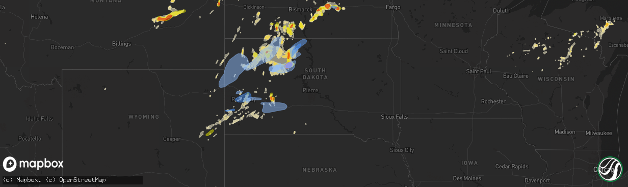
Hail Map in South Dakota on June 8, 2021
The weather event in South Dakota on June 8, 2021 includes Hail, Wind, and Tornado maps. 27 states and 374 cities were impacted and suffered possible damage. The total estimated number of properties impacted is 883.
Hail
Wind
Tornado
883
Estimated number of impacted properties by a 1.00" hail or larger397
Estimated number of impacted properties by a 1.75" hail or larger140
Estimated number of impacted properties by a 2.50" hail or largerStorm reports in South Dakota
South Dakota
| Date | Description |
|---|---|
| 06/08/20216:58 PM CDT | A local report indicates 62 MPH wind near 1 N BUFFALO |
| 06/08/20216:46 PM CDT | A local report indicates 67 MPH wind near 4 N LUDLOW |
| 06/08/20216:18 PM CDT | A local report indicates 1.75 inch wind near 2 N FIRESTEEL |
| 06/08/20216:06 PM CDT | A local report indicates 63 MPH wind near 7 S SHADEHILL |
| 06/08/20215:56 PM CDT | At least ping pong ball at largest. Hail for 30 minutes... Just ended. |
| 06/08/20215:55 PM CDT | A local report indicates 59 MPH wind near 7 SSE MEADOW |
| 06/08/20215:05 PM CDT | Mesonet station mcts2 mcintosh |
| 06/08/20213:38 PM CDT | A local report indicates 1.50 inch wind near 7 NE QUINN |
| 06/08/20216:58 AM CDT | At 1157 PM CDT/1057 PM MDT/, a severe thunderstorm was located 6 miles southwest of Thunder Hawk, or 7 miles southeast of Lemmon, moving north at 50 mph. HAZARD...60 mph wind gusts. SOURCE...Radar indicated. IMPACT...Expect damage to roofs, siding, and trees. Locations impacted include... New Leipzig. |
| 06/08/20215:54 AM CDT | At 1054 PM MDT, severe thunderstorms were located along a line extending from near Shadehill to 7 miles north of Iron Lightning to near Intersection of Cherry Creek and Sunnybrook Roads to near Bridger, moving northeast at 40 mph. HAZARD...60 mph wind gusts and penny size hail. SOURCE...Radar indicated. IMPACT...Expect damage to roofs, siding, and trees. Severe thunderstorms will be near... Thunder Hawk around 1110 PM MDT.Other locations in the path of these severe thunderstorms includeLantry, Bear Creek, Keldron, Green Grass, Klein Ranch, Black Horse,Eagle Butte, Timber Lake, Little Moreau Rec Area and Parade. |
| 06/08/20215:50 AM CDT | At 1049 PM MDT, severe thunderstorms were located along a line extending from 8 miles southwest of Shambo Ranch to 5 miles south of Red Elm to near Bridger, moving east at 30 mph. HAZARD...60 mph wind gusts and penny size hail. SOURCE...Radar indicated. IMPACT...Expect damage to roofs, siding, and trees. Severe thunderstorms will be near... Red Elm around 1055 PM MDT.Other locations in the path of these severe thunderstorms includeDupree, Glad Valley, Cherry Creek, South Eagle Butte and Kirley. |
| 06/08/20214:12 AM CDT | At 912 PM MDT, a severe thunderstorm was located near Green Grass, or 12 miles north of Eagle Butte, moving northeast at 25 mph. HAZARD...Two inch hail and 70 mph wind gusts. SOURCE...Radar indicated. IMPACT...People and animals outdoors will be injured. Expect hail damage to roofs, siding, windows, and vehicles. Expect considerable tree damage. Wind damage is also likely to mobile homes, roofs, and outbuildings. Locations impacted include... White Horse. |
| 06/08/20214:10 AM CDT | At 909 PM MDT, a severe thunderstorm was located 6 miles northeast of Date, or 38 miles south of Hettinger, moving north at 10 mph. HAZARD...Quarter size hail. SOURCE...Radar indicated. IMPACT...Damage to vehicles is expected. Locations impacted include... Bison. |
| 06/08/20213:44 AM CDT | At 844 PM MDT, severe thunderstorms were located along a line extending from 3 miles north of Newell Lake to 7 miles northeast of Bear Butte State Park to 5 miles east of Black Hawk, moving northeast at 35 mph. HAZARD...60 mph wind gusts and penny size hail. SOURCE...Radar indicated. IMPACT...Expect damage to roofs, siding, and trees. Severe thunderstorms will be near... Castle Rock around 850 PM MDT.Other locations in the path of these severe thunderstorms includeDears Ears Butte, Viewfield, Hereford, Curlew Lake, Mud Butte andFairpoint.This includes Interstate 90 in South Dakota between Mile Markers 23and 53. |
| 06/08/20213:41 AM CDT | At 840 PM MDT, severe thunderstorms were located along a line extending from Rapid City to 3 miles south of Hayward to 2 miles south of Pringle, moving east at 25 mph. HAZARD...60 mph wind gusts and penny size hail. SOURCE...Radar indicated. IMPACT...Expect damage to roofs, siding, and trees. Severe thunderstorms will be near... Rapid City, Rapid Valley, Black Hawk and Hayward around 845 PM MDT. Southern Ellsworth Air Force Base, Box Elder and Hermosa around 855 PM MDT. Rapid City Airport around 900 PM MDT.Other locations in the path of these severe thunderstorms includeBuffalo Corrals, Thompson Butte, New Underwood, Fairburn, Folsom andRailroad Buttes.This includes Interstate 90 in South Dakota between Mile Markers 54and 84. |
| 06/08/20213:28 AM CDT | At 827 PM MDT, a severe thunderstorm was located near Bear Creek, or near Dupree, moving east at 15 mph. HAZARD...70 mph wind gusts and quarter size hail. SOURCE...Radar indicated. IMPACT...Hail damage to vehicles is expected. Expect considerable tree damage. Wind damage is also likely to mobile homes, roofs, and outbuildings. This severe thunderstorm will be near... Bear Creek around 840 PM MDT.Other locations in the path of this severe thunderstorm include GreenGrass. |
| 06/08/20213:20 AM CDT | At 820 PM MDT, a severe thunderstorm was located 8 miles southwest of Owen Lake, or 31 miles northwest of Faith, moving east at 20 mph. HAZARD...60 mph wind gusts and quarter size hail. SOURCE...Radar indicated. IMPACT...Hail damage to vehicles is expected. Expect wind damage to roofs, siding, and trees. This severe thunderstorm will be near... Owen Lake around 840 PM MDT.Other locations in the path of this severe thunderstorm includeChance and Meadow. |
| 06/08/20212:59 AM CDT | At 759 PM MDT, a severe thunderstorm was located near Red Elm, or 9 miles west of Dupree, moving east at 25 mph. HAZARD...60 mph wind gusts and quarter size hail. SOURCE...Radar indicated. IMPACT...Hail damage to vehicles is expected. Expect wind damage to roofs, siding, and trees. Locations impacted include... Dupree. |
| 06/08/20212:46 AM CDT | At 745 PM MDT, severe thunderstorms were located along a line extending from near Crooks Tower to 8 miles south of Moon to near Dewey, moving east at 30 mph. HAZARD...60 mph wind gusts and penny size hail. SOURCE...Radar indicated. IMPACT...Expect damage to roofs, siding, and trees. Severe thunderstorms will be near... Flag Mountain and Deerfield around 750 PM MDT. Jewel Cave National Monument around 755 PM MDT. Rochford and Bear Mountain Lookout around 805 PM MDT.Other locations in the path of these severe thunderstorms includeMystic, Medicine Mountain, Crazy Horse Memorial, Custer, Silver City,Custer State Park, Pactola Reservoir, Hill City, Argyle, Black ElkPeak, Sylvan Lake, Palmer Gulch Resort, Stockade Lake, JohnsonSiding, Pringle, Horse Thief Lake, Sheridan Lake, Cottonwood SpringsDam and Legion Lake.This includes Interstate 90 in South Dakota between Mile Markers 54and 57. |
| 06/08/20212:25 AM CDT | At 725 PM MDT, a severe thunderstorm was located near Timber Lake, or 29 miles north of Eagle Butte, moving northeast at 20 mph. HAZARD...60 mph wind gusts and quarter size hail. SOURCE...Radar indicated. IMPACT...Hail damage to vehicles is expected. Expect wind damage to roofs, siding, and trees. This severe thunderstorm will be near... Timber Lake around 735 PM MDT.Other locations in the path of this severe thunderstorm includeGlencross and Spring Lake. |
| 06/08/20212:11 AM CDT | At 711 PM MDT, a severe thunderstorm was located near Spring Lake, or 21 miles south of Mclaughlin, moving east at 15 mph. HAZARD...60 mph wind gusts and quarter size hail. SOURCE...Radar indicated. IMPACT...Hail damage to vehicles is expected. Expect wind damage to roofs, siding, and trees. This severe thunderstorm will be near... Glencross around 720 PM MDT. Spring Lake around 725 PM MDT.Other locations in the path of this severe thunderstorm include TrailCity. |
| 06/08/20211:17 AM CDT | At 616 PM MDT, severe thunderstorms were located along a line extending from 11 miles east of Klein Ranch to Firesteel, moving southeast at 25 mph. HAZARD...60 mph wind gusts and quarter size hail. SOURCE...Radar indicated. IMPACT...Hail damage to vehicles is expected. Expect wind damage to roofs, siding, and trees. Locations impacted include... Little Moreau Rec Area, Timber Lake, Spring Lake and Glencross. |
| 06/08/202112:54 AM CDT | At 553 PM MDT, a severe thunderstorm was located 11 miles northwest of Shambo Ranch, or 21 miles south of Lemmon, moving east at 25 mph. HAZARD...60 mph wind gusts and quarter size hail. SOURCE...Radar indicated. IMPACT...Hail damage to vehicles is expected. Expect wind damage to roofs, siding, and trees. This severe thunderstorm will remain over mainly rural areas of northwestern Corson County. |
| 06/08/202112:34 AM CDT | A local report indicates 62 MPH wind near 4 E CACTUS FLAT |
| 06/08/202112:24 AM CDT | A local report indicates 58 MPH wind near 4 E CACTUS FLAT |
| 06/08/202112:23 AM CDT | At 523 PM MDT, a severe thunderstorm was located 8 miles east of Shambo Ranch, or 34 miles north of Dupree, moving east at 30 mph. HAZARD...60 mph wind gusts and quarter size hail. SOURCE...Radar indicated. IMPACT...Hail damage to vehicles is expected. Expect wind damage to roofs, siding, and trees. Locations impacted include... Klein Ranch. |
| 06/08/202112:20 AM CDT | A local report indicates 59 MPH wind near 8 S WALL |
| 06/07/202111:54 PM CDT | A local report indicates 64 MPH wind near 1 WSW RED ELM |
| 06/07/202111:54 PM CDT | A local report indicates 64 MPH wind near 7 SSE MEADOW |
| 06/07/202111:46 PM CDT | At 446 PM MDT, a severe thunderstorm was located near Green Grass, or 18 miles north of Eagle Butte, moving north at 15 mph. HAZARD...60 mph wind gusts and quarter size hail. SOURCE...Radar indicated. IMPACT...Hail damage to vehicles is expected. Expect wind damage to roofs, siding, and trees. Locations impacted include... Firesteel and Timber Lake. |
| 06/07/202111:45 PM CDT | A local report indicates 59 MPH wind near 8 S WALL |
| 06/07/202111:44 PM CDT | A local report indicates 62 MPH wind near 3 NW WASTA |
| 06/07/202111:39 PM CDT | A local report indicates 59 MPH wind near 3 NW WASTA |
| 06/07/202111:19 PM CDT | A local report indicates 60 MPH wind near 7 SSE MEADOW |
| 06/07/202111:19 PM CDT | A local report indicates 61 MPH wind near 3 NW WASTA |
| 06/07/202111:09 PM CDT | A local report indicates 61 MPH wind near 5 WNW NEW UNDERWOOD |
| 06/07/202111:00 PM CDT | A local report indicates 1.00 inch wind near 6 W HERMOSA |
| 06/07/202110:51 PM CDT | A local report indicates 68 MPH wind near 4 N LUDLOW |
| 06/07/202110:45 PM CDT | At 345 PM MDT, a severe thunderstorm was located near Watauga, or 26 miles east of Lemmon, moving northeast at 10 mph. HAZARD...60 mph wind gusts and half dollar size hail. SOURCE...Radar indicated. IMPACT...Hail damage to vehicles is expected. Expect wind damage to roofs, siding, and trees. This severe thunderstorm will be near... Watauga around 405 PM MDT. |
| 06/07/202110:36 PM CDT | A local report indicates 59 MPH wind near 10 W EDGEMONT |
| 06/07/202110:04 PM CDT | A local report indicates 1.00 inch wind near 7 NNE ELLSWORTH AFB |
| 06/07/20219:55 PM CDT | A local report indicates 63 MPH wind near 7 NNE ELLSWORTH AFB |
| 06/07/20219:45 PM CDT | A local report indicates 68 MPH wind near 12 WSW CASTLE ROCK |
| 06/07/20219:45 PM CDT | Also pea to nickel size hail. |
| 06/07/20219:39 PM CDT | Mesonet station lans2 lantry 3 nw. Time estimated by radar. Gust occurred between 852 pm and 952 pm cdt. |
| 06/07/20219:37 PM CDT | Damage to branches and rain gauge. |
| 06/07/20219:30 PM CDT | A local report indicates 59 MPH wind near 1 WSW RED ELM |
| 06/07/20219:25 PM CDT | A local report indicates 58 MPH wind near 13 NW BELLE FOURCHE |
| 06/07/20219:20 PM CDT | At 220 PM MDT, a severe thunderstorm was located over Grindstone, or 14 miles west of Philip, moving north at 20 mph. HAZARD...60 mph wind gusts and half dollar size hail. SOURCE...Radar indicated. IMPACT...Hail damage to vehicles is expected. Expect wind damage to roofs, siding, and trees. This severe thunderstorm will be near... Grindstone around 225 PM MDT. |
| 06/07/20219:15 PM CDT | Also had pea to marble size hail. |
| 06/07/20219:06 PM CDT | A local report indicates 86 MPH wind near 1 WSW RED ELM |
| 06/07/20219:05 PM CDT | A local report indicates 62 MPH wind near 13 NW BELLE FOURCHE |
| 06/07/20219:00 PM CDT | Some door and roof damage to a barn. A semi trailer was blown over. |
| 06/07/20218:54 PM CDT | Mesonet station 293 timber lake |
| 06/07/20218:49 PM CDT | A local report indicates 1.00 inch wind near TIMBER LAKE |
| 06/07/20218:44 PM CDT | A local report indicates 64 MPH wind near 1 WSW RED ELM |
| 06/07/20218:42 PM CDT | A local report indicates 64 MPH wind near 1 NNE FAITH |
| 06/07/20218:39 PM CDT | Mesonet station 293 timber lake |
| 06/07/20218:30 PM CDT | 70-80 mph wind gusts |
| 06/07/20218:19 PM CDT | Mesonet station 293 timber lake |
| 06/07/20218:18 PM CDT | Preliminary info. Time and location approximated and based on radar/reports. Spotter reported a tornado. |
| 06/07/20217:40 PM CDT | Mesonet station grrs2 bullhead 10 s. Time estimated. |
| 06/07/20217:20 PM CDT | Small tree limbs down. |
| 06/07/20217:06 PM CDT | A local report indicates 58 MPH wind near 4 N LUDLOW |
| 06/07/20217:00 PM CDT | A local report indicates 1.00 inch wind near 2 N FIRESTEEL |
All States Impacted by Hail Map on June 8, 2021
Cities Impacted by Hail Map on June 8, 2021
- Merrill, WI
- Fe Warren Afb, WY
- Cheyenne, WY
- Winsted, CT
- Pine Bluffs, WY
- Bushnell, NE
- Pelican Lake, WI
- New England, ND
- Timber Lake, SD
- Forsyth, MT
- Rosebud, MT
- Flasher, ND
- McIntosh, SD
- Hettinger, ND
- Lemmon, SD
- Regent, ND
- Fort Peck, MT
- Brockton, MT
- Glendive, MT
- Foster City, MI
- Sturgis, SD
- Piedmont, SD
- Kadoka, SD
- Seney, MI
- Hermosa, SD
- Rapid City, SD
- Caputa, SD
- Paradise, MI
- Lantry, SD
- Dupree, SD
- Bison, SD
- Prairie City, SD
- Frazer, MT
- Wolf Point, MT
- Bowman, ND
- Goshen, AL
- Coffeeville, AL
- Jackson, AL
- Fairview, MT
- Wibaux, MT
- Cartwright, ND
- Beach, ND
- Bloomfield, MT
- Savage, MT
- Froid, MT
- Culbertson, MT
- Richey, MT
- Lambert, MT
- Jamestown, ND
- Carson, ND
- Center, ND
- Keystone, SD
- Ellsworth Afb, SD
- Custer, SD
- Box Elder, SD
- Tappen, ND
- Cohagen, MT
- Brockway, MT
- Circle, MT
- Gleason, WI
- Dickinson, ND
- Lefor, ND
- Gladstone, ND
- Meadow, SD
- Malta, MT
- Elgin, ND
- Glen Ullin, ND
- Long Lake, WI
- Fairfield, ND
- Cleveland, ND
- Medina, ND
- Isabel, SD
- Woodstown, NJ
- Salem, NJ
- Palmer, MI
- Negaunee, MI
- Thief River Falls, MN
- Braddock, ND
- Hazelton, ND
- Rice Lake, WI
- Deerbrook, WI
- Oakfield, GA
- Sagola, MI
- Belle Fourche, SD
- Norway, MI
- Niagara, WI
- Dunbar, WI
- Quinnesec, MI
- Pembine, WI
- Alzada, MT
- Viking, MN
- Argyle, MN
- Barron, WI
- Jordan, MT
- McLaughlin, SD
- Newell, SD
- Mud Butte, SD
- Watauga, SD
- Reva, SD
- Eagle Butte, SD
- Trail City, SD
- Selfridge, ND
- Faith, SD
- Keldron, SD
- Morristown, SD
- Buffalo Gap, SD
- Fairburn, SD
- Dawson, ND
- Kintyre, ND
- Steele, ND
- Linton, ND
- Driscoll, ND
- Moffit, ND
- Wing, ND
- Raleigh, ND
- Hot Springs, SD
- Germfask, MI
- Hinsdale, MT
- Buffalo, SD
- Camp Crook, SD
- Wall, SD
- Wausau, WI
- Phillips, WI
- Valentine, NE
- Westboro, WI
- Medford, WI
- Laona, WI
- Cameron, WI
- Shields, ND
- Big Springs, NE
- Brinson, GA
- Colquitt, GA
- Bainbridge, GA
- Edgemont, SD
- Carbon Hill, AL
- Belfield, ND
- Mott, ND
- Gwinn, MI
- Republic, MI
- Channing, MI
- Champion, MI
- New Underwood, SD
- Butler, AL
- Needham, AL
- Ripon, WI
- Saco, MT
- Pine Ridge, SD
- Enning, SD
- Andersonville, GA
- Americus, GA
- Leary, GA
- Fort Yates, ND
- Cannon Ball, ND
- Solen, ND
- Leesburg, GA
- Smithville, GA
- Antigo, WI
- Ishpeming, MI
- New Leipzig, ND
- Quinn, SD
- Skandia, MI
- Felch, MI
- Elmer, NJ
- Monroeville, NJ
- Nashua, MT
- Sidney, MT
- Armstrong Creek, WI
- Winter, WI
- Three Lakes, WI
- Eagle River, WI
- Chappell, NE
- Staten Island, NY
- Marquette, MI
- Lance Creek, WY
- Tuckerton, NJ
- Egg Harbor City, NJ
- Chatsworth, NJ
- Vincentown, NJ
- Ojibwa, WI
- Lodgepole, NE
- Saugerties, NY
- Catskill, NY
- Montgomery, AL
- Hope Hull, AL
- Rhinelander, WI
- Iron River, MI
- Colebrook, CT
- Norfolk, CT
- Hogansville, GA
- Phelps, WI
- Damascus, GA
- Clifford, MI
- Burns, WY
- Upton, WY
- Elcho, WI
- Iron Mountain, MI
- Tripoli, WI
- Brilliant, AL
- Winfield, AL
- Guin, AL
- Ladysmith, WI
- West Chester, PA
- Kennett Square, PA
- Prentice, WI
- Woodcliff Lake, NJ
- Hillsdale, NJ
- Westwood, NJ
- Dawson, GA
- Howes, SD
- Summit Lake, WI
- Argonne, WI
- Crookston, MN
- Red Lake Falls, MN
- Aladdin, WY
- Alva, WY
- Hulett, WY
- Black Hawk, SD
- Dorchester, WI
- Abbotsford, WI
- Newberry, MI
- Marshall, VA
- Hume, VA
- Park Falls, WI
- Ellaville, GA
- Township Of Washington, NJ
- Park Ridge, NJ
- Harrington Park, NJ
- Emerson, NJ
- Tony, WI
- Cody, WY
- Philip, SD
- Reynolds, GA
- Medora, ND
- Regan, ND
- Baldwin, ND
- Florida, NY
- Chester, NY
- Goshen, NY
- Amidon, ND
- East Orange, NJ
- Newark, NJ
- New Salem, ND
- Stanton, ND
- Crystal Falls, MI
- Poplar, MT
- Terry, MT
- Hawkins, WI
- Mission, SD
- Lusk, WY
- Angela, MT
- Kinsey, MT
- Bronwood, GA
- Plains, GA
- Elko, GA
- Warren, MN
- Fort Monmouth, NJ
- Eatontown, NJ
- Otisville, MI
- Olivebridge, NY
- Ackerman, MS
- Weir, MS
- Newcastle, WY
- Belmar, NJ
- Spring Lake, NJ
- Sundance, WY
- Thorp, WI
- McMillan, MI
- Birmingham, MI
- Vulcan, MI
- Saint Francis, SD
- Marianna, FL
- Cottondale, FL
- Athelstane, WI
- Conowingo, MD
- Hysham, MT
- Sanders, MT
- Glen Flora, WI
- Bloomfield Hills, MI
- Pontiac, MI
- McGehee, AR
- Tillar, AR
- Carpenter, WY
- Irma, WI
- Franklin, AL
- Ainsworth, NE
- Brantwood, WI
- Wanblee, SD
- Millville, MA
- Oglethorpe, GA
- Lac Du Flambeau, WI
- Woodworth, ND
- Pettibone, ND
- Demopolis, AL
- Wabeno, WI
- Manville, WY
- Hammonton, NJ
- Yale, MI
- Melvin, MI
- Columbiaville, MI
- Macon, MS
- Newport, TN
- Franklin, GA
- Tifton, GA
- Ty Ty, GA
- Omega, GA
- New Brockton, AL
- Kyle, SD
- Ogema, WI
- Moorcroft, WY
- Bloomer, WI
- Williamstown, NJ
- Franklinville, NJ
- Brokaw, WI
- Warwick, NY
- Glenwood, NJ
- Vernon, NJ
- Hawkinsville, GA
- Ocilla, GA
- Fitzgerald, GA
- Kingsford, MI
- Douglas, MA
- Middletown, NY
- Montgomery, NY
- Shreve, OH
- Wisdom, MT
- Swiftwater, PA
- Mount Pocono, PA
- Carteret, NJ
- Irvington, NJ
- Vauxhall, NJ
- Springfield, NJ
- Elizabeth, NJ
- Maplewood, NJ
- Millburn, NJ
- Hillside, NJ
- Union, NJ
- Hazen, ND
- Beulah, ND
- Shawnee, WY
- Tuttle, ND
- Douglas, WY
- Livermore, CO
- Alvarado, MN
- Meridian, MS
- Collinston, LA
- West Monroe, LA
- Columbia, LA
- Monroe, LA
- Mangham, LA
- Rayville, LA
- Oak Ridge, LA
- Williston, ND
- Bainville, MT
- Trenton, ND
- Lost Springs, WY
- Hillsdale, WY
- Patoka, IN
- Little Eagle, SD
- Wakpala, SD
- Glencross, SD
- Spearfish, SD
- Nisland, SD
- Saint Onge, SD
- Beulah, WY
- Deadwood, SD
- Nemo, SD
- Owanka, SD
- Wasta, SD
- Scenic, SD
- Belvidere, SD
- Interior, SD
- Tyler, TX
- Reklaw, TX
- Whitewater, MT


