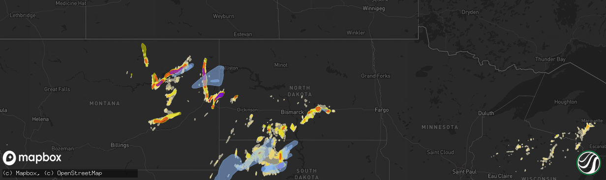
Hail Map in North Dakota on June 8, 2021
The weather event in North Dakota on June 8, 2021 includes Hail, Wind, and Tornado maps. 27 states and 374 cities were impacted and suffered possible damage. The total estimated number of properties impacted is 3,433.
Hail
Wind
Tornado
3,433
Estimated number of impacted properties by a 1.00" hail or larger694
Estimated number of impacted properties by a 1.75" hail or larger152
Estimated number of impacted properties by a 2.50" hail or largerStorm reports in North Dakota
North Dakota
| Date | Description |
|---|---|
| 06/08/20214:11 PM CDT | Mesonet station tt584 12 e mott. |
| 06/08/20213:48 PM CDT | Time estimated from radar. |
| 06/08/20213:40 PM CDT | A local report indicates 1.00 inch wind near 1 E ELGIN |
| 06/08/20213:35 PM CDT | A local report indicates 60 MPH wind near ELGIN |
| 06/08/20211:30 PM CDT | Hail was mostly pea size... But there were some larger stones mixed in up to golf ball size. |
| 06/08/202112:47 PM CDT | Mesonet station at long lake nwr. Time estimated from radar. |
| 06/08/202111:45 AM CDT | Hail was accompanied by a few wind gusts to 60 mph. Measured 4 inches of rain as of 1145 am and it was still raining. |
| 06/08/202110:20 AM CDT | Trees down in steele. |
| 06/08/202110:15 AM CDT | Trees down... Reported by law enforcement. |
| 06/08/20218:23 AM CDT | Dot sensor reported a 70 mph wind gust. |
| 06/08/20217:59 AM CDT | At 1259 PM CDT, a severe thunderstorm was located near Prairie Knights Resort, or 13 miles north of Fort Yates, and is nearly stationary. HAZARD...60 mph wind gusts and half dollar size hail. SOURCE...Radar indicated. IMPACT...Hail damage to vehicles is expected. Expect wind damage to roofs, siding, and trees. Locations impacted include... Cannon Ball. |
| 06/08/20217:50 AM CDT | Estimated 70 mph winds with pea size hail. |
| 06/08/20217:30 AM CDT | Damage to shed. Report received via social media. |
| 06/08/20217:26 AM CDT | At 1226 AM CDT, a severe thunderstorm was located 8 miles northeast of Edgeley, moving east at 25 mph. HAZARD...60 mph wind gusts and half dollar size hail. SOURCE...Radar indicated. IMPACT...Hail damage to vehicles is expected. Expect wind damage to roofs, siding, and trees. Locations impacted include... Lamoure and Verona. |
| 06/08/20217:23 AM CDT | At 1223 PM CDT, severe thunderstorms were located along a line extending from 9 miles north of Braddock to near Hazelton, moving north at 5 mph. HAZARD...60 mph wind gusts and quarter size hail. SOURCE...Radar indicated. IMPACT...Hail damage to vehicles is expected. Expect wind damage to roofs, siding, and trees. These severe thunderstorms will remain over mainly rural areas of southwestern Kidder, southeastern Burleigh and northern Emmons Counties, including the following locations... Hazelton, Kintyre, and Temvik. |
| 06/08/20216:27 AM CDT | At 1127 AM CDT, a severe thunderstorm was located near Hazelton, or 18 miles north of Linton, and is nearly stationary. HAZARD...60 mph wind gusts and quarter size hail. SOURCE...Radar indicated. IMPACT...Hail damage to vehicles is expected. Expect wind damage to roofs, siding, and trees. Locations impacted include... Braddock. |
| 06/08/20216:14 AM CDT | At 1113 PM CDT/1013 PM MDT/, severe thunderstorms were located along a line extending from Bainville to 9 miles south of Savage, moving east at 40 mph. HAZARD...60 mph wind gusts. SOURCE...Radar indicated. IMPACT...Expect damage to roofs, siding, and trees. Locations impacted include... Williston. |
| 06/08/20215:44 AM CDT | At 1044 AM CDT, a severe thunderstorm was located 9 miles northeast of Braddock, or 13 miles south of Steele, moving northeast at 10 mph. HAZARD...60 mph wind gusts and quarter size hail. SOURCE...Radar indicated. IMPACT...Hail damage to vehicles is expected. Expect wind damage to roofs, siding, and trees. Locations impacted include... Lake Isabel. |
| 06/08/20215:06 AM CDT | At 1004 AM CDT, severe thunderstorms were located along a line extending from 6 miles southwest of Steele to 7 miles west of Medina, and are nearly stationary. HAZARD...60 mph wind gusts and quarter size hail. SOURCE...Radar indicated. IMPACT...Hail damage to vehicles is expected. Expect wind damage to roofs, siding, and trees. These severe thunderstorms will remain over mainly rural areas of southern Kidder County, including the following locations... Crystal Springs. |
| 06/08/20214:04 AM CDT | At 904 AM CDT, severe thunderstorms were located along a line extending from 6 miles south of Steele to near Dawson to near Tappen, moving southwest at 10 mph. HAZARD...60 mph wind gusts and quarter size hail. SOURCE...Radar indicated. IMPACT...Hail damage to vehicles is expected. Expect wind damage to roofs, siding, and trees. Locations impacted include... Steele, Tappen, and Dawson. |
| 06/08/20213:12 AM CDT | At 811 PM CDT/711 PM MDT/, a severe thunderstorm was located 18 miles northeast of Trotters, or 25 miles southeast of Sidney, moving northeast at 25 mph. HAZARD...60 mph wind gusts and quarter size hail. SOURCE...Radar indicated. IMPACT...Hail damage to vehicles is expected. Expect wind damage to roofs, siding, and trees. This severe thunderstorm will remain over mainly rural areas of southwestern McKenzie County, including the following locations... Sather Dam. |
| 06/08/20213:02 AM CDT | At 802 AM CDT, a severe thunderstorm was located 5 miles northeast of Tappen, or 13 miles west of Medina, moving northeast at 15 mph. HAZARD...60 mph wind gusts and quarter size hail. SOURCE...Radar indicated. IMPACT...Hail damage to vehicles is expected. Expect wind damage to roofs, siding, and trees. This severe thunderstorm will remain over mainly rural areas of east central Kidder County, including the following locations... Crystal Springs. |
| 06/08/20212:50 AM CDT | At 749 AM CDT, a severe thunderstorm was located near Medina, and is nearly stationary. HAZARD...70 mph wind gusts and quarter size hail. SOURCE...Law enforcement. IMPACT...Hail damage to vehicles is expected. Expect considerable tree damage. Wind damage is also likely to mobile homes, roofs, and outbuildings. This severe thunderstorm will be near... Cleveland around 755 AM CDT. |
| 06/08/20212:22 AM CDT | At 721 PM MDT, a severe thunderstorm was located 10 miles northwest of South Fairfield, or 30 miles west of Killdeer, moving north at 25 mph. HAZARD...60 mph wind gusts and half dollar size hail. SOURCE...Radar indicated. IMPACT...Hail damage to vehicles is expected. Expect wind damage to roofs, siding, and trees. Locations impacted include... Grassy Butte. |
| 06/08/20212:07 AM CDT | At 707 AM CDT, a severe thunderstorm was located near Medina, moving northeast at 30 mph. HAZARD...Half dollar size hail. SOURCE...Radar indicated. IMPACT...Damage to vehicles is expected. This severe thunderstorm will be near... Cleveland around 710 AM CDT. |
| 06/08/20211:09 AM CDT | At 608 AM CDT, a severe thunderstorm was located over Marion, or 24 miles northeast of Edgeley, moving east at 10 mph. HAZARD...Ping pong ball size hail and 60 mph wind gusts. SOURCE...Radar indicated. IMPACT...People and animals outdoors will be injured. Expect hail damage to roofs, siding, windows, and vehicles. Expect wind damage to roofs, siding, and trees. Locations impacted include... Marion. |
| 06/08/20211:00 AM CDT | At 600 AM CDT, a severe thunderstorm was located 5 miles west of Ypsilanti, or 9 miles south of Jamestown, moving east at 15 mph. HAZARD...Ping pong ball size hail and 60 mph wind gusts. SOURCE...Radar indicated. IMPACT...People and animals outdoors will be injured. Expect hail damage to roofs, siding, windows, and vehicles. Expect wind damage to roofs, siding, and trees. This severe thunderstorm will be near... Montpelier around 615 AM CDT. Ypsilanti around 620 AM CDT. |
| 06/08/202112:44 AM CDT | At 543 AM CDT, a severe thunderstorm was located over Fort Ransom, or 26 miles south of Valley City, and is nearly stationary. HAZARD...Two inch hail. SOURCE...Radar indicated. IMPACT...People and animals outdoors will be injured. Expect damage to roofs, siding, windows, and vehicles. Locations impacted include... Fort Ransom, Fort Ransom State Park, Nome and Little Yellowstone. |
| 06/08/202112:28 AM CDT | At 528 PM CDT/428 PM MDT/, a severe thunderstorm was located 9 miles south of Shields, or 11 miles west of Selfridge, moving east at 10 mph. HAZARD...60 mph wind gusts and half dollar size hail. SOURCE...Radar indicated. IMPACT...Hail damage to vehicles is expected. Expect wind damage to roofs, siding, and trees. This severe thunderstorm will remain over mainly rural areas of south central Sioux and southeastern Grant Counties, including the following locations... Porcupine. |
| 06/08/202112:27 AM CDT | At 527 PM MDT, severe thunderstorms were located along a line extending from 8 miles southwest of Lambert to 13 miles north of Wibaux, moving north at 40 mph. HAZARD...Ping pong ball size hail and 60 mph wind gusts. SOURCE...Radar indicated. IMPACT...People and animals outdoors will be injured. Expect hail damage to roofs, siding, windows, and vehicles. Expect wind damage to roofs, siding, and trees. Locations impacted include... Sidney, Culbertson, Fairview, Brockton, Savage, Lambert, Skaar, Intake, East Fairview, Fort Kipp, Enid, Wooley, Crane, Midway and Burns. |
| 06/08/202112:08 AM CDT | Williams lookout raws station. Time estimated from radar. |
| 06/08/202112:00 AM CDT | At 459 AM CDT, a severe thunderstorm was located near Ypsilanti, or 23 miles southwest of Valley City, moving east at 20 mph. HAZARD...Two inch hail. SOURCE...Radar indicated. IMPACT...People and animals outdoors will be injured. Expect damage to roofs, siding, windows, and vehicles. Locations impacted include... Sanborn, Litchville, Hastings, Eckelson and Urbana. |
| 06/07/202111:57 PM CDT | At 456 AM CDT, a severe thunderstorm was located near Jamestown, moving east at 15 mph. HAZARD...Ping pong ball size hail and 60 mph wind gusts. SOURCE...Radar indicated. IMPACT...People and animals outdoors will be injured. Expect hail damage to roofs, siding, windows, and vehicles. Expect wind damage to roofs, siding, and trees. This severe thunderstorm will be near... Ypsilanti around 515 AM CDT.Other locations in the path of this severe thunderstorm includeSpiritwood. |
| 06/07/202111:54 PM CDT | At 454 PM MDT, a severe thunderstorm was located over Meadow, or 27 miles south of Lemmon, moving northeast at 30 mph. HAZARD...60 mph wind gusts and quarter size hail. SOURCE...Radar indicated. IMPACT...Hail damage to vehicles is expected. Expect wind damage to roofs, siding, and trees. Locations impacted include... Shadehill and Meadow. |
| 06/07/202111:50 PM CDT | Facebook report of strong winds north of hettinger. Picked up and carried 24 foot oil pipe and super steel wind break panel. |
| 06/07/202111:48 PM CDT | Tree down from severe wind... Estimated gust 60mph. On nd side of border with montana on highway 2. |
| 06/07/202111:47 PM CDT | At 447 AM CDT, a severe thunderstorm was located 7 miles west of Fort Ransom, or 26 miles south of Valley City, moving east at 20 mph. HAZARD...Ping pong ball size hail. SOURCE...Radar indicated. IMPACT...People and animals outdoors will be injured. Expect damage to roofs, siding, windows, and vehicles. Locations impacted include... Lisbon, Enderlin, Fort Ransom, Englevale, Elliott and Little Yellowstone. |
| 06/07/202111:46 PM CDT | At 446 AM CDT, a severe thunderstorm was located 8 miles south of Litchville, or 26 miles south of Valley City, moving southeast at 15 mph. HAZARD...Ping pong ball size hail and 60 mph wind gusts. SOURCE...Radar indicated. IMPACT...People and animals outdoors will be injured. Expect hail damage to roofs, siding, windows, and vehicles. Expect wind damage to roofs, siding, and trees. This severe thunderstorm will remain over mainly rural areas of northeastern LaMoure County. |
| 06/07/202111:44 PM CDT | A local report indicates 73 MPH wind near 10 N FORT UNION TRADING |
| 06/07/202111:41 PM CDT | At 440 PM CDT/340 PM MDT/, a severe thunderstorm was located 6 miles southwest of Shields, or 17 miles northwest of Selfridge, nearly stationary. HAZARD...60 mph wind gusts and half dollar size hail. SOURCE...Radar indicated. IMPACT...Hail damage to vehicles is expected. Expect wind damage to roofs, siding, and trees. This severe thunderstorm will be near... Shields around 450 PM CDT. |
| 06/07/202111:37 PM CDT | At 436 PM MDT, severe thunderstorms were located along a line extending from 6 miles northeast of Glendive to 8 miles west of Wibaux to 15 miles northwest of Carlyle, moving north at 10 mph. HAZARD...60 mph wind gusts and nickel size hail. SOURCE...Radar indicated. IMPACT...Expect damage to roofs, siding, and trees. Locations impacted include... Glendive, Wibaux, Savage, Intake, Hodges, Stipek, Midway, Burns and Yates. |
| 06/07/202111:33 PM CDT | At 432 PM MDT, a severe thunderstorm was located 7 miles northwest of Black Horse, or 33 miles east of Lemmon, moving east at 15 mph. HAZARD...60 mph wind gusts and quarter size hail. SOURCE...Radar indicated. IMPACT...Hail damage to vehicles is expected. Expect wind damage to roofs, siding, and trees. Locations impacted include... Black Horse. |
| 06/07/202111:20 PM CDT | A local report indicates 60 MPH wind near 2 SSE SKAAR |
| 06/07/202111:00 PM CDT | At 359 AM CDT, a severe thunderstorm was located 9 miles west of Montpelier, or 11 miles south of Jamestown, moving northeast at 10 mph. HAZARD...Ping pong ball size hail. SOURCE...Radar indicated. IMPACT...People and animals outdoors will be injured. Expect damage to roofs, siding, windows, and vehicles. Locations impacted include... Montpelier and Ypsilanti. |
| 06/07/202110:45 PM CDT | At 344 PM CDT/244 PM MDT/, severe thunderstorms were located along a line extending from 7 miles east of Carson to 7 miles southeast of Flasher, and are nearly stationary. HAZARD...60 mph wind gusts and half dollar size hail. SOURCE...Radar indicated. IMPACT...Hail damage to vehicles is expected. Expect wind damage to roofs, siding, and trees. This severe thunderstorm will be near... Elgin around 255 PM MDT. |
| 06/07/202110:42 PM CDT | At 341 AM CDT, a severe thunderstorm was located over Nome, or 16 miles southeast of Valley City, moving east at 15 mph. HAZARD...Ping pong ball size hail and 60 mph wind gusts. SOURCE...Radar indicated. At 3:35 AM CDT, a report from Litchville estimated baseball sized hail. IMPACT...People and animals outdoors will be injured. Expect hail damage to roofs, siding, windows, and vehicles. Expect wind damage to roofs, siding, and trees. Locations impacted include... Litchville, Hastings and Kathryn. |
| 06/07/202110:11 PM CDT | At 310 AM CDT, a severe thunderstorm was located near Jamestown, moving east at 30 mph. HAZARD...60 mph wind gusts and quarter size hail. SOURCE...Trained weather spotters hail the size of quarters near Jamestown. IMPACT...Hail damage to vehicles is expected. Expect wind damage to roofs, siding, and trees. This severe thunderstorm will be near... Spiritwood around 325 AM CDT. |
| 06/07/20219:45 PM CDT | At 245 AM CDT, a severe thunderstorm was located over Litchville, or 18 miles south of Valley City, moving east at 15 mph. HAZARD...Ping pong ball size hail and 60 mph wind gusts. SOURCE...Radar indicated. IMPACT...People and animals outdoors will be injured. Expect hail damage to roofs, siding, windows, and vehicles. Expect wind damage to roofs, siding, and trees. Locations impacted include... Litchville, Hastings, Kathryn and Little Yellowstone. |
| 06/07/20219:44 PM CDT | At 244 AM CDT, a severe thunderstorm was located near Litchville, or 24 miles southwest of Valley City, moving east at 40 mph. HAZARD...Ping pong ball size hail and 60 mph wind gusts. SOURCE...Radar indicated. IMPACT...People and animals outdoors will be injured. Expect hail damage to roofs, siding, windows, and vehicles. Expect wind damage to roofs, siding, and trees. This severe thunderstorm will remain over mainly rural areas of eastern LaMoure and southeastern Stutsman Counties, including the following locations... Nortonville, Grand Rapids and Millarton. |
| 06/07/20219:43 PM CDT | At 242 PM CDT/142 PM MDT/, severe thunderstorms were located along a line extending from 7 miles east of Carson to 7 miles southeast of Flasher, and are nearly stationary. HAZARD...60 mph wind gusts and half dollar size hail. SOURCE...Radar indicated. IMPACT...Hail damage to vehicles is expected. Expect wind damage to roofs, siding, and trees. Locations impacted include... Carson, Flasher, Heart Butte Dam, Shields, Lark, Raleigh, Leith, Heil, St. Gertrude, and Breien. |
| 06/07/20219:20 PM CDT | Facebook report and photo of a cell tower down near manning. Time estimated based on radar. |
| 06/07/20219:00 PM CDT | Multiple reports of mature trees down in new town... At least 3 to 4 that were 30 to 40 feet in height... Also took out power lines. |
| 06/07/20218:50 PM CDT | Estimated 60 to 70 mph winds knocked over a few trees. |
| 06/07/20218:45 PM CDT | Reports trees down at residence. Reports neighbor machine shed destroyed. Also reports power poles snapped and power outages. |
| 06/07/20218:45 PM CDT | At 145 PM CDT/1245 PM MDT/, severe thunderstorms were located along a line extending from 6 miles northeast of Shields to 4 miles west of Cannon Ball, moving north at 10 mph. HAZARD...60 mph wind gusts and half dollar size hail. SOURCE...Radar indicated. IMPACT...Hail damage to vehicles is expected. Expect wind damage to roofs, siding, and trees. Severe thunderstorms will be near... Solen around 155 PM CDT.Other locations in the path of these severe thunderstorms includeFlasher. |
| 06/07/20218:44 PM CDT | At 144 AM CDT, a severe thunderstorm was located 5 miles northeast of Adrian, or 22 miles southeast of Jamestown, moving northeast at 55 mph. HAZARD...60 mph wind gusts and quarter size hail. SOURCE...Radar indicated. IMPACT...Hail damage to vehicles is expected. Expect wind damage to roofs, siding, and trees. This severe thunderstorm will remain over mainly rural areas of northern LaMoure and southeastern Stutsman Counties, including the following locations... Nortonville. |
| 06/07/20218:39 PM CDT | At 138 AM CDT, a severe thunderstorm was located near Marion, or 25 miles southwest of Valley City, moving northeast at 20 mph. HAZARD...60 mph wind gusts and quarter size hail. SOURCE...Radar indicated. IMPACT...Hail damage to vehicles is expected. Expect wind damage to roofs, siding, and trees. Locations impacted include... Valley City, Litchville, Fingal, Hastings and Kathryn. |
| 06/07/20217:28 PM CDT | A local report indicates 1.75 inch wind near 1 N TROTTERS |
| 06/07/20217:10 PM CDT | A local report indicates 2.75 inch wind near 4 SSE SKAAR |
| 06/07/20217:00 PM CDT | Twitter photo of estimated tennis ball size hail. |
All States Impacted by Hail Map on June 8, 2021
Cities Impacted by Hail Map on June 8, 2021
- Merrill, WI
- Fe Warren Afb, WY
- Cheyenne, WY
- Winsted, CT
- Pine Bluffs, WY
- Bushnell, NE
- Pelican Lake, WI
- New England, ND
- Timber Lake, SD
- Forsyth, MT
- Rosebud, MT
- Flasher, ND
- McIntosh, SD
- Hettinger, ND
- Lemmon, SD
- Regent, ND
- Fort Peck, MT
- Brockton, MT
- Glendive, MT
- Foster City, MI
- Sturgis, SD
- Piedmont, SD
- Kadoka, SD
- Seney, MI
- Hermosa, SD
- Rapid City, SD
- Caputa, SD
- Paradise, MI
- Lantry, SD
- Dupree, SD
- Bison, SD
- Prairie City, SD
- Frazer, MT
- Wolf Point, MT
- Bowman, ND
- Goshen, AL
- Coffeeville, AL
- Jackson, AL
- Fairview, MT
- Wibaux, MT
- Cartwright, ND
- Beach, ND
- Bloomfield, MT
- Savage, MT
- Froid, MT
- Culbertson, MT
- Richey, MT
- Lambert, MT
- Jamestown, ND
- Carson, ND
- Center, ND
- Keystone, SD
- Ellsworth Afb, SD
- Custer, SD
- Box Elder, SD
- Tappen, ND
- Cohagen, MT
- Brockway, MT
- Circle, MT
- Gleason, WI
- Dickinson, ND
- Lefor, ND
- Gladstone, ND
- Meadow, SD
- Malta, MT
- Elgin, ND
- Glen Ullin, ND
- Long Lake, WI
- Fairfield, ND
- Cleveland, ND
- Medina, ND
- Isabel, SD
- Woodstown, NJ
- Salem, NJ
- Palmer, MI
- Negaunee, MI
- Thief River Falls, MN
- Braddock, ND
- Hazelton, ND
- Rice Lake, WI
- Deerbrook, WI
- Oakfield, GA
- Sagola, MI
- Belle Fourche, SD
- Norway, MI
- Niagara, WI
- Dunbar, WI
- Quinnesec, MI
- Pembine, WI
- Alzada, MT
- Viking, MN
- Argyle, MN
- Barron, WI
- Jordan, MT
- McLaughlin, SD
- Newell, SD
- Mud Butte, SD
- Watauga, SD
- Reva, SD
- Eagle Butte, SD
- Trail City, SD
- Selfridge, ND
- Faith, SD
- Keldron, SD
- Morristown, SD
- Buffalo Gap, SD
- Fairburn, SD
- Dawson, ND
- Kintyre, ND
- Steele, ND
- Linton, ND
- Driscoll, ND
- Moffit, ND
- Wing, ND
- Raleigh, ND
- Hot Springs, SD
- Germfask, MI
- Hinsdale, MT
- Buffalo, SD
- Camp Crook, SD
- Wall, SD
- Wausau, WI
- Phillips, WI
- Valentine, NE
- Westboro, WI
- Medford, WI
- Laona, WI
- Cameron, WI
- Shields, ND
- Big Springs, NE
- Brinson, GA
- Colquitt, GA
- Bainbridge, GA
- Edgemont, SD
- Carbon Hill, AL
- Belfield, ND
- Mott, ND
- Gwinn, MI
- Republic, MI
- Channing, MI
- Champion, MI
- New Underwood, SD
- Butler, AL
- Needham, AL
- Ripon, WI
- Saco, MT
- Pine Ridge, SD
- Enning, SD
- Andersonville, GA
- Americus, GA
- Leary, GA
- Fort Yates, ND
- Cannon Ball, ND
- Solen, ND
- Leesburg, GA
- Smithville, GA
- Antigo, WI
- Ishpeming, MI
- New Leipzig, ND
- Quinn, SD
- Skandia, MI
- Felch, MI
- Elmer, NJ
- Monroeville, NJ
- Nashua, MT
- Sidney, MT
- Armstrong Creek, WI
- Winter, WI
- Three Lakes, WI
- Eagle River, WI
- Chappell, NE
- Staten Island, NY
- Marquette, MI
- Lance Creek, WY
- Tuckerton, NJ
- Egg Harbor City, NJ
- Chatsworth, NJ
- Vincentown, NJ
- Ojibwa, WI
- Lodgepole, NE
- Saugerties, NY
- Catskill, NY
- Montgomery, AL
- Hope Hull, AL
- Rhinelander, WI
- Iron River, MI
- Colebrook, CT
- Norfolk, CT
- Hogansville, GA
- Phelps, WI
- Damascus, GA
- Clifford, MI
- Burns, WY
- Upton, WY
- Elcho, WI
- Iron Mountain, MI
- Tripoli, WI
- Brilliant, AL
- Winfield, AL
- Guin, AL
- Ladysmith, WI
- West Chester, PA
- Kennett Square, PA
- Prentice, WI
- Woodcliff Lake, NJ
- Hillsdale, NJ
- Westwood, NJ
- Dawson, GA
- Howes, SD
- Summit Lake, WI
- Argonne, WI
- Crookston, MN
- Red Lake Falls, MN
- Aladdin, WY
- Alva, WY
- Hulett, WY
- Black Hawk, SD
- Dorchester, WI
- Abbotsford, WI
- Newberry, MI
- Marshall, VA
- Hume, VA
- Park Falls, WI
- Ellaville, GA
- Township Of Washington, NJ
- Park Ridge, NJ
- Harrington Park, NJ
- Emerson, NJ
- Tony, WI
- Cody, WY
- Philip, SD
- Reynolds, GA
- Medora, ND
- Regan, ND
- Baldwin, ND
- Florida, NY
- Chester, NY
- Goshen, NY
- Amidon, ND
- East Orange, NJ
- Newark, NJ
- New Salem, ND
- Stanton, ND
- Crystal Falls, MI
- Poplar, MT
- Terry, MT
- Hawkins, WI
- Mission, SD
- Lusk, WY
- Angela, MT
- Kinsey, MT
- Bronwood, GA
- Plains, GA
- Elko, GA
- Warren, MN
- Fort Monmouth, NJ
- Eatontown, NJ
- Otisville, MI
- Olivebridge, NY
- Ackerman, MS
- Weir, MS
- Newcastle, WY
- Belmar, NJ
- Spring Lake, NJ
- Sundance, WY
- Thorp, WI
- McMillan, MI
- Birmingham, MI
- Vulcan, MI
- Saint Francis, SD
- Marianna, FL
- Cottondale, FL
- Athelstane, WI
- Conowingo, MD
- Hysham, MT
- Sanders, MT
- Glen Flora, WI
- Bloomfield Hills, MI
- Pontiac, MI
- McGehee, AR
- Tillar, AR
- Carpenter, WY
- Irma, WI
- Franklin, AL
- Ainsworth, NE
- Brantwood, WI
- Wanblee, SD
- Millville, MA
- Oglethorpe, GA
- Lac Du Flambeau, WI
- Woodworth, ND
- Pettibone, ND
- Demopolis, AL
- Wabeno, WI
- Manville, WY
- Hammonton, NJ
- Yale, MI
- Melvin, MI
- Columbiaville, MI
- Macon, MS
- Newport, TN
- Franklin, GA
- Tifton, GA
- Ty Ty, GA
- Omega, GA
- New Brockton, AL
- Kyle, SD
- Ogema, WI
- Moorcroft, WY
- Bloomer, WI
- Williamstown, NJ
- Franklinville, NJ
- Brokaw, WI
- Warwick, NY
- Glenwood, NJ
- Vernon, NJ
- Hawkinsville, GA
- Ocilla, GA
- Fitzgerald, GA
- Kingsford, MI
- Douglas, MA
- Middletown, NY
- Montgomery, NY
- Shreve, OH
- Wisdom, MT
- Swiftwater, PA
- Mount Pocono, PA
- Carteret, NJ
- Irvington, NJ
- Vauxhall, NJ
- Springfield, NJ
- Elizabeth, NJ
- Maplewood, NJ
- Millburn, NJ
- Hillside, NJ
- Union, NJ
- Hazen, ND
- Beulah, ND
- Shawnee, WY
- Tuttle, ND
- Douglas, WY
- Livermore, CO
- Alvarado, MN
- Meridian, MS
- Collinston, LA
- West Monroe, LA
- Columbia, LA
- Monroe, LA
- Mangham, LA
- Rayville, LA
- Oak Ridge, LA
- Williston, ND
- Bainville, MT
- Trenton, ND
- Lost Springs, WY
- Hillsdale, WY
- Patoka, IN
- Little Eagle, SD
- Wakpala, SD
- Glencross, SD
- Spearfish, SD
- Nisland, SD
- Saint Onge, SD
- Beulah, WY
- Deadwood, SD
- Nemo, SD
- Owanka, SD
- Wasta, SD
- Scenic, SD
- Belvidere, SD
- Interior, SD
- Tyler, TX
- Reklaw, TX
- Whitewater, MT


