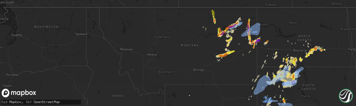
Hail Map in Montana on June 8, 2021
The weather event in Montana on June 8, 2021 includes Hail, Wind, and Tornado maps. 27 states and 374 cities were impacted and suffered possible damage. The total estimated number of properties impacted is 2,387.
Hail
Wind
Tornado
2,387
Estimated number of impacted properties by a 1.00" hail or larger1,357
Estimated number of impacted properties by a 1.75" hail or larger523
Estimated number of impacted properties by a 2.50" hail or largerStorm reports in Montana
Montana
| Date | Description |
|---|---|
| 06/08/20216:35 PM CDT | A local report indicates 2.75 inch wind near 15 N WIBAUX |
| 06/08/20216:00 PM CDT | Corrects previous hail report from 9 e glendive. Facebook photo of various hailstones and a measurement of 4 inches. |
| 06/08/20215:57 PM CDT | Mesonet station mtbvr 3.8 ne hodges |
| 06/08/20215:50 PM CDT | Still occurring... Estimating quarter size hail bouncing off ground. Some wind but not too bad. |
| 06/08/20215:49 PM CDT | Facebook comment with hail measurement. |
| 06/08/20215:49 PM CDT | Facebook comment. |
| 06/08/20215:26 PM CDT | Facebook photo of various hailstones and a measurement of 4 inches. |
| 06/08/20213:46 PM CDT | A local report indicates 2.00 inch wind near 10 SW CULBERTSON |
| 06/08/20211:30 PM CDT | Measured 1.3 inches. |
| 06/08/20214:53 AM CDT | At 952 PM MDT, severe thunderstorms were located along a line extending from 12 miles southwest of Culbertson to Lambert to 11 miles northwest of West Glendive, moving east at 45 mph. HAZARD...60 mph wind gusts and quarter size hail. SOURCE...Radar indicated. IMPACT...Hail damage to vehicles is expected. Expect wind damage to roofs, siding, and trees. Locations impacted include... Sidney, Fairview, Bainville, Bloomfield, Savage, Lambert, Intake, Snowden, Enid, Nohly, Wooley, Crane, Midway and Burns. |
| 06/08/20213:57 AM CDT | At 856 PM MDT, severe thunderstorms were located along a line extending from 20 miles east of Lustre to near Bredette to 24 miles south of Flaxville to 14 miles north of Brockton, moving northeast at 40 mph. HAZARD...60 mph wind gusts and quarter size hail. SOURCE...Radar indicated. IMPACT...Hail damage to vehicles is expected. Expect wind damage to roofs, siding, and trees. Locations impacted include... Plentywood, Scobey, Flaxville, Archer, Port Of Whitetail, Port Of Raymond, Madoc, Bredette, Redstone, Whitetail, Outlook, Raymond, Dooley, Daleview, Navajo and Antelope. |
| 06/08/20213:20 AM CDT | At 819 PM MDT, severe thunderstorms were located along a line extending from 10 miles southeast of Frazer to near Vida to 8 miles north of Brockway to 12 miles north of Miles City, moving east at 70 mph. HAZARD...60 mph wind gusts and quarter size hail. SOURCE...Radar indicated. IMPACT...Hail damage to vehicles is expected. Expect wind damage to roofs, siding, and trees. Locations impacted include... Glendive, Circle, Terry, Fallon, Richey, Savage, West Glendive, Brockway, Flowing Wells Rest Area, Intake, Bloomfield, Lambert, Vida, Lindsay, Enid, Crane, Mildred, Calypso, Midway and Hoyt. |
| 06/08/20213:07 AM CDT | At 806 PM MDT, severe thunderstorms were located along a line extending from 14 miles east of Lustre to 6 miles east of Wolf Point, moving north at 40 mph. HAZARD...60 mph wind gusts and quarter size hail. SOURCE...Radar indicated. IMPACT...Hail damage to vehicles is expected. Expect wind damage to roofs, siding, and trees. Locations impacted include... Wolf Point, Scobey, Bredette and Volt. |
| 06/08/20212:52 AM CDT | At 752 PM MDT, severe thunderstorms were located along a line extending from near Hillside to 16 miles west of Miles City, moving east at 35 mph. HAZARD...60 mph wind gusts and half dollar size hail. SOURCE...Radar indicated. IMPACT...Hail damage to vehicles is expected. Expect wind damage to roofs, siding, and trees. Locations impacted include... Rock Springs, Angela and Matthews Recreation Area. This replaces the warning previously in effect for this area. |
| 06/08/20212:48 AM CDT | At 748 PM MDT, severe thunderstorms were located along a line extending from 5 miles southeast of Colony to 4 miles southwest of Belle Fourche to 5 miles north of Black Fox Campground, moving east at 35 mph. HAZARD...60 mph wind gusts. SOURCE...Radar indicated. IMPACT...Expect damage to roofs, siding, and trees. Severe thunderstorms will be near... Belle Fourche around 755 PM MDT. Saint Onge, Brownsville and Roubaix Lake around 800 PM MDT. Fruitdale and Galena around 805 PM MDT.Other locations in the path of these severe thunderstorms includeNemo, Belle Fourche Reservoir, Nisland, Dalton Lake, Piedmont,Tilford, Arpan, Fort Meade, Summerset, Two Top Butte, Newell andVale.This includes... Interstate 90 in South Dakota between Mile Markers 1 and 53. Interstate 90 in Wyoming between Mile Markers 200 and 207. |
| 06/08/20212:45 AM CDT | At 744 PM MDT, severe thunderstorms were located along a line extending from 6 miles south of Flowing Wells Rest Area to 9 miles east of Hillside to 27 miles northeast of Forsyth, moving east at 50 mph. HAZARD...60 mph wind gusts and quarter size hail. SOURCE...Radar indicated. IMPACT...Hail damage to vehicles is expected. Expect wind damage to roofs, siding, and trees. Locations impacted include... Hillside, Mccloud and Crow Rock. |
| 06/08/20212:31 AM CDT | At 731 PM MDT, severe thunderstorms were located along a line extending from St. Marie to near Nashua to near Fort Peck to 6 miles northeast of Nelson Creek Rec Area to 6 miles southwest of Flowing Wells Rest Area, moving east at 25 mph. HAZARD...60 mph wind gusts and quarter size hail. SOURCE...Radar indicated. IMPACT...Hail damage to vehicles is expected. Expect wind damage to roofs, siding, and trees. Locations impacted include... Circle, Nashua, Fort Peck, The Pines Rec Area, Duck Creek Rec Area, Lustre, Brockway, Fort Peck Marina, Frazer, Flowing Wells Rest Area, Nelson Creek Rec Area, St. Marie, Rock Creek Rec Area, Oswego, Park Grove, Van Norman, Haxby, Weldon, Watkins and Whatley. |
| 06/08/20212:25 AM CDT | At 725 PM CDT/625 PM MDT/, a severe thunderstorm was located over Trotters, or 27 miles southeast of Sidney, moving northeast at 25 mph. This is a very dangerous storm. HAZARD...Baseball size hail and 60 mph wind gusts. SOURCE...Public. IMPACT...People and animals outdoors will be severely injured. Expect shattered windows, extensive damage to roofs, siding, and vehicles. This severe thunderstorm will remain over mainly rural areas of northern Golden Valley and southwestern McKenzie Counties, including the following locations... Sather Dam. |
| 06/08/20212:20 AM CDT | At 720 PM MDT, a severe thunderstorm was located near Wolf Point, moving northeast at 40 mph. HAZARD...60 mph wind gusts and half dollar size hail. SOURCE...Radar indicated. IMPACT...Hail damage to vehicles is expected. Expect wind damage to roofs, siding, and trees. Locations impacted include... Wolf Point, Bredette, Frazer and Oswego. |
| 06/08/20212:12 AM CDT | At 712 PM MDT, a severe thunderstorm was located 10 miles west of Flowing Wells Rest Area, or 24 miles east of Jordan, moving northeast at 30 mph. HAZARD...60 mph wind gusts and quarter size hail. SOURCE...Radar indicated. IMPACT...Hail damage to vehicles is expected. Expect wind damage to roofs, siding, and trees. Locations impacted include... Nelson Creek Rec Area, Rock Creek Rec Area, Flowing Wells Rest Area, Van Norman, Haxby and Weldon. |
| 06/08/20212:06 AM CDT | At 705 PM MDT, a severe thunderstorm was located 10 miles east of Whitewater, moving north at 50 mph. HAZARD...60 mph wind gusts and quarter size hail. SOURCE...Radar indicated. IMPACT...Hail damage to vehicles is expected. Expect wind damage to roofs, siding, and trees. Locations impacted include... Whitewater and Frenchman Reservoir. |
| 06/08/20212:02 AM CDT | At 702 PM MDT, severe thunderstorms were located along a line extending from 24 miles southwest of Cohagen to near Forsyth, moving northeast at 40 mph. HAZARD...60 mph wind gusts and half dollar size hail. SOURCE...Radar indicated. IMPACT...Hail damage to vehicles is expected. Expect wind damage to roofs, siding, and trees. Locations impacted include... Forsyth, Rosebud, Hathaway, Vananda, Rock Springs, Angela and Cartersville. |
| 06/08/20211:58 AM CDT | At 657 PM MDT, severe thunderstorms were located along a line extending from near Skaar to 9 miles southwest of Carlyle, moving northeast at 30 mph. HAZARD...Ping pong ball size hail and 60 mph wind gusts. SOURCE...Radar indicated. IMPACT...People and animals outdoors will be injured. Expect hail damage to roofs, siding, windows, and vehicles. Expect wind damage to roofs, siding, and trees. Locations impacted include... Wibaux, Carlyle, Saint Phillip and Yates. |
| 06/08/20211:53 AM CDT | At 652 PM MDT, a severe thunderstorm was located near Froid, or 14 miles north of Culbertson, moving north at 45 mph. HAZARD...Ping pong ball size hail and 60 mph wind gusts. SOURCE...Radar indicated. IMPACT...People and animals outdoors will be injured. Expect hail damage to roofs, siding, windows, and vehicles. Expect wind damage to roofs, siding, and trees. Locations impacted include... Plentywood, Medicine Lake, Froid, Archer, Outlook, Reserve, Raymond, Homestead, Dooley, Antelope and Comertown. |
| 06/08/20211:50 AM CDT | At 650 PM MDT, severe thunderstorms were located along a line extending from 9 miles northwest of Duck Creek Rec Area to near Hell Creek Rec Area, moving northeast at 45 mph. HAZARD...60 mph wind gusts and quarter size hail. SOURCE...Radar indicated. IMPACT...Hail damage to vehicles is expected. Expect wind damage to roofs, siding, and trees. Locations impacted include... Glasgow, The Pines Rec Area, Fort Peck Marina, Hell Creek Rec Area, Tampico, Duck Creek Rec Area, St. Marie and Whatley. |
| 06/08/20211:38 AM CDT | At 637 PM MDT, a severe thunderstorm was located near Frazer, or 21 miles west of Wolf Point, moving northeast at 35 mph. HAZARD...60 mph wind gusts and half dollar size hail. SOURCE...Radar indicated. IMPACT...Hail damage to vehicles is expected. Expect wind damage to roofs, siding, and trees. Locations impacted include... Lustre, Frazer, Volt and Oswego. |
| 06/08/20211:34 AM CDT | At 633 PM MDT, severe thunderstorms were located along a line extending from 6 miles southwest of Skaar to 10 miles west of Carlyle, moving northeast at 45 mph. HAZARD...Ping pong ball size hail and 60 mph wind gusts. SOURCE...Radar indicated. IMPACT...People and animals outdoors will be injured. Expect hail damage to roofs, siding, windows, and vehicles. Expect wind damage to roofs, siding, and trees. Locations impacted include... Wibaux, Carlyle, Saint Phillip and Yates. |
| 06/08/20211:24 AM CDT | At 624 PM MDT, a severe thunderstorm was located 13 miles north of Fourchette, or 26 miles east of Zortman, moving north at 30 mph. HAZARD...60 mph wind gusts and quarter size hail. SOURCE...Radar indicated. IMPACT...Hail damage to vehicles is expected. Expect wind damage to roofs, siding, and trees. This severe thunderstorm will remain over mainly rural areas of central Phillips County. |
| 06/08/20211:19 AM CDT | At 619 PM MDT, a severe thunderstorm was located near Hell Creek Rec Area, or 17 miles north of Jordan, moving north at 35 mph. HAZARD...60 mph wind gusts and half dollar size hail. SOURCE...Radar indicated. IMPACT...Hail damage to vehicles is expected. Expect wind damage to roofs, siding, and trees. Locations impacted include... Hell Creek Rec Area. |
| 06/08/20211:16 AM CDT | At 615 PM MDT, a severe thunderstorm was located 13 miles southwest of Hinsdale, or 28 miles west of Glasgow, moving north at 45 mph. HAZARD...60 mph wind gusts and quarter size hail. SOURCE...Radar indicated. IMPACT...Hail damage to vehicles is expected. Expect wind damage to roofs, siding, and trees. Locations impacted include... Whitewater, Saco, Loring, Hinsdale, Vandalia, Sleeping Buffalo, The Bentonite Plant, Frenchman Reservoir and Bowdoin. |
| 06/08/20211:00 AM CDT | At 559 PM MDT, a severe thunderstorm was located 7 miles east of The Pines Rec Area, or 28 miles south of Glasgow, moving northeast at 20 mph. HAZARD...60 mph wind gusts and quarter size hail. SOURCE...Radar indicated. IMPACT...Hail damage to vehicles is expected. Expect wind damage to roofs, siding, and trees. Locations impacted include... Nashua, Fort Peck, The Pines Rec Area, Fort Peck Marina, Duck Creek Rec Area, Rock Creek Rec Area, Haxby and Park Grove. |
| 06/08/202112:57 AM CDT | At 556 PM MDT, a severe thunderstorm was located 8 miles north of Lambert, or 23 miles west of Sidney, moving north at 45 mph. HAZARD...Ping pong ball size hail and 60 mph wind gusts. SOURCE...Radar indicated. IMPACT...People and animals outdoors will be injured. Expect hail damage to roofs, siding, windows, and vehicles. Expect wind damage to roofs, siding, and trees. Locations impacted include... Culbertson, Froid, Lambert, Mccabe, Fort Kipp and Enid. |
| 06/08/202112:32 AM CDT | At 531 PM MDT, a severe thunderstorm was located 10 miles southwest of Skaar, or 18 miles north of Wibaux, moving northeast at 30 mph. HAZARD...Ping pong ball size hail and 60 mph wind gusts. SOURCE...Radar indicated. IMPACT...People and animals outdoors will be injured. Expect hail damage to roofs, siding, windows, and vehicles. Expect wind damage to roofs, siding, and trees. Locations impacted include... Skaar. |
| 06/08/202112:11 AM CDT | At 511 PM MDT, a severe thunderstorm was located 8 miles southwest of The Pines Rec Area, or 30 miles north of Jordan, moving north at 40 mph. HAZARD...60 mph wind gusts and quarter size hail. SOURCE...Radar indicated. IMPACT...Hail damage to vehicles is expected. Expect wind damage to roofs, siding, and trees. Locations impacted include... Glasgow, Fort Peck, The Pines Rec Area, Fort Peck Marina, Hell Creek Rec Area, Tampico, Duck Creek Rec Area, Park Grove and Whatley. |
| 06/08/202112:10 AM CDT | Measure 84 mph gust on home weather station. |
| 06/07/202111:30 PM CDT | Trained spotter reported a measured wind gust of 60 mph 3 miles south of bainville. No wind damage reported. Time estimated. |
| 06/07/202111:17 PM CDT | Awos station ksdy sidney airport. Gust of 62 mph measured with 47 sustained. Two minutes earlier at 10:15pm... 53 mph sustained with gusts to 61. |
| 06/07/202111:17 PM CDT | Ndawn mesonet site has measured a 77 mph wind gust. |
| 06/07/202111:15 PM CDT | Straight line winds hit in the town of fairview. Photos include large spruce and cottonwood trees uprooted... A metal building caved in and large tree branches down. Ri |
| 06/07/202111:15 PM CDT | Corrects previous tstm wnd gst report from 2 wsw sidney. Awos station ksdy sidney airport. |
| 06/07/202111:10 PM CDT | Corrects previous tstm wnd gst report from 3 n sidney. Measure 84 mph gust on home weather station. |
| 06/07/202110:44 PM CDT | Mesonet station blum8 thoeny 1wsw/bluff creek. Time estimated. |
| 06/07/202110:10 PM CDT | Corrects previous hail report from 7 ne wolf point. 60 mph winds as well. |
| 06/07/20219:55 PM CDT | Spotter report 1.12 inches of rainfall... No hail. Wind damage observed to a few shingles and the soffit broke loose. No major tree or crop damage observed so far. Time |
| 06/07/20219:25 PM CDT | Some flash flooding of lowlands. Severe winds and heavy rain lasted from 7:55 to 8:40 pm. |
| 06/07/20219:20 PM CDT | Mesonet station 07mt 1.0 ne saint marie |
| 06/07/20219:15 PM CDT | With nickle-sized hail. |
| 06/07/20219:00 PM CDT | Nickle to quarter size hail. |
| 06/07/20219:00 PM CDT | A local report indicates 1.75 inch wind near 9 SE VAN NORMAN |
| 06/07/20218:56 PM CDT | Asos station kolf wolf point airport. Recorded at 7:48pm... 7:53pm and 7:56pm. Sustained winds up to 49 mph with all but one observation in the last 15 minutes over 40 |
| 06/07/20218:54 PM CDT | Wolf point airport. |
| 06/07/20218:53 PM CDT | Asos station kggw glasgow airport |
| 06/07/20218:30 PM CDT | Facebook photos from in town- at least golf ball size hail. |
| 06/07/20218:23 PM CDT | Awos station ksdy sidney airport. |
| 06/07/20218:16 PM CDT | A local report indicates 1.75 inch wind near OSWEGO |
| 06/07/20218:15 PM CDT | No hail 0.6 to 0.7 inches rain. |
| 06/07/20218:15 PM CDT | A local report indicates 1.75 inch wind near HELL CREEK REC AREA |
| 06/07/20218:00 PM CDT | Pea sized hail as well. |
| 06/07/20217:50 PM CDT | Facebook message with photo. Size of hail estimated to be 1.5 inches. |
| 06/07/20217:35 PM CDT | Corrects previous hail report from fort kipp. Occurred 1 hour earlier than previously reported. Facebook photos from in town- at least golf ball size hail. |
| 06/07/20217:30 PM CDT | Golfball to tennis ball hail off and on from 630-715 pm. |
| 06/07/20217:23 PM CDT | Outflow from cluster of storms to east. |
| 06/07/20217:18 PM CDT | A local report indicates 1.75 inch wind near 8 SSE FORT KIPP |
| 06/07/20217:05 PM CDT | Twitter photo with measurement of baseball size hail. |
| 06/07/20217:00 PM CDT | A local report indicates 2.00 inch wind near 10 SW CULBERTSON |
All States Impacted by Hail Map on June 8, 2021
Cities Impacted by Hail Map on June 8, 2021
- Merrill, WI
- Fe Warren Afb, WY
- Cheyenne, WY
- Winsted, CT
- Pine Bluffs, WY
- Bushnell, NE
- Pelican Lake, WI
- New England, ND
- Timber Lake, SD
- Forsyth, MT
- Rosebud, MT
- Flasher, ND
- McIntosh, SD
- Hettinger, ND
- Lemmon, SD
- Regent, ND
- Fort Peck, MT
- Brockton, MT
- Glendive, MT
- Foster City, MI
- Sturgis, SD
- Piedmont, SD
- Kadoka, SD
- Seney, MI
- Hermosa, SD
- Rapid City, SD
- Caputa, SD
- Paradise, MI
- Lantry, SD
- Dupree, SD
- Bison, SD
- Prairie City, SD
- Frazer, MT
- Wolf Point, MT
- Bowman, ND
- Goshen, AL
- Coffeeville, AL
- Jackson, AL
- Fairview, MT
- Wibaux, MT
- Cartwright, ND
- Beach, ND
- Bloomfield, MT
- Savage, MT
- Froid, MT
- Culbertson, MT
- Richey, MT
- Lambert, MT
- Jamestown, ND
- Carson, ND
- Center, ND
- Keystone, SD
- Ellsworth Afb, SD
- Custer, SD
- Box Elder, SD
- Tappen, ND
- Cohagen, MT
- Brockway, MT
- Circle, MT
- Gleason, WI
- Dickinson, ND
- Lefor, ND
- Gladstone, ND
- Meadow, SD
- Malta, MT
- Elgin, ND
- Glen Ullin, ND
- Long Lake, WI
- Fairfield, ND
- Cleveland, ND
- Medina, ND
- Isabel, SD
- Woodstown, NJ
- Salem, NJ
- Palmer, MI
- Negaunee, MI
- Thief River Falls, MN
- Braddock, ND
- Hazelton, ND
- Rice Lake, WI
- Deerbrook, WI
- Oakfield, GA
- Sagola, MI
- Belle Fourche, SD
- Norway, MI
- Niagara, WI
- Dunbar, WI
- Quinnesec, MI
- Pembine, WI
- Alzada, MT
- Viking, MN
- Argyle, MN
- Barron, WI
- Jordan, MT
- McLaughlin, SD
- Newell, SD
- Mud Butte, SD
- Watauga, SD
- Reva, SD
- Eagle Butte, SD
- Trail City, SD
- Selfridge, ND
- Faith, SD
- Keldron, SD
- Morristown, SD
- Buffalo Gap, SD
- Fairburn, SD
- Dawson, ND
- Kintyre, ND
- Steele, ND
- Linton, ND
- Driscoll, ND
- Moffit, ND
- Wing, ND
- Raleigh, ND
- Hot Springs, SD
- Germfask, MI
- Hinsdale, MT
- Buffalo, SD
- Camp Crook, SD
- Wall, SD
- Wausau, WI
- Phillips, WI
- Valentine, NE
- Westboro, WI
- Medford, WI
- Laona, WI
- Cameron, WI
- Shields, ND
- Big Springs, NE
- Brinson, GA
- Colquitt, GA
- Bainbridge, GA
- Edgemont, SD
- Carbon Hill, AL
- Belfield, ND
- Mott, ND
- Gwinn, MI
- Republic, MI
- Channing, MI
- Champion, MI
- New Underwood, SD
- Butler, AL
- Needham, AL
- Ripon, WI
- Saco, MT
- Pine Ridge, SD
- Enning, SD
- Andersonville, GA
- Americus, GA
- Leary, GA
- Fort Yates, ND
- Cannon Ball, ND
- Solen, ND
- Leesburg, GA
- Smithville, GA
- Antigo, WI
- Ishpeming, MI
- New Leipzig, ND
- Quinn, SD
- Skandia, MI
- Felch, MI
- Elmer, NJ
- Monroeville, NJ
- Nashua, MT
- Sidney, MT
- Armstrong Creek, WI
- Winter, WI
- Three Lakes, WI
- Eagle River, WI
- Chappell, NE
- Staten Island, NY
- Marquette, MI
- Lance Creek, WY
- Tuckerton, NJ
- Egg Harbor City, NJ
- Chatsworth, NJ
- Vincentown, NJ
- Ojibwa, WI
- Lodgepole, NE
- Saugerties, NY
- Catskill, NY
- Montgomery, AL
- Hope Hull, AL
- Rhinelander, WI
- Iron River, MI
- Colebrook, CT
- Norfolk, CT
- Hogansville, GA
- Phelps, WI
- Damascus, GA
- Clifford, MI
- Burns, WY
- Upton, WY
- Elcho, WI
- Iron Mountain, MI
- Tripoli, WI
- Brilliant, AL
- Winfield, AL
- Guin, AL
- Ladysmith, WI
- West Chester, PA
- Kennett Square, PA
- Prentice, WI
- Woodcliff Lake, NJ
- Hillsdale, NJ
- Westwood, NJ
- Dawson, GA
- Howes, SD
- Summit Lake, WI
- Argonne, WI
- Crookston, MN
- Red Lake Falls, MN
- Aladdin, WY
- Alva, WY
- Hulett, WY
- Black Hawk, SD
- Dorchester, WI
- Abbotsford, WI
- Newberry, MI
- Marshall, VA
- Hume, VA
- Park Falls, WI
- Ellaville, GA
- Township Of Washington, NJ
- Park Ridge, NJ
- Harrington Park, NJ
- Emerson, NJ
- Tony, WI
- Cody, WY
- Philip, SD
- Reynolds, GA
- Medora, ND
- Regan, ND
- Baldwin, ND
- Florida, NY
- Chester, NY
- Goshen, NY
- Amidon, ND
- East Orange, NJ
- Newark, NJ
- New Salem, ND
- Stanton, ND
- Crystal Falls, MI
- Poplar, MT
- Terry, MT
- Hawkins, WI
- Mission, SD
- Lusk, WY
- Angela, MT
- Kinsey, MT
- Bronwood, GA
- Plains, GA
- Elko, GA
- Warren, MN
- Fort Monmouth, NJ
- Eatontown, NJ
- Otisville, MI
- Olivebridge, NY
- Ackerman, MS
- Weir, MS
- Newcastle, WY
- Belmar, NJ
- Spring Lake, NJ
- Sundance, WY
- Thorp, WI
- McMillan, MI
- Birmingham, MI
- Vulcan, MI
- Saint Francis, SD
- Marianna, FL
- Cottondale, FL
- Athelstane, WI
- Conowingo, MD
- Hysham, MT
- Sanders, MT
- Glen Flora, WI
- Bloomfield Hills, MI
- Pontiac, MI
- McGehee, AR
- Tillar, AR
- Carpenter, WY
- Irma, WI
- Franklin, AL
- Ainsworth, NE
- Brantwood, WI
- Wanblee, SD
- Millville, MA
- Oglethorpe, GA
- Lac Du Flambeau, WI
- Woodworth, ND
- Pettibone, ND
- Demopolis, AL
- Wabeno, WI
- Manville, WY
- Hammonton, NJ
- Yale, MI
- Melvin, MI
- Columbiaville, MI
- Macon, MS
- Newport, TN
- Franklin, GA
- Tifton, GA
- Ty Ty, GA
- Omega, GA
- New Brockton, AL
- Kyle, SD
- Ogema, WI
- Moorcroft, WY
- Bloomer, WI
- Williamstown, NJ
- Franklinville, NJ
- Brokaw, WI
- Warwick, NY
- Glenwood, NJ
- Vernon, NJ
- Hawkinsville, GA
- Ocilla, GA
- Fitzgerald, GA
- Kingsford, MI
- Douglas, MA
- Middletown, NY
- Montgomery, NY
- Shreve, OH
- Wisdom, MT
- Swiftwater, PA
- Mount Pocono, PA
- Carteret, NJ
- Irvington, NJ
- Vauxhall, NJ
- Springfield, NJ
- Elizabeth, NJ
- Maplewood, NJ
- Millburn, NJ
- Hillside, NJ
- Union, NJ
- Hazen, ND
- Beulah, ND
- Shawnee, WY
- Tuttle, ND
- Douglas, WY
- Livermore, CO
- Alvarado, MN
- Meridian, MS
- Collinston, LA
- West Monroe, LA
- Columbia, LA
- Monroe, LA
- Mangham, LA
- Rayville, LA
- Oak Ridge, LA
- Williston, ND
- Bainville, MT
- Trenton, ND
- Lost Springs, WY
- Hillsdale, WY
- Patoka, IN
- Little Eagle, SD
- Wakpala, SD
- Glencross, SD
- Spearfish, SD
- Nisland, SD
- Saint Onge, SD
- Beulah, WY
- Deadwood, SD
- Nemo, SD
- Owanka, SD
- Wasta, SD
- Scenic, SD
- Belvidere, SD
- Interior, SD
- Tyler, TX
- Reklaw, TX
- Whitewater, MT


