Hail Map on May 17, 2023
The weather event on May 17, 2023 includes Hail map. 16 states and 234 cities were impacted and suffered possible damage. The total estimated number of properties impacted is 8,928.
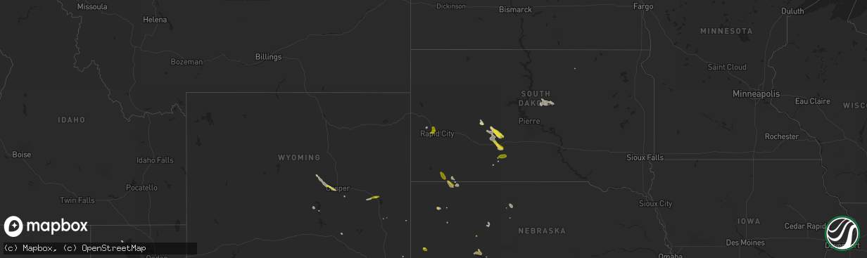
Hail
8,928
Estimated number of impacted properties by a 1.00" hail or larger32
Estimated number of impacted properties by a 1.75" hail or larger0
Estimated number of impacted properties by a 2.50" hail or largerStates Impacted by Hail Map on May 17, 2023
Storm reports
South Dakota
| Date | Description |
|---|---|
| 05/17/20234:46 PM CDT | A local report indicates 60 MPH wind near BELVIDERE |
| 05/17/20233:22 PM CDT | A local report indicates 1.00 inch wind near 10 ESE OELRICHS |
| 05/17/20232:13 PM CDT | A local report indicates 1.00 inch wind near BLACK HAWK |
| 05/17/20231:50 PM CDT | A local report indicates 1.00 inch wind near 5 NW DWTN RAPID CITY |
Nebraska
| Date | Description |
|---|---|
| 05/17/20234:20 PM CDT | Quarter size hail with 60 mph wind gusts. |
Colorado
| Date | Description |
|---|---|
| 05/16/20237:45 PM CDT | Ongoing quarter sized hail reported. |
Texas
| Date | Description |
|---|---|
| 05/17/20236:50 PM CDT | Report with picture from twitter. |
| 05/17/20236:43 PM CDT | Report from mping: half dollar |
| 05/16/20238:32 PM CDT | Picture from twitter. Hail was measured at 1.36 inches. |
| 05/16/20237:28 PM CDT | Hail size estimated based on picture from twitter. |
Arizona
| Date | Description |
|---|---|
| 05/17/20234:45 PM CDT | A local report indicates 1.50 inch wind near 5 N WALKER |
| 05/17/20233:55 PM CDT | From report on facebook. |
| 05/16/20238:01 PM CDT | Asos station ksad safford regional airport. |
Mississippi
| Date | Description |
|---|---|
| 05/17/20235:08 PM CDT | Viewer photos of nickel to quarter size hail in waynesboro. Report relayed via nwschat. |
Georgia
| Date | Description |
|---|---|
| 05/17/20231:34 PM CDT | Trees down on rolling hills road. Time estimated by radar. |
| 05/17/20231:30 PM CDT | Powerlines down in barwick at clifford and coffee streets. Time estimated by radar. |
South Carolina
| Date | Description |
|---|---|
| 05/17/20234:50 PM CDT | South carolina department of natural resources reported a tree down at dnr outdoor classroom. Pictures indicate tree was heavily rotted. |
| 05/17/20234:40 PM CDT | Meeting street and cumberland street. Hail lasted for about 10 minutes. |
Florida
| Date | Description |
|---|---|
| 05/17/20233:35 PM CDT | A tree was blown down at dyal road and us highway 1 nw of callahan. The time of damage was based on radar. |
| 05/17/20232:15 PM CDT | Wind gusts from a thunderstorm estimated around 36 kts/41 mph damaged outdoor furniture and caused some tree damage in the area. |
| 05/17/20231:50 PM CDT | Two trees were blown down across i-75 at mile marker 467. The time of damage was based on radar imagery. |
| 05/17/20231:50 PM CDT | Corrects previous tstm wnd dmg report from 1 wsw jennings. A trees was blown down across 2 lanes of i-75 at mile marker 467. The time of damage was based on radar image |
| 05/17/20231:20 PM CDT | Severe storm winds caused damage to utility equipment on little talbot island. The time of damage was based on radar imagery. |
| 05/17/20231:20 PM CDT | Corrects previous tstm wnd dmg report from 2 wnw mayport. Restaurant along the st. Johns river reports electronic sign blown over and smashed. Time estimated from radar |
| 05/17/20231:15 PM CDT | Restaurant along the st. Johns river reports electronic sign blown over and smashed. Time estimated from radar. |
| 05/17/202312:49 PM CDT | Fhp reports trees down on interstate 10 at mile marker 246... Blocking eastbound travel lanes. Time estimated by radar. |
| 05/17/202311:37 AM CDT | Tree down on martin luther king blvd. Time estimated by radar. |
| 05/17/202311:35 AM CDT | Tree down on fulton harvey road. Time estimated by radar. |
| 05/17/202311:34 AM CDT | Public report of tree down on harvey mill road at mill hollow drive. Time estimated by radar. |
| 05/17/202311:32 AM CDT | Powerlines down in quincy. Time estimated by radar. |
Kansas
| Date | Description |
|---|---|
| 05/16/20239:00 PM CDT | Estimated 50-60 mph wind gusts with pea sized hail. |
Wyoming
| Date | Description |
|---|---|
| 05/17/20233:15 PM CDT | A trained spotter reported quarter size hail. |
Alabama
| Date | Description |
|---|---|
| 05/17/20232:55 PM CDT | Em reports trees down along zimco rd about a mile or 2 north of winn rd. Time estimated using radar. |
| 05/17/20232:24 PM CDT | Em reports from 911 call center few trees down along brooksville rd a couple miles west of old line rd |
| 05/17/20232:12 PM CDT | Corrects previous tstm wnd dmg report from jackson. Em reports tree down on a powerline at the intersection of forest ave & golf view dr. Time estimated on radar. Corre |
| 05/17/20232:11 PM CDT | Em reports large tree down along hwy 10 w a few miles east of yellow bluff... Al. |
| 05/17/20232:10 PM CDT | Corrects previous tstm wnd dmg report from jackson. Em reports a large tree down near 350 commerce st close to vanity park. Corrected time from 1:10 pm to 2:10pm. |
| 05/17/20232:10 PM CDT | Em reports minor tree limb debris scattered across the area near industrial dr & 177. |
| 05/17/20231:55 PM CDT | Numerous trees reported down around roanoke. |
| 05/17/20231:12 PM CDT | Em reports tree down on a powerline at the intersection of forest ave & golf view dr. Time estimated on radar. |
| 05/17/20231:10 PM CDT | Em reports a large tree down near 350 commerce st close to vanity park. |
Cities Impacted by Hail Map on May 17, 2023
- Rapid City, SD
- Black Hawk, SD
- Piedmont, SD
- Casper, WY
- Hay Springs, NE
- Prescott, AZ
- Dewey, AZ
- Belvidere, SD
- White River, SD
- Long Valley, SD
- Kadoka, SD
- Norris, SD
- Midland, SD
- Douglas, WY
- Shawnee, WY
- Pritchett, CO
- Springfield, CO
- Roscoe, TX
- Maryneal, TX
- Las Animas, CO
- Kim, CO
- Venango, NE
- Imperial, NE
- Champion, NE
- Miami, TX
- Pampa, TX
- Payson, AZ
- Parks, NE
- Benkelman, NE
- Haigler, NE
- Vernon, CO
- Wray, CO
- Saint Francis, KS
- Idalia, CO
- Harrisburg, NE
- Hooker, OK
- Tyrone, OK
- Liberal, KS
- Hugoton, KS
- Oelrichs, SD
- Charleston, SC
- Groom, TX
- Elberta, AL
- Lucedale, MS
- Leakesville, MS
- Skipperville, AL
- Ozark, AL
- Bushnell, NE
- Mission, TX
- Aguilar, CO
- Walsenburg, CO
- Reynolds, GA
- Troy, AL
- Kanorado, KS
- Goodland, KS
- Jack, AL
- Alliance, NE
- Citronelle, AL
- Eastman, GA
- Whitman, NE
- Crook, CO
- Petal, MS
- Vancleave, MS
- Waynesboro, MS
- Wheatland, WY
- Hermleigh, TX
- Moss Point, MS
- Lake Park, GA
- McLain, MS
- Nemo, SD
- Holabird, SD
- Highmore, SD
- Onida, SD
- Weatherford, OK
- Julesburg, CO
- Brule, NE
- Big Springs, NE
- Coahoma, TX
- Bush, LA
- Flagler Beach, FL
- Hemingford, NE
- Pine Ridge, SD
- Covington, LA
- Abita Springs, LA
- Merriman, NE
- Monticello, FL
- Dublin, GA
- Keystone, NE
- Blackwell, TX
- Shubuta, MS
- Quitman, MS
- Vossburg, MS
- Milesville, SD
- Philip, SD
- Beaver, OK
- Butler, GA
- Seminole, AL
- Valentine, NE
- Gulfport, MS
- Pine Bluffs, WY
- Millry, AL
- Laurel Hill, FL
- Rutledge, AL
- Carpenter, WY
- Wiggins, MS
- Grouse Creek, UT
- Thomasville, AL
- Lower Peach Tree, AL
- Pine Hill, AL
- Angie, LA
- Hollywood, FL
- Heidelberg, MS
- Laurel, MS
- Lewellen, NE
- Lemoyne, NE
- Chadron, NE
- Lillian, AL
- Grand Bay, AL
- Turpin, OK
- Torrington, WY
- Eufaula, AL
- San Perlita, TX
- Hyannis, NE
- Cape Canaveral, FL
- Patrick Afb, FL
- San Benito, TX
- Brownsville, TX
- Cochran, GA
- Wing, AL
- McIntosh, AL
- Bayard, NE
- Snyder, TX
- Jupiter, FL
- Palm Beach Gardens, FL
- Merritt Island, FL
- Cresbard, SD
- Morrill, NE
- Enterprise, AL
- Wagarville, AL
- Rushville, NE
- Mcallen, TX
- Gainestown, AL
- Burns, WY
- Coffeeville, AL
- Jackson, AL
- Tibbie, AL
- Panhandle, TX
- Grover, CO
- Loraine, TX
- Sunshine, LA
- Saint Gabriel, LA
- Baton Rouge, LA
- Irvington, AL
- Yulee, FL
- Havana, FL
- Melbourne, FL
- Sturgis, SD
- Georgiana, AL
- Pine Apple, AL
- Oshkosh, NE
- Arthur, NE
- Mullen, NE
- Linden, AL
- New Iberia, LA
- Pima, AZ
- Mount Vernon, AL
- Thatcher, AZ
- Martin, SD
- New Brockton, AL
- Ariton, AL
- Flagstaff, AZ
- Theodore, AL
- Goshen, AL
- Ira, TX
- Hollywood, SC
- Ravenel, SC
- Fort Lauderdale, FL
- Saint Francis, SD
- Ovett, MS
- Richton, MS
- Edinburg, TX
- Mobile, AL
- Saraland, AL
- Birmingham, AL
- Thomasville, GA
- Arabi, LA
- Fernandina Beach, FL
- Cheyenne, WY
- Cairo, GA
- Ipswich, SD
- Adams Run, SC
- Wood, SD
- Deer Park, AL
- Trussville, AL
- Mount Pleasant, SC
- Frisco City, AL
- Chattahoochee, FL
- Ashby, NE
- Fargo, GA
- Los Fresnos, TX
- Montezuma, GA
- Perry, GA
- Marshallville, GA
- Mayo, FL
- Grant, NE
- Robertsdale, AL
- Coden, AL
- Rio Hondo, TX
- Deadwood, SD
- Waverly Hall, GA
- Shiloh, GA
- Franklinton, LA
- Bogalusa, LA
- Chalmette, LA
- Buckatunna, MS
- Hahira, GA
- Palm Bay, FL
- Seneca, NE
- Vinegar Bend, AL
- Dexter, GA
- Dudley, GA
- Campbell, AL
- Sheridan Lake, CO
- Fort Rucker, AL
- Mitchell, NE
- Livingston, LA
- Walker, LA
- Waynesboro, GA
- Leroy, AL
- Stevenson, WA
- Stringer, MS
- Bay Springs, MS
- Pharr, TX
- Hidalgo, TX