Hail Map on May 12, 2024
The weather event on May 12, 2024 includes Hail map. 9 states and 296 cities were impacted and suffered possible damage. The total estimated number of properties impacted is 208,310.
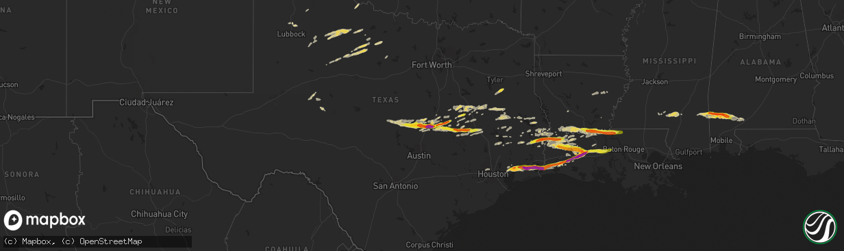
Hail
208,310
Estimated number of impacted properties by a 1.00" hail or larger126,132
Estimated number of impacted properties by a 1.75" hail or larger28,064
Estimated number of impacted properties by a 2.50" hail or largerStates Impacted by Hail Map on May 12, 2024
Storm reports
Texas
| Date | Description |
|---|---|
| 05/12/20246:40 PM CDT | Several trees blown down. Witnesses say it was a possible tornado. |
| 05/12/20246:21 PM CDT | Reports of multiple flooded locations on fm 252. |
| 05/12/20246:15 PM CDT | Resident reports several trees blown down due to possible tornado. Trees damaged a home. |
| 05/12/20243:30 PM CDT | Multiple trees blown down. |
| 05/12/20242:30 PM CDT | Report received from mping. |
| 05/12/20242:26 PM CDT | Report received from mping. |
| 05/12/20242:01 PM CDT | Photo received of golf ball size hail at bleakwood. |
| 05/12/20241:20 PM CDT | Hail from golfball to hen egg size reported at groves. |
| 05/12/20241:18 PM CDT | Call from the public about 3/4 to quarter sized hail. |
| 05/12/20241:13 PM CDT | Report from mping: quarter |
| 05/12/20241:11 PM CDT | Helicopter spun around and a boarding stairway was blown down the tarmac. The asos had winds 22g56mph before the sensor stopped reporting for about 10 minutes. Higher w |
| 05/12/202412:45 PM CDT | Video of ping pong ball size hail at fannett. |
| 05/12/202412:38 PM CDT | Several pictures from the public and media of large hail north of hampshire. |
| 05/12/202412:15 PM CDT | Picture of hailstone roughly the size of an egg reported on social media. |
| 05/12/202410:49 AM CDT | Report from mping: half dollar |
| 05/12/202410:28 AM CDT | Photo shared of quarter hail in franklin. Time estimated from radar. |
| 05/12/202410:10 AM CDT | Photo of quarter hail on social media. |
| 05/12/20249:54 AM CDT | Delayed report from mping half dollar |
| 05/12/20249:27 AM CDT | Delayed report - hail up to golf ball size reported in temple. |
| 05/12/20249:20 AM CDT | Photo of 2 inch hail in south temple - delayed report. |
| 05/12/20249:12 AM CDT | Wide swath of tree damage reported near tx317 and old waco rd including trees snapped and fencing blown down. |
| 05/12/20249:08 AM CDT | Delayed report - photo of golf ball to egg size hail from belton. |
| 05/12/20249:07 AM CDT | Delayed report from mping: half dollar |
| 05/12/20249:06 AM CDT | Delayed report - hail up to golf balls reported in belton. |
| 05/12/20248:50 AM CDT | Delayed report - penny to quarter hail reported in harker heights. |
| 05/12/20248:46 AM CDT | Delayed report - ping pong size hail reported in cedar spring. |
| 05/12/20248:43 AM CDT | Delayed report - quarter hail reported on the south side of killeen. |
| 05/12/20248:33 AM CDT | Delayed report from mping: quarter |
| 05/12/20244:00 AM CDT | Homeowner called to report wind damage at her residence. Trees were snapped between her and neighbors. Mentioned twisted cedar trees... Lots of debris all over the plac |
Oklahoma
| Date | Description |
|---|---|
| 05/12/20246:00 PM CDT | Hail up to quarter size. Picture via social media. |
| 05/12/20245:53 PM CDT | Report from mping. |
| 05/12/20245:16 PM CDT | Via spotter network. |
| 05/12/20245:00 PM CDT | Mentions off possibly bigger hail stones present. |
| 05/12/20244:35 PM CDT | Hail covering the highway at the intersection of highways 64 and 95. Most hail was about nickel size with the largest being golfball size. Report/video via social media |
| 05/12/20242:20 PM CDT | [landspout] picture of a landspout near the intersection of highways 64 and 95... Also known as the four corners region of texas county. |
| 05/12/20242:07 PM CDT | [landspout] multiple reports and pictures of a landspout to the south of keyes. |
| 05/12/20244:34 AM CDT | A home experienced partial loss of its roof from a tornado. |
Nebraska
| Date | Description |
|---|---|
| 05/12/20245:45 PM CDT | [landspout] multiple reports and video of landspout tornado. |
Louisiana
| Date | Description |
|---|---|
| 05/12/20246:05 PM CDT | Corrects previous hail report from 1 sse bunkie. Several photos and public reports of hail in and south of bunkie. Largest reported size of 1.50 inches. |
| 05/12/20245:17 PM CDT | A few reports of wind damage in the area. A trampoline flipped... A power pole bent... And a barn destroyed. |
| 05/12/20244:22 PM CDT | Photos of different sized hail in the church point area. Largest size appears to be around an inch. |
| 05/12/20243:49 PM CDT | Public report of 2.00 inch hail at iota. |
| 05/12/20243:45 PM CDT | A few branches down along with a tree down on a truck. |
| 05/12/20243:43 PM CDT | Report from mping: hen egg+ |
| 05/12/20243:40 PM CDT | Pulbic sent several photos of large hail. Largest estimated size of near 2 1/4. |
| 05/12/20243:39 PM CDT | Public reports golf ball size hail at iota. |
| 05/12/20243:35 PM CDT | Photo of hen egg size hail falling at jennings. |
| 05/12/20243:32 PM CDT | Report of hail at 1.00 inch falling in jennings. |
| 05/12/20243:30 PM CDT | Report from mping: golf ball |
| 05/12/20243:30 PM CDT | Photo of 2.50 inch hail in downtown jennings. |
| 05/12/20243:23 PM CDT | Photos submitted of large hail and a ruler. Looks to be a little less than 2.50 inches. |
| 05/12/20243:16 PM CDT | Golf ball size hail reported at 3:16pm over bell city area. |
| 05/12/20243:04 PM CDT | Report from public of trampolines flipped... Telephone poles bent over road... Many trees snapped. Public reports marble size hail on ground at time of report given to |
| 05/12/20243:02 PM CDT | Corrects previous tstm wnd dmg report from ragley. A few reports of wind damage in the area. A trampoline flipped... A power pole bent... And a barn destroyed. |
| 05/12/20242:59 PM CDT | Public reports large hail to ping pong ball size was blown into the side of their camper resulting in windows being destroyed. |
| 05/12/20242:59 PM CDT | Public reports multiple trees down and power outages in the ragley community. Large hail destroyed windows. |
| 05/12/20242:37 PM CDT | Nws employee reports golf ball size hail. |
| 05/12/20241:05 PM CDT | Several photos and public reports of hail in and south of bunkie. Largest reported size of 1.50 inches. |
| 05/12/202412:32 AM CDT | Significant damage across the southern part of the parish... Located around wisner. Large amounts of old and mobile homes damaged. Various large trees uprooted... With |
Wisconsin
| Date | Description |
|---|---|
| 05/12/20244:40 PM CDT | Large tree branch broken with photo submitted. Report of trees down near raymond road. Relayed via wisc tv. Time estimated from radar. |
| 05/12/20244:34 PM CDT | Report of trees down. No specific location given at this time. Time estimated from radar. |
| 05/12/20244:25 PM CDT | Report of trees down. No specific location given at this time. Time estimated from radar. |
| 05/12/20244:25 PM CDT | Report of trees down. No specific location given at this time. Time estimated from radar. |
Colorado
| Date | Description |
|---|---|
| 05/12/20244:30 PM CDT | [landspout] |
| 05/12/20243:05 PM CDT | [landspout] colorado storm chasers photo. Time and location estimated. |
| 05/12/20242:30 PM CDT | Picture of landspout taken west of lamar. |
| 05/12/20242:30 PM CDT | [landspout] corrects previous tornado report from 3 wnw mcclave. Picture of landspout taken west of lamar. |
Alabama
| Date | Description |
|---|---|
| 05/12/20246:13 AM CDT | Emergency management reports golf ball size hail in the rockville community. |
| 05/12/20246:10 AM CDT | Multiple trees down in the mcintosh community. Time estimated by radar. |
| 05/12/20246:00 AM CDT | Multiple reports of golf ball size hail in the wagarville and sunflower communities. Time estimated on radar. |
| 05/12/20245:47 AM CDT | Multiple trees down in chatom... Al. Time estimated by radar. |
| 05/12/20245:41 AM CDT | Two mobile homes damaged by trees in frankville... Al. |
Kansas
| Date | Description |
|---|---|
| 05/12/20246:15 PM CDT | Report from mping: quarter |
| 05/11/20247:38 PM CDT | [landspout] |
Mississippi
| Date | Description |
|---|---|
| 05/12/20244:50 AM CDT | Multiple large limbs and small trees down with a large limb puncturing a roof. |
| 05/12/20244:48 AM CDT | Several trees down on jim brownlee rd. Time estimated by radar. |
| 05/12/20244:41 AM CDT | Small trees and large limbs down in the area. One tree punctured the roof of a home. Report relayed via nws mobile. |
| 05/12/20244:39 AM CDT | Tree down on a house on show road with one injury reported. |
| 05/12/20244:38 AM CDT | This swath of significant straight line winds started near the leaf river and moved generally ese. Heaviest damage was along highway 11 and then again along leeville ne |
| 05/12/20244:37 AM CDT | Multiple trees down in the leeville and petal areas. |
| 05/12/20244:35 AM CDT | This swath of wind started on the south side of petal near boxtel street and crabapple drive and moved sse across carterville road into the carterville community. Initi |
| 05/12/20244:31 AM CDT | Several trees damaged to the east of hwy 49. |
| 05/12/20244:30 AM CDT | Several trees reported down at 6419 old highway 42. |
| 05/12/20244:27 AM CDT | Several trees down in the northern part of the county. |
| 05/12/20244:25 AM CDT | Trees down. |
| 05/12/20244:25 AM CDT | Tree down on a house on 16th ave. |
| 05/12/20244:23 AM CDT | Tin canopy collapsed at a sonic drive-thru off old hwy 11. |
| 05/12/20244:20 AM CDT | Corrects previous tstm wnd dmg report from 3 n bellevue. Several trees reported down at 6419 old highway 42. |
| 05/12/20244:18 AM CDT | Trees down on county road 23. Time estimated based on radar. |
| 05/12/20244:15 AM CDT | Trees down on highway 15. Time estimated based on radar. |
| 05/12/20244:15 AM CDT | Lot of trees & debris down on hwy 44 in sumrall. |
| 05/12/20244:10 AM CDT | Corrects previous tstm wnd dmg report from 1 nw shady grove. Trees down on highway 15 and county road 8. Time estimated based on radar. |
| 05/12/20244:07 AM CDT | Report of trees downed on highway 533 in southern jasper county. Time estimated based on radar. |
| 05/12/20244:02 AM CDT | Multiple trees down in the improve community. |
| 05/12/20244:00 AM CDT | Multiple trees down around bassfield and hwy 35 s areas. |
| 05/12/20243:57 AM CDT | Multiple trees down and power lines... Roads blocked around the bunker hill community and hwy 35. |
| 05/12/20243:55 AM CDT | Numerous trees down. |
| 05/12/20243:55 AM CDT | Leaf valley veterinarian clinic lost roof. |
| 05/12/20243:53 AM CDT | Multiple trees down in the society hill community. |
| 05/12/20243:53 AM CDT | Numerous trees down... Many across roads... Including hwy 44 and 13 n. |
| 05/12/20243:50 AM CDT | Multiple downed trees in the oak vale area. |
| 05/12/20243:33 AM CDT | Report of trees down on highway 27s. Time estimated based on radar. |
| 05/12/20243:30 AM CDT | Reports of trees down on both holmesville road and robert tynes road. Time estimated based on radar. |
| 05/12/20243:30 AM CDT | Reports of trees down on both holmesville road and robert tynes road. One resident was trapped in a trailer on robert tynes road. Time estimated based on radar. |
| 05/12/20243:10 AM CDT | Tree uprooted. |
| 05/12/20242:02 AM CDT | Trees and powerlines were down in natchez. Additional trees and powerlines were down across the county. |
| 05/12/20241:13 AM CDT | Trees down in port gibson. |
| 05/12/20241:10 AM CDT | Trees down on grand gulf road. |
Cities Impacted by Hail Map on May 12, 2024
- Quitaque, TX
- San Saba, TX
- Salado, TX
- Clarendon, TX
- Lometa, TX
- Post, TX
- Dickens, TX
- Paducah, TX
- Killeen, TX
- Hedley, TX
- Lakeview, TX
- Justiceburg, TX
- Belton, TX
- Fort Hood, TX
- Crosbyton, TX
- Spur, TX
- Lampasas, TX
- Temple, TX
- Burlington, TX
- Rogers, TX
- Lockney, TX
- Troy, TX
- Memphis, TX
- Wellington, TX
- Rosebud, TX
- Gatesville, TX
- Lott, TX
- Quail, TX
- Kempner, TX
- Copperas Cove, TX
- Rotan, TX
- Moody, TX
- Haskell, TX
- Hermleigh, TX
- Reagan, TX
- Eddy, TX
- Harker Heights, TX
- Nolanville, TX
- Marlin, TX
- Hammon, OK
- Cheyenne, OK
- Throckmorton, TX
- Chilton, TX
- Bremond, TX
- Broaddus, TX
- Quanah, TX
- Newcastle, TX
- Little River Academy, TX
- Hamlin, TX
- Aspermont, TX
- Bronson, TX
- Pineland, TX
- Centerville, TX
- Normangee, TX
- Jewett, TX
- Olney, TX
- Marquez, TX
- Rule, TX
- Childress, TX
- Thornton, TX
- Kosse, TX
- Stamford, TX
- Crowell, TX
- Seymour, TX
- Dodson, TX
- Groesbeck, TX
- Cameron, TX
- Calvert, TX
- Hollis, OK
- Houston, TX
- Goree, TX
- Weinert, TX
- Buckholts, TX
- Hearne, TX
- Franklin, TX
- Vinson, OK
- Mangum, OK
- Breckenridge, TX
- Graham, TX
- South Bend, TX
- Willow, OK
- Apple Springs, TX
- Kennard, TX
- North Zulch, TX
- Bryan, TX
- Madisonville, TX
- Lorena, TX
- Lufkin, TX
- Deer Park, TX
- Huntington, TX
- Midway, TX
- Dayton, TX
- Baytown, TX
- Liberty, TX
- Wallisville, TX
- Devers, TX
- Hankamer, TX
- New Waverly, TX
- Coldspring, TX
- Cleveland, TX
- Mart, TX
- Anahuac, TX
- Groveton, TX
- Winnie, TX
- Donie, TX
- Beaumont, TX
- Hamshire, TX
- Briggsdale, CO
- Fred, TX
- Goodrich, TX
- Shepherd, TX
- Kirbyville, TX
- Spurger, TX
- Mexia, TX
- Oakwood, TX
- Livingston, TX
- Newton, TX
- Bon Wier, TX
- Teague, TX
- Elkhart, TX
- Call, TX
- Port Arthur, TX
- Palestine, TX
- Warren, TX
- Nederland, TX
- Port Neches, TX
- Groves, TX
- Buffalo, TX
- Fairfield, TX
- Cameron, LA
- Merryville, LA
- Deridder, LA
- Hackberry, LA
- Longville, LA
- Corrigan, TX
- Stinnett, TX
- Spearman, TX
- Grapeland, TX
- Moscow, TX
- Dry Creek, LA
- Lake Charles, LA
- Vona, CO
- Kinder, LA
- Mittie, LA
- Bell City, LA
- Amarillo, TX
- Singer, LA
- Oberlin, LA
- Jasper, TX
- Woodville, TX
- Lacassine, LA
- Iowa, LA
- Lumberton, TX
- Buna, TX
- Vidor, TX
- Atwood, KS
- Chester, TX
- Colmesneil, TX
- Oakdale, LA
- Dequincy, LA
- Stratton, CO
- Welsh, LA
- Lake Arthur, LA
- Texhoma, OK
- Ragley, LA
- Reeves, LA
- Jennings, LA
- Roanoke, LA
- Goodwell, OK
- Egan, LA
- Crowley, LA
- Evangeline, LA
- Iota, LA
- Elton, LA
- Abernathy, TX
- Morse, LA
- Mermentau, LA
- Rayne, LA
- Branch, LA
- Basile, LA
- Eunice, LA
- Idalou, TX
- Walsh, CO
- Snyder, TX
- Bridgewater, SD
- Emery, SD
- Wiergate, TX
- Church Point, LA
- Sheridan Lake, CO
- Burkeville, TX
- Opelousas, LA
- Goodland, KS
- Zavalla, TX
- Sunset, LA
- Arnaudville, LA
- Carencro, LA
- Manter, KS
- Leesville, LA
- Pitkin, LA
- Breaux Bridge, LA
- Arapahoe, CO
- Fort Polk, LA
- Brookeland, TX
- Saint Martinville, LA
- Glenmora, LA
- Hineston, LA
- Maringouin, LA
- Colby, KS
- Sterling City, TX
- Wallace, KS
- Forest Hill, LA
- Ville Platte, LA
- Guymon, OK
- Mclean, TX
- Cheneyville, LA
- Saint Landry, LA
- Mullen, NE
- Bunkie, LA
- Evergreen, LA
- Cottonport, LA
- Oakley, KS
- Morrow, LA
- Grinnell, KS
- Plaucheville, LA
- Batchelor, LA
- Simmesport, LA
- Lettsworth, LA
- Lakin, KS
- Saint Francisville, LA
- Angola, LA
- Grainfield, KS
- Leoti, KS
- Carlsbad, TX
- Gove, KS
- Quinter, KS
- Park, KS
- Hoxie, KS
- Mertzon, TX
- Holland, TX
- Stratford, TX
- Gruver, TX
- Leona, TX
- Morse, TX
- Miami, TX
- Alto, TX
- Wells, TX
- Pollok, TX
- Jacksonville, TX
- Troup, TX
- Kelly, LA
- Grayson, LA
- Columbia, LA
- Winnsboro, LA
- Fort Necessity, LA
- Gilbert, LA
- Wisner, LA
- Iola, TX
- Bedias, TX
- Putnam, OK
- Taloga, OK
- Huntsville, TX
- Pointblank, TX
- Fay, OK
- Oakwood, OK
- Watonga, OK
- Gould, OK
- Cloutierville, LA
- Monticello, MS
- Carson, MS
- Columbia, MS
- Oak Vale, MS
- Bassfield, MS
- Evans, LA
- Sumrall, MS
- Hattiesburg, MS
- Seminary, MS
- Jackson, LA
- Grant, LA
- Sugartown, LA
- State Line, MS
- Richton, MS
- Fruitdale, AL
- Chatom, AL
- Vinegar Bend, AL
- Tibbie, AL
- Deer Park, AL
- Wagarville, AL
- McIntosh, AL
- Sunflower, AL
- Jackson, AL
- Jonesville, LA
- Little River, AL
- Uriah, AL
- Roma, TX
- Atmore, AL
- Brewton, AL