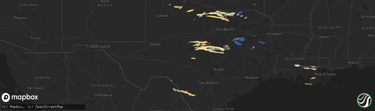
Hail Map in Texas on May 4, 2023
The weather event in Texas on May 4, 2023 includes Hail, Wind, and Tornado maps. 11 states and 224 cities were impacted and suffered possible damage. The total estimated number of properties impacted is 32,156.
Hail
Wind
Tornado
32,156
Estimated number of impacted properties by a 1.00" hail or larger9,790
Estimated number of impacted properties by a 1.75" hail or larger2,115
Estimated number of impacted properties by a 2.50" hail or largerStorm reports in Texas
Texas
| Date | Description |
|---|---|
| 05/04/20236:43 PM CDT | A local report indicates 1.00 inch wind near 7 WNW OWENS |
| 05/04/20236:43 PM CDT | Delayed report: downed tree limbs. Trampoline and charcoal grill blown around. |
| 05/04/20236:16 PM CDT | Strong thunderstorm winds damaged |
| 05/04/20235:47 PM CDT | West texas mesonet site recorded a 68 mph gust. |
| 05/04/20234:55 PM CDT | A local report indicates 63 MPH wind near 3 NW SEYMOUR |
| 05/04/20234:55 PM CDT | Powerlines down. |
| 05/04/20234:34 PM CDT | Video on twitter; time estimated from radar. |
| 05/04/202312:58 AM CDT | Widespread reports of trees and power lines down across nacogdoches co. This includes nacogdoches proper... As well as many locations on the north end of the county. |
| 05/04/202312:55 AM CDT | Numerous trees and power lines were downed throughout the city of nacogdoches. |
| 05/04/202312:48 AM CDT | A tree was downed in the brachfield community. |
| 05/04/202312:25 AM CDT | A tree was downed in reklaw. |
| 05/04/202312:19 AM CDT | Large limbs were downed in rusk. Portions of the city are without power. |
| 05/04/202312:14 AM CDT | Law enforcement reports scattered trees down across the county. No reports of power lines or structural damage. |
| 05/04/202312:05 AM CDT | A power line was downed on ragsdale street in jacksonville. |
| 05/03/202311:45 PM CDT | Tree and roof damage was reported in the frankston area. |
| 05/03/20239:49 PM CDT | Time estimated via radar. |
| 05/03/20239:48 PM CDT | Ping pong size hail resulting in vehicle dents when traveling north on highway 83 near the town of las colonias. Time estimated via radar. |
| 05/03/20239:46 PM CDT | Destroyed vehicle windshields and windows from hail up to baseball size. Time estimated via radar. |
| 05/03/20239:38 PM CDT | Golf ball size hail 6w sanger. |
| 05/03/20239:17 PM CDT | Half dollar size hail 5e slidell. Trees shredded. |
| 05/03/20239:16 PM CDT | Up to tennis ball size hail reported near the flying t o ranch airport in western zavala county. |
| 05/03/20239:13 PM CDT | 67 mph gust measured on sh-289 half-mile south of us 82 west of sherman. |
| 05/03/20239:13 PM CDT | Half dollar size hail covering ground 3e slidell. |
| 05/03/20238:51 PM CDT | Broadcast media relayed report of measured wind near whitesboro. |
| 05/03/20238:28 PM CDT | 60 mph estimated winds on fm1202 north of gainesville. |
| 05/03/20237:38 PM CDT | 2 inch hail 3s democrat. |
| 05/03/20237:28 PM CDT | Quarter size hail between zephyr and democrat. |
| 05/03/20237:05 PM CDT | Powerlines down. Tree damage. Time estimated based on radar. |
All States Impacted by Hail Map on May 4, 2023
Cities Impacted by Hail Map on May 4, 2023
- Canistota, SD
- Montrose, SD
- Humboldt, SD
- Walters, OK
- Frederick, OK
- Loveland, OK
- Davidson, OK
- Salem, SD
- Lockney, TX
- Matador, TX
- Seymour, TX
- Crowell, TX
- Del Rio, TX
- Comstock, TX
- Paducah, TX
- Holliday, TX
- Coleman, TX
- Winters, TX
- Anton, CO
- Childress, TX
- Lagrange, WY
- Burkett, TX
- Rockwood, TX
- Gouldbusk, TX
- Santa Anna, TX
- Brookesmith, TX
- Wichita Falls, TX
- Henrietta, TX
- Cross Plains, TX
- Brownwood, TX
- May, TX
- Windthorst, TX
- Sidney, TX
- Comanche, TX
- Early, TX
- Zephyr, TX
- Bangs, TX
- Bellevue, TX
- Richfield, KS
- Mullin, TX
- Nocona, TX
- Bowie, TX
- Montague, TX
- Hugoton, KS
- Utica, KS
- Dighton, KS
- Blanket, TX
- Priddy, TX
- Goldthwaite, TX
- Hamilton, TX
- Pottsville, TX
- Beeler, KS
- Saint Jo, TX
- Muenster, TX
- Sunset, TX
- Tryon, NE
- Sutherland, NE
- Forestburg, TX
- Gainesville, TX
- Alvord, TX
- Burwell, NE
- Bassett, NE
- Jonesboro, TX
- Quemado, TX
- Decatur, TX
- Whitesboro, TX
- Eagle Pass, TX
- Sanger, TX
- Crystal City, TX
- Krum, TX
- Gatesville, TX
- Valley Mills, TX
- Lometa, TX
- Star, TX
- Sherman, TX
- Denison, TX
- Pottsboro, TX
- Evant, TX
- Bells, TX
- Denton, TX
- Aubrey, TX
- Pilot Point, TX
- Crawford, TX
- Savoy, TX
- Ravenna, TX
- Hendrix, OK
- Oglesby, TX
- McGregor, TX
- Carrizo Springs, TX
- Ivanhoe, TX
- Big Wells, TX
- Telephone, TX
- Compton, CA
- Powell, TX
- Corsicana, TX
- Rice, TX
- Kerens, TX
- Trinidad, TX
- Mabank, TX
- Kemp, TX
- Purdon, TX
- Barry, TX
- Wortham, TX
- Richland, TX
- Dawson, TX
- Mexia, TX
- Streetman, TX
- Long Beach, CA
- Carson, CA
- Weskan, KS
- Centerville, SD
- Bayard, NE
- Gurley, NE
- Lindsay, TX
- Lake Andes, SD
- Rising Star, TX
- Brady, TX
- Hext, TX
- Mason, TX
- Ringgold, TX
- Beresford, SD
- Winona, KS
- Leoti, KS
- Vermillion, SD
- Burbank, SD
- Novice, TX
- Tonasket, WA
- Prairie City, OR
- Stuart, NE
- Healy, KS
- Weinert, TX
- Atkinson, NE
- Laurel, NE
- Newcastle, NE
- Geddes, SD
- Dublin, TX
- Gustine, TX
- Lohn, TX
- Ness City, KS
- Valera, TX
- Bethune, CO
- Burlington, CO
- Talpa, TX
- Rosston, TX
- Thackerville, OK
- Eustace, TX
- Athens, TX
- Malakoff, TX
- Fairfield, TX
- Laneville, TX
- Mount Enterprise, TX
- Long Branch, TX
- Garrison, TX
- Timpson, TX
- Grapeland, TX
- Mason City, NE
- Crofton, NE
- Windom, TX
- Honey Grove, TX
- Bonham, TX
- Dodd City, TX
- Paxton, NE
- Ansley, NE
- Ector, TX
- Era, TX
- Valley View, TX
- West, TX
- Waco, TX
- Aquilla, TX
- China Spring, TX
- Elm Mott, TX
- Cooper, TX
- Pecan Gap, TX
- Woodway, TX
- Sadler, TX
- Ben Franklin, TX
- Roxton, TX
- Ladonia, TX
- Enders, NE
- Wauneta, NE
- Elkhart, TX
- Howe, TX
- Elsie, NE
- Rusk, TX
- Moody, TX
- Copperas Cove, TX
- Lampasas, TX
- Riesel, TX
- Mart, TX
- Frost, TX
- Blooming Grove, TX
- Collinsville, TX
- Alto, TX
- Fort Hood, TX
- Purmela, TX
- Plaquemine, LA
- Addis, LA
- Grosse Tete, LA
- Sunshine, LA
- Saint Gabriel, LA
- Geismar, LA
- Baton Rouge, LA
- Port Allen, LA
- Gonzales, LA
- Prairieville, LA
- Arnaudville, LA
- Church Point, LA
- Opelousas, LA
- Port Barre, LA
- Sunset, LA
- Rattan, OK
- Denham Springs, LA
- Gray, LA
- Thibodaux, LA
- Morgan City, LA
- Gibson, LA
- Donner, LA
- Schriever, LA
- Raceland, LA
- Livingston, LA
- Theriot, LA
- Saint Amant, LA
- Maurepas, LA
- French Settlement, LA


