Hail Map in Holdrege, NE on May 3, 2024
The weather event in Holdrege, NE on May 3, 2024 includes Hail, Tornado, and Wind maps. 14 states and 503 cities were impacted and suffered possible damage. The total estimated number of properties impacted is 4,219.
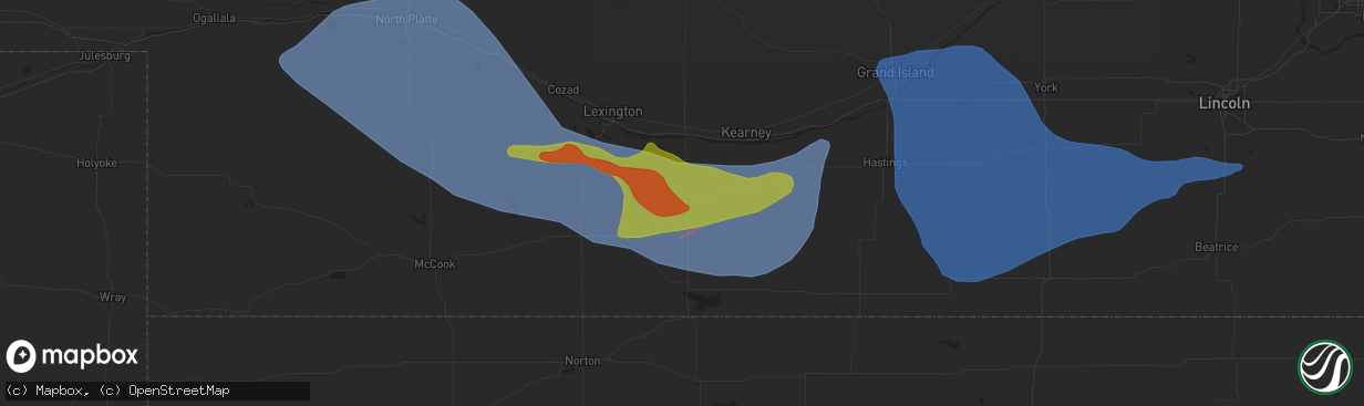
Hail
Tornado
Wind
4,219
Estimated number of impacted properties by a 1.00" hail or larger297
Estimated number of impacted properties by a 1.75" hail or larger0
Estimated number of impacted properties by a 2.50" hail or largerStorm reports in Holdrege, NE
Holdrege, NE
| Date | Description |
|---|---|
| 05/03/20249:10 AM CDT | A local report indicates 2.00 inch wind near Holdrege |
| 05/02/20249:13 PM CDT | Report from mping: quarter |
| 05/02/20249:11 PM CDT | Tornado damage confirmed north and northeast of holdrege. Time estimated from radar. Survey still ongoing. |
| 05/02/20249:10 PM CDT | Report on social media of golf ball size hail in holdrege. |
| 05/02/20249:10 PM CDT | Report on social media of half dollar sized hail in holdrege. |
| 05/02/20249:10 PM CDT | Corrects previous hail report from holdrege. |
| 05/02/20249:08 PM CDT | Pea to quarter sized hail. |
| 05/02/20248:53 PM CDT | Tornado damage confirmed 2w of atlanta. Time estimated from radar. Damage survey is still ongoing. |
All States Impacted by Hail Map on May 3, 2024
All Cities Impacted by Hail Map on May 3, 2024
- Port Arthur, TX
- Anahuac, TX
- Hockley, TX
- Cameron, LA
- Galena Park, TX
- Houston, TX
- Channelview, TX
- Pasadena, TX
- Lovelady, TX
- Crockett, TX
- Cleveland, TX
- Coldspring, TX
- Conroe, TX
- Anderson, TX
- Montgomery, TX
- Richards, TX
- Katy, TX
- Richmond, TX
- Willis, TX
- Winnie, TX
- Crosby, TX
- Beaumont, TX
- New Caney, TX
- Splendora, TX
- Porter, TX
- Broadwater, NE
- Bridgeport, NE
- Huffman, TX
- Magnolia, TX
- Dayton, TX
- Westbrook, TX
- Oshkosh, NE
- Ball Ground, GA
- Normangee, TX
- Colorado City, TX
- Ellsworth, NE
- Columbus, MS
- Baytown, TX
- Highlands, TX
- Franklin, TX
- West Point, MS
- Loraine, TX
- Springer, NM
- Ira, TX
- Snyder, TX
- Fluvanna, TX
- Las Animas, CO
- Maryneal, TX
- Robert Lee, TX
- San Angelo, TX
- Miles, TX
- Justiceburg, TX
- La Porte, TX
- Deer Park, TX
- Blackwell, TX
- Chappell, NE
- Hale Center, TX
- Kress, TX
- Gail, TX
- Shepherd, TX
- Post, TX
- New Market, AL
- Bronte, TX
- Plainview, TX
- Wiley, CO
- Reform, AL
- Hasty, CO
- McClave, CO
- Braselton, GA
- Happy, TX
- Eads, CO
- Adrian, TX
- Hoschton, GA
- Grenville, NM
- Fort Stockton, TX
- Jefferson, GA
- Pendergrass, GA
- Lamar, CO
- Sheridan Lake, CO
- Norton, TX
- Ballinger, TX
- Dryden, TX
- Spur, TX
- Paint Rock, TX
- Eola, TX
- Vega, TX
- Crosbyton, TX
- Mereta, TX
- Dickens, TX
- Ogallala, NE
- Grant, NE
- Lorenzo, TX
- Ralls, TX
- Mcadoo, TX
- Hartley, TX
- Channing, TX
- Madrid, NE
- Paxton, NE
- Elsie, NE
- Clayton, NM
- Afton, TX
- Iraan, TX
- Ozona, TX
- Menard, TX
- Goodfellow Afb, TX
- Syracuse, KS
- Holly, CO
- Wauneta, NE
- Floydada, TX
- Wall, TX
- Eden, TX
- Vancourt, TX
- Wallace, NE
- Roaring Springs, TX
- Tribune, KS
- Woodson, TX
- Hayes Center, NE
- Wray, CO
- Haigler, NE
- Henrietta, TX
- Ovalo, TX
- Walsh, CO
- Dickens, NE
- Matador, TX
- Benkelman, NE
- Hershey, NE
- Manter, KS
- Sheffield, TX
- Graham, TX
- Wellfleet, NE
- Eldorado, TX
- Lockney, TX
- Jacksboro, TX
- Maywood, NE
- North Platte, NE
- Bryson, TX
- Palisade, NE
- Maxwell, NE
- Sutherland, NE
- Leoti, KS
- Genoa, CO
- Hugo, CO
- Kendall, KS
- Wichita Falls, TX
- Arriba, CO
- Flomot, TX
- Turkey, TX
- Moorefield, NE
- Curtis, NE
- Brady, NE
- Quitaque, TX
- Bridgewater, VA
- McCook, NE
- Lakin, KS
- Santa Anna, TX
- Coleman, TX
- Stockville, NE
- Barnhart, TX
- Brownwood, TX
- Christoval, TX
- Flagler, CO
- Kit Carson, CO
- Saint Francis, KS
- Bird City, KS
- McDonald, KS
- Stratton, NE
- Max, NE
- Mertzon, TX
- Fort McKavett, TX
- Cozad, NE
- Eustis, NE
- Farnam, NE
- Gothenburg, NE
- Deerfield, KS
- Sterling City, TX
- Cambridge, NE
- Bartley, NE
- Indianola, NE
- Culbertson, NE
- Trenton, NE
- Colby, KS
- Atwood, KS
- Elwood, NE
- Early, TX
- Zephyr, TX
- Marienthal, KS
- Edson, KS
- Junction, TX
- Blanket, TX
- Geronimo, OK
- Walters, OK
- Big Lake, TX
- Pampa, TX
- Miami, TX
- Seibert, CO
- Vona, CO
- Cheyenne Wells, CO
- Stratton, CO
- Arapahoe, CO
- Liberal, KS
- Hugoton, KS
- Smithfield, NE
- Bertrand, NE
- Garden City, KS
- Lawton, OK
- Holcomb, KS
- Edison, NE
- Arapahoe, NE
- Lebanon, NE
- London, TX
- Hamilton, TX
- Kismet, KS
- Plains, KS
- Satanta, KS
- Meade, KS
- Sublette, KS
- Fowler, KS
- Scott City, KS
- Levant, KS
- Gem, KS
- Ludell, KS
- Herndon, KS
- Oberlin, KS
- Danbury, NE
- Wilsonville, NE
- Oxford, NE
- Holbrook, NE
- Holdrege, NE
- Orleans, NE
- Loomis, NE
- Atlanta, NE
- Overton, NE
- Canadian, TX
- Higgins, TX
- Skellytown, TX
- Summertown, TN
- Hohenwald, TN
- Elgin, OK
- Elm Creek, NE
- Axtell, NE
- Funk, NE
- Minden, NE
- Miller, NE
- Lexington, NE
- Wakeeney, KS
- Collyer, KS
- Hampshire, TN
- Ingalls, KS
- Hendley, NE
- Anadarko, OK
- Fort Cobb, OK
- Carnegie, OK
- Fletcher, OK
- Cyril, OK
- Borger, TX
- Sonora, TX
- Cement, OK
- Apache, OK
- Roosevelt, TX
- Chickasha, OK
- Verden, OK
- Gracemont, OK
- Cimarron, KS
- Alma, NE
- Amber, OK
- Wilcox, NE
- Beaver City, NE
- Republican City, NE
- Hildreth, NE
- Norton, KS
- Minneola, KS
- Montezuma, KS
- Ensign, KS
- Naponee, NE
- Bloomington, NE
- Heartwell, NE
- Gate, OK
- Binger, OK
- Dighton, KS
- Pocasset, OK
- Minco, OK
- Kearney, NE
- Arnett, OK
- Ninnekah, OK
- Franklin, NE
- Upland, NE
- Campbell, NE
- Riverton, NE
- Smith Center, KS
- Kensington, KS
- Rocksprings, TX
- Woodward, OK
- Briscoe, TX
- Buffalo, OK
- Holstein, NE
- Durham, OK
- Inavale, NE
- Bladen, NE
- Kenesaw, NE
- Roseland, NE
- Blue Hill, NE
- Ethelsville, AL
- Mooreland, OK
- Red Cloud, NE
- Sharon, OK
- Ayr, NE
- Hastings, NE
- Glenvil, NE
- Superior, NE
- Newcastle, TX
- Freedom, OK
- Waynoka, OK
- Taloga, OK
- Seiling, OK
- Lawrence, NE
- Nelson, NE
- Guide Rock, NE
- Camargo, OK
- Trumbull, NE
- Doniphan, NE
- Phillips, NE
- Giltner, NE
- Grand Island, NE
- Inland, NE
- Fairfield, NE
- Deweese, NE
- Harvard, NE
- Clay Center, NE
- Edgar, NE
- Davenport, NE
- Oak, NE
- Ruskin, NE
- Aurora, NE
- Chapman, NE
- Ong, NE
- Saronville, NE
- Marquette, NE
- Sutton, NE
- Hampton, NE
- Deshler, NE
- Hebron, NE
- Henderson, NE
- Shickley, NE
- Carleton, NE
- Geneva, NE
- Grafton, NE
- Bruning, NE
- Belvidere, NE
- Strang, NE
- Fairmont, NE
- McCool Junction, NE
- Alexandria, NE
- Ohiowa, NE
- Milligan, NE
- Tobias, NE
- York, NE
- Bradshaw, NE
- Cheyenne, OK
- Chester, OK
- Alva, OK
- Fairview, OK
- Sweetwater, OK
- Central City, NE
- Alda, NE
- Exeter, NE
- Portis, KS
- Hardtner, KS
- Helena, OK
- Hammon, OK
- Medicine Lodge, KS
- Kiowa, KS
- Glen Elder, KS
- Downs, KS
- Gaylord, KS
- Elk City, OK
- Esbon, KS
- Attica, KS
- Aline, OK
- Lake City, KS
- Dacoma, OK
- Butler, OK
- Carmen, OK
- Cherokee, OK
- Western, NE
- Daykin, NE
- Fairbury, NE
- Friend, NE
- Swanton, NE
- Wilber, NE
- Dorchester, NE
- Burlington, OK
- Jet, OK
- Mankato, KS
- Harper, KS
- Manchester, OK
- Waldron, KS
- Hazelton, KS
- Chester, NE
- Beloit, KS
- Crete, NE
- Hallam, NE
- Clatonia, NE
- Wakita, OK
- Anthony, KS
- Bluff City, KS
- Plymouth, NE
- Freeport, KS
- Boise City, OK
- De Witt, NE
- Argonia, KS
- Danville, KS
- Caldwell, KS
- Milton, KS
- Norwich, KS
- Firth, NE
- Martell, NE
- Cortland, NE
- Pickrell, NE
- Conway Springs, KS
- Medford, OK
- Adams, NE
- Haven, KS
- Burrton, KS
- Concordia, KS
- Glasco, KS
- Hickman, NE
- Douglas, NE
- Aurora, KS
- Geuda Springs, KS
- South Haven, KS
- Newkirk, OK
- Clyde, KS
- Miltonvale, KS
- Arkansas City, KS
- Alberta, AL
- Carrollton, AL
- Hillsboro, KS
- Dunbar, NE
- Nebraska City, NE
- Pawhuska, OK
- Shidler, OK
- Randolph, KS
- Talmage, NE
- Chapman, KS
- Junction City, KS
- Waterville, KS
- Hope, KS
- Barnes, KS
- Green, KS
- Galveston, TX
- Greenleaf, KS
- Rosston, OK
- Ashland, KS
- Laverne, OK
- Riley, KS
- Fairfax, OK
- Burbank, OK
- Fort Riley, KS
- Sedan, KS
- Cedar Vale, KS
- Olsburg, KS
- Manhattan, KS
- Ogden, KS
- Frankfort, KS
- Westmoreland, KS
- Saint George, KS
- Wamego, KS
- Mounds, OK
- Beggs, OK
- Okmulgee, OK
- Belvue, KS
- Onaga, KS
- Havensville, KS
- Emmett, KS
- Saint Marys, KS
- Haskell, OK
- Bixby, OK
- Mayetta, KS
- Delia, KS
- Thayer, KS
- Silver Lake, KS
- Rossville, KS
- Soldier, KS
- Circleville, KS
- Parsons, KS
- Redbird, OK
- Porter, OK
- Holton, KS
- Coweta, OK
- Horton, KS
- Galesburg, KS
- Everest, KS
- Muscotah, KS
- Troy, KS
- Savannah, MO
- Amazonia, MO
- Saint Joseph, MO
- Sulphur Springs, AR
- Osborn, MO
- Cameron, MO
- Centerview, MO
- Jasper, MO
- Golden City, MO


