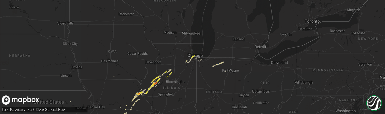
Hail Map on May 2, 2024
The weather event on May 2, 2024 includes Hail, Wind, and Tornado maps. 9 states and 412 cities were impacted and suffered possible damage. The total estimated number of properties impacted is 111,803.
Hail
Wind
Tornado
111,803
Estimated number of impacted properties by a 1.00" hail or larger9,796
Estimated number of impacted properties by a 1.75" hail or larger4,898
Estimated number of impacted properties by a 2.50" hail or largerStates Impacted by Hail Map on May 2, 2024
Storm reports
Kansas
| Date | Description |
|---|---|
| 05/02/20246:55 PM CDT | Delayed report via em. Baseball sized hail. Time estimated via radar. |
| 05/02/20246:35 PM CDT | Delayed report via em. Multiple baseball sized hail stones found. Time estimated via radar. |
Louisiana
| Date | Description |
|---|---|
| 05/02/202411:32 AM CDT | Brief tornado in a field along leblanc road southwest of welsh. No damagae occurred. Report relayed by a spotter. |
| 05/02/202410:09 AM CDT | A weak tornado began near rocky spring rd northeast of many. The tornado continued east... Eventually crossing rocky mount rd and cedar grove rd before ending near the |
Oklahoma
| Date | Description |
|---|---|
| 05/02/20242:35 AM CDT | Report from mping: quarter |
| 05/01/202411:20 PM CDT | Tree down in sequoyah state park. |
| 05/01/202411:00 PM CDT | Strong thunderstorm wind damaged the roof of a home... Uprooted trees... Rolled an rv... And snapped large tree limbs. |
| 05/01/202410:59 PM CDT | Strong thunderstorm wind snapped power poles... And blew down trees on highway 51. |
| 05/01/202410:50 PM CDT | 4 inch red maple tree snapped off near the ground. |
| 05/01/202410:50 PM CDT | A local report indicates 80 MPH wind near 1 W Wagoner |
| 05/01/202410:50 PM CDT | Trees... Powerlines... Road signs down. At us highway 69 and whitehorn cove road and points south. Information relayed via twitter. Time estimated via radar. |
| 05/01/202410:10 PM CDT | Radar estimated time. |
Texas
| Date | Description |
|---|---|
| 05/02/20246:55 PM CDT | Storm chaser confirms tornado on the ground northeast of noodle. |
| 05/02/20246:45 PM CDT | Law enforcement relayed report from storm chaser on tornado on the ground northwest of doole. |
| 05/02/20246:42 PM CDT | Confirmed tornado on ground. |
| 05/02/20246:30 PM CDT | Spotter confirmed tornado on ground. |
| 05/02/20246:30 PM CDT | Concho park marina. Softball size hail. |
| 05/02/20246:29 PM CDT | Report from mping: baseball |
| 05/02/20246:26 PM CDT | Spotter reported 3.5 inch size hail. |
| 05/02/20246:26 PM CDT | Damage to vehicles and holes in metal awnings. |
| 05/02/20246:15 PM CDT | A local report indicates 3.00 inch wind near 1 E Ballinger |
| 05/02/20246:15 PM CDT | A local report indicates 1.00 inch wind near Anson |
| 05/02/20246:15 PM CDT | A local report indicates 2.75 inch wind near 2 WSW Leaday |
| 05/02/20246:02 PM CDT | Spotter reported a tornado on the ground 2 miles southeast of ballinger. |
| 05/02/20245:59 PM CDT | The public reported a tornado on the ground 2.3 miles east of ballinger... Moving east. |
| 05/02/20245:55 PM CDT | Spotter reported a tornado briefly touched down 5 miles northwest of anson. |
| 05/02/20245:43 PM CDT | Report from mping: quarter |
| 05/02/20245:43 PM CDT | On highway 83 tennis ball size. |
| 05/02/20245:32 PM CDT | Report from mping: tennis ball |
| 05/02/20245:31 PM CDT | Report from mping: hen egg+ |
| 05/02/20245:29 PM CDT | Report from mping: hen egg |
| 05/02/20245:28 PM CDT | Report from mping: half dollar |
| 05/02/20245:24 PM CDT | A local report indicates 1.00 inch wind near 7 S Guthrie |
| 05/02/20244:02 PM CDT | A local report indicates 1.00 inch wind near 3 NNE Bronte |
| 05/02/202411:05 AM CDT | Weatherflow station reported a 64 mph wind gust. |
| 05/02/202410:23 AM CDT | Strong thunderstorm wind gusts downed a large tree in a residential neighborhood of kingwood. |
| 05/02/20249:30 AM CDT | Social media pictures show downed trees and wooden fences damaged near imperial promenade drive and hwy 99. |
| 05/02/20249:03 AM CDT | Report of a fallen tree over a school bus as well as fences knocked down at birnham woods drive near elan blvd. |
| 05/02/20248:55 AM CDT | Trees blown down in the area and a commercial building has damage to a garage door. |
| 05/02/20248:53 AM CDT | Photo of a tree and powerlines down on a flooded road. |
| 05/02/20248:53 AM CDT | Numerous trees down in nederland. |
| 05/02/20248:23 AM CDT | Corrects previous tstm wnd dmg report from 1 ese kingwood. Strong thunderstorm wind gusts downed a large tree in a residential neighborhood of kingwood. |
| 05/02/20248:00 AM CDT | Half dollar size hail in kountze. Observed by hardin county emergency management coordinator. |
| 05/02/20245:12 AM CDT | Hardin county em submitted photos of quarter size hail in kountze. |
| 05/02/20243:55 AM CDT | Between 0.75 to 1 inch hail. |
| 05/02/20241:02 AM CDT | Report from mping: quarter |
| 05/02/202412:35 AM CDT | Ktpl awos measured 60 mph. 32041g52kt. |
| 05/01/20249:00 PM CDT | Relayed report. Radar estimated time. |
| 05/01/20248:37 PM CDT | Asos station kabi abilene. |
| 05/01/20248:08 PM CDT | Report from mping: grapefruit- |
| 05/01/20247:45 PM CDT | Report from mping: baseball |
| 05/01/20247:35 PM CDT | Property damage reported southwest of hawley on fm 605. |
| 05/01/20247:25 PM CDT | *** 2 inj *** report of home damaged with at least 2 injuries. |
| 05/01/20247:21 PM CDT | Tornado reported on the ground west of hawley. |
| 05/01/20247:13 PM CDT | Public reported baseball to softball size hail. |
| 05/01/20247:06 PM CDT | 277 just northwest of hawley. |
| 05/01/20247:05 PM CDT | Spotter reports confirmed tornado on the ground 4 to 5 miles west northwest of hawley. |
| 05/01/20247:00 PM CDT | Report from mping: baseball |
Missouri
| Date | Description |
|---|---|
| 05/02/20243:29 PM CDT | 50-60 mph estimated gusts and up to quarter sized hail in town. |
| 05/02/20243:26 PM CDT | Report of golf balls in palmyra by necomm. |
| 05/02/20241:40 PM CDT | Suspected tornado downed trees and caused minor structural damage to homes northwest of the joplin airport around carl junction. |
North Dakota
| Date | Description |
|---|---|
| 05/02/20246:00 PM CDT | Time estimated based on radar. Relayed via broadcast media. |
Arkansas
| Date | Description |
|---|---|
| 05/02/20245:26 AM CDT | Tree down across part of hwy 270 blocking at least one lane. |
| 05/02/20244:57 AM CDT | Picture sent by coop observer of large tree down in front of church. |
Illinois
| Date | Description |
|---|---|
| 05/02/20245:46 PM CDT | Several reports of several large |
| 05/02/20245:46 PM CDT | Several reports of several large limbs down |
| 05/02/20245:45 PM CDT | Photo of a large tree broken off about 3 feet up the trunk. Time of the event was estimated using radar. |
| 05/02/20245:25 PM CDT | Power poles and trees down along us-136. |
| 05/02/20245:18 PM CDT | Reported a large tree limb down. Time of the event estimated using radar. |
| 05/02/20245:12 PM CDT | Relayed by county em. |
| 05/02/20245:10 PM CDT | Power poles down south of smithfield. |
| 05/02/20245:05 PM CDT | Quarter size and larger. |
| 05/02/20245:05 PM CDT | Power poles down on hwy 67... Just se of littleton. |
| 05/02/20245:00 PM CDT | Trees down near intersection of camden rd and daly ln. |
| 05/02/20245:00 PM CDT | Delayed report. Total loss to mobile home. Time estimated by radar. |
| 05/02/20245:00 PM CDT | Structural damage to small pole barn. Time estimated by radar. |
| 05/02/20244:55 PM CDT | A local report indicates 1.75 inch wind near Table Grove |
| 05/02/20244:52 PM CDT | Narrow swath of hail covering the road on 650th street about 2 miles west of table grove. Quarter to ping pong ball sized hail stones. Time estimated by radar. |
| 05/02/20244:50 PM CDT | Large healthy branch downed. |
| 05/02/20244:45 PM CDT | Ranging between half inch and half dollar size... Most around 1 inch. |
| 05/02/20244:44 PM CDT | Between maquon and rapatee. Swop report. |
| 05/02/20244:40 PM CDT | Small plane overturned at dupage airport. Time estimated by radar and nearby asos observations. |
| 05/02/20244:01 PM CDT | Report from mping: quarter |
| 05/02/20243:58 PM CDT | Portion of roofing material peeled off commercial structure near fullerton avenue and ashland avenue in lincoln park community area. Time estimated by radar. |
| 05/02/20243:57 PM CDT | Relayed by ilx and fulton co em. |
| 05/02/20243:56 PM CDT | A few small tree branches downed on streets and cars in the vicinity of 2600 w logan boulevard. Relayed by chicago311. Time estimated by radar. |
| 05/02/20243:56 PM CDT | Corrects previous tstm wnd dmg report from 1 ne logan square - chicago. Photos shared on social media show several large tree branches greater than 8 inches in diameter |
| 05/02/20243:52 PM CDT | Picture of hailstones. Largest estimated 1.25 inches. |
| 05/02/20243:52 PM CDT | Report from mping: 3-inch tree limbs broken; power poles broken. |
| 05/02/20243:46 PM CDT | A local report indicates 1.00 inch wind near 3 S Quincy |
| 05/02/20243:46 PM CDT | Report from mping: quarter |
| 05/02/20243:46 PM CDT | Report from mping: half dollar |
| 05/02/20243:44 PM CDT | Medium sized limbs snapped in a tree. Time estimated from radar. |
| 05/02/20243:44 PM CDT | Quarter to ping pong ball size hail. Picture via social media. |
| 05/02/20243:43 PM CDT | Report from mping: quarter |
| 05/02/20242:59 PM CDT | Private weather station kilchica1007 reported 59 mph gust near logan boulevard and i-90 in the logan square community area. |
| 05/02/20242:45 PM CDT | A local report indicates 1.00 inch wind near Washburn |
| 05/02/20242:05 PM CDT | A local report indicates 1.00 inch wind near 2 SE Peoria Heights |
| 05/02/20242:01 PM CDT | Trained spotter near il-59 and caton farm road reported quarter sized hail. |
| 05/02/20241:55 PM CDT | Trained spotter reported quarter size hail 0.5 miles west of caton farm road and il59 between joliet and plainfield. 0.5 inch hail ongoing at time of report. Time estim |
| 05/01/202410:07 PM CDT | A local report indicates 1.00 inch wind near Bridgeview |
Indiana
| Date | Description |
|---|---|
| 05/02/20243:55 PM CDT | A local report indicates 58 MPH wind near 2 SSW Nappanee |
| 05/02/20243:23 PM CDT | Hail estimated up to quarter size in miller beach neighborhood of gary. |
| 05/02/20243:23 PM CDT | Public estimated 65 mph wind gust. |
Cities Impacted by Hail Map on May 2, 2024
- Akron, CO
- Yuma, CO
- Joes, CO
- Eckley, CO
- Vernon, CO
- Wray, CO
- Cleveland, TX
- Saratoga, TX
- Corydon, IA
- Kountze, TX
- Allerton, IA
- Lenexa, KS
- Shawnee, KS
- Spring, TX
- Tomball, TX
- Magnolia, TX
- Conroe, TX
- Liberty, TX
- Hull, TX
- Silsbee, TX
- Batson, TX
- Porter, TX
- Sour Lake, TX
- Waller, TX
- Hockley, TX
- New Caney, TX
- Pinehurst, TX
- Kingwood, TX
- Huffman, TX
- Humble, TX
- Cypress, TX
- Dayton, TX
- Orange, TX
- Beaumont, TX
- Nederland, TX
- Houston, TX
- Crosby, TX
- Port Neches, TX
- Groves, TX
- Port Arthur, TX
- Westmoreland, KS
- Baytown, TX
- Wallisville, TX
- Anahuac, TX
- Winnie, TX
- Severy, KS
- California, MO
- Jamestown, MO
- Cross Timbers, MO
- Rocheport, MO
- Franklin, MO
- Harrisburg, MO
- Clark, MO
- Warsaw, MO
- Edwards, MO
- Minooka, IL
- Shorewood, IL
- Plainfield, IL
- Joliet, IL
- Carl Junction, MO
- Columbia, MO
- Paris, MO
- Auxvasse, MO
- Oronogo, MO
- Mexico, MO
- Thompson, MO
- Fulton, MO
- Romeoville, IL
- Centertown, MO
- Lowpoint, IL
- Monroe City, MO
- Hunnewell, MO
- Metamora, IL
- Stoutsville, MO
- Peoria Heights, IL
- Peoria, IL
- Washington, IL
- East Peoria, IL
- Chicago, IL
- Washburn, IL
- Varna, IL
- Toluca, IL
- La Rose, IL
- Shelbina, MO
- Philadelphia, MO
- Lockport, IL
- Santa Fe, MO
- Burbank, IL
- Palmyra, MO
- Plymouth, IN
- Culver, IN
- Perry, MO
- Argos, IN
- Taylor, MO
- Center, MO
- Lohman, MO
- Jefferson City, MO
- Maywood, MO
- Quincy, IL
- Gary, IN
- Macomb, IL
- Elmwood, IL
- Bourbon, IN
- Hammond, IN
- Hannibal, MO
- Payson, IL
- Wooldridge, MO
- Hobart, IN
- Lake Station, IN
- Bardolph, IL
- Bushnell, IL
- Brimfield, IL
- Bremen, IN
- Hull, IL
- Portage, IN
- New Lenox, IL
- Nappanee, IN
- Bronte, TX
- Prairie City, IL
- Avon, IL
- Princeville, IL
- Edelstein, IL
- Speer, IL
- Liberty, IL
- Plainville, IL
- Barry, IL
- Etna Green, IN
- Milford, IN
- Ursa, IL
- Fowler, IL
- London Mills, IL
- Sparland, IL
- Clayton, IL
- Ellisville, IL
- New Paris, IN
- Littleton, IL
- Rushville, IL
- Coatsburg, IL
- Camp Point, IL
- Maquon, IL
- Industry, IL
- Vermont, IL
- Adair, IL
- Table Grove, IL
- Timewell, IL
- Syracuse, IN
- Fairview, IL
- Winters, TX
- Millersburg, IN
- Goshen, IN
- Yates City, IL
- Wingate, TX
- Norton, TX
- Ipava, IL
- Ligonier, IN
- Camden, IL
- Huntsville, IL
- Mount Sterling, IL
- Smithfield, IL
- Merkel, TX
- Plymouth, IL
- Topeka, IN
- Cuba, IL
- Lewistown, IL
- Colchester, IL
- Hamlin, TX
- Stamford, TX
- Anson, TX
- Rule, TX
- Canton, IL
- Paducah, TX
- Ballinger, TX
- Astoria, IL
- Dunlap, IL
- Marietta, IL
- Voss, TX
- Haskell, TX
- Farmington, IL
- Paint Rock, TX
- Chillicothe, IL
- Huntington, IN
- Columbia City, IN
- Talpa, TX
- Blackwell, TX
- Henry, IL
- Hinton, OK
- Weinert, TX
- Rochester, TX
- Lacon, IL
- Lookeba, OK
- Gouldbusk, TX
- Millersview, TX
- Magnolia, IL
- O'Brien, TX
- Knox City, TX
- Coleman, TX
- Hennepin, IL
- Munday, TX
- Doole, TX
- Roosevelt, TX
- Sonora, TX
- Seymour, TX
- Hawley, TX
- Lohn, TX
- Goree, TX
- Aspermont, TX
- Junction, TX
- Old Glory, TX
- Rockwood, TX
- Rowena, TX
- Abilene, TX
- Belleview, MO
- Rotan, TX
- Bismarck, MO
- Irondale, MO
- Caledonia, MO
- Rochelle, TX
- Santa Anna, TX
- Eden, TX
- Lueders, TX
- Albany, TX
- Melvin, TX
- Luther, OK
- Wellston, OK
- Crowell, TX
- Vernon, TX
- Clyde, TX
- Richland Springs, TX
- Chandler, OK
- Carney, OK
- Brady, TX
- San Saba, TX
- Chillicothe, TX
- Channahon, IL
- Elwood, IL
- Meeker, OK
- Mokena, IL
- Homer Glen, IL
- Willowbrook, IL
- Willow Springs, IL
- Bolingbrook, IL
- Hico, TX
- Hickory Hills, IL
- Justice, IL
- Bridgeview, IL
- Summit Argo, IL
- La Grange, IL
- Berwyn, IL
- Cicero, IL
- Palos Park, IL
- Orland Park, IL
- Palos Hills, IL
- Lemont, IL
- Iredell, TX
- Quanah, TX
- Oak Lawn, IL
- Jonesboro, TX
- Clifton, TX
- Meridian, TX
- Lyons, IL
- Inola, OK
- Broken Arrow, OK
- Hamilton, TX
- Lometa, TX
- Wagoner, OK
- Cranfills Gap, TX
- Chouteau, OK
- Coweta, OK
- Valera, TX
- Porter, OK
- Holdenville, OK
- Prague, OK
- Wetumka, OK
- Gatesville, TX
- Hulbert, OK
- Lamar, OK
- Dustin, OK
- Valley Mills, TX
- Locust Grove, OK
- Tahlequah, OK
- Fort Gibson, OK
- Mcalester, OK
- China Spring, TX
- Wewoka, OK
- Park Hill, OK
- Hanna, OK
- Fort Hood, TX
- Aquilla, TX
- Waco, TX
- Oglesby, TX
- Cookson, OK
- McGregor, TX
- Woodway, TX
- Moody, TX
- Muskogee, OK
- Temple, TX
- Welling, OK
- Indianola, OK
- Gore, OK
- Belton, TX
- Troy, TX
- Eddy, TX
- Bruceville, TX
- Lorena, TX
- Vian, OK
- Bunch, OK
- Chilton, TX
- Sallisaw, OK
- Hewitt, TX
- Lott, TX
- Marlin, TX
- Riesel, TX
- Rosebud, TX
- Muldrow, OK
- Quinton, OK
- Eufaula, OK
- Roland, OK
- Mart, TX
- Kosse, TX
- Thornton, TX
- Groesbeck, TX
- Macomb, OK
- Reagan, TX
- Wanette, OK
- Bremond, TX
- Konawa, OK
- Catoosa, OK
- Tulsa, OK
- Owasso, OK
- Van Buren, AR
- Fort Smith, AR
- Franklin, TX
- Claremore, OK
- Marquez, TX
- Wilburton, OK
- Jewett, TX
- Donie, TX
- Alma, AR
- Bay City, TX
- Buffalo, TX
- Talihina, OK
- Normangee, TX
- Madisonville, TX
- Charleston, AR
- Oakwood, TX
- Leona, TX
- Ada, OK
- Centerville, TX
- Cecil, AR
- Midway, TX
- Montgomery, TX
- Round Top, TX
- Brashear, TX
- Sulphur Springs, TX
- Wister, OK
- Katy, TX
- Allen, OK
- Roff, OK
- Whiting, IN
- Ledbetter, TX
- Watson, OK
- Smithville, OK
- Brookshire, TX
- Burton, TX
- Carmine, TX
- Crockett, TX
- Lovelady, TX
- Jacksonville, TX
- Richards, TX
- Willis, TX
- Trinity, TX
- Huntsville, TX
- Bellville, TX
- Stratford, OK
- Brenham, TX
- Henderson, TX
- Hempstead, TX
- Mena, AR
- Laneville, TX
- Washington, TX
- Navasota, TX
- Plantersville, TX
- Moscow, TX
- Corrigan, TX
- Mount Ida, AR
- Norman, AR
- Nashville, AR
- La Grange, MO
- Buna, TX
- Splendora, TX
- Elsberry, MO
- Foley, MO
- Troy, MO
- Winfield, MO
- Mendon, IL
- Laddonia, MO
- Murfreesboro, AR
- New Waverly, TX
- Bonnerdale, AR
- Royal, AR
- Pearcy, AR
- Hot Springs National Park, AR
- Texarkana, TX
- La Porte, TX
- Deer Park, TX
- Gurdon, AR
- Highlands, TX
- Malvern, AR
- Leola, AR
- Texarkana, AR
- Okolona, AR
- Fouke, AR