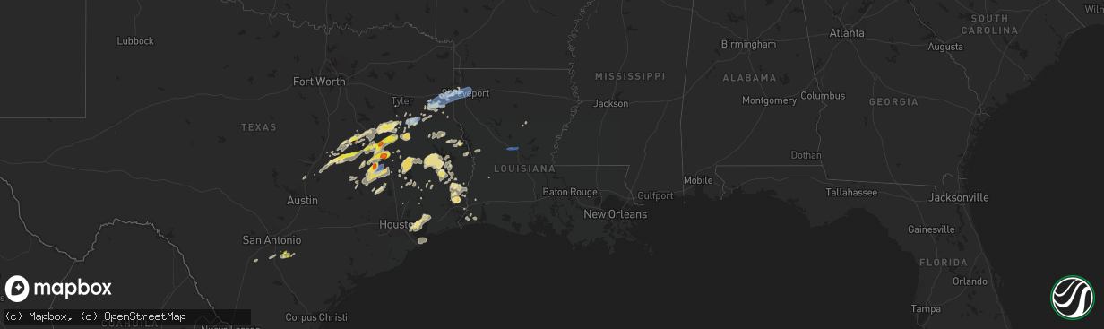
Hail Map in Louisiana on April 28, 2024
The weather event in Louisiana on April 28, 2024 includes Hail, Tornado, and Wind maps. 6 states and 185 cities were impacted and suffered possible damage. The total estimated number of properties impacted is 0.
Hail
Tornado
Wind
0
Estimated number of impacted properties by a 1.00" hail or larger0
Estimated number of impacted properties by a 1.75" hail or larger0
Estimated number of impacted properties by a 2.50" hail or largerStorm reports in Louisiana
Louisiana
| Date | Description |
|---|---|
| 04/28/20245:50 AM CDT | Tree down near interstate 10 at exit 76. Time estimated by radar. |
| 04/28/20245:04 AM CDT | Trees down near st. John elementary school along elliot road. |
| 04/28/20242:09 AM CDT | Emergency manager reports tree down on a home on davis drive. |
| 04/28/20241:55 AM CDT | Photo received of trees down in the tioga area off ates rd. Time estimated by radar. |
| 04/28/20241:55 AM CDT | Video of trees down on rigolette rd. Time estimated by radar. |
| 04/28/20241:52 AM CDT | Trees down west of the tioga area. The results of the survey determined the cause to be straight line wind damage. Wind speed estimated: 80 to 100 mph. |
| 04/28/20241:52 AM CDT | Corrects previous tstm wnd dmg report from 4 wsw ball. Trees down west of the tioga area. The results of the survey determined the cause to be straight line wind damage |
| 04/28/20241:49 AM CDT | Asos station kaex alexandria. |
| 04/28/20241:45 AM CDT | Public reports a lot of damage... Trees down and power outages near st. Marys training school off hwy 1 n. Time estimated by radar. |
| 04/28/20241:37 AM CDT | Photo received of trees down on belgard bend rd in boyce. Time estimated by radar. |
| 04/28/20241:28 AM CDT | Photo received of tree down on cotile rd. Time estimated by radar. |
| 04/28/202412:47 AM CDT | Photo of trees down at hwy 111 and cold springs loop. Time estimated by radar. |
| 04/28/202412:33 AM CDT | Trees down near the high school. Storm survey determined this was straight line wind damage. |
| 04/27/20248:15 PM CDT | Trees and power lines down. |
| 04/27/20247:50 PM CDT | Emergency manager reports several trees down on roadways across town. |
| 04/27/20247:33 PM CDT | An ef0 tornado began along highway 157 and tracked north northeast... Crossing chalybeate springs road and ending shortly thereafter. The tornado produced mainly tree d |
| 04/27/20247:32 PM CDT | An ef1 tornado began near the intersection of still house road and log ferry road and tracked northeast... Paralleling wise road for a few miles before crossing clement |
| 04/27/20247:25 PM CDT | An ef0 tornado touched down along malone road and tracked north northeast for nearly 3 miles across la highway 537 and then still house road before lifting. Along its p |
| 04/27/20247:23 PM CDT | Trees were downed in stonewall. |
| 04/27/20247:14 PM CDT | Reported at kshv...shreveport regional airport asos. |
| 04/27/20247:10 PM CDT | Reported at kdtn...downtown shreveport airport asos. |
| 04/27/20247:10 PM CDT | Trees snapped on tynneside way in south shreveport. |
| 04/27/20247:10 PM CDT | Trees and power lines down on sara lane. |
| 04/27/20247:10 PM CDT | Substantial damage to an apartment building near the 4300 block n market st. |
| 04/27/20247:07 PM CDT | An ef1 tornado touched down on the southwest side of shreveport along cedar creek drive and tracked just over 3 miles through residential areas where it snapped and upr |
| 04/27/20247:05 PM CDT | Multiple trees down along shirley francis road near woolworth road. |
| 04/27/20247:02 PM CDT | At least two trees were downed across woolworth road near walnut hill middle school. |
Cities Impacted by Hail Map on April 28, 2024
- Buckley, MI
- Kingsley, MI
- Fife Lake, MI
- South Boardman, MI
- Pleasanton, TX
- Floresville, TX
- Moore, TX
- Bigfoot, TX
- Poteet, TX
- Poth, TX
- Georgetown, TX
- Chilton, TX
- Falls City, TX
- Riesel, TX
- Marlin, TX
- Groesbeck, TX
- Rogers, TX
- Mart, TX
- Kosse, TX
- Thornton, TX
- Stockdale, TX
- Eddy, TX
- Rosebud, TX
- Lott, TX
- Burlington, TX
- Buckholts, TX
- Holland, TX
- Bartlett, TX
- Mexia, TX
- Bremond, TX
- Reagan, TX
- Teague, TX
- Fairfield, TX
- Buffalo, TX
- Oakwood, TX
- Calvert, TX
- Donie, TX
- Palestine, TX
- Tennessee Colony, TX
- Jewett, TX
- Franklin, TX
- Jacksonville, TX
- Montalba, TX
- Marquez, TX
- Troup, TX
- Frankston, TX
- Centerville, TX
- Hearne, TX
- Elkhart, TX
- Somerville, TX
- Mcalester, OK
- Tulsa, OK
- Normangee, TX
- Rusk, TX
- Canadian, OK
- Broken Arrow, OK
- Grapeland, TX
- College Station, TX
- Leona, TX
- Reklaw, TX
- Anderson, TX
- Laneville, TX
- Owasso, OK
- Madisonville, TX
- Henderson, TX
- Iola, TX
- Bryan, TX
- Cushing, TX
- Mount Enterprise, TX
- Tatum, TX
- Crockett, TX
- Beckville, TX
- North Zulch, TX
- Lovelady, TX
- Bedias, TX
- Alto, TX
- Carthage, TX
- Long Branch, TX
- Marshall, TX
- Shreveport, LA
- Waskom, TX
- Greenwood, LA
- De Berry, TX
- Jenks, OK
- Union City, OK
- Wells, TX
- Mooringsport, LA
- Karnack, TX
- Blanchard, LA
- Midway, TX
- Trinity, TX
- Huntsville, TX
- Heavener, OK
- Tenaha, TX
- Groveton, TX
- Flint, TX
- Billings, MO
- Clever, MO
- Edmond, OK
- Joaquin, TX
- Nacogdoches, TX
- Meridian, OK
- Guthrie, OK
- Luther, OK
- Wellston, OK
- San Augustine, TX
- Center, TX
- Chireno, TX
- Corrigan, TX
- Wortham, TX
- Diboll, TX
- Huntington, TX
- Lufkin, TX
- Navasota, TX
- Chester, TX
- Alpena, AR
- Green Forest, AR
- Zavalla, TX
- Mcloud, OK
- Oakhurst, TX
- Shawnee, OK
- Plantersville, TX
- Colmesneil, TX
- Jasper, TX
- Montgomery, TX
- Woodville, TX
- Richards, TX
- Milam, TX
- Hemphill, TX
- Bronson, TX
- Brookeland, TX
- Broaddus, TX
- Coldspring, TX
- Pointblank, TX
- Hillister, TX
- Pennington, TX
- Collinsville, OK
- Livingston, TX
- Shepherd, TX
- Goodrich, TX
- Florien, LA
- Anacoco, LA
- Hornbeck, LA
- Kirbyville, TX
- Spurger, TX
- Fred, TX
- Silsbee, TX
- Buna, TX
- Cleveland, TX
- Georgetown, LA
- Alexandria, LA
- Pineville, LA
- Boyce, LA
- Olla, LA
- Willis, TX
- New Waverly, TX
- Tullos, LA
- Call, TX
- Bon Wier, TX
- New Caney, TX
- La Porte, TX
- Pasadena, TX
- Baytown, TX
- Dayton, TX
- Deridder, LA
- Vidor, TX
- Wallisville, TX
- Deweyville, TX
- Liberty, TX
- Anahuac, TX
- Orange, TX
- Sulphur, LA
- Vinton, LA
- Hankamer, TX
- Seabrook, TX
- Houston, TX
- Devers, TX
- Bethany, LA
- Keithville, LA
- Bossier City, LA
- Barksdale Afb, LA
- Haughton, LA
- Texas City, TX
- Port Bolivar, TX
- Cameron, LA


