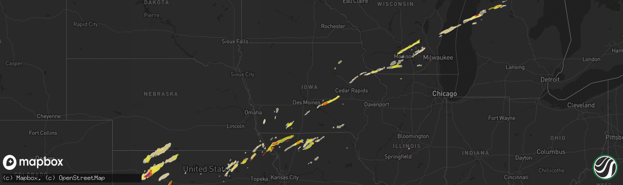
Hail Map in Iowa on April 27, 2024
The weather event in Iowa on April 27, 2024 includes Hail, Wind, and Tornado maps. 11 states and 783 cities were impacted and suffered possible damage. The total estimated number of properties impacted is 4,016.
Hail
Wind
Tornado
4,016
Estimated number of impacted properties by a 1.00" hail or larger478
Estimated number of impacted properties by a 1.75" hail or larger0
Estimated number of impacted properties by a 2.50" hail or largerStorm reports in Iowa
Iowa
| Date | Description |
|---|---|
| 04/27/20246:26 PM CDT | Reports of trees and branches down. Tim |
| 04/27/20246:26 PM CDT | Reports of large trees down and power outages in town. Time estimated via radar. |
| 04/27/20246:26 PM CDT | Reports of trees and branches down. Time estimated via radar. |
| 04/27/20246:15 PM CDT | Via mping report. |
| 04/27/20246:08 PM CDT | Power pole and lines down on hwy 5 1.5 miles north of town. |
| 04/27/20245:22 PM CDT | Dime... Nickel... And quarter ground covered. |
| 04/27/20244:53 PM CDT | Report relayed by media. Time estimated using radar. |
| 04/27/20244:00 PM CDT | Delayed report. Exact location not provided... Only town was given. |
| 04/27/20243:57 PM CDT | Quarter sized hail near sully. |
| 04/26/20248:07 PM CDT | Delayed report. Time estimated from radar. |
| 04/26/20248:03 PM CDT | Large tree downed on a vehicle. Relayed by dispatch. |
| 04/26/20247:40 PM CDT | Also had some small tree branches down. Time estimated from radar. |
| 04/26/20247:10 PM CDT | Delayed social media report of a 70 mph wind gust measured in keota. Time estimated from radar. |
| 04/26/20247:00 PM CDT | Several tree branches of various size down in north english. Time estimated from radar. |
All States Impacted by Hail Map on April 27, 2024
Cities Impacted by Hail Map on April 27, 2024
- Bono, AR
- Shamrock, TX
- Wellington, TX
- Lakeview, TX
- Cheyenne, OK
- Sayre, OK
- Sweetwater, OK
- Wheeler, TX
- Mclean, TX
- Quail, TX
- Reydon, OK
- Hammon, OK
- Leedey, OK
- Okeene, OK
- Longdale, OK
- Briscoe, TX
- Isabella, OK
- Fairview, OK
- Ringwood, OK
- Ames, OK
- Taloga, OK
- Camargo, OK
- Meno, OK
- Paducah, TX
- Vici, OK
- Durham, OK
- Goltry, OK
- Carrier, OK
- Lahoma, OK
- Enid, OK
- Nash, OK
- Kremlin, OK
- Pond Creek, OK
- Seiling, OK
- Chester, OK
- Mutual, OK
- Mooreland, OK
- Medford, OK
- Helena, OK
- Jet, OK
- Waynoka, OK
- Braman, OK
- Cleo Springs, OK
- Aline, OK
- Quanah, TX
- Wellington, KS
- Wakefield, KS
- Abilene, KS
- Crowell, TX
- Canton, OK
- Jayton, TX
- South Haven, KS
- Geuda Springs, KS
- Oxford, KS
- Erick, OK
- Oakwood, OK
- Longford, KS
- Belle Plaine, KS
- Carmen, OK
- Aspermont, TX
- Junction City, KS
- Cherokee, OK
- Mulvane, KS
- Clay Center, KS
- Amorita, OK
- Grandfield, OK
- Winfield, KS
- Udall, KS
- Riley, KS
- Rose Hill, KS
- Douglass, KS
- Eldorado, OK
- Butler, OK
- Rock, KS
- Randolph, KS
- Leonardville, KS
- Green, KS
- Onaga, KS
- Dawson, NE
- Sabetha, KS
- Bern, KS
- Olsburg, KS
- Old Glory, TX
- Dacoma, OK
- Atlanta, KS
- Leon, KS
- Duke, OK
- Blue Rapids, KS
- Greenleaf, KS
- Elk City, OK
- Augusta, KS
- Altus, OK
- Blair, OK
- El Dorado, KS
- Rosalia, KS
- Eureka, KS
- Fairmont, OK
- Westmoreland, KS
- Hiawatha, KS
- Garber, OK
- Douglas, OK
- Barnes, KS
- Salem, NE
- Verdon, NE
- Seymour, TX
- Palmer, KS
- Hunter, OK
- Frankfort, KS
- White Cloud, KS
- Fairfax, MO
- Vermillion, KS
- Barnard, KS
- Mangum, OK
- Olustee, OK
- Lamont, OK
- Covington, OK
- Nardin, OK
- Axtell, KS
- Billings, OK
- Tonkawa, OK
- Lone Wolf, OK
- Skidmore, MO
- Caldwell, KS
- O'Brien, TX
- Craig, MO
- Centralia, KS
- Waterville, KS
- Falls City, NE
- Deer Creek, OK
- Knox City, TX
- Guthrie, OK
- Blackwell, OK
- Ponca City, OK
- Hobart, OK
- Corning, KS
- Goff, KS
- Brownell, KS
- La Crosse, KS
- Burlington Junction, MO
- Clearfield, IA
- Benton, IA
- Blockton, IA
- Diagonal, IA
- Mound City, MO
- Forest City, MO
- Bison, KS
- Wakita, OK
- Newkirk, OK
- Arkansas City, KS
- Vernon, TX
- Hays, KS
- Rock Port, MO
- Rulo, NE
- Maitland, MO
- Oneida, KS
- Seneca, KS
- Bazine, KS
- McCracken, KS
- Shannon City, IA
- Schoenchen, KS
- Liebenthal, KS
- Ransom, KS
- Ellis, KS
- Graham, MO
- Coyle, OK
- Perry, OK
- Two Buttes, CO
- Sentinel, OK
- Rocky, OK
- Cordell, OK
- Barnard, MO
- Maryville, MO
- Fairview, KS
- Stillwater, OK
- Walsh, CO
- Lenox, IA
- Knoxville, IA
- Victoria, KS
- Peck, KS
- Munday, TX
- Mountain View, OK
- Dexter, KS
- Conception Junction, MO
- Electra, TX
- Pleasantville, IA
- Otley, IA
- Imogene, IA
- Ridott, IL
- Freeport, IL
- Dakota, IL
- Morrison, OK
- Maple City, KS
- Morrill, KS
- Baileyville, KS
- Oregon, MO
- Carnegie, OK
- Ravenwood, MO
- Hydro, OK
- Cambridge, KS
- Pella, IA
- Randolph, IA
- Emerson, IA
- Malvern, IA
- Hastings, IA
- Sully, IA
- Marland, OK
- New Virginia, IA
- Gorham, KS
- Rock City, IL
- Afton, IA
- Natoma, KS
- Mayfield, KS
- Bolckow, MO
- Colony, OK
- Corn, OK
- Monroe, IA
- Reasnor, IA
- Indianola, IA
- Lookeba, OK
- Hinton, OK
- Harrold, TX
- Paradise, KS
- Weatherford, OK
- Milo, IA
- Ackworth, IA
- Oklaunion, TX
- Villisca, IA
- Elliott, IA
- Clyde, MO
- Goree, TX
- Davidson, OK
- Lynnville, IA
- Searsboro, IA
- Grinnell, IA
- Cedar Vale, KS
- Stanberry, MO
- Gentry, MO
- Sheridan, MO
- Conception, MO
- Worth, MO
- Parnell, MO
- Lewis, IA
- Waukomis, OK
- Cumberland, IA
- Bison, OK
- Atlantic, IA
- Waldo, KS
- Geary, OK
- Montezuma, IA
- Grant City, MO
- Denver, MO
- Hatfield, MO
- Martinsville, MO
- Calumet, OK
- Grenola, KS
- Hollister, OK
- Loveland, OK
- Frederick, OK
- Shidler, OK
- Wiota, IA
- King City, MO
- Union Star, MO
- Moline, KS
- Howard, KS
- Okarche, OK
- McFall, MO
- Epworth, IA
- Farley, IA
- Dyersville, IA
- Albany, MO
- Center Point, IA
- Walker, IA
- Newton, IA
- Malcom, IA
- Durango, IA
- Dubuque, IA
- Sherrill, IA
- Kingfisher, OK
- Kaw City, OK
- Mount Ayr, IA
- Gilman City, MO
- Trenton, MO
- Coggon, IA
- Ridgeway, MO
- Eagleville, MO
- Pattonsburg, MO
- Princeton, MO
- Bethany, MO
- Spickard, MO
- Elk Falls, KS
- Cuba City, WI
- Hazel Green, WI
- Potosi, WI
- Kieler, WI
- Platteville, WI
- Rochester, TX
- Rule, TX
- Ryan, IA
- New Hampton, MO
- Jameson, MO
- Cambridge, WI
- Deerfield, WI
- Hennessey, OK
- Watonga, OK
- Dover, OK
- Deep River, IA
- Brooklyn, IA
- Guernsey, IA
- Severy, KS
- Indiahoma, OK
- Newtown, MO
- Victor, IA
- Ladora, IA
- Delhi, IA
- Fall River, KS
- Longton, KS
- Manchester, IA
- Johnson Creek, WI
- Lake Mills, WI
- Watertown, WI
- Waterloo, WI
- Fredonia, KS
- Toronto, KS
- Virgil, KS
- Yates Center, KS
- Marshall, OK
- Neosho, WI
- Holy Cross, IA
- Belmont, WI
- Darlington, WI
- Shullsburg, WI
- Marengo, IA
- Lucien, OK
- Sedan, KS
- Coffey, MO
- Lucerne, MO
- Mulhall, OK
- Orlando, OK
- Buffalo, KS
- Lebanon, WI
- Jamesport, MO
- Rubicon, WI
- Iowa Park, TX
- Harris, MO
- Benedict, KS
- Hamlin, TX
- Argyle, WI
- Worthington, IA
- Earlville, IA
- Roby, TX
- Pollock, MO
- Pawhuska, OK
- Galt, MO
- Hustisford, WI
- Milan, MO
- Red Rock, OK
- Sweetwater, TX
- Hermleigh, TX
- Blanchardville, WI
- Rotan, TX
- Peru, KS
- Laredo, MO
- Hale, MO
- Tina, MO
- Chanute, KS
- Humboldt, KS
- Burkburnett, TX
- Chautauqua, KS
- Unionville, MO
- Holliday, TX
- Madison, WI
- Monticello, WI
- La Harpe, KS
- Monroe, WI
- Sheboygan Falls, WI
- Sheboygan, WI
- Janesville, IA
- Cedar Falls, IA
- Denver, IA
- New Vienna, IA
- Iola, KS
- Devol, OK
- Havana, KS
- Elk City, KS
- Randlett, OK
- New Glarus, WI
- Walters, OK
- Black Earth, WI
- Cross Plains, WI
- Dane, WI
- Waunakee, WI
- Middleton, WI
- Lodi, WI
- Green City, MO
- Bucyrus, KS
- Altoona, KS
- Waverly, IA
- Tripoli, IA
- Sumner, IA
- Readlyn, IA
- Crawford, OK
- Sumner, MO
- Owensville, MO
- Cuba, MO
- Moran, KS
- Independence, KS
- Kohler, WI
- Rogers City, MI
- North English, IA
- Elkhart, KS
- Deforest, WI
- Neodesha, KS
- Waucoma, IA
- Hawkeye, IA
- Fredericksburg, IA
- Laclede, MO
- Bronson, KS
- Kincaid, KS
- Marshall, WI
- Meadville, MO
- Bogard, MO
- Johnson, KS
- Grinnell, KS
- Selden, KS
- Oberlin, KS
- Erie, KS
- Arlington, WI
- Morrisonville, WI
- Bloomfield, IA
- Albany, WI
- Rio, WI
- Snyder, TX
- Temple, OK
- Wichita Falls, TX
- Brookfield, MO
- Savonburg, KS
- Niotaze, KS
- Poynette, WI
- Columbus, WI
- Fall River, WI
- Hoxie, KS
- Grainfield, KS
- Thompsonville, MI
- Copemish, MI
- Kingsley, MI
- Fife Lake, MI
- Oakley, KS
- Stark, KS
- Thayer, KS
- Milton, IA
- Douds, IA
- Comanche, OK
- Elsmore, KS
- Floris, IA
- Duncan, OK
- Geronimo, OK
- Cherryvale, KS
- Randolph, WI
- Beaver Dam, WI
- Dresden, KS
- Weinert, TX
- Hollandale, WI
- Mount Horeb, WI
- South Boardman, MI
- Juneau, WI
- Iron Ridge, WI
- Uniontown, KS
- Sheppard Afb, TX
- Reeseville, WI
- Burnett, WI
- Belleville, WI
- Marlow, OK
- Waupun, WI
- Ulysses, KS
- Norcatur, KS
- Redfield, KS
- Manistee, MI
- Onekama, MI
- Verona, WI
- Morland, KS
- Brooklyn, WI
- Sharon, OK
- Bear Lake, MI
- Roscoe, TX
- Maryneal, TX
- Oregon, WI
- Penokee, KS
- Hill City, KS
- Galesburg, KS
- Waurika, OK
- Rush Springs, OK
- Norton, KS
- Brethren, MI
- Kaleva, MI
- Bradley, OK
- Lawton, OK
- Mineral Point, WI
- Loraine, TX
- Haskell, TX
- Coahoma, TX
- Westbrook, TX
- Big Spring, TX
- Saint Paul, KS
- Ninnekah, OK
- Lindsay, OK
- Kingston, OK
- Gordonville, TX
- Alex, OK
- Blanchard, OK
- Fort Scott, KS
- Madill, OK
- Wilsonville, NE
- Hendley, NE
- Hepler, KS
- Mannsville, OK
- Tishomingo, OK
- Wilson, OK
- Lenora, KS
- Ringling, OK
- Beaver City, NE
- Collyer, KS
- Wakeeney, KS
- Medicine Lodge, KS
- Colorado City, TX
- Walnut, KS
- Kalkaska, MI
- Healdton, OK
- Saint Jo, TX
- Muenster, TX
- Purcell, OK
- Washington, OK
- Deerfield, MO
- Buckley, MI
- Ardmore, OK
- Springer, OK
- Mill Creek, OK
- Ludington, MI
- Free Soil, MI
- Mancelona, MI
- Richards, MO
- Prairie View, KS
- Logan, KS
- Midland, TX
- Oxford, NE
- Stamford, NE
- Grayling, MI
- Elmore City, OK
- Pauls Valley, OK
- Burden, KS
- Hennepin, OK
- McCamey, TX
- Mechanicsburg, IL
- Buffalo, IL
- Norman, OK
- Waverly, NE
- Ceresco, NE
- Palco, KS
- Ogallah, KS
- Phillipsburg, KS
- Garden City, TX
- Midkiff, TX
- Ozona, TX
- Ithaca, NE
- Wahoo, NE
- Glade, KS
- Greenwood, NE
- Ashland, NE
- Paoli, OK
- Graham, OK
- Noble, OK
- Ratliff City, OK
- Iraan, TX
- Bessie, OK
- Apache, OK
- Fletcher, OK
- Foss, OK
- Elgin, OK
- Oklahoma City, OK
- Maysville, OK
- Stonewall, OK
- Roff, OK
- Waldron, KS
- Piedmont, KS
- Plainville, KS
- Lexington, OK
- Throckmorton, TX
- Walker, MO
- El Dorado Springs, MO
- Harwood, MO
- Choctaw, OK
- Farlington, KS
- Harrah, OK
- Davis, OK
- Garland, KS
- Whitewater, WI
- Chestnut, IL
- Schell City, MO
- Fort Stockton, TX
- Rankin, TX
- Arcadia, KS
- Bronaugh, MO
- Wynnewood, OK
- Manchester, OK
- Anthony, KS
- Almena, KS
- Newcastle, OK
- Dougherty, OK
- Sulphur, OK
- Burneyville, OK
- Overbrook, OK
- Ada, OK
- Nevada, MO
- Moundville, MO
- Lone Grove, OK
- Elkhorn, WI
- Allen, OK
- Latham, KS
- Orleans, NE
- Chandler, OK
- Milan, KS
- Holdenville, OK
- Sasakwa, OK
- Waukesha, WI
- Meeker, OK
- Sparks, OK
- Sedalia, MO
- Big Lake, TX
- Stamford, TX
- Lewistown, MO
- La Belle, MO
- Davenport, OK
- Stroud, OK
- Hastings, OK
- Anson, TX
- Sylvester, TX
- McCaulley, TX
- Olney, TX
- Newcastle, TX
- Norwich, KS
- Milton, KS
- Milo, MO
- Byers, TX
- Avoca, TX
- Sterling City, TX
- Gainesville, TX
- Wewoka, OK
- Trent, TX
- Wetumka, OK
- Okemah, OK
- Marietta, OK
- Cole Camp, MO
- Mora, MO
- Merkel, TX
- Robert Lee, TX
- Petrolia, TX
- Windsor, MO
- Lincoln, MO
- Cushing, OK
- Depew, OK
- Bristow, OK
- Paden, OK
- Prague, OK
- Cleveland, OK
- Jennings, OK
- Yale, OK
- Drumright, OK
- Mannford, OK
- Kellyville, OK
- Terlton, OK
- Hominy, OK
- Osage, OK
- Sapulpa, OK
- Sand Springs, OK
- Prue, OK
- Skiatook, OK
- Tulsa, OK
- Loco, OK
- Blackwell, TX
- Warsaw, MO
- Lueders, TX
- Barnhart, TX
- Hawley, TX
- Castle, OK
- Windthorst, TX
- Henrietta, TX
- Abilene, TX
- Osceola, MO
- Tye, TX
- Fitzhugh, OK
- Bellevue, TX
- Bronte, TX
- Tuscola, TX
- Wingate, TX
- Fittstown, OK
- Norton, TX
- Winters, TX
- Henryetta, OK
- Okmulgee, OK
- Morris, OK
- Albany, TX
- Eldorado, TX
- Woodson, TX
- Beggs, OK
- Calvin, OK
- Ovalo, TX
- Buffalo Gap, TX
- Weleetka, OK
- Dyess Afb, TX
- Haskell, OK
- Boynton, OK
- Mounds, OK
- Nocona, TX
- Clyde, TX
- Lawn, TX
- San Angelo, TX
- Porter, OK
- Coweta, OK
- Mcalester, OK
- Lamar, OK
- Moran, TX
- Graham, TX
- Breckenridge, TX
- Bixby, OK
- Atwood, OK
- Hanna, OK
- Dustin, OK
- Bowie, TX
- Baird, TX
- Jacksboro, TX
- Ballinger, TX
- Eufaula, OK
- Rowena, TX
- Cisco, TX
- Miles, TX
- Comstock, TX
- Stuart, OK
- Cross Plains, TX
- Ranger, TX
- Paint Rock, TX
- Peggs, OK
- Locust Grove, OK
- Eastland, TX
- Rose, OK
- Alvord, TX
- Sonora, TX
- Burlington, OK
- Burbank, OK
- Voss, TX
- Decatur, TX
- Millersview, TX
- Doole, TX
- Brownwood, TX
- Santa Anna, TX
- Coleman, TX
- Gouldbusk, TX
- Guilford, MO
- Junction, TX
- Roosevelt, TX
- Valera, TX
- Mount Hope, KS
- Rocksprings, TX
- Del Rio, TX
- Burrton, KS
- Haven, KS
- Blanket, TX
- Early, TX
- Halstead, KS
- Comanche, TX
- Sedgwick, KS
- Zephyr, TX
- Mullin, TX
- Gustine, TX
- Dublin, TX
- Roland, OK
- Muldrow, OK
- Van Buren, AR
- San Saba, TX
- Fort Smith, AR
- Brackettville, TX
- Arkoma, OK
- Pickering, MO
- Keosauqua, IA
- Birmingham, IA


