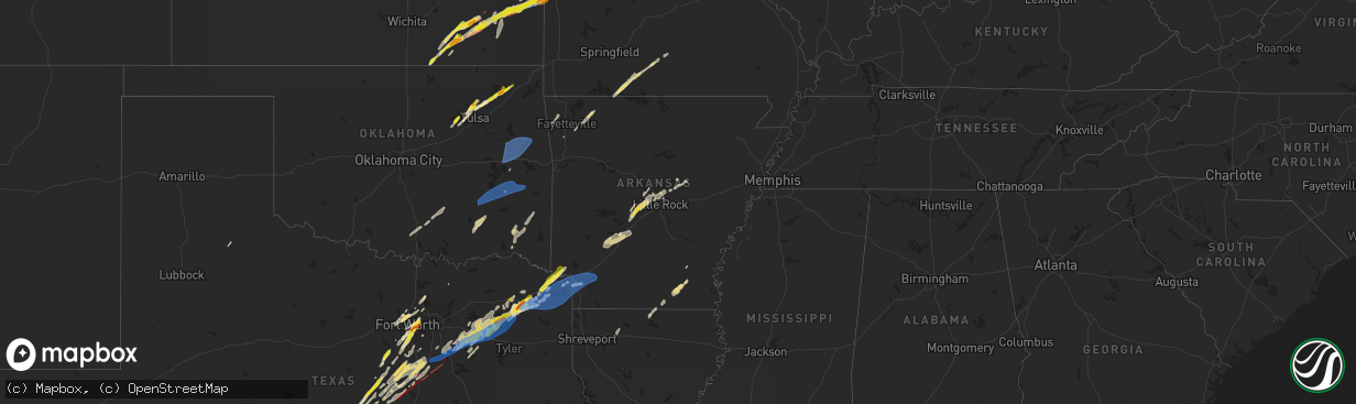
Hail Map in Arkansas on April 26, 2024
The weather event in Arkansas on April 26, 2024 includes Wind, Tornado, and Hail maps. 10 states and 690 cities were impacted and suffered possible damage. The total estimated number of properties impacted is 468.
Wind
Tornado
Hail
468
Estimated number of impacted properties by a 1.00" hail or larger0
Estimated number of impacted properties by a 1.75" hail or larger0
Estimated number of impacted properties by a 2.50" hail or largerStorm reports in Arkansas
Arkansas
| Date | Description |
|---|---|
| 04/26/20246:49 PM CDT | Large tree blown on top of a car causing considerable damage to the vehicle. |
| 04/26/20245:50 PM CDT | Trees and power lines down. |
| 04/26/20245:30 PM CDT | A few trees were blown down in this area. |
| 04/25/20248:52 PM CDT | Numerous trees and powerlines down in weldon. Power is also out. |
| 04/25/20248:38 PM CDT | Multiple large tree branches were blown across highway 64. |
| 04/25/20248:10 PM CDT | Numerous large trees down in searcy... Powerlines also reported down along with fence damage. |
| 04/25/20247:55 PM CDT | Trees down on houses... Powerlines blown over and billboards damaged in town. |
| 04/25/20247:48 PM CDT | Hardwood fence blown over. |
| 04/25/20247:45 PM CDT | Trees reported down in the magness creek area of cabot. Numerous power outages reported as well. |
| 04/25/20247:30 PM CDT | Trees reported blown down in vilonia. |
| 04/25/20247:28 PM CDT | Large tree blown over and resting on a powerline. Numerous people without power. |
| 04/25/20247:25 PM CDT | Large tree limbs down in gibson. Winds estimated to be 60 mph. |
| 04/25/20247:25 PM CDT | A tree was blown over at this location. |
| 04/25/20247:18 PM CDT | 1-inch tree limbs broken; shingles blown off. |
| 04/25/20247:00 PM CDT | Large tree and numerous powerlines are down on highway 35 south. A tree was also on fire. |
All States Impacted by Hail Map on April 26, 2024
Cities Impacted by Hail Map on April 26, 2024
- Newalla, OK
- Mcloud, OK
- Oktaha, OK
- Muskogee, OK
- Warner, OK
- Checotah, OK
- Porum, OK
- Fort Gibson, OK
- Braggs, OK
- Cherryvale, KS
- Neodesha, KS
- Thayer, KS
- Webbers Falls, OK
- Tahlequah, OK
- Gore, OK
- Broken Bow, NE
- Chanute, KS
- Altoona, KS
- Oconto, NE
- Vian, OK
- Park Hill, OK
- Cookson, OK
- Welling, OK
- Ansley, NE
- Lone Grove, OK
- Ardmore, OK
- Springer, OK
- Bunch, OK
- Comstock, NE
- Blanco, OK
- Pittsburg, OK
- Hartshorne, OK
- Mcalester, OK
- Kiowa, OK
- Savanna, OK
- Wilburton, OK
- Haileyville, OK
- Krebs, OK
- Quinton, OK
- Red Oak, OK
- Kinta, OK
- Mccurtain, OK
- Ord, NE
- Sulphur, OK
- Mill Creek, OK
- Elyria, NE
- Roff, OK
- Fitzhugh, OK
- Burwell, NE
- Stonewall, OK
- Mason, TX
- Valley Spring, TX
- Llano, TX
- Castell, TX
- Iredell, TX
- Glen Rose, TX
- Rainbow, TX
- Nemo, TX
- Walnut Springs, TX
- Cherokee, TX
- Cleburne, TX
- Granbury, TX
- Verdigre, NE
- Orchard, NE
- Tow, TX
- San Saba, TX
- Lampasas, TX
- Evant, TX
- Gatesville, TX
- Lometa, TX
- Kempner, TX
- Copperas Cove, TX
- Fort Worth, TX
- Aledo, TX
- Naval Air Station Jrb, TX
- Jonesboro, TX
- Purmela, TX
- Hamilton, TX
- Kopperl, TX
- Denton, TX
- Lake Dallas, TX
- Argyle, TX
- Lewisville, TX
- Little Elm, TX
- Meridian, TX
- Morgan, TX
- Hico, TX
- Cranfills Gap, TX
- Valley Mills, TX
- Aubrey, TX
- Elkins, AR
- Winslow, AR
- Ravenna, NE
- Oglesby, TX
- Crawford, TX
- Keene, TX
- Burleson, TX
- Joshua, TX
- Fayetteville, AR
- Crowley, TX
- Mansfield, TX
- Kennedale, TX
- Arlington, TX
- McGregor, TX
- Anthon, IA
- Oto, IA
- Huntsville, AR
- Wesley, AR
- Godley, TX
- Clifton, TX
- Alvarado, TX
- Bend, TX
- Grand Prairie, TX
- Correctionville, IA
- Pierson, IA
- Brayton, IA
- Exira, IA
- Atlantic, IA
- Rockville, NE
- Keller, TX
- Elk Horn, IA
- Harlan, IA
- Haslet, TX
- Euless, TX
- Washta, IA
- Marcus, IA
- Quimby, IA
- Cleghorn, IA
- China Spring, TX
- Waco, TX
- Audubon, IA
- Flower Mound, TX
- Irwin, IA
- Kimballton, IA
- Kirkman, IA
- West, TX
- Grapevine, TX
- Coppell, TX
- North Richland Hills, TX
- Southlake, TX
- Colleyville, TX
- Berryville, AR
- Adair, IA
- Guthrie Center, IA
- Hamlin, IA
- Meriden, IA
- Kearney, NE
- Coon Rapids, IA
- Narka, KS
- Ashton, NE
- Abbott, TX
- Hubbell, NE
- Reynolds, NE
- Axtell, NE
- Minden, NE
- Manning, IA
- Penelope, TX
- Elba, NE
- Farwell, NE
- Paullina, IA
- Sulphur Springs, TX
- Larrabee, IA
- Cherokee, IA
- Hebron, NE
- Fairbury, NE
- Mahaska, KS
- Van Alstyne, TX
- Whitney, TX
- Hillsboro, TX
- Omaha, AR
- Ridgedale, MO
- Hollister, MO
- Aquilla, TX
- Scotia, NE
- Frost, TX
- Cedarcreek, MO
- Kirbyville, MO
- Blum, TX
- Alexandria, NE
- Rio Vista, TX
- Tobias, NE
- Daykin, NE
- Friend, NE
- Jansen, NE
- Plymouth, NE
- Wolbach, NE
- Saint Paul, NE
- Gibbon, NE
- Shelton, NE
- Greeley, NE
- Purdon, TX
- Barry, TX
- Primghar, IA
- Kissee Mills, MO
- Rueter, MO
- Grandview, TX
- Covington, TX
- Pleasanton, NE
- Western, NE
- Swanton, NE
- Sutherland, IA
- Hartley, IA
- Exeter, NE
- Linn, KS
- Mount Vernon, TX
- De Witt, NE
- Beaver Crossing, NE
- Wilber, NE
- Crete, NE
- Bradleyville, MO
- Ava, MO
- Thornfield, MO
- Cordova, NE
- Milford, NE
- Pontotoc, TX
- Maple City, KS
- Arkansas City, KS
- Dexter, KS
- Corsicana, TX
- Denton, NE
- Pleasant Dale, NE
- Cambridge, KS
- Newkirk, OK
- Utica, NE
- Stringtown, OK
- Lane, OK
- Squires, MO
- Bynum, TX
- Atoka, OK
- Spalding, NE
- Lincoln, NE
- Martell, NE
- Cedar Rapids, NE
- Primrose, NE
- North Loup, NE
- Malone, TX
- Norwood, MO
- Drury, MO
- Seward, NE
- Daisy, OK
- Cedar Hill, TX
- Genoa, NE
- Saint Edward, NE
- Staplehurst, NE
- Ulysses, NE
- Cedar Vale, KS
- Grenola, KS
- Howard, KS
- Piedmont, KS
- Raymond, NE
- Malcolm, NE
- Mountain Grove, MO
- Vanzant, MO
- Severy, KS
- Fall River, KS
- Waverly, NE
- Davey, NE
- Ceresco, NE
- Dwight, NE
- Cabool, MO
- Mertens, TX
- Moline, KS
- Elk Falls, KS
- Greenwood, NE
- Ashland, NE
- Wahoo, NE
- Ithaca, NE
- David City, NE
- Mead, NE
- Albion, NE
- Elgin, NE
- Brainard, NE
- Salem, SD
- Yutan, NE
- Fredonia, KS
- Toronto, KS
- Waterloo, NE
- Valley, NE
- Winfred, SD
- Petersburg, NE
- Itasca, TX
- Clearwater, NE
- Oakdale, NE
- Neligh, NE
- Maypearl, TX
- Milford, TX
- Valparaiso, NE
- Longton, KS
- Elkhorn, NE
- Newman Grove, NE
- Ennis, TX
- Scroggins, TX
- Scurry, TX
- Rosser, TX
- Waxahachie, TX
- Bennington, NE
- Arlington, NE
- Kennard, NE
- Blooming Grove, TX
- Italy, TX
- Blair, NE
- Washington, NE
- Colon, NE
- Fremont, NE
- Leesburg, TX
- Winnsboro, TX
- Vermillion, KS
- Palmyra, NE
- Platte Center, NE
- Humphrey, NE
- Mount Pleasant, TX
- Winfield, TX
- Centralia, KS
- Baileyville, KS
- Columbus, NE
- Elmwood, NE
- Murdock, NE
- Weeping Water, NE
- Weston, NE
- Bristow, OK
- Mannford, OK
- Yates Center, KS
- Creston, NE
- Leigh, NE
- Benedict, KS
- Seneca, KS
- Sand Springs, OK
- Cleveland, OK
- Tulsa, OK
- Wills Point, TX
- Kemp, TX
- Steinauer, NE
- Table Rock, NE
- Pawnee City, NE
- Unadilla, NE
- Louisville, NE
- Buffalo, KS
- Pittsburg, TX
- Terrell, TX
- Sapulpa, OK
- Rising City, NE
- Rice, TX
- Chatfield, TX
- Kaufman, TX
- Mabank, TX
- Johnson, NE
- Brock, NE
- Auburn, NE
- Missouri Valley, IA
- Modale, IA
- Maywood, NE
- Holstein, NE
- Hayes Center, NE
- Haxtun, CO
- Fleming, CO
- Edgar, NE
- Eustis, NE
- Geneva, NE
- Ohiowa, NE
- Hastings, NE
- Cortland, NE
- Moorefield, NE
- Milligan, NE
- Sutton, NE
- Sterling, CO
- Stockville, NE
- Funk, NE
- Evans, CO
- Ayr, NE
- Sterling, NE
- Elwood, NE
- Champion, NE
- Kersey, CO
- Curtis, NE
- Adams, NE
- Greeley, CO
- Cook, NE
- Roseland, NE
- Holyoke, CO
- McCook, NE
- Akron, CO
- Bertrand, NE
- Clay Center, NE
- Glenvil, NE
- Clatonia, NE
- Wauneta, NE
- Firth, NE
- Holdrege, NE
- Snyder, CO
- Otis, CO
- Loomis, NE
- Merino, CO
- Shickley, NE
- Palisade, NE
- Enders, NE
- Imperial, NE
- Weldona, CO
- Bern, KS
- Du Bois, NE
- Humboldt, NE
- Dawson, NE
- Sperry, OK
- Skiatook, OK
- Edgewood, TX
- Springfield, NE
- Manley, NE
- Cedar Creek, NE
- Fruitvale, TX
- Elk Creek, NE
- Springdale, AR
- Siloam Springs, AR
- Point, TX
- Yantis, TX
- Emory, TX
- Lincoln, AR
- Herman, NE
- Humboldt, KS
- Nebraska City, NE
- Bellwood, NE
- La Vista, NE
- Papillion, NE
- Omaha, NE
- Mondamin, IA
- Bellevue, NE
- Julian, NE
- Talmage, NE
- Oneida, KS
- Sabetha, KS
- Como, TX
- Canton, TX
- Alba, TX
- Grand Saline, TX
- Plattsmouth, NE
- Union, NE
- Lindsay, NE
- Iola, KS
- La Harpe, KS
- Carter Lake, IA
- Crescent, IA
- Hamburg, IA
- Rock Port, MO
- Sidney, IA
- Council Bluffs, IA
- Palmer, TX
- Pacific Junction, IA
- Glenwood, IA
- Collinsville, OK
- Owasso, OK
- Peru, NE
- Gretna, NE
- Verdon, NE
- Salem, NE
- Stella, NE
- Shubert, NE
- Madison, NE
- Little Sioux, IA
- Pisgah, IA
- Pickton, TX
- Saltillo, TX
- Nemaha, NE
- Elsmore, KS
- Moran, KS
- Falls City, NE
- Tekamah, NE
- Honey Creek, IA
- Ben Wheeler, TX
- Van, TX
- Neola, IA
- McClelland, IA
- Uniontown, KS
- Bronson, KS
- Fort Calhoun, NE
- Silver Creek, NE
- Nash, TX
- Texarkana, TX
- Savonburg, KS
- Oologah, OK
- Claremore, OK
- Morrill, KS
- Brownville, NE
- Logan, IA
- Mineola, TX
- Lindale, TX
- Quitman, TX
- Soldier, IA
- Hiawatha, KS
- Underwood, IA
- Fairfax, MO
- Moorhead, IA
- Chelsea, OK
- Minden, IA
- Hawkins, TX
- Rulo, NE
- Craig, MO
- Shelby, IA
- Mapleton, KS
- Redfield, KS
- Fulton, KS
- White Cloud, KS
- Daingerfield, TX
- Omaha, TX
- Tarkio, MO
- Westboro, MO
- Naples, TX
- Blue Mound, KS
- Fort Scott, KS
- Prescott, KS
- Burlington Junction, MO
- Hughes Springs, TX
- Marietta, TX
- Linden, TX
- Douglassville, TX
- Simms, TX
- Portsmouth, IA
- Hume, MO
- Rich Hill, MO
- Trinidad, TX
- Big Cabin, OK
- Persia, IA
- Blanchard, IA
- Eustace, TX
- Coin, IA
- Northboro, IA
- Elmo, MO
- Clearmont, MO
- Vinita, OK
- Mound City, MO
- Atlanta, TX
- Hooks, TX
- Maud, TX
- New Boston, TX
- Gilmer, TX
- Westphalia, IA
- Earling, IA
- Defiance, IA
- Foster, MO
- Butler, MO
- Skidmore, MO
- Forest City, MO
- Panama, IA
- Okolona, AR
- Clarinda, IA
- College Springs, IA
- Braddyville, IA
- Shambaugh, IA
- Malakoff, TX
- Queen City, TX
- Maitland, MO
- Texarkana, AR
- Fouke, AR
- Treynor, IA
- Manilla, IA
- Nodaway, IA
- New Market, IA
- Oregon, MO
- Arkadelphia, AR
- Villisca, IA
- Bedford, IA
- Amity, AR
- Lenox, IA
- Benton, AR
- Kincaid, KS
- Donaldson, AR
- Friendship, AR
- Bismarck, AR
- Gravity, IA
- Lonsdale, AR
- Hot Springs National Park, AR
- Malvern, AR
- Hot Springs Village, AR
- Corning, IA
- Garland City, AR
- Fulton, AR
- Lewisville, AR
- Hope, AR
- Denison, IA
- Alexander, AR
- Little Rock, AR
- Paron, AR
- Sharpsburg, IA
- Prescott, IA
- Mound City, KS
- Creston, IA
- Cromwell, IA
- Roland, AR
- Littleton, CO
- Sheridan, MO
- Grant City, MO
- Redding, IA
- Blockton, IA
- Afton, IA
- Avoca, IA
- Pleasanton, KS
- Maumelle, AR
- Ramona, OK
- Mayflower, AR
- Massena, IA
- Conway, AR
- Hancock, IA
- Pickering, MO
- Maryville, MO
- Hopkins, MO
- Mount Ayr, IA
- North Little Rock, AR
- Sherwood, AR
- Aspinwall, IA
- Arcadia, IA
- Westside, IA
- Lorimor, IA
- Morrison, CO
- Fontanelle, IA
- Kellerton, IA
- Tingley, IA
- Ellston, IA
- Cabot, AR
- Jacksonville, AR
- Little Rock Air Force Base, AR
- Carroll, IA
- Breda, IA
- Cookville, TX
- Winterset, IA
- Auburn, IA
- Lake City, IA
- Peru, IA
- Ward, AR
- McRae, AR
- Austin, AR
- Beebe, AR
- Clearfield, IA
- Diagonal, IA
- Benton, IA
- Cumming, IA
- Van Meter, IA
- Prole, IA
- Grand River, IA
- Murray, IA
- Searcy, AR
- Garner, AR
- Osceola, IA
- Shannon City, IA
- Des Moines, IA
- Pleasant Hill, IA
- Altoona, IA
- New Virginia, IA
- West Des Moines, IA
- Indianola, IA
- De Kalb, TX
- Ackworth, IA
- Milo, IA
- Gibsland, LA
- Thayer, IA
- Swan, IA
- Athens, LA
- Carlisle, IA
- Ravenwood, MO
- Parnell, MO
- Pleasantville, IA
- Runnells, IA
- Prairie City, IA
- Monroe, IA
- Hartford, IA
- Monticello, AR
- Homer, LA
- Minden, LA
- Ashdown, AR
- Foreman, AR
- Newton, IA
- Farmerville, LA
- Macksburg, IA
- Marion, LA
- Windsor Heights, IA
- Fort Towson, OK
- Clive, IA
- Urbandale, IA
- Huttig, AR
- Ringold, OK
- Rattan, OK
- Rufe, OK
- Valliant, OK
- Broken Bow, OK
- Hermitage, AR
- Hamburg, AR
- Crossett, AR
- Ramona, SD
- Otley, IA
- Fountain Hill, AR
- Bethel, OK
- Smithville, OK
- Honobia, OK
- Matador, TX


