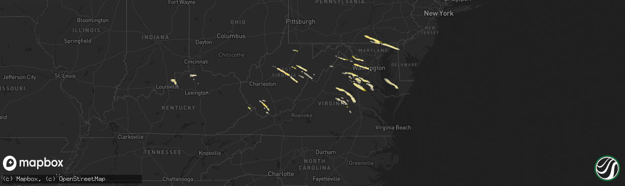
Hail Map in Virginia on April 15, 2024
The weather event in Virginia on April 15, 2024 includes Hail, Wind, and Tornado maps. 15 states and 620 cities were impacted and suffered possible damage. The total estimated number of properties impacted is 67,367.
Hail
Wind
Tornado
67,367
Estimated number of impacted properties by a 1.00" hail or larger383
Estimated number of impacted properties by a 1.75" hail or larger0
Estimated number of impacted properties by a 2.50" hail or largerStorm reports in Virginia
Virginia
| Date | Description |
|---|---|
| 04/15/20246:39 PM CDT | Quarter-sized hail on us-60 in powhatan. |
| 04/15/20246:13 PM CDT | Trees down on centerville rd. |
| 04/15/20246:13 PM CDT | Quarter hail in mountcastle. Time is radar estimated. |
| 04/15/20245:35 PM CDT | Trees down resulting in lane closures. |
| 04/15/20245:35 PM CDT | Trees down blocking lanes. |
| 04/15/20245:30 PM CDT | Pear trees blown down. |
| 04/15/20245:29 PM CDT | Trees down and lane closures. |
| 04/15/20245:28 PM CDT | Trees down along ashland rd near hawks rise lane. Several other roads in the area blocked by trees. |
| 04/15/20245:17 PM CDT | Trees down near highway 33 south of montpelier. Dime to nickel size hail. |
| 04/15/20245:10 PM CDT | High winds and a couple of trees down near sparta. |
| 04/15/20245:00 PM CDT | A few trees down near heathsville. |
| 04/15/20244:54 PM CDT | A local report indicates 1.00 inch wind near 3 SW Cunningham |
| 04/15/20244:44 PM CDT | A local report indicates 1.00 inch wind near Pendleton |
| 04/15/20244:39 PM CDT | Trees on power lines near kinsale. |
| 04/15/20244:21 PM CDT | Report of tree down on smith station rd. |
| 04/15/20244:13 PM CDT | Trees down near monroe hall. |
| 04/15/20243:53 PM CDT | A local report indicates 1.00 inch wind near 4 NW Green Springs |
| 04/15/20243:50 PM CDT | A local report indicates 1.00 inch wind near Gordonsville |
| 04/15/20243:23 PM CDT | A local report indicates 1.25 inch wind near 2 WSW Eheart |
| 04/15/20243:22 PM CDT | A local report indicates 1.00 inch wind near 1 SW Garrisonville |
| 04/15/20242:36 PM CDT | A local report indicates 1.00 inch wind near Warrenton |
| 04/15/20242:32 PM CDT | A local report indicates 1.00 inch wind near 1 WNW Reagan National A |
| 04/15/20242:29 PM CDT | A local report indicates 1.00 inch wind near 2 W Reagan National Air |
| 04/15/20242:29 PM CDT | Delayed report. Public reports hail in catlett... Va. Time estimated from radar. |
| 04/15/20242:21 PM CDT | A trained spotter reported 1 inch hail near the 400 block of w broad st in falls church. |
| 04/15/20242:18 PM CDT | A local report indicates 1.00 inch wind near Vienna |
| 04/15/20242:15 PM CDT | A local report indicates 1.00 inch wind near Westover |
| 04/15/20242:15 PM CDT | Nws employee reported half dollar sized hail. |
| 04/15/20242:15 PM CDT | A local report indicates 1.00 inch wind near Falls Church |
| 04/15/20242:15 PM CDT | A local report indicates 1.50 inch wind near 1 SW Westover |
| 04/15/20242:13 PM CDT | Emergency management reported half dollar size hail near the east falls church metro station. |
| 04/15/20241:42 PM CDT | Nws employee reported quarter sized hail. |
| 04/15/20241:40 PM CDT | A trained spotter reported quarter sized hail in brambleton. |
| 04/15/20241:40 PM CDT | Reported golf ball sized hail in hanson park. |
| 04/15/202412:59 PM CDT | A local report indicates 1.00 inch wind near 3 S Lucketts |
| 04/15/202412:35 PM CDT | Delayed report. Several reports received from public of dime to quarter-sized hail in north side of winchester. Time estimated from radar. |
| 04/14/20247:03 PM CDT | Trees down and lanes blocked. |
| 04/14/20247:01 PM CDT | High winds and a few trees down in the winterpock area. |
All States Impacted by Hail Map on April 15, 2024
Cities Impacted by Hail Map on April 15, 2024
- Fairmont, WV
- Winchester, VA
- High View, WV
- Berryville, VA
- Stephenson, VA
- Purcellville, VA
- Lovettsville, VA
- Waterford, VA
- Leesburg, VA
- Paeonian Springs, VA
- Dickerson, MD
- Wardensville, WV
- Beallsville, MD
- Poolesville, MD
- Boyds, MD
- Woodstock, VA
- Germantown, MD
- Coalton, WV
- Ellamore, WV
- Gaithersburg, MD
- Middleburg, VA
- Buckhannon, WV
- Carolina, WV
- Farmington, WV
- Worthington, WV
- Mabie, WV
- Norton, WV
- Beverly, WV
- Elkins, WV
- Aldie, VA
- Ashburn, VA
- Sterling, VA
- Glady, WV
- Herndon, VA
- Reston, VA
- Vienna, VA
- Oakton, VA
- Chantilly, VA
- Warrenton, VA
- French Creek, WV
- Tallmansville, WV
- Dunn Loring, VA
- Falls Church, VA
- Arlington, VA
- Adrian, WV
- Horner, WV
- Fort Myer, VA
- Midland, VA
- Catlett, VA
- Street, MD
- Pylesville, MD
- Whiteford, MD
- Washington, DC
- Round Hill, VA
- Bluemont, VA
- Amissville, VA
- Marshall, VA
- Gardners, PA
- Biglerville, PA
- Aspers, PA
- Darlington, MD
- Port Deposit, MD
- Conowingo, MD
- East Berlin, PA
- New Oxford, PA
- York Springs, PA
- Gettysburg, PA
- Abbottstown, PA
- Perryville, MD
- Havre De Grace, MD
- Alexandria, VA
- North East, MD
- Charlestown, MD
- Hanover, PA
- Spring Grove, PA
- Fort Washington, MD
- Temple Hills, MD
- Stafford, VA
- Mill Creek, WV
- Valley Bend, WV
- Elkton, MD
- Chesapeake City, MD
- Middletown, DE
- Nokesville, VA
- Nanjemoy, MD
- Quantico, VA
- Triangle, VA
- Jeffersonton, VA
- Remington, VA
- Parkton, MD
- New Freedom, PA
- White Hall, MD
- Freeland, MD
- Grantsville, WV
- Seven Valleys, PA
- Glen Rock, PA
- Washington, VA
- Barboursville, VA
- Ruckersville, VA
- Welcome, MD
- Charlottesville, VA
- Stewartstown, PA
- Shrewsbury, PA
- Newark, DE
- Normantown, WV
- Circleville, WV
- Bartow, WV
- Arnoldsburg, WV
- Bealeton, VA
- Cedarville, WV
- Gassaway, WV
- Exchange, WV
- Gordonsville, VA
- Rosedale, WV
- King George, VA
- Oxon Hill, MD
- Blue Grass, VA
- Franklin, WV
- Naval Anacost Annex, DC
- Taylors Island, MD
- Madison, MD
- Newburg, MD
- Goldvein, VA
- Fredericksburg, VA
- Railroad, PA
- Dahlgren, VA
- Glenville, PA
- Sumerduck, VA
- Richardsville, VA
- Huttonsville, WV
- Sutton, WV
- Flatwoods, WV
- Colonial Beach, VA
- Issue, MD
- Church Creek, MD
- Louisa, VA
- Woolford, MD
- Durbin, WV
- Spotsylvania, VA
- Lignum, VA
- Elkwood, VA
- Diana, WV
- Cowen, WV
- Fawn Grove, PA
- New Park, PA
- Garden City, TX
- Cobb Island, MD
- Montross, VA
- Cambridge, MD
- Crapo, MD
- Mineral, VA
- Big Spring, TX
- Port Royal, VA
- Woodford, VA
- Rappahannock Academy, VA
- Webster Springs, WV
- Colorado City, TX
- Westbrook, TX
- Vienna, MD
- Keswick, VA
- Nanticoke, MD
- Princess Anne, MD
- Tyaskin, MD
- Slatyfork, WV
- Valley Head, WV
- Bergoo, WV
- Bumpass, VA
- Bivalve, MD
- Palmyra, VA
- Scottsville, VA
- Snyder, TX
- Hermleigh, TX
- Coahoma, TX
- Montpelier, VA
- Bremo Bluff, VA
- Glen Allen, VA
- Quantico, MD
- Rockville, VA
- Beaverdam, VA
- Fork Union, VA
- Columbia, VA
- Goochland, VA
- Kents Store, VA
- Whitman, NE
- Aspermont, TX
- Hermosa, SD
- Sundance, WY
- Beulah, WY
- Sandy Hook, VA
- Gum Spring, VA
- Earlysville, VA
- Old Glory, TX
- Valentine, NE
- Kilgore, NE
- Crookston, NE
- Paducah, TX
- Custer, SD
- Charlestown, IN
- Thermopolis, WY
- Edgemont, SD
- Mullen, NE
- Aladdin, WY
- Belle Fourche, SD
- Wanblee, SD
- Kadoka, SD
- Saint Francis, SD
- Hill City, SD
- Cody, NE
- Cartersville, VA
- Goshen, KY
- Westport, KY
- La Grange, KY
- Newcastle, WY
- Hot Springs, SD
- Rapid City, SD
- Seymour, TX
- Crowell, TX
- Piedmont, SD
- Long Valley, SD
- Black Hawk, SD
- Parmelee, SD
- Keystone, SD
- Spearfish, SD
- Norris, SD
- White River, SD
- Sturgis, SD
- Powhatan, VA
- Quanah, TX
- Box Elder, SD
- Ellsworth Afb, SD
- Wall, SD
- Quinn, SD
- Chillicothe, TX
- Eldorado, OK
- Wood Lake, NE
- Wasta, SD
- Buckner, KY
- Tuthill, SD
- Moseley, VA
- Cyclone, WV
- Philip, SD
- Olustee, OK
- Altus, OK
- Glen Fork, WV
- Brenton, WV
- Pineville, WV
- Jesse, WV
- Oceana, WV
- Matheny, WV
- Elmer, OK
- Davin, WV
- Martin, SD
- Mission, SD
- Crestwood, KY
- Belvidere, SD
- Saulsville, WV
- New Richmond, WV
- Herndon, WV
- Williamstown, KY
- Dry Ridge, KY
- Ransom, KY
- Phelps, KY
- Allen, SD
- Jonesville, KY
- New Underwood, SD
- Owenton, KY
- Wood, SD
- Midland, SD
- Shelbyville, KY
- Simpsonville, KY
- Scenic, SD
- Northfork, WV
- Welch, WV
- Timber Lake, SD
- Fairburn, SD
- Anawalt, WV
- Murdo, SD
- Corinth, KY
- Kimper, KY
- Pinsonfork, KY
- Owanka, SD
- Buffalo Gap, SD
- Hurley, VA
- Draper, SD
- Caputa, SD
- Hanston, KS
- Jetmore, KS
- Falmouth, KY
- Ness City, KS
- Cynthiana, KY
- Sadieville, KY
- Fort Pierre, SD
- Pierre, SD
- Pierce, NE
- Osmond, NE
- Plainview, NE
- Mount Sterling, KY
- Okaton, SD
- Royal, NE
- Winnetoon, NE
- Orchard, NE
- Collyer, KS
- Hoxie, KS
- Creighton, NE
- Verdigre, NE
- Morland, KS
- Quinter, KS
- Bloomfield, NE
- Norton, KS
- Lenora, KS
- Almena, KS
- Chadron, NE
- Long Island, KS
- Prairie View, KS
- Beaver City, NE
- Stamford, NE
- Oxford, NE
- Center, NE
- Hayes, SD
- Dighton, KS
- Montrose, SD
- Ogallah, KS
- Waukomis, OK
- Watonga, OK
- Edison, NE
- Ellis, KS
- Damar, KS
- Stockton, KS
- Arapahoe, NE
- Kingfisher, OK
- Omega, OK
- Loyal, OK
- Humboldt, SD
- Bogue, KS
- Logan, KS
- Phillipsburg, KS
- Glade, KS
- Hoskins, NE
- Norfolk, NE
- Pender, NE
- Walthill, NE
- Enid, OK
- Rosalie, NE
- Salem, SD
- Randolph, NE
- Drummond, OK
- Wakefield, NE
- Wayne, NE
- Niobrara, NE
- Wisner, NE
- Canova, SD
- Winfred, SD
- Winnebago, NE
- Thurston, NE
- Bancroft, NE
- Beemer, NE
- Hunter, OK
- Kremlin, OK
- Hartford, SD
- Burke, SD
- Emerson, NE
- Hubbard, NE
- Avon, SD
- Lamont, OK
- Medford, OK
- Hennessey, OK
- Bison, OK
- Lexington, NE
- Elwood, NE
- Cozad, NE
- Naponee, NE
- Tyndall, SD
- Jackson, NE
- South Sioux City, NE
- Sioux City, IA
- North Sioux City, SD
- Douglas, OK
- Kensington, KS
- Homer, NE
- Jefferson, SD
- Dakota City, NE
- Republican City, NE
- Smith Center, KS
- Riverton, NE
- Wilcox, NE
- Hildreth, NE
- Bloomington, NE
- Franklin, NE
- Holdrege, NE
- Merrill, IA
- Athol, KS
- Inavale, NE
- Lebanon, KS
- Red Cloud, NE
- Campbell, NE
- Bladen, NE
- Upland, NE
- Alva, OK
- Freedom, OK
- Coldwater, KS
- Lake City, KS
- Hornick, IA
- Westfield, IA
- Axtell, NE
- Funk, NE
- Colome, SD
- Winner, SD
- Blue Hill, NE
- Roseland, NE
- Holstein, NE
- Ayr, NE
- Minden, NE
- Sumner, NE
- Eddyville, NE
- Oconto, NE
- Danbury, IA
- Mapleton, IA
- Smithland, IA
- Oto, IA
- Hinton, IA
- Anthon, IA
- Superior, NE
- Lawrence, NE
- Guide Rock, NE
- Glenvil, NE
- Nelson, NE
- Deweese, NE
- Hastings, NE
- Fairfield, NE
- Juniata, NE
- Edgar, NE
- Oak, NE
- Clay Center, NE
- Inland, NE
- Correctionville, IA
- Battle Creek, IA
- Gibbon, NE
- Kearney, NE
- Charter Oak, IA
- Denison, IA
- Eagle Butte, SD
- Davenport, NE
- Harvard, NE
- Trumbull, NE
- Gettysburg, SD
- Ida Grove, IA
- Pleasanton, NE
- Kingsley, IA
- Pierson, IA
- Schleswig, IA
- Otis, KS
- Bison, KS
- Saronville, NE
- Ong, NE
- Carleton, NE
- Kenesaw, NE
- Heartwell, NE
- Riverdale, NE
- Shelton, NE
- Alda, NE
- Wood River, NE
- Doniphan, NE
- Chapman, NE
- Ravenna, NE
- Cairo, NE
- Grand Island, NE
- Phillips, NE
- Loup City, NE
- Hazard, NE
- Dannebrog, NE
- Boelus, NE
- Ashton, NE
- Farwell, NE
- Litchfield, NE
- Saint Libory, NE
- Rockville, NE
- Giltner, NE
- Aurora, NE
- Geneva, NE
- Shickley, NE
- Sutton, NE
- Kennebec, SD
- Wessington Springs, SD
- Bruning, NE
- Strang, NE
- Saint Paul, NE
- Hampton, NE
- Marquette, NE
- Central City, NE
- Henderson, NE
- Grafton, NE
- Palmer, NE
- Elba, NE
- Arcadia, NE
- Scotia, NE
- North Loup, NE
- Archer, NE
- Wolbach, NE
- Ord, NE
- Holstein, IA
- Wessington, SD
- Manilla, IA
- Elk Point, SD
- Cushing, IA
- Corsicana, TX
- Westside, IA
- Vail, IA
- Lebanon, SD
- Fairmont, NE
- McCool Junction, NE
- York, NE
- Bradshaw, NE
- Ohiowa, NE
- Hordville, NE
- Greeley, NE
- Olpe, KS
- Emporia, KS
- Neosho Rapids, KS
- Breda, IA
- Onida, SD
- Kiron, IA
- Deloit, IA
- Tobias, NE
- Exeter, NE
- Milligan, NE
- Clarks, NE
- Polk, NE
- Elyria, NE
- Burwell, NE
- Comstock, NE
- Spalding, NE
- Primrose, NE
- Ericson, NE
- Wall Lake, IA
- Piedmont, KS
- Odebolt, IA
- Lincolnville, KS
- Eureka, KS
- Bartlett, NE
- Beaver Crossing, NE
- Garland, NE
- Crete, NE
- Milford, NE
- Seward, NE
- Malcolm, NE
- Waco, NE
- Dorchester, NE
- Benedict, NE
- Gresham, NE
- Lincoln, NE
- Western, NE
- Utica, NE
- Pleasant Dale, NE
- Stromsburg, NE
- Staplehurst, NE
- Friend, NE
- Goehner, NE
- Cordova, NE
- Denton, NE
- Bee, NE
- Harrold, SD
- Petersburg, NE
- Early, IA
- Lake View, IA
- Highmore, SD
- Holabird, SD
- Storm Lake, IA
- Elgin, NE
- Clearwater, NE
- Alta, IA
- Nemaha, IA
- Sac City, IA
- Lynch, NE
- Newell, IA
- Tolstoy, SD
- Onaka, SD
- Hoven, SD
- Bowdle, SD
- Roscoe, SD
- Albert City, IA
- Neligh, NE
- Burr Oak, KS
- Meadow Grove, NE
- Marathon, IA
- Mankato, KS
- Hazleton, IA
- Fairbank, IA
- Independence, IA
- Reliance, SD
- Lower Brule, SD
- Brunswick, NE
- Oelwein, IA
- Dodge, NE
- Lyons, NE
- West Point, NE
- Onawa, IA
- Ponca, NE
- Lebo, KS
- Oakland, NE
- Carbondale, KS
- Overbrook, KS
- Reading, KS
- Osage City, KS
- Melvern, KS
- Lyndon, KS
- Scranton, KS
- Vassar, KS
- Scribner, NE
- Berryton, KS
- Stanton, NE
- Lecompton, KS
- Howells, NE
- Rogers, NE
- Schuyler, NE
- Clarkson, NE
- Pilger, NE
- Silver Creek, NE
- Delia, KS
- Le Mars, IA
- Capon Bridge, WV


