Hail Map in Florida on March 26, 2024
The weather event in Florida on March 26, 2024 includes Hail map. 3 states and 86 cities were impacted and suffered possible damage. The total estimated number of properties impacted is 9,403.
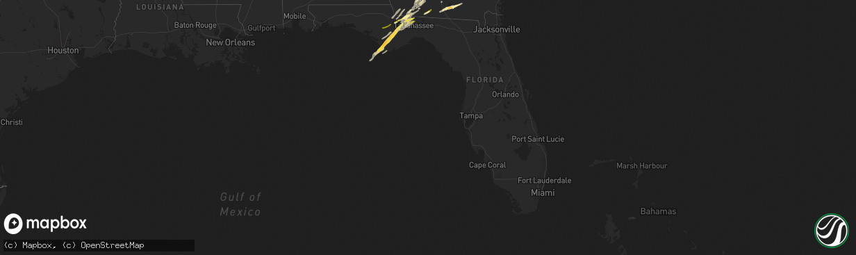
Hail
9,403
Estimated number of impacted properties by a 1.00" hail or larger581
Estimated number of impacted properties by a 1.75" hail or larger0
Estimated number of impacted properties by a 2.50" hail or largerStorm reports in Florida
Florida
| Date | Description |
|---|---|
| 03/26/20242:33 PM CDT | Picture of large hail along salem road. |
| 03/26/20242:21 PM CDT | Corrects previous hail report from douglas city. Report of mostly penny size hail near the intersection of highway 90 and highway 12... But a few stones were up to quar |
| 03/26/20246:00 AM CDT | Picture of hail estimated at 2 inches in diameter from white city. |
| 03/26/20245:57 AM CDT | Picture of hail near ping pong ball size from the second hail storm. |
| 03/26/20245:36 AM CDT | A local report indicates 1.00 inch wind near Port Saint Joe |
| 03/26/20245:36 AM CDT | A local report indicates 1.00 inch wind near Ward Ridge |
| 03/26/20245:15 AM CDT | Picture of quarter size hail from northwest tallahassee area. |
| 03/26/20245:12 AM CDT | A local report indicates 1.00 inch wind near 1 S Forest Meadows Park |
| 03/26/20241:32 AM CDT | A local report indicates 1.00 inch wind near Hosford |
| 03/26/202412:50 AM CDT | Quarter-sized hail reported in dalkeith... Fl. |
| 03/26/202412:48 AM CDT | Dime to quarter size hail reported. |
| 03/26/202412:42 AM CDT | A local report indicates 1.00 inch wind near White City |
| 03/26/202412:39 AM CDT | Viewer reported up to quarter size hail in the white city area. |
| 03/26/202412:25 AM CDT | A local report indicates 1.00 inch wind near Milltown |
| 03/25/202410:30 PM CDT | Report of 1 inch hail from southern gadsden county via social media. |
All States Impacted by Hail Map on March 26, 2024
Cities Impacted by Hail Map on March 26, 2024
- Moultrie, GA
- Adel, GA
- Norman Park, GA
- Sparks, GA
- Lenox, GA
- Nashville, GA
- Alapaha, GA
- Ellenton, GA
- Willacoochee, GA
- Quincy, FL
- Havana, FL
- Whigham, GA
- Attapulgus, GA
- Grand Ridge, FL
- Sneads, FL
- Bainbridge, GA
- Cairo, GA
- Brinson, GA
- Chattahoochee, FL
- Donalsonville, GA
- Tallahassee, FL
- Clarksville, FL
- Blountstown, FL
- Bristol, FL
- Greensboro, FL
- Gretna, FL
- Climax, GA
- Hosford, FL
- Pearson, GA
- Thomasville, GA
- Boston, GA
- Dixie, GA
- Sylvester, GA
- Midway, FL
- Cadwell, GA
- Adrian, GA
- East Dublin, GA
- Glenwood, GA
- Rockledge, GA
- Dublin, GA
- Port Saint Joe, FL
- Kite, GA
- Wewahitchka, FL
- Swainsboro, GA
- Valdosta, GA
- Naylor, GA
- Lakeland, GA
- Stockton, GA
- Du Pont, GA
- Homerville, GA
- Ochlocknee, GA
- Meigs, GA
- Pelham, GA
- Sale City, GA
- Hartsfield, GA
- Camilla, GA
- Doerun, GA
- Coolidge, GA
- Sopchoppy, FL
- Sumner, GA
- Ty Ty, GA
- Omega, GA
- Tifton, GA
- Poulan, GA
- Ashburn, GA
- Sycamore, GA
- Rebecca, GA
- Rochelle, GA
- Abbeville, GA
- Pitts, GA
- Fitzgerald, GA
- Rhine, GA
- Eastman, GA
- Rentz, GA
- Baconton, GA
- Albany, GA
- Lyons, GA
- Hahira, GA
- Louisville, GA
- Midville, GA
- Eastpoint, FL
- Cassatt, SC
- Lugoff, SC
- Elgin, SC
- Chula, GA
- Apalachicola, FL


