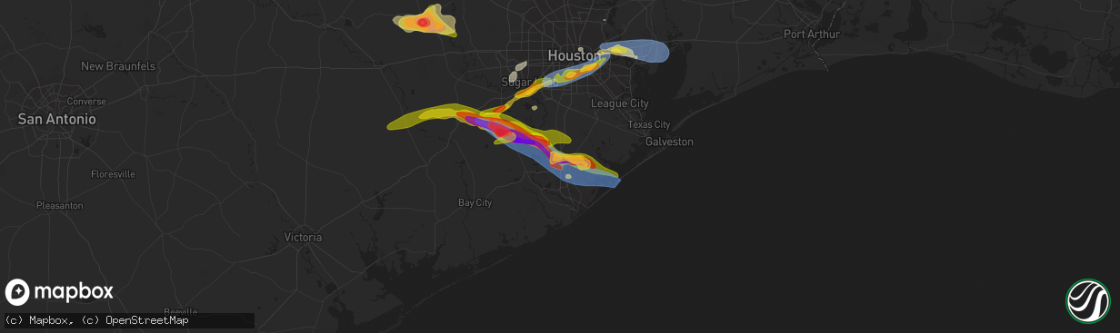
Hail Map in Angleton, TX on March 15, 2024
The weather event in Angleton, TX on March 15, 2024 includes Hail, Wind, and Tornado maps. 9 states and 248 cities were impacted and suffered possible damage. The total estimated number of properties impacted is 4,226.
Hail
Wind
Tornado
4,226
Estimated number of impacted properties by a 1.00" hail or larger3,290
Estimated number of impacted properties by a 1.75" hail or larger0
Estimated number of impacted properties by a 2.50" hail or largerStorm reports in Angleton, TX
Angleton, TX
| Date | Description |
|---|---|
| 03/15/20246:36 PM CDT | A local report indicates 66 MPH wind near 4 SSE Bailey's Prairie |
| 03/15/20246:29 PM CDT | A local report indicates 1.75 inch wind near 3 NNE Angleton |
| 03/15/20246:27 PM CDT | A local report indicates 1.00 inch wind near 3 NNW Angleton |
| 03/15/20246:21 PM CDT | Asos station klbx brazoria county airport. |
| 03/15/20246:15 PM CDT | Handheld anemometer measurement. |
| 03/15/20246:15 PM CDT | Weather station at angleton police station. Sustained 53 mph w/ gust to 75 mph. |
| 03/15/20246:11 PM CDT | Power lines and trees down at brazoria county fairgrounds. Time estimated by radar. |
| 03/15/20246:11 PM CDT | Large tree uprooted and knocked down wood fencing. |
All States Impacted by Hail Map on March 15, 2024
All Cities Impacted by Hail Map on March 15, 2024
- Beaver Falls, PA
- New Brighton, PA
- Zelienople, PA
- Fombell, PA
- Rochester, PA
- Iron City, TN
- Westpoint, TN
- Loretto, TN
- Lawrenceburg, TN
- Mount Carmel, IL
- Saint Francisville, IL
- Allendale, IL
- Sumner, IL
- Vincennes, IN
- Hazleton, IN
- Decker, IN
- Monroe City, IN
- Sonora, TX
- Eldorado, TX
- Christoval, TX
- Kermit, TX
- Ozona, TX
- Menard, TX
- Eden, TX
- Big Lake, TX
- Melvin, TX
- Brady, TX
- Junction, TX
- Oxford, AL
- Delta, AL
- Munford, AL
- Anniston, AL
- Heflin, AL
- London, TX
- Rochelle, TX
- Mason, TX
- Goldthwaite, TX
- San Saba, TX
- Fredonia, TX
- Pontotoc, TX
- Art, TX
- Valley Spring, TX
- Tuskegee, AL
- Union Springs, AL
- Fort McKavett, TX
- Jemison, AL
- Thorsby, AL
- Clanton, AL
- Franklin, TX
- Shorter, AL
- Pike Road, AL
- Montgomery, AL
- Notrees, TX
- Goldsmith, TX
- Calliham, TX
- Hamilton, TX
- Evant, TX
- Mullin, TX
- Richland Springs, TX
- Thrall, TX
- Elgin, TX
- Plains, TX
- Tilden, TX
- Mathews, AL
- Fitzpatrick, AL
- Philadelphia, MS
- Louisville, MS
- Lohn, TX
- Lexington, TX
- Raleigh, MS
- Cherokee, TX
- San Antonio, TX
- La Grange, TX
- Ledbetter, TX
- Giddings, TX
- Adkins, TX
- Georgiana, AL
- Red Level, AL
- Brantley, AL
- Greenville, AL
- Fort Mitchell, AL
- Cusseta, GA
- Omaha, GA
- Richland, GA
- Buena Vista, GA
- Ellaville, GA
- Oglethorpe, GA
- New Ulm, TX
- Cat Spring, TX
- Bellville, TX
- Sealy, TX
- La Vernia, TX
- Seguin, TX
- Stockdale, TX
- Dozier, AL
- Andersonville, GA
- Beasley, TX
- Rosenberg, TX
- Montezuma, GA
- Byromville, GA
- Americus, GA
- Shiner, TX
- Hallettsville, TX
- Brookshire, TX
- Vienna, GA
- Pinehurst, GA
- Needville, TX
- Richmond, TX
- Sugar Land, TX
- Missouri City, TX
- Pineview, GA
- Hawkinsville, GA
- Rochelle, GA
- Stafford, TX
- Brackettville, TX
- Houston, TX
- Abbeville, GA
- Eastman, GA
- Sour Lake, TX
- Beaumont, TX
- Rhine, GA
- Chauncey, GA
- Lumberton, TX
- Milan, GA
- Kountze, TX
- Del Rio, TX
- Laughlin Afb, TX
- Sublime, TX
- Galena Park, TX
- Pasadena, TX
- Uvalde, TX
- Guy, TX
- Omega, GA
- Tifton, GA
- Alamo, GA
- Lumber City, GA
- Damon, TX
- Leesburg, GA
- De Soto, GA
- Lenox, GA
- Rosharon, TX
- Channelview, TX
- Baytown, TX
- Highlands, TX
- Warwick, GA
- Angleton, TX
- Ariton, AL
- Brundidge, AL
- Opelika, AL
- Salem, AL
- Wetumpka, AL
- Round Top, TX
- Eufaula, AL
- Midway, AL
- Skipperville, AL
- McKenzie, AL
- Moultrie, GA
- Doerun, GA
- Sumner, GA
- Norman Park, GA
- Wharton, TX
- Fayetteville, TX
- Devers, TX
- Hempstead, TX
- Hardaway, AL
- Clio, AL
- Brenham, TX
- Vredenburgh, AL
- Whatley, AL
- Franklin, AL
- Hurtsboro, AL
- Chappell Hill, TX
- Industry, TX
- Lumpkin, GA
- Katy, TX
- Phenix City, AL
- Seale, AL
- Hatchechubbee, AL
- Dublin, GA
- Wallis, TX
- East Bernard, TX
- Gonzales, TX
- Elmendorf, TX
- Moulton, TX
- Ramer, AL
- Hope Hull, AL
- Burton, TX
- Liberty, TX
- Vidor, TX
- Hull, TX
- Winslow, AZ
- Danbury, TX
- Freeport, TX
- Clute, TX
- Lake Jackson, TX
- Galveston, TX
- Laredo, TX
- San Ygnacio, TX
- Alapaha, GA
- Clopton, AL
- Abbeville, AL
- Deer Park, TX
- La Porte, TX
- Quemado, TX
- Boling, TX
- Rebecca, GA
- Ashburn, GA
- Tallassee, AL
- Fitzgerald, GA
- Hebbronville, TX
- Zapata, TX
- Garwood, TX
- El Campo, TX
- Louise, TX
- Eagle Lake, TX
- Columbus, TX
- Alleyton, TX
- Louin, MS
- Monroeville, AL
- McRae Helena, GA
- Weimar, TX
- Schulenburg, TX
- Laurel, MS
- Encino, TX
- Garciasville, TX
- Rio Grande City, TX
- Sarita, TX
- Linn, TX
- Raymondville, TX
- Midfield, TX
- Lyford, TX
- Armstrong, TX
- San Perlita, TX
- Falfurrias, TX
- Roma, TX
- Lolita, TX
- West Columbia, TX
- Edinburg, TX
- Blessing, TX
- Hargill, TX
- Port Mansfield, TX
- Alvin, TX
- Liverpool, TX
- San Isidro, TX
- Guerra, TX
- Santa Fe, TX
- Glen Flora, TX
- Harlingen, TX


