Hail Map in Kentucky on March 14, 2024
The weather event in Kentucky on March 14, 2024 includes Hail, Wind, and Tornado maps. 15 states and 1,835 cities were impacted and suffered possible damage. The total estimated number of properties impacted is 22,976.
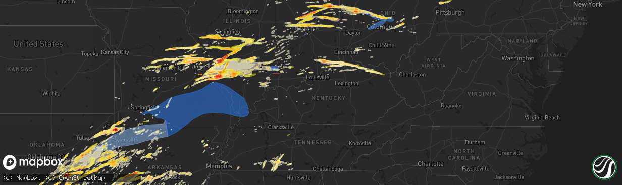
Hail
Wind
Tornado
22,976
Estimated number of impacted properties by a 1.00" hail or larger9,693
Estimated number of impacted properties by a 1.75" hail or larger0
Estimated number of impacted properties by a 2.50" hail or largerStorm reports in Kentucky
Kentucky
| Date | Description |
|---|---|
| 03/14/20243:35 PM CDT | Tree limbs down - time estimated. |
| 03/14/20243:18 PM CDT | Tree down on car - time estimated. |
| 03/14/20242:15 PM CDT | Numerous reports of hail across the county... Largest was around quarter sized -- time estimated. |
| 03/14/20242:15 PM CDT | Photo verified. Time estimated. |
| 03/14/20242:05 PM CDT | A local report indicates 2.00 inch wind near 5 E Glencoe |
| 03/14/20242:04 PM CDT | Via mping. Time estimated. |
| 03/14/20241:40 PM CDT | A local report indicates 1.00 inch wind near Warsaw |
| 03/14/20241:25 PM CDT | A local report indicates 68 MPH wind near 1 ENE Carrollton |
| 03/14/20241:22 PM CDT | Damage to structures. Likely tornado. Time estimated. |
| 03/14/20241:08 PM CDT | Ef2 tornado with winds to 115 mph confirmed in carroll county ky and switzerland county in in the nws wilmington oh forecast area. This tornado also affected portions o |
| 03/14/202410:46 AM CDT | Power lines down on the 4500 block of state road 86... Just outside of custer. |
| 03/14/202410:46 AM CDT | Trees down on the 3000 block of state road 1638. Trees have since been removed. |
| 03/14/202412:40 AM CDT | Bath county dispatch reported a tree blown down onto telephone lines near the intersection of us-60 and moores ferry road. Time estimated from radar. |
| 03/14/202412:30 AM CDT | Montgomery county dispatch reported tree blown down by thunderstorm wind gusts. Tree was blocking nest egg road near the intersection of summer ridge road. |
| 03/13/202411:39 PM CDT | Two trees down in the monroe community. |
| 03/13/202411:30 PM CDT | Large tree down on miller road. |
| 03/13/202411:29 PM CDT | Tree down in the linwood community. |
| 03/13/202411:18 PM CDT | A local report indicates 1.00 inch wind near Bloomfield |
| 03/13/202411:13 PM CDT | Tree down on valley creek road. |
| 03/13/202411:12 PM CDT | Trees downed with rocks and trees in the roadway on state route 355. Time estimated from radar. |
| 03/13/202411:09 PM CDT | Roof off building and power poles down on state route 22. Time estimated from radar. |
| 03/13/202411:02 PM CDT | Tree down on hardinsburg road. |
| 03/13/202410:46 PM CDT | Corrects time of previous tstm wnd dmg report from 4 nne garrett. Trees down on the 3000 block of state road 1638. Trees have since been removed. |
| 03/13/202410:46 PM CDT | Power lines down on the 4500 block of state road 86. |
| 03/13/202410:42 PM CDT | Tree across rosetta road near stinnettsville. |
| 03/13/202410:42 PM CDT | A local report indicates 1.00 inch wind near 2 SE Highview |
| 03/13/202410:41 PM CDT | Trees down in the area of us 60 and state road 428. Trees have since been removed. |
| 03/13/202410:30 PM CDT | Tin roof removed off of a building in whitesville. Only visible wind damage in the area. Some minor hail damage also reported in the area. |
| 03/13/202410:28 PM CDT | Spotter measured 75 mph gust on i-24 at ky hwy 107. |
| 03/13/202410:28 PM CDT | Spotter me |
| 03/13/202410:10 PM CDT | A local report indicates 62 MPH wind near 1 SSW Hardinsburg |
| 03/13/20249:54 PM CDT | Corrects time for previous hail report from 2 se highview. |
| 03/13/20249:53 PM CDT | A local report indicates 1.00 inch wind near 3 SSE Highview |
| 03/13/20249:51 PM CDT | A local report indicates 1.00 inch wind near 2 N Bedford |
| 03/13/20249:04 PM CDT | Power lines down on home and trees down on strathmoor drive in paducah. Also power outages reported on n 8th street in paducah and in the st. Johns area of mccracken co |
| 03/13/20248:55 PM CDT | Trees and power lines down across the county... Including in the folsomdale... Hickory... And viola areas. Time estimated by radar. |
| 03/13/20248:53 PM CDT | Metal roof removed from a building on north 8th street in paducah. Numerous powerlines downed in the area as well. Radar and damage consistent with a small area of enha |
| 03/13/20248:38 PM CDT | Roof blown off a barn on phelps road in southeast ballard county. Time estimated from radar. |
| 03/13/20248:35 PM CDT | Power outages in the cunningham area and northwest of bardwell. Reports of trees down in both areas. |
| 03/13/20248:34 PM CDT | Corrects previous tstm wnd dmg report from 3 w paducah start time. Sporadic damage consistent with 70-75 mph wind gusts were found from near cunningham... Ky to the nor |
| 03/13/20248:03 PM CDT | Sporadic damage consistent with 70-75 mph wind gusts were found from near cunningham... Ky to the north side of paducah near 8th street. The damage was not oriented con |
All States Impacted by Hail Map on March 14, 2024
Cities Impacted by Hail Map on March 14, 2024
- Saint Augustine, IL
- Abingdon, IL
- Avon, IL
- Prairie City, IL
- Berwick, IL
- Eureka, KS
- Hamilton, KS
- Virgil, KS
- Gridley, KS
- Madison, KS
- Toronto, KS
- Yates Center, KS
- Burlington, KS
- Le Roy, KS
- Westphalia, KS
- Garnett, KS
- Waverly, KS
- Piqua, KS
- Downs, IL
- Le Roy, IL
- Ellsworth, IL
- Mora, MO
- Smithton, MO
- Florence, MO
- Otterville, MO
- Syracuse, MO
- Fortuna, MO
- Tipton, MO
- Clarksburg, MO
- Saint Anne, IL
- Momence, IL
- Kankakee, IL
- California, MO
- Latham, MO
- Pembroke Township, IL
- Lake Village, IN
- Schneider, IN
- Lowell, IN
- Tower Hill, IL
- Shelbyville, IL
- Lakewood, IL
- Martinsville, IL
- Annapolis, IL
- West York, IL
- West Union, IL
- Jefferson City, MO
- Holts Summit, MO
- Tebbetts, MO
- Indianapolis, IN
- Camby, IN
- Comanche, OK
- Duncan, OK
- Waurika, OK
- Macomb, OK
- Asher, OK
- Maud, OK
- Tecumseh, OK
- Marlow, OK
- Foster, OK
- Henrietta, TX
- Elmore City, OK
- Lindsay, OK
- Maysville, OK
- Pauls Valley, OK
- Ringling, OK
- Loco, OK
- Shawnee, OK
- Prague, OK
- Wetumka, OK
- Weleetka, OK
- Okemah, OK
- Henryetta, OK
- Okmulgee, OK
- Ringgold, TX
- Paris Crossing, IN
- Commiskey, IN
- Deputy, IN
- Madison, IN
- Lexington, IN
- Morris, OK
- Chouteau, OK
- Chamois, MO
- Twelve Mile, IN
- Arthur, IL
- Oblong, IL
- Star City, IN
- Kewanna, IN
- Crothersville, IN
- Brookston, IN
- Jasonville, IN
- Sullivan, IN
- Demotte, IN
- Farmersburg, IN
- Lewis, IN
- Shelburn, IN
- Terre Haute, IN
- Pimento, IN
- Odon, IN
- Newberry, IN
- Elnora, IN
- West Terre Haute, IN
- Sheldon, IL
- Kentland, IN
- Sedalia, MO
- Green Ridge, MO
- Ryan, OK
- Brazil, IN
- Earlsboro, OK
- Seminole, OK
- Cole Camp, MO
- Rosedale, IN
- Wanette, OK
- Herscher, IL
- Bonfield, IL
- Akron, IN
- Macy, IN
- Willow Hill, IL
- Yale, IL
- Clinton, IN
- Riley, IN
- New Goshen, IN
- Wewoka, OK
- Georgetown, IL
- Ridge Farm, IL
- Indianola, IL
- Castle, OK
- Wheatfield, IN
- Rensselaer, IN
- Fair Oaks, IN
- Paris, IL
- Wolcott, IN
- Mooresville, IN
- Monrovia, IN
- Chrisman, IL
- Holdenville, OK
- Freelandville, IN
- Sandborn, IN
- Oaktown, IN
- Bicknell, IN
- Edwardsport, IN
- Sullivan, IL
- Lovington, IL
- Paoli, OK
- Wayne, OK
- Byars, OK
- Francesville, IN
- Winamac, IN
- Byers, TX
- Vincennes, IN
- Plainville, IN
- Earl Park, IN
- Goodland, IN
- Ada, OK
- Aroma Park, IL
- Cook Sta, MO
- Onarga, IL
- Bainbridge, IN
- Roachdale, IN
- Lexington, OK
- Montezuma, IN
- Hillsdale, IN
- Pryor, OK
- Hanover, IN
- Milton, KY
- Nocona, TX
- Terral, OK
- Wynnewood, OK
- Stratford, OK
- Locust Grove, OK
- Boynton, OK
- Salina, OK
- Haskell, OK
- Vevay, IN
- Spavinaw, OK
- Porter, OK
- Taft, OK
- Gore, OK
- Jay, OK
- Vian, OK
- Grove, OK
- Park Hill, OK
- Cookson, OK
- Davis, OK
- Muskogee, OK
- South West City, MO
- Eucha, OK
- Colcord, OK
- Ghent, KY
- Florence, IN
- Warsaw, KY
- Sparta, KY
- Sanders, KY
- Glencoe, KY
- Dry Ridge, KY
- Carrollton, KY
- Sulphur, OK
- Anderson, MO
- Verona, KY
- Roff, OK
- Crittenden, KY
- Williamstown, KY
- Tahlequah, OK
- De Mossville, KY
- Falmouth, KY
- Wagoner, OK
- Gravette, AR
- Maysville, AR
- Sulphur Springs, AR
- Patriot, IN
- Butler, KY
- Foster, KY
- Eufaula, OK
- Checotah, OK
- Noel, MO
- Brooksville, KY
- Oktaha, OK
- Bella Vista, AR
- Hiwasse, AR
- Pineville, MO
- West Jefferson, OH
- London, OH
- Plain City, OH
- Hilliard, OH
- Dublin, OH
- Amlin, OH
- Galloway, OH
- Columbus, OH
- Lewis Center, OH
- Westerville, OH
- Galena, OH
- Powell, OH
- New Albany, OH
- Fort Gibson, OK
- Hulbert, OK
- Augusta, KY
- Germantown, KY
- Welling, OK
- Proctor, OK
- Mayslick, KY
- Mount Olivet, KY
- Maysville, KY
- Dover, KY
- Braggs, OK
- Bunch, OK
- Westville, OK
- Stilwell, OK
- Kansas, OK
- Watts, OK
- Stigler, OK
- Mokane, MO
- Steedman, MO
- Centralia, MO
- Sturgeon, MO
- Decatur, AR
- Gentry, AR
- Summers, AR
- Siloam Springs, AR
- Harrisburg, MO
- Fayetteville, AR
- Canehill, AR
- Lincoln, AR
- Evansville, AR
- Thompson, MO
- Mexico, MO
- Portland, MO
- Rhineland, MO
- Hermann, MO
- Springdale, AR
- Bentonville, AR
- Winslow, AR
- Prairie Grove, AR
- Farmington, AR
- West Fork, AR
- Morrow, AR
- Tollesboro, KY
- Rogers, AR
- Cave Springs, AR
- Lowell, AR
- Pea Ridge, AR
- Centerton, AR
- Bunceton, MO
- Pilot Grove, MO
- Berryville, AR
- Prairie Home, MO
- Boonville, MO
- Green Forest, AR
- Warrenton, MO
- Marthasville, MO
- Jonesburg, MO
- Goodman, MO
- Sullivan, MO
- Lonedell, MO
- Richwoods, MO
- Bourbon, MO
- Luebbering, MO
- Grubville, MO
- Dittmer, MO
- Elkins, AR
- Garfield, AR
- Laddonia, MO
- Rush Hill, MO
- Farber, MO
- Curryville, MO
- Vandalia, MO
- Porum, OK
- Middletown, MO
- Bowling Green, MO
- Mill Creek, OK
- Tishomingo, OK
- Pittsfield, IL
- Pearl, IL
- Winchester, IL
- Wallingford, KY
- Vanceburg, KY
- Hillsboro, MO
- Stonewall, OK
- Truesdale, MO
- Wright City, MO
- Foristell, MO
- Wentzville, MO
- Clever, MO
- Nixa, MO
- Ozark, MO
- Sparta, MO
- Montgomery City, MO
- Rogersville, MO
- New Florence, MO
- Fordland, MO
- Bruner, MO
- Wooldridge, MO
- Jamestown, MO
- Columbia, MO
- Oldfield, MO
- Seymour, MO
- Ava, MO
- Squires, MO
- Mansfield, MO
- Ashland, MO
- Clarksville, MO
- Sallisaw, OK
- Nebo, IL
- Eolia, MO
- Lake Saint Louis, MO
- O'Fallon, MO
- Pevely, MO
- Barnhart, MO
- Festus, MO
- Herculaneum, MO
- Webbers Falls, OK
- Waterloo, IL
- Smithton, IL
- New Athens, IL
- Tupelo, OK
- Golden Eagle, IL
- Saint Charles, MO
- Saint Peters, MO
- Drury, MO
- Norwood, MO
- Macomb, MO
- Mountain Grove, MO
- Marshfield, MO
- Hartville, MO
- Oak Grove, AR
- Lead Hill, AR
- Alpena, AR
- Omaha, AR
- Wesley, AR
- Eureka Springs, AR
- Hindsville, AR
- Huntsville, AR
- Lampe, MO
- Cedarcreek, MO
- Eagle Rock, MO
- Golden, MO
- Branson, MO
- Shell Knob, MO
- Hollister, MO
- Ridgedale, MO
- Blue Eye, MO
- Kirbyville, MO
- Marble Falls, AR
- Compton, AR
- Kingston, AR
- Ponca, AR
- Combs, AR
- Witter, AR
- Jasper, AR
- Harrison, AR
- Reeds Spring, MO
- Olive Hill, KY
- Emerson, KY
- Rockaway Beach, MO
- Grayson, KY
- Fulton, MO
- High Hill, MO
- Bellflower, MO
- Truxton, MO
- Hawk Point, MO
- Troy, MO
- Elsberry, MO
- Annada, MO
- Jacksonville, IL
- Murrayville, IL
- Woodson, IL
- Franklin, IL
- Waverly, IL
- Virden, IL
- Granite City, IL
- Konawa, OK
- Edwardsville, IL
- Williamsburg, MO
- Collinsville, IL
- Glen Carbon, IL
- Maryville, IL
- Troy, IL
- Valmeyer, IL
- Fults, IL
- Lynchburg, MO
- Grovespring, MO
- Graff, MO
- Plato, MO
- Huggins, MO
- Cabool, MO
- Houston, MO
- Vanzant, MO
- Solo, MO
- Bucyrus, MO
- Willow Springs, MO
- Elk Creek, MO
- Dora, MO
- Yellville, AR
- Theodosia, MO
- Rueter, MO
- Isabella, MO
- Protem, MO
- Kissee Mills, MO
- Peel, AR
- Oakland, AR
- Everton, AR
- Western Grove, AR
- Pyatt, AR
- Marine, IL
- Keota, OK
- La Fontaine, IN
- Bunker Hill, IN
- Marion, IN
- Miami, IN
- Highland, IL
- Amboy, IN
- Van Buren, IN
- Aviston, IL
- Warren, IN
- Montpelier, IN
- Trenton, IL
- Converse, IN
- Peru, IN
- Gans, OK
- Muldrow, OK
- Portage Des Sioux, MO
- Red Bud, IL
- Florissant, MO
- Hecker, IL
- Freeburg, IL
- Kinta, OK
- Auburn, IL
- Divernon, IL
- Pawnee, IL
- Thayer, IL
- Mascoutah, IL
- Belleville, IL
- Lenzburg, IL
- Mccurtain, OK
- Poneto, IN
- Liberty Center, IN
- Bluffton, IN
- Lebanon, IL
- Morrisonville, IL
- Potosi, MO
- Carrollton, IL
- Summerfield, IL
- Kane, IL
- Eldred, IL
- Centrahoma, OK
- Rockbridge, IL
- Saint James, MO
- Steelville, MO
- Coalgate, OK
- Greenfield, IL
- Frankfort, IN
- Colfax, IN
- Chesterfield, IL
- Medora, IL
- Saint Louis, MO
- Michigantown, IN
- Arnold, MO
- Imperial, MO
- East Alton, IL
- Wardville, OK
- South Roxana, IL
- Hartford, IL
- Stuart, OK
- Pocahontas, IL
- Fenton, MO
- Mcalester, OK
- Worden, IL
- Alhambra, IL
- Hamel, IL
- New Douglas, IL
- Livingston, IL
- East Carondelet, IL
- Blackwell, MO
- De Soto, MO
- Fletcher, MO
- Keystone, IN
- Geneva, IN
- Marietta, OK
- Roxana, IL
- Kiowa, OK
- Berne, IN
- Beulah, MO
- Edgar Springs, MO
- Lenox, MO
- Roby, MO
- Salem, MO
- Success, MO
- Licking, MO
- Raymondville, MO
- Jadwin, MO
- Eminence, MO
- Summersville, MO
- Yukon, MO
- Eunice, MO
- Hartshorn, MO
- Birch Tree, MO
- Mountain View, MO
- Caulfield, MO
- Peace Valley, MO
- Pomona, MO
- West Plains, MO
- Moody, MO
- Pottersville, MO
- Bakersfield, MO
- Elizabeth, AR
- Tecumseh, MO
- Gamaliel, AR
- Gepp, AR
- Henderson, AR
- Zanoni, MO
- Brixey, MO
- Bull Shoals, AR
- Gainesville, MO
- Gassville, AR
- Cotter, AR
- Flippin, AR
- Norfork, AR
- Summit, AR
- Lakeview, AR
- Valley Springs, AR
- Pontiac, MO
- Mountain Home, AR
- Saint Joe, AR
- Midway, AR
- Udall, MO
- Clarkridge, AR
- Calico Rock, AR
- Wasola, MO
- Hardenville, MO
- Thornfield, MO
- Prairie Du Rocher, IL
- Kempton, IN
- Forest, IN
- Russiaville, IN
- Tipton, IN
- Sharpsville, IN
- Taylorville, IL
- Bulpitt, IL
- Kincaid, IL
- Edinburg, IL
- Tovey, IL
- Goldsmith, IN
- Assumption, IL
- Stonington, IL
- Hettick, IL
- Carlinville, IL
- Rudy, AR
- Mountainburg, AR
- Columbia, IL
- Chester, AR
- Fort Smith, AR
- Barling, AR
- Lavaca, AR
- Alma, AR
- Van Buren, AR
- Dupo, IL
- Petroleum, IN
- Gillespie, IL
- Gainesville, TX
- Bokoshe, OK
- Spiro, OK
- Marissa, IL
- Addieville, IL
- Saint Libory, IL
- Litchfield, IL
- Shipman, IL
- O'Fallon, IL
- Haslet, TX
- Madill, OK
- Fort Worth, TX
- Rockford, OH
- Celina, OH
- Mendon, OH
- Hartford City, IN
- Cameron, OK
- Wabash, IN
- Inola, OK
- Wellsville, MO
- Fieldon, IL
- Kokomo, IN
- Ossian, IN
- Decatur, IN
- South Greenfield, MO
- Galveston, IN
- Walton, IN
- Markle, IN
- Walnut Shade, MO
- Dustin, OK
- Peebles, OH
- Brussels, IL
- Afton, OK
- Vinita, OK
- Thorntown, IN
- Darlington, IN
- Bradleyville, MO
- Healdton, OK
- Graham, OK
- Ratliff City, OK
- Springer, OK
- Scottsburg, IN
- Austin, IN
- Flemingsburg, KY
- Dupont, IN
- New Berlin, IL
- Scott Air Force Base, IL
- East Saint Louis, IL
- Greentown, IN
- Poteau, OK
- Huntington, IN
- Ladoga, IN
- Chelsea, OK
- Talala, OK
- Oologah, OK
- Sasakwa, OK
- Adair, OK
- Lebanon, IN
- Kirklin, IN
- Rose, OK
- Crystal City, MO
- Schell City, MO
- Monett, MO
- Purdy, MO
- Pierce City, MO
- Canadian, OK
- Hanna, OK
- Bryant, IN
- Pennville, IN
- Eldridge, MO
- Lebanon, MO
- Stoutland, MO
- Depew, OK
- Bristow, OK
- Ozark, AR
- Lamar, MO
- Auxvasse, MO
- Kingdom City, MO
- Broken Arrow, OK
- Strang, OK
- McCune, KS
- Cedarville, AR
- Aurora, MO
- Saint Jacob, IL
- Smithville, OK
- Heavener, OK
- Boles, AR
- Mena, AR
- West Alton, MO
- Powell, MO
- Washburn, MO
- Rocky Comfort, MO
- Forsyth, MO
- Taneyville, MO
- Venice, IL
- Caseyville, IL
- Lovejoy, IL
- Madison, IL
- Crawfordsville, IN
- New Bloomfield, MO
- Council Hill, OK
- Fitzhugh, OK
- Tunas, MO
- Buffalo, MO
- Milburn, OK
- White Hall, IL
- Kampsville, IL
- Liberal, MO
- Mindenmines, MO
- Windfall, IN
- Lanagan, MO
- Stella, MO
- Montreal, MO
- Mount Judea, AR
- Vendor, AR
- Galena, MO
- Kimberling City, MO
- Lagro, IN
- Bethany, IL
- Paden, OK
- Milton, IL
- Wood River, IL
- Rockville, MO
- Garrison, MO
- Chadwick, MO
- New Baden, IL
- Germantown, IL
- Bartelso, IL
- Carlyle, IL
- Albers, IL
- Camdenton, MO
- Billings, MO
- Natural Dam, AR
- Broken Bow, OK
- Ionia, MO
- Warner, OK
- Walnut, KS
- Saint Paul, KS
- Girard, KS
- Seligman, MO
- Fairview, MO
- Neosho, MO
- Stark City, MO
- Highlandville, MO
- La Russell, MO
- Chatham, IL
- Roanoke, TX
- Beggs, OK
- Indianola, OK
- Bowlegs, OK
- Uniontown, AR
- Whitefield, OK
- Swayzee, IN
- Jonesboro, IN
- Fairmount, IN
- Savanna, OK
- Butler, IL
- Moweaqua, IL
- Hillsboro, IL
- Argyle, TX
- Irving, IL
- Witt, IL
- Keller, TX
- Fort Jennings, OH
- Ottoville, OH
- Flower Mound, TX
- Krebs, OK
- Charleston, AR
- Findlay, IL
- Calvin, OK
- Saint Marys, OH
- Gas City, IN
- Mulberry, AR
- Windsor, IL
- Gays, IL
- Jamestown, IN
- Allen, OK
- Mattoon, IL
- Charleston, IL
- Sheridan, IN
- Atlanta, IN
- Nokomis, IL
- Fillmore, IL
- Arcadia, IN
- Denton, TX
- Waldron, AR
- Parks, AR
- Lewisville, TX
- Harvey, AR
- Hartshorne, OK
- Strasburg, IL
- Lamar, OK
- Ashmore, IL
- Findlay, OH
- Atwood, OK
- Coleman, OK
- Wapanucka, OK
- Caddo Gap, AR
- Norman, AR
- Lake Dallas, TX
- Little Elm, TX
- Aubrey, TX
- Fostoria, OH
- Arcadia, OH
- Alvada, OH
- Wapakoneta, OH
- New Riegel, OH
- Carey, OH
- Tiffin, OH
- Uniopolis, OH
- Whitestown, IN
- Zionsville, IN
- Dover, AR
- Pelsor, AR
- Carmel, IN
- Westfield, IN
- Noblesville, IN
- Gravelly, AR
- Bluffton, AR
- Bloomville, OH
- Republic, OH
- Attica, OH
- Summitville, IN
- Alexandria, IN
- Gaston, IN
- Muncie, IN
- Yorktown, IN
- Albany, IN
- Eaton, IN
- Wilburton, OK
- Watson, OK
- Fishers, IN
- Red Oak, OK
- Quinton, OK
- Cove, AR
- Hatfield, AR
- Lakeview, OH
- Frisco, TX
- Sycamore, OH
- New Bremen, OH
- New Knoxville, OH
- Botkins, OH
- Jackson Center, OH
- Lewistown, OH
- Belle Center, OH
- Huntsville, OH
- Prosper, TX
- Celina, TX
- Hamilton, MS
- Farmland, IN
- Parker City, IN
- Winchester, IN
- Ridgeville, IN
- Aberdeen, MS
- Pendleton, IN
- Greenwood Springs, MS
- Amory, MS
- Advance, IN
- New Washington, OH
- Atoka, OK
- Smithville, MS
- Willard, OH
- Hamilton, AL
- Tremont, MS
- Fulton, MS
- Briggsville, AR
- Danville, AR
- Russells Point, OH
- Bingham, IL
- Bonnerdale, AR
- Mount Ida, AR
- Plymouth, OH
- Shelby, OH
- Tiro, OH
- Markleville, IN
- Crowder, OK
- Millstadt, IL
- Coulterville, IL
- Oakdale, IL
- Mckinney, TX
- Nashville, IL
- Ashley, IL
- Plainview, AR
- Vina, AL
- Golden, MS
- Red Bay, AL
- Anna, TX
- New Castle, IN
- Shirley, IN
- Middletown, IN
- Kenefic, OK
- Shiloh, OH
- Greenwich, OH
- Leadwood, MO
- Irondale, MO
- Mineral Point, MO
- Davisville, MO
- Bonne Terre, MO
- Valles Mines, MO
- Cherryville, MO
- Belgrade, MO
- Bismarck, MO
- Park Hills, MO
- Cadet, MO
- Boss, MO
- Belleview, MO
- Bixby, MO
- Centerville, MO
- Viburnum, MO
- Ellington, MO
- Caledonia, MO
- French Village, MO
- Black, MO
- Bunker, MO
- Piedmont, MO
- Koshkonong, MO
- Redford, MO
- Fremont, MO
- Annapolis, MO
- Middle Brook, MO
- Van Buren, MO
- Pilot Knob, MO
- Lesterville, MO
- Alton, MO
- Arcadia, MO
- Vulcan, MO
- Ironton, MO
- Farmington, MO
- Winona, MO
- Doe Run, MO
- Bexar, AR
- Couch, MO
- Thayer, MO
- Viola, AR
- Camp, AR
- Mammoth Spring, AR
- Sturkie, AR
- Brandsville, MO
- Dolph, AR
- Salem, AR
- Raymond, OH
- West Mansfield, OH
- Marysville, OH
- Broadway, OH
- Ridgeway, OH
- Rushsylvania, OH
- Bellefontaine, OH
- Zanesfield, OH
- East Liberty, OH
- Oakland, IL
- Richwood, OH
- Oden, AR
- Trilla, IL
- Lerna, IL
- Van Alstyne, TX
- Staunton, IL
- Sorento, IL
- Jessieville, AR
- Mountain Pine, AR
- Hot Springs Village, AR
- Walshville, IL
- Panama, IL
- Donnellson, IL
- Hagerstown, IN
- Mooreland, IN
- Losantville, IN
- Coffeen, IL
- Union City, IN
- Saratoga, IN
- Ostrander, OH
- Magnetic Springs, OH
- Radnor, OH
- Belmont, MS
- Raymond, IL
- Rosamond, IL
- Pana, IL
- Oconee, IL
- Ramsey, IL
- Delaware, OH
- Caddo, OK
- Caney, OK
- Economy, IN
- Williamsburg, IN
- Modoc, IN
- Pencil Bluff, AR
- Greenville, IL
- Mulberry Grove, IL
- Smithboro, IL
- Vandalia, IL
- Richview, IL
- Hoyleton, IL
- Pocola, OK
- Woodlawn, IL
- Mount Vernon, IL
- Opdyke, IL
- Bluford, IL
- Belle Rive, IL
- Keenes, IL
- Wayne City, IL
- Sims, IL
- Fairfield, IL
- Beaver Falls, PA
- Rochester, PA
- Fombell, PA
- New Brighton, PA
- Zelienople, PA
- Harmony, PA
- Evans City, PA
- Renfrew, PA
- Connoquenessing, PA
- Butler, PA
- Beaver, PA
- Whitewright, TX
- Bono, AR
- Paragould, AR
- Sunbury, OH
- Tioga, TX
- Howe, TX
- Gunter, TX
- Blue Ridge, TX
- Leonard, TX
- Trenton, TX
- Stringtown, OK
- Lane, OK
- Thornville, OH
- Jacksontown, OH
- Heath, OH
- Hebron, OH
- Lonsdale, AR
- Paron, AR
- Benton, AR
- Glenford, OH
- Mount Perry, OH
- Hopewell, OH
- Nashport, OH
- Alexander, AR
- Little Rock, AR
- Croton, OH
- Centerburg, OH
- Johnstown, OH
- Utica, OH
- Newark, OH
- Alexandria, OH
- Granville, OH
- Saint Louisville, OH
- Zanesville, OH
- Frazeysburg, OH
- Dresden, OH
- Sims, AR
- Arkadelphia, AR
- Leola, AR
- Malvern, AR
- Westpoint, TN
- Iron City, TN
- Lawrenceburg, TN
- Loretto, TN
- Randolph, TX
- Bonham, TX
- Prattsville, AR
- Poyen, AR
- Patoka, IN
- Princeton, IN
- Saint Paris, OH
- Urbana, OH
- Celeste, TX
- Klondike, TX
- Cooper, TX
- Francisco, IN
- Roland, AR
- Patterson, MO
- Mill Spring, MO
- Ellsinore, MO
- Des Arc, MO
- Fredericktown, MO
- Silva, MO
- Patton, MO
- Marquand, MO
- Lodi, MO
- Sainte Genevieve, MO
- Marble Hill, MO
- Greenville, MO
- Clubb, MO
- Glenallen, MO
- Wappapello, MO
- Williamsville, MO
- Grandin, MO
- Oran, MO
- Chaffee, MO
- Brownwood, MO
- Whitewater, MO
- Bloomsdale, MO
- Zalma, MO
- Leopold, MO
- McGee, MO
- Lowndes, MO
- Sturdivant, MO
- Gipsy, MO
- Advance, MO
- Perryville, MO
- Bloomfield, MO
- Puxico, MO
- Bell City, MO
- Scott City, MO
- Bertrand, MO
- Friedheim, MO
- Jackson, MO
- Oak Ridge, MO
- Cape Girardeau, MO
- Vanduser, MO
- Sikeston, MO
- Millersville, MO
- Benton, MO
- Charleston, MO
- Daisy, MO
- Burfordville, MO
- Sedgewickville, MO
- Saint Mary, MO
- Ava, IL
- Cobden, IL
- Jacob, IL
- Chester, IL
- Cairo, IL
- McClure, IL
- Altenburg, MO
- Rockwood, IL
- Villa Ridge, IL
- Mounds, IL
- Miller City, IL
- Anna, IL
- Uniontown, MO
- Old Appleton, MO
- Ullin, IL
- Jonesboro, IL
- Wolf Lake, IL
- Pomona, IL
- Carbondale, IL
- Alto Pass, IL
- Makanda, IL
- Gorham, IL
- Frohna, MO
- Olive Branch, IL
- Pulaski, IL
- Murphysboro, IL
- Grand Tower, IL
- Tamms, IL
- Dongola, IL
- Thebes, IL
- Farrar, MO
- Campbell Hill, IL
- Steeleville, IL
- Ellis Grove, IL
- Modoc, IL
- Grantsburg, IL
- Belknap, IL
- Karnak, IL
- Kevil, KY
- Bardwell, KY
- Metropolis, IL
- Grand Chain, IL
- La Center, KY
- Buncombe, IL
- Goreville, IL
- Barlow, KY
- Paducah, KY
- Mound City, IL
- Vienna, IL
- Cypress, IL
- Melber, KY
- West Paducah, KY
- Cunningham, KY
- Wickliffe, KY
- Olmsted, IL
- Florence, AL
- Jonesboro, AR
- Brookland, AR
- Brookston, TX
- Sumner, TX
- Wolfe City, TX
- Summertown, TN
- Ethridge, TN
- Mount Pleasant, TN
- Mount Carmel, IL
- Allendale, IL
- Decker, IN
- Sumner, IL
- Saint Francisville, IL
- Hazleton, IN
- Monroe City, IN
- Petersburg, IN
- Loogootee, IN
- Cannelburg, IN
- Shoals, IN
- Bedford, KY
- Ashland City, TN
- English, IN
- Marengo, IN
- Palmyra, IN
- Pattonville, TX
- Paris, TX
- Blossom, TX
- Deport, TX
- Detroit, TX
- Pekin, IN
- Borden, IN
- Greenville, IN
- Clarksville, TX
- Russellville, AL
- Union City, OH
- Portland, IN
- Arcanum, OH
- New Madison, OH
- Chesterfield, MO
- Reelsville, IN
- Carbon, IN
- Cloverdale, IN
- Greencastle, IN
- Flora, IL
- Silex, MO
- Westfield, IL
- Casey, IL
- Story, AR
- Girard, IL
- Palmyra, IL
- Columbus Grove, OH
- Pandora, OH
- Rawson, OH
- Ottawa, OH
- Bluffton, OH
- Mount Cory, OH
- Hillsboro, IN
- Anderson, IN
- Alamo, IN
- Lapel, IN
- Fortville, IN
- New Ross, IN
- Waynetown, IN
- Vermilion, IL
- Berger, MO
- Savannah, TN
- Olivehill, TN
- Murray, KY
- Hazel, KY
- Sulligent, AL
- Nettleton, MS
- Columbus, MS
- Detroit, AL
- West Point, MS
- Selma, IN
- Frankton, IN
- Elwood, IN
- Dunkirk, IN
- Upland, IN
- Pilot Point, TX
- Clinton, AR
- Dennard, AR
- Batchtown, IL
- Cory, IN
- Bagwell, TX
- Mansfield, AR
- Piqua, OH
- Sparkman, AR
- Carthage, AR
- Fillmore, IN
- Versailles, MO
- Barnett, MO
- Russellville, MO
- Warsaw, OH
- Gurdon, AR
- McComb, OH
- Marshall, IN
- Rockville, IN
- House Springs, MO
- Bonnie, IL
- Ina, IL
- Campbell, TX
- Commerce, TX
- Cumby, TX
- Defiance, MO
- Augusta, MO
- Worthington, IN
- Switz City, IN
- Versailles, OH
- Greenville, OH
- Bradford, OH
- Norris City, IL
- Carmi, IL
- New Harmony, IN
- Enfield, IL
- Wadesville, IN
- New Haven, IL
- Mount Vernon, IN
- Hackett, AR
- Greenwood, AR
- Uniondale, IN
- Clayton, OK
- Centerpoint, IN
- Merom, IN
- Bridgeport, IL
- Flat Rock, IL
- Lawrenceville, IL
- Claremont, IL
- Olney, IL
- Okawville, IL
- Centertown, MO
- Poseyville, IN
- Evansville, IN
- Haubstadt, IN
- Batavia, OH
- Centralia, IL
- Pittsburg, OK
- Blanco, OK
- Lamar, AR
- Ardmore, OK
- Mannsville, OK
- Daisy, OK
- Hagarville, AR
- Carlisle, IN
- Palestine, IL
- Ansonia, OH
- Loami, IL
- Robertsville, MO
- Moscow Mills, MO
- Old Monroe, MO
- Hot Springs National Park, AR
- Maumelle, AR
- Griffin, IN
- Owensville, IN
- Antlers, OK
- Finley, OK
- Rattan, OK
- Collinwood, TN
- Lyons, IN
- Bloomfield, IN
- Scotland, IN
- Royal, AR
- Glenwood, AR
- Otisco, IN
- Marysville, IN
- Harrisburg, AR
- Bethel, OK
- Scranton, AR
- New Blaine, AR
- Washington, IN
- Hardinsburg, KY
- Roann, IN
- Booneville, AR
- Magazine, AR
- Stilesville, IN
- Coatesville, IN
- Parkersburg, IL
- Calhoun, IL
- New Paris, OH
- Fountain City, IN
- Richmond, IN
- Eldorado, OH
- Port Washington, OH
- Newcomerstown, OH
- Maryland Heights, MO
- Huntington, AR
- Eckerty, IN
- Taswell, IN
- Kingston, OK
- Hodgen, OK
- Fayetteville, OH
- Grand Junction, TN
- Upper Sandusky, OH
- Mount Orab, OH
- Goshen, OH
- Hillsboro, OH
- Williamsburg, OH
- Blanchester, OH
- Lynchburg, OH
- Marshall, AR
- Labadie, MO
- Leslie, AR
- Freeburg, MO
- Cypress Inn, TN
- Hampshire, TN
- London, AR
- Russellville, AR
- Eagletown, OK
- Clarksville, AR
- Oark, AR
- Waveland, IN
- Anna, OH
- Minster, OH
- Winslow, IN
- Ector, TX
- Springville, IN
- Miller, MO
- Middle Point, OH
- Van Wert, OH
- Hector, AR
- Alexander, IL
- Pleasant Plains, IL
- Ozone, AR
- Industry, PA
- Darlington, PA
- Justin, TX
- Muenster, TX
- Logansport, IN
- New Waverly, IN
- Jerusalem, AR
- Seymour, IN
- Marshall, IL
- Sheridan, AR
- Caldwell, OH
- Bloomington, IN
- Dennison, IL
- Mason, IL
- Louisville, IL
- Edgewood, IL
- Farina, IL
- Wheatland, IN
- North Salem, IN
- Danville, IN
- Greenfield, IN
- Mccordsville, IN
- Wheaton, MO
- Hartman, AR
- West Salem, IL
- Maplewood, OH
- Sidney, OH
- Roodhouse, IL
- Manila, AR
- Neoga, IL
- Mount Vernon, OH
- Hardin, IL
- Harned, KY
- Maria Stein, OH
- Saint Henry, OH
- Tuskahoma, OK
- Blue Mound, IL
- Kinmundy, IL
- Shobonier, IL
- Vernon, IL
- Alma, IL
- Patoka, IL
- Howe, OK
- Dix, IL
- Xenia, IL
- Pleasant Plain, OH
- Midland, OH
- Montgomery, IN
- Perryville, AR
- Mount Erie, IL
- Cisne, IL
- Waynesfield, OH
- De Graff, OH
- Quincy, OH
- Dodd City, TX
- Princeton, TX
- Bailey, TX
- Melissa, TX
- Bells, TX
- Savoy, TX
- Tom Bean, TX
- Sherman, TX
- Golden Gate, IL
- High Ridge, MO
- Cedar Hill, MO
- Thackerville, OK
- Saint Peter, IL
- Branch, AR
- Bethalto, IL
- Cumberland, OH
- Powersite, MO
- Daleville, MS
- Lauderdale, MS
- Dieterich, IL
- Nashoba, OK
- Arkoma, OK
- Shady Point, OK
- Albion, IL
- Avon, IN
- Brownsburg, IN
- Noble, IL
- Clay City, IL
- Ingraham, IL
- De Kalb, MS
- Meridian, MS
- Bailey, MS
- Paris, TN
- Crestwood, KY
- Smithfield, KY
- Fort Recovery, OH
- Coldwater, OH
- Atkins, AR
- Johnsonville, IL
- Walnut Hill, IL
- Texico, IL
- Iuka, IL
- Irvington, IL
- Kell, IL
- Keyesport, IL
- Hartford, AR
- North Little Rock, AR
- Whitesboro, TX
- Big Cabin, OK
- Marked Tree, AR
- Lepanto, AR
- Dyess, AR
- Grafton, IL
- Langley, AR
- Wickes, AR
- Cecil, AR
- Waynesboro, TN
- Selmer, TN
- Adamsville, TN
- Stantonville, TN
- Newton, IL
- Hohenwald, TN
- Shirley, AR
- Linton, IN
- Crossville, IL
- Grayville, IL
- Jeffersonville, IN
- Louisville, KY
- Haileyville, OK
- Coshocton, OH
- Clay City, IN
- Bowling Green, IN
- Ewing, IL
- Stewardson, IL
- Baldwin, IL
- Modesto, IL
- Rinard, IL
- Eureka, MO
- Glenarm, IL
- Waltonville, IL
- Rushville, OH
- Somerset, OH
- Chandlersville, OH
- New Lexington, OH
- Roseville, OH
- Cottage Grove, TN
- Puryear, TN
- Bellevue, TX
- Everton, MO
- Conesville, OH
- Pittsboro, IN
- Lizton, IN
- Scotland, AR
- Ratcliff, AR
- Wister, OK
- Roland, OK
- Paris, AR
- Altus, AR
- Pettigrew, AR
- Dyer, AR
- Fletcher, OH
- Conover, OH
- Washington, MO
- Moscow, TN
- Hickory Valley, TN
- La Grange, TN
- Caraway, AR
- Sandoval, IL
- Benton, IL
- Macedonia, IL
- Stover, MO
- State University, AR
- New Haven, MO
- Crooksville, OH
- New Washington, IN
- Nabb, IN
- Tippecanoe, OH
- Gnadenhutten, OH
- Uhrichsville, OH
- Kimbolton, OH
- Paoli, IN
- Hardinsburg, IN
- Bone Gap, IL
- Fairview Heights, IL
- Morris Chapel, TN
- Crump, TN
- Breese, IL
- Salem, IL
- Hoffman, IL
- Beckemeyer, IL
- Odin, IL
- Willshire, OH
- New Hampshire, OH
- Grissom Arb, IN
- New Market, IN
- Kingman, IN
- Veedersburg, IN
- Ingalls, IN
- Mount Sterling, MO
- Morrison, MO
- Linn, MO
- Clifton, TN
- Hasty, AR
- Pindall, AR
- Millersport, OH
- Pickerington, OH
- Buckeye Lake, OH
- Carroll, OH
- Canal Winchester, OH
- Baltimore, OH
- Grannis, AR
- Garvin, OK
- Palmer, IL
- Rives, TN
- Idabel, OK
- Mount Hope, AL
- Town Creek, AL
- Moulton, AL
- Trinity, AL
- Hillsboro, AL
- Decatur, AL
- Pulaski, TN
- Tanner, AL
- Ballinger, TX
- Talpa, TX
- Valera, TX
- Coleman, TX
- Bangs, TX
- Santa Anna, TX
- Santo, TX
- Lipan, TX
- Weatherford, TX
- Millsap, TX
- Granbury, TX
- Joelton, TN
- Millington, TN
- Ivanhoe, TX
- Ravenna, TX
- Helena, AR
- Lexa, AR
- West Helena, AR
- Cabot, AR
- Jacksonville, AR
- Milltown, IN
- Lewisville, AR
- Rossville, IN
- Ardmore, AL
- Elkmont, AL
- Athens, AL
- Toney, AL
- Turners Station, KY
- New Liberty, KY
- Worthville, KY
- Amity, AR
- Otwell, IN
- Rowena, TX
- Norton, TX
- Chillicothe, OH
- Pecan Gap, TX
- New Castle, KY
- Campbellsburg, KY
- Grapevine, AR
- White Hall, AR
- Butlerville, IN
- Horse Branch, KY
- Honey Grove, TX
- Windom, TX
- Roxton, TX
- Petty, TX
- Clarksdale, MS
- Crumrod, AR
- Alligator, MS
- Stuttgart, AR
- Saint Charles, AR
- Holly Grove, AR
- Marvell, AR
- Mead, OK
- Valley View, TX
- Calhoun, KY
- Utica, KY
- Smackover, AR
- Ranger, TX
- Eastland, TX
- Magnolia, AR
- Junction City, AR
- Emerson, AR
- El Dorado, AR
- Stevenson, AL
- Clarendon, AR
- Biscoe, AR
- Des Arc, AR
- Brinkley, AR
- Jonesville, KY
- Owenton, KY
- Prospect, TN
- Valliant, OK
- Jefferson, TX
- Karnack, TX
- Lonoke, AR
- Ladonia, TX
- Altheimer, AR
- Sherrill, AR
- Sherwood, AR
- Pottsboro, TX
- Austin, AR
- Conway, AR
- Almyra, AR
- Spruce Pine, AL
- Hazen, AR
- Carlisle, AR
- Princeton, AL
- Hartsburg, MO
- Kingston, OH
- Laurelville, OH
- Hattieville, AR
- Cleveland, AR
- Cynthiana, KY
- Berry, KY
- Manitou, KY
- Hanson, KY
- Dixon, KY
- Slaughters, KY
- Leighton, AL
- Lake City, AR
- Leitchfield, KY
- Scott, AR
- Little Rock Air Force Base, AR
- Kirby, AR
- Dierks, AR
- Umpire, AR
- Vine Grove, KY
- Ekron, KY
- Clarks Hill, IN
- Humnoke, AR
- Ulm, AR
- Wabbaseka, AR
- Tucker, AR
- England, AR
- Hopkinsville, KY
- North Vernon, IN
- De Witt, AR
- Arlington, TN
- Talihina, OK
- Mellwood, AR
- Pearcy, AR
- Elaine, AR
- Collinsville, TX
- Tyronza, AR
- Traskwood, AR
- Dundee, MS
- Sledge, MS
- Coahoma, MS
- Sulphur, KY
- Pendleton, KY
- Enloe, TX
- Mabelvale, AR
- Hollytree, AL
- Estillfork, AL
- Scottsboro, AL
- Corinth, KY
- Sadieville, KY
- Cotton Plant, AR
- Lake Creek, TX
- Mountain View, AR
- Fox, AR
- Bauxite, AR
- Salem, IN
- Campbellsburg, IN
- Humphrey, AR
- Memphis, TN
- Rhome, TX
- Perry Park, KY
- Bethlehem, KY
- Lockport, KY
- Newhope, AR
- Herndon, KY
- Honobia, OK
- Irvington, KY
- La Grange, KY
- Shelbyville, KY
- Phil Campbell, AL
- Fackler, AL
- New Market, AL
- Bridgeport, AL
- Gurley, AL
- Huntsville, AL
- Ardmore, TN
- Arthur City, TX
- Ozona, TX
- Dryden, TX
- Eldorado, TX
- Sonora, TX
- Minden, LA
- Christoval, TX
- Taylor, AR
- Marshall, TX
- Shelby, MS
- Duncan, MS
- Gunnison, MS
- Ida, LA
- Hosston, LA
- Vivian, LA
- Rodessa, LA
- Snow Lake, AR
- Stephenville, TX
- Winters, TX
- Oil City, LA
- Haynesville, LA
- Homer, LA
- Athens, LA
- Newark, TX
- Azle, TX
- Loving, NM
- Iraan, TX
- Sheffield, TX
- Monticello, AR
- Merigold, MS
- Lyon, MS
- Mingus, TX
- Leoma, TN
- Doddridge, AR
- Mound Bayou, MS
- Decatur, TX
- Bradley, AR
- Plain Dealing, LA
- Water Valley, MS
- Lovington, NM
- Caledonia, MS
- Gattman, MS
- Ponder, TX
- Shongaloo, LA
- Hazelwood, MO
- Bridgeton, MO
- Pleasureville, KY
- Mount Victory, OH
- La Rue, OH
- Austin, TX
- Catawissa, MO
- Union, MO
- Saint Clair, MO
- Saint Albans, MO
- Villa Ridge, MO
- Del Valle, TX
- Havana, AR
- Pacific, MO
- Adamsville, OH
- South Bloomingville, OH
- Rockbridge, OH
- Logan, OH


