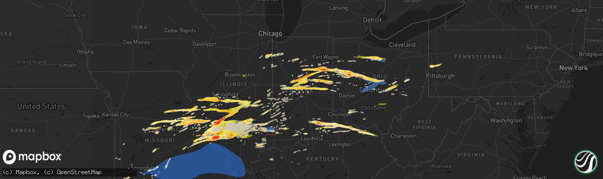
Hail Map in Indiana on March 14, 2024
The weather event in Indiana on March 14, 2024 includes Hail, Wind, and Tornado maps. 15 states and 1,835 cities were impacted and suffered possible damage. The total estimated number of properties impacted is 106,037.
Hail
Wind
Tornado
106,037
Estimated number of impacted properties by a 1.00" hail or larger28,314
Estimated number of impacted properties by a 1.75" hail or larger3,627
Estimated number of impacted properties by a 2.50" hail or largerStorm reports in Indiana
Indiana
| Date | Description |
|---|---|
| 03/14/20246:57 PM CDT | Relayed via social media... Time estimated from radar. |
| 03/14/20246:44 PM CDT | Time estimated from radar. |
| 03/14/20246:39 PM CDT | Reports 1.00 inch hail across montgomery county from ema and at i-74 and sr-32. |
| 03/14/20246:39 PM CDT | Damage to homes and trees. Possible tornado. Time estimated from radar. |
| 03/14/20246:37 PM CDT | Time estimated from radar. |
| 03/14/20246:37 PM CDT | *** 38 inj *** ef-3 tornado with maximum winds of 165 mph tracked from west of selma into ohio with a path length of 25.03 miles and maximum width of 700 yards. |
| 03/14/20246:35 PM CDT | A local report indicates 1.25 inch wind near Center |
| 03/14/20246:33 PM CDT | Time estimated from radar. |
| 03/14/20246:32 PM CDT | A local report indicates 1.00 inch wind near Clinton |
| 03/14/20246:30 PM CDT | A local report indicates 1.00 inch wind near 2 W Trenton |
| 03/14/20246:30 PM CDT | Southwest to south side of westfield reports of 1.00 to 1.25 inch hail. |
| 03/14/20246:30 PM CDT | Dime to quarter hail lasted from 730 to 733 pm at indiana route 32 and ditch road. |
| 03/14/20246:30 PM CDT | Dime to quarter hail lasted 62 report from mping: quarter . |
| 03/14/20246:28 PM CDT | Time estimated from radar. |
| 03/14/20246:28 PM CDT | A local report indicates 1.00 inch wind near 1 NW Atlanta |
| 03/14/20246:26 PM CDT | Photo of 2.00 hail 2 miles north of delaware county airport. Time estimated from radar. |
| 03/14/20246:22 PM CDT | Time estimated from radar. |
| 03/14/20246:19 PM CDT | A local report indicates 1.00 inch wind near 4 W Atlanta |
| 03/14/20246:18 PM CDT | A local report indicates 1.75 inch wind near Whitestown |
| 03/14/20246:16 PM CDT | Several large tree limbs snapped. Time estimated from radar. |
| 03/14/20246:12 PM CDT | A local report indicates 2.00 inch wind near Poneto |
| 03/14/20246:08 PM CDT | Report from mping: ping pong ball |
| 03/14/20246:04 PM CDT | A local report indicates 1.00 inch wind near 1 SSE Marion |
| 03/14/20246:01 PM CDT | Thunderstorm winds downed small tree. Time estimated from radar. |
| 03/14/20245:48 PM CDT | Home damage from hail. Time estimated from radar. |
| 03/14/20245:47 PM CDT | Photo of 2.85 inch hail in jerome. Time estimated from radar. |
| 03/14/20245:40 PM CDT | A local report indicates 1.50 inch wind near 1 N Fiat |
| 03/14/20245:40 PM CDT | Delayed report. Quarter size hail fell in gas city... In. Time given in social media report. |
| 03/14/20245:40 PM CDT | Damage found in far southeast adams county has been confirmed to be due to a tornado that began at 6:40 pm edt on march 14th. The tornado initially began over an open f |
| 03/14/20245:38 PM CDT | A local report indicates 1.00 inch wind near 1 E Sharpsville |
| 03/14/20245:38 PM CDT | A local report indicates 1.75 inch wind near 4 NE Sharpsville |
| 03/14/20245:35 PM CDT | Photo of 1.50 to 2.00 hail. Time estimated from radar. |
| 03/14/20245:27 PM CDT | Quarter size hail photo on twitter. Time estimated from radar. |
| 03/14/20245:26 PM CDT | Time estimated from radar. |
| 03/14/20245:25 PM CDT | A local report indicates 1.50 inch wind near 2 N Wells |
| 03/14/20245:21 PM CDT | A local report indicates 1.00 inch wind near 3 SW Michigantown |
| 03/14/20245:18 PM CDT | A local report indicates 1.50 inch wind near 2 N Dillman |
| 03/14/20245:18 PM CDT | Report from mping: quarter |
| 03/14/20245:15 PM CDT | Quarter size hail reported 2 sw of poneto. Time estimated from radar. |
| 03/14/20245:15 PM CDT | Delayed report. 2 inch hailstones fell at the intersection of in 218 and sr 1... Causing damage to siding and windows to several homes. Time estimated from radar. |
| 03/14/20245:14 PM CDT | Photo of 1.10 to 1.25 inch hail reported at intersection of 380 east and 100 north. Time estimated from radar. |
| 03/14/20245:13 PM CDT | Photo received on facebook of a measured 2.5 hailstone in poneto. Time estimated by radar. |
| 03/14/20245:13 PM CDT | Photo of 2.25 inch hail near michigantown. Time estimated from radar. |
| 03/14/20245:13 PM CDT | Delayed report. Facebook photo of a 2.5 inch hailstone near keystone... In. Time estimated from radar. |
| 03/14/20245:12 PM CDT | Corrects time of previous hail report from poneto. |
| 03/14/20245:09 PM CDT | Report from mping: half dollar |
| 03/14/20245:08 PM CDT | A local report indicates 1.00 inch wind near Frankfort |
| 03/14/20245:08 PM CDT | Time estimated from radar. |
| 03/14/20245:05 PM CDT | A local report indicates 2.00 inch wind near Mount Zion |
| 03/14/20245:04 PM CDT | A local report indicates 1.00 inch wind near 1 S Bluffton |
| 03/14/20245:04 PM CDT | A local report indicates 1.00 inch wind near Decatur |
| 03/14/20244:50 PM CDT | A local report indicates 1.50 inch wind near Santa Fe |
| 03/14/20244:50 PM CDT | Corrects time of previous hail report from santa fe. |
| 03/14/20244:42 PM CDT | A local report indicates 1.00 inch wind near 1 NW Jalapa |
| 03/14/20244:40 PM CDT | A local report indicates 1.75 inch wind near Warren |
| 03/14/20241:29 PM CDT | A local report indicates 1.00 inch wind near Vevay |
| 03/14/20241:29 PM CDT | Numerous windshields damaged. |
| 03/14/20241:29 PM CDT | Report from mping: quarter |
| 03/14/20241:05 PM CDT | A local report indicates 1.50 inch wind near 1 ENE North Madison |
| 03/14/20241:00 PM CDT | A local report indicates 2.00 inch wind near 3 SSW Wirt |
| 03/14/202412:58 PM CDT | A local report indicates 2.25 inch wind near Volga |
| 03/14/202412:58 PM CDT | *** 2 inj *** an nws storm survey found a 17.2 mile long ef-2 tornado with peak winds of 115 mph occurred on the afternoon of march 14... 2024. The tornado was on the g |
| 03/14/202411:48 AM CDT | Delayed report. Thunderstorm winds blew a semi across i-65 southbound near exit with indiana route 252. Time estimated from radar. |
| 03/14/202411:43 AM CDT | Scattered tree limbs broken. Probably only 30 to 40 mph wind gusts. |
| 03/14/202411:40 AM CDT | Damage to a power pole on sr-1 in bluffton. |
| 03/14/202411:09 AM CDT | Estimated 45-50 mph gusts downed 3 inch dead limb and many 1-2 inch limbs and snapped a flag pole. Time estimated from radar. |
| 03/14/202410:54 AM CDT | Several large tree branches downed along with childrens playset. Time estimated from radar. |
| 03/14/202410:02 AM CDT | Hail stopped at about 1106 am edt. |
| 03/14/20249:54 AM CDT | Tree down on state road 66 near pirtle road. |
| 03/13/202410:43 PM CDT | A local report indicates 1.25 inch wind near Santa Fe |
| 03/13/202410:36 PM CDT | Tree down on state road 203 at state road 3. |
| 03/13/202410:34 PM CDT | Tree down on state road 3. |
| 03/13/202410:15 PM CDT | Several telephone poles down on state road 66. |
| 03/13/202410:12 PM CDT | A local report indicates 1.00 inch wind near 1 ESE Chambersburg |
| 03/13/202410:07 PM CDT | Tree down on state road 335 near lovell road. |
| 03/13/20249:48 PM CDT | A local report indicates 1.00 inch wind near 1 N Marengo |
| 03/13/20249:45 PM CDT | A local report indicates 1.00 inch wind near 2 W Huntingburg |
| 03/13/20249:44 PM CDT | Social media report of several tree limbs downed along us150. Time estimated from radar. |
| 03/13/20249:31 PM CDT | A local report indicates 1.00 inch wind near 2 ESE Brownstown |
| 03/13/20249:25 PM CDT | Trees down with estimated 60 to 65 mph wind gusts at storm onset. Time estimated from radar. |
| 03/13/20249:20 PM CDT | Pea to quarter sized hail. |
| 03/13/20249:14 PM CDT | Large tree limbs down with power outages. |
| 03/13/20249:11 PM CDT | Trees of unknown sized downed. Time estimated from radar. |
| 03/13/20249:05 PM CDT | Tree down along east parker lake road. Time estimated from radar. |
| 03/13/20249:02 PM CDT | Report from mping: 3-inch tree limbs broken; power poles broken. |
| 03/13/20248:59 PM CDT | Shed blown into roadway... Time estimated from radar. |
| 03/13/20248:56 PM CDT | Social media picture of tree over road near bloomfield. Time estimated from radar. |
| 03/13/20248:40 PM CDT | Asos station kgez shelbyville. |
| 03/13/20248:16 PM CDT | Corrects previous tstm wnd dmg report from 2 ne ellettsville. Several large tree limbs snapped. Time estimated from radar. |
| 03/13/20248:10 PM CDT | Social media picture of several large tree limbs over road. Time estimated from radar. |
| 03/13/20248:10 PM CDT | Numerous small to medium sized tree limbs downed across town. |
| 03/13/20247:34 PM CDT | Tree over sr 240. Time estimated from radar. |
| 03/13/20247:22 PM CDT | A local report indicates 1.00 inch wind near 2 W Sulphur Springs |
| 03/13/20247:20 PM CDT | Ef2 tornado with winds to 120 mph confirmed in darke county oh and miami county oh in the nws wilmington oh forecast area. This tornado also affected portions of delawa |
| 03/13/20247:19 PM CDT | Time estimated from radar. |
| 03/13/20247:17 PM CDT | Thunderstorm winds downed a tree onto indiana route 38. Time estimated from radar. |
| 03/13/20247:03 PM CDT | Wind damage in winchester. Pictures videos and reports suggest likely tornado. Not confirmed. Time estimated from radar. |
All States Impacted by Hail Map on March 14, 2024
Cities Impacted by Hail Map on March 14, 2024
- Saint Augustine, IL
- Abingdon, IL
- Avon, IL
- Prairie City, IL
- Berwick, IL
- Eureka, KS
- Hamilton, KS
- Virgil, KS
- Gridley, KS
- Madison, KS
- Toronto, KS
- Yates Center, KS
- Burlington, KS
- Le Roy, KS
- Westphalia, KS
- Garnett, KS
- Waverly, KS
- Piqua, KS
- Downs, IL
- Le Roy, IL
- Ellsworth, IL
- Mora, MO
- Smithton, MO
- Florence, MO
- Otterville, MO
- Syracuse, MO
- Fortuna, MO
- Tipton, MO
- Clarksburg, MO
- Saint Anne, IL
- Momence, IL
- Kankakee, IL
- California, MO
- Latham, MO
- Pembroke Township, IL
- Lake Village, IN
- Schneider, IN
- Lowell, IN
- Tower Hill, IL
- Shelbyville, IL
- Lakewood, IL
- Martinsville, IL
- Annapolis, IL
- West York, IL
- West Union, IL
- Jefferson City, MO
- Holts Summit, MO
- Tebbetts, MO
- Indianapolis, IN
- Camby, IN
- Comanche, OK
- Duncan, OK
- Waurika, OK
- Macomb, OK
- Asher, OK
- Maud, OK
- Tecumseh, OK
- Marlow, OK
- Foster, OK
- Henrietta, TX
- Elmore City, OK
- Lindsay, OK
- Maysville, OK
- Pauls Valley, OK
- Ringling, OK
- Loco, OK
- Shawnee, OK
- Prague, OK
- Wetumka, OK
- Weleetka, OK
- Okemah, OK
- Henryetta, OK
- Okmulgee, OK
- Ringgold, TX
- Paris Crossing, IN
- Commiskey, IN
- Deputy, IN
- Madison, IN
- Lexington, IN
- Morris, OK
- Chouteau, OK
- Chamois, MO
- Twelve Mile, IN
- Arthur, IL
- Oblong, IL
- Star City, IN
- Kewanna, IN
- Crothersville, IN
- Brookston, IN
- Jasonville, IN
- Sullivan, IN
- Demotte, IN
- Farmersburg, IN
- Lewis, IN
- Shelburn, IN
- Terre Haute, IN
- Pimento, IN
- Odon, IN
- Newberry, IN
- Elnora, IN
- West Terre Haute, IN
- Sheldon, IL
- Kentland, IN
- Sedalia, MO
- Green Ridge, MO
- Ryan, OK
- Brazil, IN
- Earlsboro, OK
- Seminole, OK
- Cole Camp, MO
- Rosedale, IN
- Wanette, OK
- Herscher, IL
- Bonfield, IL
- Akron, IN
- Macy, IN
- Willow Hill, IL
- Yale, IL
- Clinton, IN
- Riley, IN
- New Goshen, IN
- Wewoka, OK
- Georgetown, IL
- Ridge Farm, IL
- Indianola, IL
- Castle, OK
- Wheatfield, IN
- Rensselaer, IN
- Fair Oaks, IN
- Paris, IL
- Wolcott, IN
- Mooresville, IN
- Monrovia, IN
- Chrisman, IL
- Holdenville, OK
- Freelandville, IN
- Sandborn, IN
- Oaktown, IN
- Bicknell, IN
- Edwardsport, IN
- Sullivan, IL
- Lovington, IL
- Paoli, OK
- Wayne, OK
- Byars, OK
- Francesville, IN
- Winamac, IN
- Byers, TX
- Vincennes, IN
- Plainville, IN
- Earl Park, IN
- Goodland, IN
- Ada, OK
- Aroma Park, IL
- Cook Sta, MO
- Onarga, IL
- Bainbridge, IN
- Roachdale, IN
- Lexington, OK
- Montezuma, IN
- Hillsdale, IN
- Pryor, OK
- Hanover, IN
- Milton, KY
- Nocona, TX
- Terral, OK
- Wynnewood, OK
- Stratford, OK
- Locust Grove, OK
- Boynton, OK
- Salina, OK
- Haskell, OK
- Vevay, IN
- Spavinaw, OK
- Porter, OK
- Taft, OK
- Gore, OK
- Jay, OK
- Vian, OK
- Grove, OK
- Park Hill, OK
- Cookson, OK
- Davis, OK
- Muskogee, OK
- South West City, MO
- Eucha, OK
- Colcord, OK
- Ghent, KY
- Florence, IN
- Warsaw, KY
- Sparta, KY
- Sanders, KY
- Glencoe, KY
- Dry Ridge, KY
- Carrollton, KY
- Sulphur, OK
- Anderson, MO
- Verona, KY
- Roff, OK
- Crittenden, KY
- Williamstown, KY
- Tahlequah, OK
- De Mossville, KY
- Falmouth, KY
- Wagoner, OK
- Gravette, AR
- Maysville, AR
- Sulphur Springs, AR
- Patriot, IN
- Butler, KY
- Foster, KY
- Eufaula, OK
- Checotah, OK
- Noel, MO
- Brooksville, KY
- Oktaha, OK
- Bella Vista, AR
- Hiwasse, AR
- Pineville, MO
- West Jefferson, OH
- London, OH
- Plain City, OH
- Hilliard, OH
- Dublin, OH
- Amlin, OH
- Galloway, OH
- Columbus, OH
- Lewis Center, OH
- Westerville, OH
- Galena, OH
- Powell, OH
- New Albany, OH
- Fort Gibson, OK
- Hulbert, OK
- Augusta, KY
- Germantown, KY
- Welling, OK
- Proctor, OK
- Mayslick, KY
- Mount Olivet, KY
- Maysville, KY
- Dover, KY
- Braggs, OK
- Bunch, OK
- Westville, OK
- Stilwell, OK
- Kansas, OK
- Watts, OK
- Stigler, OK
- Mokane, MO
- Steedman, MO
- Centralia, MO
- Sturgeon, MO
- Decatur, AR
- Gentry, AR
- Summers, AR
- Siloam Springs, AR
- Harrisburg, MO
- Fayetteville, AR
- Canehill, AR
- Lincoln, AR
- Evansville, AR
- Thompson, MO
- Mexico, MO
- Portland, MO
- Rhineland, MO
- Hermann, MO
- Springdale, AR
- Bentonville, AR
- Winslow, AR
- Prairie Grove, AR
- Farmington, AR
- West Fork, AR
- Morrow, AR
- Tollesboro, KY
- Rogers, AR
- Cave Springs, AR
- Lowell, AR
- Pea Ridge, AR
- Centerton, AR
- Bunceton, MO
- Pilot Grove, MO
- Berryville, AR
- Prairie Home, MO
- Boonville, MO
- Green Forest, AR
- Warrenton, MO
- Marthasville, MO
- Jonesburg, MO
- Goodman, MO
- Sullivan, MO
- Lonedell, MO
- Richwoods, MO
- Bourbon, MO
- Luebbering, MO
- Grubville, MO
- Dittmer, MO
- Elkins, AR
- Garfield, AR
- Laddonia, MO
- Rush Hill, MO
- Farber, MO
- Curryville, MO
- Vandalia, MO
- Porum, OK
- Middletown, MO
- Bowling Green, MO
- Mill Creek, OK
- Tishomingo, OK
- Pittsfield, IL
- Pearl, IL
- Winchester, IL
- Wallingford, KY
- Vanceburg, KY
- Hillsboro, MO
- Stonewall, OK
- Truesdale, MO
- Wright City, MO
- Foristell, MO
- Wentzville, MO
- Clever, MO
- Nixa, MO
- Ozark, MO
- Sparta, MO
- Montgomery City, MO
- Rogersville, MO
- New Florence, MO
- Fordland, MO
- Bruner, MO
- Wooldridge, MO
- Jamestown, MO
- Columbia, MO
- Oldfield, MO
- Seymour, MO
- Ava, MO
- Squires, MO
- Mansfield, MO
- Ashland, MO
- Clarksville, MO
- Sallisaw, OK
- Nebo, IL
- Eolia, MO
- Lake Saint Louis, MO
- O'Fallon, MO
- Pevely, MO
- Barnhart, MO
- Festus, MO
- Herculaneum, MO
- Webbers Falls, OK
- Waterloo, IL
- Smithton, IL
- New Athens, IL
- Tupelo, OK
- Golden Eagle, IL
- Saint Charles, MO
- Saint Peters, MO
- Drury, MO
- Norwood, MO
- Macomb, MO
- Mountain Grove, MO
- Marshfield, MO
- Hartville, MO
- Oak Grove, AR
- Lead Hill, AR
- Alpena, AR
- Omaha, AR
- Wesley, AR
- Eureka Springs, AR
- Hindsville, AR
- Huntsville, AR
- Lampe, MO
- Cedarcreek, MO
- Eagle Rock, MO
- Golden, MO
- Branson, MO
- Shell Knob, MO
- Hollister, MO
- Ridgedale, MO
- Blue Eye, MO
- Kirbyville, MO
- Marble Falls, AR
- Compton, AR
- Kingston, AR
- Ponca, AR
- Combs, AR
- Witter, AR
- Jasper, AR
- Harrison, AR
- Reeds Spring, MO
- Olive Hill, KY
- Emerson, KY
- Rockaway Beach, MO
- Grayson, KY
- Fulton, MO
- High Hill, MO
- Bellflower, MO
- Truxton, MO
- Hawk Point, MO
- Troy, MO
- Elsberry, MO
- Annada, MO
- Jacksonville, IL
- Murrayville, IL
- Woodson, IL
- Franklin, IL
- Waverly, IL
- Virden, IL
- Granite City, IL
- Konawa, OK
- Edwardsville, IL
- Williamsburg, MO
- Collinsville, IL
- Glen Carbon, IL
- Maryville, IL
- Troy, IL
- Valmeyer, IL
- Fults, IL
- Lynchburg, MO
- Grovespring, MO
- Graff, MO
- Plato, MO
- Huggins, MO
- Cabool, MO
- Houston, MO
- Vanzant, MO
- Solo, MO
- Bucyrus, MO
- Willow Springs, MO
- Elk Creek, MO
- Dora, MO
- Yellville, AR
- Theodosia, MO
- Rueter, MO
- Isabella, MO
- Protem, MO
- Kissee Mills, MO
- Peel, AR
- Oakland, AR
- Everton, AR
- Western Grove, AR
- Pyatt, AR
- Marine, IL
- Keota, OK
- La Fontaine, IN
- Bunker Hill, IN
- Marion, IN
- Miami, IN
- Highland, IL
- Amboy, IN
- Van Buren, IN
- Aviston, IL
- Warren, IN
- Montpelier, IN
- Trenton, IL
- Converse, IN
- Peru, IN
- Gans, OK
- Muldrow, OK
- Portage Des Sioux, MO
- Red Bud, IL
- Florissant, MO
- Hecker, IL
- Freeburg, IL
- Kinta, OK
- Auburn, IL
- Divernon, IL
- Pawnee, IL
- Thayer, IL
- Mascoutah, IL
- Belleville, IL
- Lenzburg, IL
- Mccurtain, OK
- Poneto, IN
- Liberty Center, IN
- Bluffton, IN
- Lebanon, IL
- Morrisonville, IL
- Potosi, MO
- Carrollton, IL
- Summerfield, IL
- Kane, IL
- Eldred, IL
- Centrahoma, OK
- Rockbridge, IL
- Saint James, MO
- Steelville, MO
- Coalgate, OK
- Greenfield, IL
- Frankfort, IN
- Colfax, IN
- Chesterfield, IL
- Medora, IL
- Saint Louis, MO
- Michigantown, IN
- Arnold, MO
- Imperial, MO
- East Alton, IL
- Wardville, OK
- South Roxana, IL
- Hartford, IL
- Stuart, OK
- Pocahontas, IL
- Fenton, MO
- Mcalester, OK
- Worden, IL
- Alhambra, IL
- Hamel, IL
- New Douglas, IL
- Livingston, IL
- East Carondelet, IL
- Blackwell, MO
- De Soto, MO
- Fletcher, MO
- Keystone, IN
- Geneva, IN
- Marietta, OK
- Roxana, IL
- Kiowa, OK
- Berne, IN
- Beulah, MO
- Edgar Springs, MO
- Lenox, MO
- Roby, MO
- Salem, MO
- Success, MO
- Licking, MO
- Raymondville, MO
- Jadwin, MO
- Eminence, MO
- Summersville, MO
- Yukon, MO
- Eunice, MO
- Hartshorn, MO
- Birch Tree, MO
- Mountain View, MO
- Caulfield, MO
- Peace Valley, MO
- Pomona, MO
- West Plains, MO
- Moody, MO
- Pottersville, MO
- Bakersfield, MO
- Elizabeth, AR
- Tecumseh, MO
- Gamaliel, AR
- Gepp, AR
- Henderson, AR
- Zanoni, MO
- Brixey, MO
- Bull Shoals, AR
- Gainesville, MO
- Gassville, AR
- Cotter, AR
- Flippin, AR
- Norfork, AR
- Summit, AR
- Lakeview, AR
- Valley Springs, AR
- Pontiac, MO
- Mountain Home, AR
- Saint Joe, AR
- Midway, AR
- Udall, MO
- Clarkridge, AR
- Calico Rock, AR
- Wasola, MO
- Hardenville, MO
- Thornfield, MO
- Prairie Du Rocher, IL
- Kempton, IN
- Forest, IN
- Russiaville, IN
- Tipton, IN
- Sharpsville, IN
- Taylorville, IL
- Bulpitt, IL
- Kincaid, IL
- Edinburg, IL
- Tovey, IL
- Goldsmith, IN
- Assumption, IL
- Stonington, IL
- Hettick, IL
- Carlinville, IL
- Rudy, AR
- Mountainburg, AR
- Columbia, IL
- Chester, AR
- Fort Smith, AR
- Barling, AR
- Lavaca, AR
- Alma, AR
- Van Buren, AR
- Dupo, IL
- Petroleum, IN
- Gillespie, IL
- Gainesville, TX
- Bokoshe, OK
- Spiro, OK
- Marissa, IL
- Addieville, IL
- Saint Libory, IL
- Litchfield, IL
- Shipman, IL
- O'Fallon, IL
- Haslet, TX
- Madill, OK
- Fort Worth, TX
- Rockford, OH
- Celina, OH
- Mendon, OH
- Hartford City, IN
- Cameron, OK
- Wabash, IN
- Inola, OK
- Wellsville, MO
- Fieldon, IL
- Kokomo, IN
- Ossian, IN
- Decatur, IN
- South Greenfield, MO
- Galveston, IN
- Walton, IN
- Markle, IN
- Walnut Shade, MO
- Dustin, OK
- Peebles, OH
- Brussels, IL
- Afton, OK
- Vinita, OK
- Thorntown, IN
- Darlington, IN
- Bradleyville, MO
- Healdton, OK
- Graham, OK
- Ratliff City, OK
- Springer, OK
- Scottsburg, IN
- Austin, IN
- Flemingsburg, KY
- Dupont, IN
- New Berlin, IL
- Scott Air Force Base, IL
- East Saint Louis, IL
- Greentown, IN
- Poteau, OK
- Huntington, IN
- Ladoga, IN
- Chelsea, OK
- Talala, OK
- Oologah, OK
- Sasakwa, OK
- Adair, OK
- Lebanon, IN
- Kirklin, IN
- Rose, OK
- Crystal City, MO
- Schell City, MO
- Monett, MO
- Purdy, MO
- Pierce City, MO
- Canadian, OK
- Hanna, OK
- Bryant, IN
- Pennville, IN
- Eldridge, MO
- Lebanon, MO
- Stoutland, MO
- Depew, OK
- Bristow, OK
- Ozark, AR
- Lamar, MO
- Auxvasse, MO
- Kingdom City, MO
- Broken Arrow, OK
- Strang, OK
- McCune, KS
- Cedarville, AR
- Aurora, MO
- Saint Jacob, IL
- Smithville, OK
- Heavener, OK
- Boles, AR
- Mena, AR
- West Alton, MO
- Powell, MO
- Washburn, MO
- Rocky Comfort, MO
- Forsyth, MO
- Taneyville, MO
- Venice, IL
- Caseyville, IL
- Lovejoy, IL
- Madison, IL
- Crawfordsville, IN
- New Bloomfield, MO
- Council Hill, OK
- Fitzhugh, OK
- Tunas, MO
- Buffalo, MO
- Milburn, OK
- White Hall, IL
- Kampsville, IL
- Liberal, MO
- Mindenmines, MO
- Windfall, IN
- Lanagan, MO
- Stella, MO
- Montreal, MO
- Mount Judea, AR
- Vendor, AR
- Galena, MO
- Kimberling City, MO
- Lagro, IN
- Bethany, IL
- Paden, OK
- Milton, IL
- Wood River, IL
- Rockville, MO
- Garrison, MO
- Chadwick, MO
- New Baden, IL
- Germantown, IL
- Bartelso, IL
- Carlyle, IL
- Albers, IL
- Camdenton, MO
- Billings, MO
- Natural Dam, AR
- Broken Bow, OK
- Ionia, MO
- Warner, OK
- Walnut, KS
- Saint Paul, KS
- Girard, KS
- Seligman, MO
- Fairview, MO
- Neosho, MO
- Stark City, MO
- Highlandville, MO
- La Russell, MO
- Chatham, IL
- Roanoke, TX
- Beggs, OK
- Indianola, OK
- Bowlegs, OK
- Uniontown, AR
- Whitefield, OK
- Swayzee, IN
- Jonesboro, IN
- Fairmount, IN
- Savanna, OK
- Butler, IL
- Moweaqua, IL
- Hillsboro, IL
- Argyle, TX
- Irving, IL
- Witt, IL
- Keller, TX
- Fort Jennings, OH
- Ottoville, OH
- Flower Mound, TX
- Krebs, OK
- Charleston, AR
- Findlay, IL
- Calvin, OK
- Saint Marys, OH
- Gas City, IN
- Mulberry, AR
- Windsor, IL
- Gays, IL
- Jamestown, IN
- Allen, OK
- Mattoon, IL
- Charleston, IL
- Sheridan, IN
- Atlanta, IN
- Nokomis, IL
- Fillmore, IL
- Arcadia, IN
- Denton, TX
- Waldron, AR
- Parks, AR
- Lewisville, TX
- Harvey, AR
- Hartshorne, OK
- Strasburg, IL
- Lamar, OK
- Ashmore, IL
- Findlay, OH
- Atwood, OK
- Coleman, OK
- Wapanucka, OK
- Caddo Gap, AR
- Norman, AR
- Lake Dallas, TX
- Little Elm, TX
- Aubrey, TX
- Fostoria, OH
- Arcadia, OH
- Alvada, OH
- Wapakoneta, OH
- New Riegel, OH
- Carey, OH
- Tiffin, OH
- Uniopolis, OH
- Whitestown, IN
- Zionsville, IN
- Dover, AR
- Pelsor, AR
- Carmel, IN
- Westfield, IN
- Noblesville, IN
- Gravelly, AR
- Bluffton, AR
- Bloomville, OH
- Republic, OH
- Attica, OH
- Summitville, IN
- Alexandria, IN
- Gaston, IN
- Muncie, IN
- Yorktown, IN
- Albany, IN
- Eaton, IN
- Wilburton, OK
- Watson, OK
- Fishers, IN
- Red Oak, OK
- Quinton, OK
- Cove, AR
- Hatfield, AR
- Lakeview, OH
- Frisco, TX
- Sycamore, OH
- New Bremen, OH
- New Knoxville, OH
- Botkins, OH
- Jackson Center, OH
- Lewistown, OH
- Belle Center, OH
- Huntsville, OH
- Prosper, TX
- Celina, TX
- Hamilton, MS
- Farmland, IN
- Parker City, IN
- Winchester, IN
- Ridgeville, IN
- Aberdeen, MS
- Pendleton, IN
- Greenwood Springs, MS
- Amory, MS
- Advance, IN
- New Washington, OH
- Atoka, OK
- Smithville, MS
- Willard, OH
- Hamilton, AL
- Tremont, MS
- Fulton, MS
- Briggsville, AR
- Danville, AR
- Russells Point, OH
- Bingham, IL
- Bonnerdale, AR
- Mount Ida, AR
- Plymouth, OH
- Shelby, OH
- Tiro, OH
- Markleville, IN
- Crowder, OK
- Millstadt, IL
- Coulterville, IL
- Oakdale, IL
- Mckinney, TX
- Nashville, IL
- Ashley, IL
- Plainview, AR
- Vina, AL
- Golden, MS
- Red Bay, AL
- Anna, TX
- New Castle, IN
- Shirley, IN
- Middletown, IN
- Kenefic, OK
- Shiloh, OH
- Greenwich, OH
- Leadwood, MO
- Irondale, MO
- Mineral Point, MO
- Davisville, MO
- Bonne Terre, MO
- Valles Mines, MO
- Cherryville, MO
- Belgrade, MO
- Bismarck, MO
- Park Hills, MO
- Cadet, MO
- Boss, MO
- Belleview, MO
- Bixby, MO
- Centerville, MO
- Viburnum, MO
- Ellington, MO
- Caledonia, MO
- French Village, MO
- Black, MO
- Bunker, MO
- Piedmont, MO
- Koshkonong, MO
- Redford, MO
- Fremont, MO
- Annapolis, MO
- Middle Brook, MO
- Van Buren, MO
- Pilot Knob, MO
- Lesterville, MO
- Alton, MO
- Arcadia, MO
- Vulcan, MO
- Ironton, MO
- Farmington, MO
- Winona, MO
- Doe Run, MO
- Bexar, AR
- Couch, MO
- Thayer, MO
- Viola, AR
- Camp, AR
- Mammoth Spring, AR
- Sturkie, AR
- Brandsville, MO
- Dolph, AR
- Salem, AR
- Raymond, OH
- West Mansfield, OH
- Marysville, OH
- Broadway, OH
- Ridgeway, OH
- Rushsylvania, OH
- Bellefontaine, OH
- Zanesfield, OH
- East Liberty, OH
- Oakland, IL
- Richwood, OH
- Oden, AR
- Trilla, IL
- Lerna, IL
- Van Alstyne, TX
- Staunton, IL
- Sorento, IL
- Jessieville, AR
- Mountain Pine, AR
- Hot Springs Village, AR
- Walshville, IL
- Panama, IL
- Donnellson, IL
- Hagerstown, IN
- Mooreland, IN
- Losantville, IN
- Coffeen, IL
- Union City, IN
- Saratoga, IN
- Ostrander, OH
- Magnetic Springs, OH
- Radnor, OH
- Belmont, MS
- Raymond, IL
- Rosamond, IL
- Pana, IL
- Oconee, IL
- Ramsey, IL
- Delaware, OH
- Caddo, OK
- Caney, OK
- Economy, IN
- Williamsburg, IN
- Modoc, IN
- Pencil Bluff, AR
- Greenville, IL
- Mulberry Grove, IL
- Smithboro, IL
- Vandalia, IL
- Richview, IL
- Hoyleton, IL
- Pocola, OK
- Woodlawn, IL
- Mount Vernon, IL
- Opdyke, IL
- Bluford, IL
- Belle Rive, IL
- Keenes, IL
- Wayne City, IL
- Sims, IL
- Fairfield, IL
- Beaver Falls, PA
- Rochester, PA
- Fombell, PA
- New Brighton, PA
- Zelienople, PA
- Harmony, PA
- Evans City, PA
- Renfrew, PA
- Connoquenessing, PA
- Butler, PA
- Beaver, PA
- Whitewright, TX
- Bono, AR
- Paragould, AR
- Sunbury, OH
- Tioga, TX
- Howe, TX
- Gunter, TX
- Blue Ridge, TX
- Leonard, TX
- Trenton, TX
- Stringtown, OK
- Lane, OK
- Thornville, OH
- Jacksontown, OH
- Heath, OH
- Hebron, OH
- Lonsdale, AR
- Paron, AR
- Benton, AR
- Glenford, OH
- Mount Perry, OH
- Hopewell, OH
- Nashport, OH
- Alexander, AR
- Little Rock, AR
- Croton, OH
- Centerburg, OH
- Johnstown, OH
- Utica, OH
- Newark, OH
- Alexandria, OH
- Granville, OH
- Saint Louisville, OH
- Zanesville, OH
- Frazeysburg, OH
- Dresden, OH
- Sims, AR
- Arkadelphia, AR
- Leola, AR
- Malvern, AR
- Westpoint, TN
- Iron City, TN
- Lawrenceburg, TN
- Loretto, TN
- Randolph, TX
- Bonham, TX
- Prattsville, AR
- Poyen, AR
- Patoka, IN
- Princeton, IN
- Saint Paris, OH
- Urbana, OH
- Celeste, TX
- Klondike, TX
- Cooper, TX
- Francisco, IN
- Roland, AR
- Patterson, MO
- Mill Spring, MO
- Ellsinore, MO
- Des Arc, MO
- Fredericktown, MO
- Silva, MO
- Patton, MO
- Marquand, MO
- Lodi, MO
- Sainte Genevieve, MO
- Marble Hill, MO
- Greenville, MO
- Clubb, MO
- Glenallen, MO
- Wappapello, MO
- Williamsville, MO
- Grandin, MO
- Oran, MO
- Chaffee, MO
- Brownwood, MO
- Whitewater, MO
- Bloomsdale, MO
- Zalma, MO
- Leopold, MO
- McGee, MO
- Lowndes, MO
- Sturdivant, MO
- Gipsy, MO
- Advance, MO
- Perryville, MO
- Bloomfield, MO
- Puxico, MO
- Bell City, MO
- Scott City, MO
- Bertrand, MO
- Friedheim, MO
- Jackson, MO
- Oak Ridge, MO
- Cape Girardeau, MO
- Vanduser, MO
- Sikeston, MO
- Millersville, MO
- Benton, MO
- Charleston, MO
- Daisy, MO
- Burfordville, MO
- Sedgewickville, MO
- Saint Mary, MO
- Ava, IL
- Cobden, IL
- Jacob, IL
- Chester, IL
- Cairo, IL
- McClure, IL
- Altenburg, MO
- Rockwood, IL
- Villa Ridge, IL
- Mounds, IL
- Miller City, IL
- Anna, IL
- Uniontown, MO
- Old Appleton, MO
- Ullin, IL
- Jonesboro, IL
- Wolf Lake, IL
- Pomona, IL
- Carbondale, IL
- Alto Pass, IL
- Makanda, IL
- Gorham, IL
- Frohna, MO
- Olive Branch, IL
- Pulaski, IL
- Murphysboro, IL
- Grand Tower, IL
- Tamms, IL
- Dongola, IL
- Thebes, IL
- Farrar, MO
- Campbell Hill, IL
- Steeleville, IL
- Ellis Grove, IL
- Modoc, IL
- Grantsburg, IL
- Belknap, IL
- Karnak, IL
- Kevil, KY
- Bardwell, KY
- Metropolis, IL
- Grand Chain, IL
- La Center, KY
- Buncombe, IL
- Goreville, IL
- Barlow, KY
- Paducah, KY
- Mound City, IL
- Vienna, IL
- Cypress, IL
- Melber, KY
- West Paducah, KY
- Cunningham, KY
- Wickliffe, KY
- Olmsted, IL
- Florence, AL
- Jonesboro, AR
- Brookland, AR
- Brookston, TX
- Sumner, TX
- Wolfe City, TX
- Summertown, TN
- Ethridge, TN
- Mount Pleasant, TN
- Mount Carmel, IL
- Allendale, IL
- Decker, IN
- Sumner, IL
- Saint Francisville, IL
- Hazleton, IN
- Monroe City, IN
- Petersburg, IN
- Loogootee, IN
- Cannelburg, IN
- Shoals, IN
- Bedford, KY
- Ashland City, TN
- English, IN
- Marengo, IN
- Palmyra, IN
- Pattonville, TX
- Paris, TX
- Blossom, TX
- Deport, TX
- Detroit, TX
- Pekin, IN
- Borden, IN
- Greenville, IN
- Clarksville, TX
- Russellville, AL
- Union City, OH
- Portland, IN
- Arcanum, OH
- New Madison, OH
- Chesterfield, MO
- Reelsville, IN
- Carbon, IN
- Cloverdale, IN
- Greencastle, IN
- Flora, IL
- Silex, MO
- Westfield, IL
- Casey, IL
- Story, AR
- Girard, IL
- Palmyra, IL
- Columbus Grove, OH
- Pandora, OH
- Rawson, OH
- Ottawa, OH
- Bluffton, OH
- Mount Cory, OH
- Hillsboro, IN
- Anderson, IN
- Alamo, IN
- Lapel, IN
- Fortville, IN
- New Ross, IN
- Waynetown, IN
- Vermilion, IL
- Berger, MO
- Savannah, TN
- Olivehill, TN
- Murray, KY
- Hazel, KY
- Sulligent, AL
- Nettleton, MS
- Columbus, MS
- Detroit, AL
- West Point, MS
- Selma, IN
- Frankton, IN
- Elwood, IN
- Dunkirk, IN
- Upland, IN
- Pilot Point, TX
- Clinton, AR
- Dennard, AR
- Batchtown, IL
- Cory, IN
- Bagwell, TX
- Mansfield, AR
- Piqua, OH
- Sparkman, AR
- Carthage, AR
- Fillmore, IN
- Versailles, MO
- Barnett, MO
- Russellville, MO
- Warsaw, OH
- Gurdon, AR
- McComb, OH
- Marshall, IN
- Rockville, IN
- House Springs, MO
- Bonnie, IL
- Ina, IL
- Campbell, TX
- Commerce, TX
- Cumby, TX
- Defiance, MO
- Augusta, MO
- Worthington, IN
- Switz City, IN
- Versailles, OH
- Greenville, OH
- Bradford, OH
- Norris City, IL
- Carmi, IL
- New Harmony, IN
- Enfield, IL
- Wadesville, IN
- New Haven, IL
- Mount Vernon, IN
- Hackett, AR
- Greenwood, AR
- Uniondale, IN
- Clayton, OK
- Centerpoint, IN
- Merom, IN
- Bridgeport, IL
- Flat Rock, IL
- Lawrenceville, IL
- Claremont, IL
- Olney, IL
- Okawville, IL
- Centertown, MO
- Poseyville, IN
- Evansville, IN
- Haubstadt, IN
- Batavia, OH
- Centralia, IL
- Pittsburg, OK
- Blanco, OK
- Lamar, AR
- Ardmore, OK
- Mannsville, OK
- Daisy, OK
- Hagarville, AR
- Carlisle, IN
- Palestine, IL
- Ansonia, OH
- Loami, IL
- Robertsville, MO
- Moscow Mills, MO
- Old Monroe, MO
- Hot Springs National Park, AR
- Maumelle, AR
- Griffin, IN
- Owensville, IN
- Antlers, OK
- Finley, OK
- Rattan, OK
- Collinwood, TN
- Lyons, IN
- Bloomfield, IN
- Scotland, IN
- Royal, AR
- Glenwood, AR
- Otisco, IN
- Marysville, IN
- Harrisburg, AR
- Bethel, OK
- Scranton, AR
- New Blaine, AR
- Washington, IN
- Hardinsburg, KY
- Roann, IN
- Booneville, AR
- Magazine, AR
- Stilesville, IN
- Coatesville, IN
- Parkersburg, IL
- Calhoun, IL
- New Paris, OH
- Fountain City, IN
- Richmond, IN
- Eldorado, OH
- Port Washington, OH
- Newcomerstown, OH
- Maryland Heights, MO
- Huntington, AR
- Eckerty, IN
- Taswell, IN
- Kingston, OK
- Hodgen, OK
- Fayetteville, OH
- Grand Junction, TN
- Upper Sandusky, OH
- Mount Orab, OH
- Goshen, OH
- Hillsboro, OH
- Williamsburg, OH
- Blanchester, OH
- Lynchburg, OH
- Marshall, AR
- Labadie, MO
- Leslie, AR
- Freeburg, MO
- Cypress Inn, TN
- Hampshire, TN
- London, AR
- Russellville, AR
- Eagletown, OK
- Clarksville, AR
- Oark, AR
- Waveland, IN
- Anna, OH
- Minster, OH
- Winslow, IN
- Ector, TX
- Springville, IN
- Miller, MO
- Middle Point, OH
- Van Wert, OH
- Hector, AR
- Alexander, IL
- Pleasant Plains, IL
- Ozone, AR
- Industry, PA
- Darlington, PA
- Justin, TX
- Muenster, TX
- Logansport, IN
- New Waverly, IN
- Jerusalem, AR
- Seymour, IN
- Marshall, IL
- Sheridan, AR
- Caldwell, OH
- Bloomington, IN
- Dennison, IL
- Mason, IL
- Louisville, IL
- Edgewood, IL
- Farina, IL
- Wheatland, IN
- North Salem, IN
- Danville, IN
- Greenfield, IN
- Mccordsville, IN
- Wheaton, MO
- Hartman, AR
- West Salem, IL
- Maplewood, OH
- Sidney, OH
- Roodhouse, IL
- Manila, AR
- Neoga, IL
- Mount Vernon, OH
- Hardin, IL
- Harned, KY
- Maria Stein, OH
- Saint Henry, OH
- Tuskahoma, OK
- Blue Mound, IL
- Kinmundy, IL
- Shobonier, IL
- Vernon, IL
- Alma, IL
- Patoka, IL
- Howe, OK
- Dix, IL
- Xenia, IL
- Pleasant Plain, OH
- Midland, OH
- Montgomery, IN
- Perryville, AR
- Mount Erie, IL
- Cisne, IL
- Waynesfield, OH
- De Graff, OH
- Quincy, OH
- Dodd City, TX
- Princeton, TX
- Bailey, TX
- Melissa, TX
- Bells, TX
- Savoy, TX
- Tom Bean, TX
- Sherman, TX
- Golden Gate, IL
- High Ridge, MO
- Cedar Hill, MO
- Thackerville, OK
- Saint Peter, IL
- Branch, AR
- Bethalto, IL
- Cumberland, OH
- Powersite, MO
- Daleville, MS
- Lauderdale, MS
- Dieterich, IL
- Nashoba, OK
- Arkoma, OK
- Shady Point, OK
- Albion, IL
- Avon, IN
- Brownsburg, IN
- Noble, IL
- Clay City, IL
- Ingraham, IL
- De Kalb, MS
- Meridian, MS
- Bailey, MS
- Paris, TN
- Crestwood, KY
- Smithfield, KY
- Fort Recovery, OH
- Coldwater, OH
- Atkins, AR
- Johnsonville, IL
- Walnut Hill, IL
- Texico, IL
- Iuka, IL
- Irvington, IL
- Kell, IL
- Keyesport, IL
- Hartford, AR
- North Little Rock, AR
- Whitesboro, TX
- Big Cabin, OK
- Marked Tree, AR
- Lepanto, AR
- Dyess, AR
- Grafton, IL
- Langley, AR
- Wickes, AR
- Cecil, AR
- Waynesboro, TN
- Selmer, TN
- Adamsville, TN
- Stantonville, TN
- Newton, IL
- Hohenwald, TN
- Shirley, AR
- Linton, IN
- Crossville, IL
- Grayville, IL
- Jeffersonville, IN
- Louisville, KY
- Haileyville, OK
- Coshocton, OH
- Clay City, IN
- Bowling Green, IN
- Ewing, IL
- Stewardson, IL
- Baldwin, IL
- Modesto, IL
- Rinard, IL
- Eureka, MO
- Glenarm, IL
- Waltonville, IL
- Rushville, OH
- Somerset, OH
- Chandlersville, OH
- New Lexington, OH
- Roseville, OH
- Cottage Grove, TN
- Puryear, TN
- Bellevue, TX
- Everton, MO
- Conesville, OH
- Pittsboro, IN
- Lizton, IN
- Scotland, AR
- Ratcliff, AR
- Wister, OK
- Roland, OK
- Paris, AR
- Altus, AR
- Pettigrew, AR
- Dyer, AR
- Fletcher, OH
- Conover, OH
- Washington, MO
- Moscow, TN
- Hickory Valley, TN
- La Grange, TN
- Caraway, AR
- Sandoval, IL
- Benton, IL
- Macedonia, IL
- Stover, MO
- State University, AR
- New Haven, MO
- Crooksville, OH
- New Washington, IN
- Nabb, IN
- Tippecanoe, OH
- Gnadenhutten, OH
- Uhrichsville, OH
- Kimbolton, OH
- Paoli, IN
- Hardinsburg, IN
- Bone Gap, IL
- Fairview Heights, IL
- Morris Chapel, TN
- Crump, TN
- Breese, IL
- Salem, IL
- Hoffman, IL
- Beckemeyer, IL
- Odin, IL
- Willshire, OH
- New Hampshire, OH
- Grissom Arb, IN
- New Market, IN
- Kingman, IN
- Veedersburg, IN
- Ingalls, IN
- Mount Sterling, MO
- Morrison, MO
- Linn, MO
- Clifton, TN
- Hasty, AR
- Pindall, AR
- Millersport, OH
- Pickerington, OH
- Buckeye Lake, OH
- Carroll, OH
- Canal Winchester, OH
- Baltimore, OH
- Grannis, AR
- Garvin, OK
- Palmer, IL
- Rives, TN
- Idabel, OK
- Mount Hope, AL
- Town Creek, AL
- Moulton, AL
- Trinity, AL
- Hillsboro, AL
- Decatur, AL
- Pulaski, TN
- Tanner, AL
- Ballinger, TX
- Talpa, TX
- Valera, TX
- Coleman, TX
- Bangs, TX
- Santa Anna, TX
- Santo, TX
- Lipan, TX
- Weatherford, TX
- Millsap, TX
- Granbury, TX
- Joelton, TN
- Millington, TN
- Ivanhoe, TX
- Ravenna, TX
- Helena, AR
- Lexa, AR
- West Helena, AR
- Cabot, AR
- Jacksonville, AR
- Milltown, IN
- Lewisville, AR
- Rossville, IN
- Ardmore, AL
- Elkmont, AL
- Athens, AL
- Toney, AL
- Turners Station, KY
- New Liberty, KY
- Worthville, KY
- Amity, AR
- Otwell, IN
- Rowena, TX
- Norton, TX
- Chillicothe, OH
- Pecan Gap, TX
- New Castle, KY
- Campbellsburg, KY
- Grapevine, AR
- White Hall, AR
- Butlerville, IN
- Horse Branch, KY
- Honey Grove, TX
- Windom, TX
- Roxton, TX
- Petty, TX
- Clarksdale, MS
- Crumrod, AR
- Alligator, MS
- Stuttgart, AR
- Saint Charles, AR
- Holly Grove, AR
- Marvell, AR
- Mead, OK
- Valley View, TX
- Calhoun, KY
- Utica, KY
- Smackover, AR
- Ranger, TX
- Eastland, TX
- Magnolia, AR
- Junction City, AR
- Emerson, AR
- El Dorado, AR
- Stevenson, AL
- Clarendon, AR
- Biscoe, AR
- Des Arc, AR
- Brinkley, AR
- Jonesville, KY
- Owenton, KY
- Prospect, TN
- Valliant, OK
- Jefferson, TX
- Karnack, TX
- Lonoke, AR
- Ladonia, TX
- Altheimer, AR
- Sherrill, AR
- Sherwood, AR
- Pottsboro, TX
- Austin, AR
- Conway, AR
- Almyra, AR
- Spruce Pine, AL
- Hazen, AR
- Carlisle, AR
- Princeton, AL
- Hartsburg, MO
- Kingston, OH
- Laurelville, OH
- Hattieville, AR
- Cleveland, AR
- Cynthiana, KY
- Berry, KY
- Manitou, KY
- Hanson, KY
- Dixon, KY
- Slaughters, KY
- Leighton, AL
- Lake City, AR
- Leitchfield, KY
- Scott, AR
- Little Rock Air Force Base, AR
- Kirby, AR
- Dierks, AR
- Umpire, AR
- Vine Grove, KY
- Ekron, KY
- Clarks Hill, IN
- Humnoke, AR
- Ulm, AR
- Wabbaseka, AR
- Tucker, AR
- England, AR
- Hopkinsville, KY
- North Vernon, IN
- De Witt, AR
- Arlington, TN
- Talihina, OK
- Mellwood, AR
- Pearcy, AR
- Elaine, AR
- Collinsville, TX
- Tyronza, AR
- Traskwood, AR
- Dundee, MS
- Sledge, MS
- Coahoma, MS
- Sulphur, KY
- Pendleton, KY
- Enloe, TX
- Mabelvale, AR
- Hollytree, AL
- Estillfork, AL
- Scottsboro, AL
- Corinth, KY
- Sadieville, KY
- Cotton Plant, AR
- Lake Creek, TX
- Mountain View, AR
- Fox, AR
- Bauxite, AR
- Salem, IN
- Campbellsburg, IN
- Humphrey, AR
- Memphis, TN
- Rhome, TX
- Perry Park, KY
- Bethlehem, KY
- Lockport, KY
- Newhope, AR
- Herndon, KY
- Honobia, OK
- Irvington, KY
- La Grange, KY
- Shelbyville, KY
- Phil Campbell, AL
- Fackler, AL
- New Market, AL
- Bridgeport, AL
- Gurley, AL
- Huntsville, AL
- Ardmore, TN
- Arthur City, TX
- Ozona, TX
- Dryden, TX
- Eldorado, TX
- Sonora, TX
- Minden, LA
- Christoval, TX
- Taylor, AR
- Marshall, TX
- Shelby, MS
- Duncan, MS
- Gunnison, MS
- Ida, LA
- Hosston, LA
- Vivian, LA
- Rodessa, LA
- Snow Lake, AR
- Stephenville, TX
- Winters, TX
- Oil City, LA
- Haynesville, LA
- Homer, LA
- Athens, LA
- Newark, TX
- Azle, TX
- Loving, NM
- Iraan, TX
- Sheffield, TX
- Monticello, AR
- Merigold, MS
- Lyon, MS
- Mingus, TX
- Leoma, TN
- Doddridge, AR
- Mound Bayou, MS
- Decatur, TX
- Bradley, AR
- Plain Dealing, LA
- Water Valley, MS
- Lovington, NM
- Caledonia, MS
- Gattman, MS
- Ponder, TX
- Shongaloo, LA
- Hazelwood, MO
- Bridgeton, MO
- Pleasureville, KY
- Mount Victory, OH
- La Rue, OH
- Austin, TX
- Catawissa, MO
- Union, MO
- Saint Clair, MO
- Saint Albans, MO
- Villa Ridge, MO
- Del Valle, TX
- Havana, AR
- Pacific, MO
- Adamsville, OH
- South Bloomingville, OH
- Rockbridge, OH
- Logan, OH


