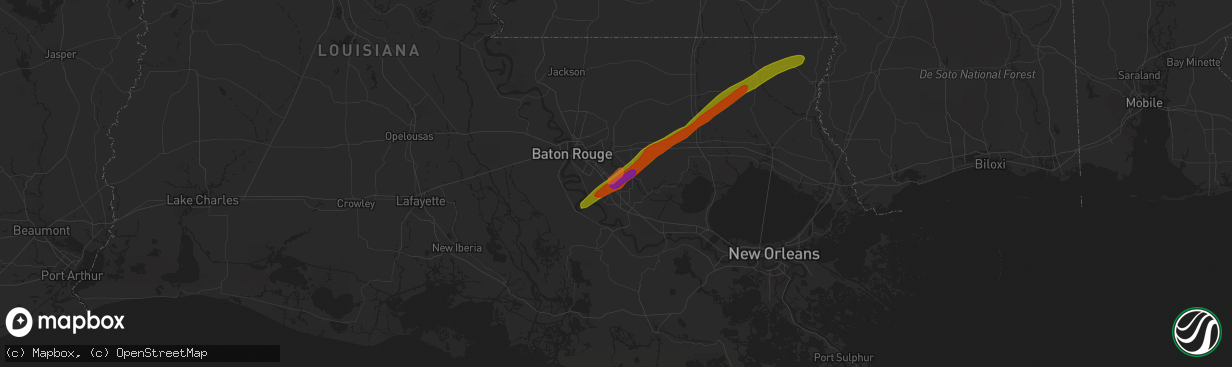
Hail Map in Prairieville, LA on February 11, 2024
The weather event in Prairieville, LA on February 11, 2024 includes Hail, Wind, and Tornado maps. 5 states and 289 cities were impacted and suffered possible damage. The total estimated number of properties impacted is 13,855.
Hail
Wind
Tornado
13,855
Estimated number of impacted properties by a 1.00" hail or larger19,181
Estimated number of impacted properties by a 1.75" hail or larger0
Estimated number of impacted properties by a 2.50" hail or largerStorm reports in Prairieville, LA
Prairieville, LA
| Date | Description |
|---|---|
| 02/11/202412:10 AM CST | Photo of hail in various sizes next to a penny... Quarter... Ping pong ball and ruler. Largest hail stone is oddly shaped and may be upwards of 2 inches in diameter or |
| 02/11/202412:07 AM CST | Report from mping: quarter |
| 02/11/202412:07 AM CST | Picture of golf ball sized hail by prairieville high school. Time estimated from radar. |
| 02/11/202412:05 AM CST | 1.5 inch hail |
| 02/11/202412:02 AM CST | Photo of hail... Estimated to be around quarter sized. Location in prairieville off highway 73. Time estimated from radar. |
All States Impacted by Hail Map on February 11, 2024
All Cities Impacted by Hail Map on February 11, 2024
- Tyler, TX
- Arp, TX
- Winona, TX
- Overton, TX
- Kilgore, TX
- Gladewater, TX
- Longview, TX
- Elkhart, TX
- Palestine, TX
- Troup, TX
- Henderson, TX
- Tatum, TX
- Beckville, TX
- Marshall, TX
- Hallsville, TX
- Rosanky, TX
- Smithville, TX
- Flatonia, TX
- Waskom, TX
- Karnack, TX
- Grapeland, TX
- Rusk, TX
- Alto, TX
- Cushing, TX
- Douglass, TX
- West Point, TX
- La Grange, TX
- Greenwood, LA
- College Station, TX
- Navasota, TX
- Anderson, TX
- Flint, TX
- Frankston, TX
- Whitehouse, TX
- Bullard, TX
- Larue, TX
- Chandler, TX
- Brownsboro, TX
- Murchison, TX
- Athens, TX
- Fayetteville, TX
- Ledbetter, TX
- Round Top, TX
- Shreveport, LA
- Mooringsport, LA
- Blanchard, LA
- Trinidad, TX
- Malakoff, TX
- Bossier City, LA
- Richards, TX
- Bedias, TX
- Huntsville, TX
- Barksdale Afb, LA
- Benton, LA
- Haughton, LA
- Kerens, TX
- Minden, LA
- Cotton Valley, LA
- Montgomery, TX
- Garrison, TX
- Nacogdoches, TX
- Oakhurst, TX
- Pointblank, TX
- Onalaska, TX
- Livingston, TX
- Arcadia, LA
- Dubach, LA
- Bernice, LA
- Moscow, TX
- Many, LA
- Robeline, LA
- Natchitoches, LA
- Marthaville, LA
- Gary, TX
- Joaquin, TX
- Price, TX
- Mansfield, LA
- Converse, LA
- Long Branch, TX
- Belmont, LA
- Tenaha, TX
- Mount Enterprise, TX
- Pleasant Hill, LA
- Carthage, TX
- Selman City, TX
- Logansport, LA
- Farmerville, LA
- Timpson, TX
- Saline, LA
- Marion, LA
- Bastrop, LA
- Goldonna, LA
- Plantersville, TX
- New Waverly, TX
- Princeton, LA
- Jacksonville, TX
- Oakwood, TX
- Muldoon, TX
- Buffalo, TX
- Belcher, LA
- Oil City, LA
- Somerville, TX
- De Berry, TX
- Hemphill, TX
- Coldspring, TX
- Willis, TX
- Corrigan, TX
- Downsville, LA
- Frierson, LA
- Bethany, LA
- Shepherd, TX
- Goodrich, TX
- Greenville, MS
- Hollandale, MS
- Indianola, MS
- Cleveland, TX
- Inverness, MS
- Leland, MS
- Saratoga, TX
- Warren, TX
- Burkeville, TX
- Newton, TX
- Wiergate, TX
- Hillister, TX
- Fred, TX
- Woodville, TX
- Spurger, TX
- Leesville, LA
- Fort Polk, LA
- Alexandria, LA
- Eudora, AR
- Pollock, LA
- Bentley, LA
- Dry Prong, LA
- Lexington, MS
- Broaddus, TX
- Chester, TX
- Boyce, LA
- Zavalla, TX
- Colfax, LA
- Colmesneil, TX
- Lena, LA
- Pitkin, LA
- Hineston, LA
- Jasper, TX
- Tuskegee, AL
- Hardaway, AL
- Tuskegee Institute, AL
- Kirbyville, TX
- Deridder, LA
- Hayneville, AL
- Letohatchee, AL
- Hope Hull, AL
- Parkdale, AR
- Newellton, LA
- Saint Joseph, LA
- Port Gibson, MS
- Vicksburg, MS
- Edwards, MS
- Utica, MS
- Bolton, MS
- Clinton, MS
- Jackson, MS
- Flora, MS
- Madison, MS
- Canton, MS
- Carthage, MS
- Camden, MS
- Brandon, MS
- Lena, MS
- Plaquemine, LA
- White Castle, LA
- Clayton, LA
- Ferriday, LA
- Tallulah, LA
- Shubuta, MS
- Quitman, MS
- Vossburg, MS
- New Iberia, LA
- Abbeville, LA
- Pineville, LA
- Elmer, LA
- Pachuta, MS
- Auburn, AL
- Ridgeland, MS
- Hermanville, MS
- Raymond, MS
- Jonesville, LA
- Deville, LA
- Center Point, LA
- Lowndesboro, AL
- Effie, LA
- Sicily Island, LA
- Harrisonburg, LA
- Monterey, LA
- Walnut Grove, MS
- Waterproof, LA
- Lecompte, LA
- Otis, LA
- Sieper, LA
- Silsbee, TX
- Saint Gabriel, LA
- Sunshine, LA
- Walker, LA
- Livingston, LA
- Holden, LA
- Independence, LA
- Amite, LA
- Franklinton, LA
- Tylertown, MS
- Denham Springs, LA
- Pine Grove, LA
- Sandy Hook, MS
- Franklin, LA
- Jeanerette, LA
- Kokomo, MS
- Foxworth, MS
- Columbia, MS
- Carville, LA
- Geismar, LA
- Prairieville, LA
- Bassfield, MS
- Sumrall, MS
- Seminary, MS
- Collins, MS
- Liberty, MS
- Smithdale, MS
- McCall Creek, MS
- Bogue Chitto, MS
- Brookhaven, MS
- Wesson, MS
- Ellisville, MS
- Soso, MS
- Laurel, MS
- Lumberton, MS
- Hattiesburg, MS
- Poplarville, MS
- Purvis, MS
- Baton Rouge, LA
- Gonzales, LA
- Albany, LA
- Tickfaw, LA
- Hammond, LA
- Loranger, LA
- Husser, LA
- Angie, LA
- Port Allen, LA
- Fluker, LA
- Kentwood, LA
- Saint Martinville, LA
- Greenwell Springs, LA
- Columbiana, AL
- Montevallo, AL
- Alabaster, AL
- Loreauville, LA
- Morgan City, LA
- Mount Hermon, LA
- Addis, LA
- Brusly, LA
- Napoleonville, LA
- Richton, MS
- Berwick, LA
- Gibson, LA
- Theriot, LA
- Patterson, LA
- Meridian, MS
- Butler, AL
- Lisman, AL
- Heidelberg, MS
- Mandeville, LA
- Lacombe, LA
- Thibodaux, LA
- Westwego, LA
- New Orleans, LA
- Marrero, LA
- Belle Rose, LA
- Pierre Part, LA
- Plattenville, LA
- Osyka, MS
- Saint James, LA
- Waynesboro, MS
- Mccomb, MS
- Magnolia, MS
- Ball, LA
- Bogalusa, LA
- Pelahatchie, MS
- Chatom, AL
- Morton, MS
- Gulfport, MS


